

Kobuk River
Encyclopedia
The Kobuk River
is a river
located in the Arctic
region of northwestern Alaska
in the United States
. It is approximately 280 miles (451 km) long. Draining a basin with an area of 12300 square miles (31,856.9 km²), the Kobuk River is among the largest rivers in northwest Alaska
with widths of up to 1500 feet (460 m) and flow at a speed of 3–5 miles per hour (5–8 km per hour) in its lower and middle reaches. The average elevation for the Kobuk River Basin is 1300 feet (396.2 m) above sea level, ranging from near sea level to 11,400 feet (3,475 m). Topography
includes low, rolling mountain
s, plain
s and lowland
s, moderately high rugged mountainous land, and some gently sloped plateau
s and highlands
. The river contains an exceptional population of sheefish
(Stenodus leucicthys), a large predatory whitefish
within the salmon family
, found throughout the Arctic that spawns in the river's upper reaches during the autumn. A portion of the vast Western Arctic Caribou Herd utilize the Kobuk river valley as winter range.
within the Gates of the Arctic National Park and Preserve
, just north of the Arctic Circle
. It flows briefly south, descending from the mountains through two spectacular canyons (Upper and Lower Kobuk Canyon), then flows generally west along the southern flank of the western Brooks Range
in a broad wetlands valley. In the valley it passes a connected community of inland native villages, including Kobuk, Shungnak, and Ambler, where it receives the Ambler River. In the river’s lower reaches, where it passes between the Baird and Warring mountains, it traverses Kobuk Valley National Park
, the location of the 25 square miles (64.7 km²) Kobuk Sand Dunes. It then passes Kiana. The river enters its broad delta
approximately 10 miles (16 km) southwest of Kiana. The delta is located in The Hotham Inlet of the Kotzebue Sound
approximately 30 miles (48 km) southeast of Kotzebue.
name means "big river". It was first transcribed by John Simpson in 1850 as "Kowuk." Explored by Lt. G. M. Stoney, USN, in 1883-1886, who wrote the name "Ku-buck," but proposed that it be called "Putnam" in honor of Master Charles Putnam
, USN, officer of the Rodgers, who was carried to sea on the ice and lost in 1880. Lt. J. C. Cantwell, USRCS, also explored the river in 1884 and 1885 and spelled the name "Koowak" on his map and "Kowak" in his text. Ivan Petroff
spelled the river name "Kooak" in 1880, and W. H. Dall spelled it "Kowk" in 1870. Lt. H. T. Allen, USA, obtained the Koyukon
Indian name in 1885 which he spelled "Holooatna" and "Holoatna."
Native peoples have hunted, fished, and lived along the Kobuk for at least 12,500 years and it has long been an important transportation route for inland peoples. In 1898 the river was the scene of a brief gold rush
called the Kobuk River Stampede
, which involved about 2,000 prospectors in total. Hearing of gold along the Kobuk and its tributaries, miners set out from Seattle and San Francisco on ships to reach the mouth of the Kobuk. Upon arrival they were informed by native people that it was a scam, and only about 800 traveled upriver. The result was that little or no gold was found, and only on a few tributaries of the river. In 1980 the United States Congress
designated 110 miles (177 km) of the river downstream from Walker Lake as the Kobuk Wild and Scenic River as part of the National Wild and Scenic Rivers System. The river is considered an outstanding destination for recreational floating.
and has a continental climate
. The summers are short and warm, while winters are long and cold. The mean annual temperature in the middle and upper portions of the Kobuk Valley is -6 °C, and the mean temperature in July is 15 °C. An average of 21 inches (53 cm) of precipitation falls in the basin. However, actual precipitation can range from 15-40 inches (40-100 cm) with greater amounts falling in the upper reaches of the river basin.
The Kobuk River Basin is very sensitive to changes in climate. Arctic climates have warmed
at approximately twice the global rate in the last several decades. Records of air-temperature from 1961 to 1990 logged at the latitudes of the Kobuk River, show a warming trend of about 1.4 °F (0.78 °C) per decade. The warming has been the strongest in the winter
and spring
months. Climate change is presently considered the most severe environmental stress in the Kobuk River Basin and throughout Alaska.
As a specific example, climate change will cause widespread thawing of permafrost
in the discontinuous
zone and significant changes in the continuous
zone. Thawing permafrost can lead to a landscape of irregular depressions (thermokarst
) due to subsiding soils. This can alter drainage
patterns and even change the course of streams; whereas other areas could become swamp
-like. In addition, slope stability will decrease and permafrost degradation could lead to erosion
of river banks resulting in an increase in sediment transport
by the rivers. These physical changes will impact nutrient cycling and biological processes within the basin as well.
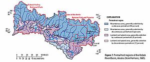 Permafrost
regions along the Kobuk River are shown in the accompanying figure.
. It cuts a channel through a landscape otherwise dominated by permafrost
. The Kobuk’s current form and structure is a direct result of several stages of erosion and channel formation following the last glacial retreat.
As the glacier first retreated and melted, large amounts of highly erodible, fine-grained sediment dropped out in relatively high mountain valleys. The availability of this fine-grained, loose sediment combined with a high gradient to turn a newly forming Kobuk River into a fast-working sediment transport system. The river picked up glacial till from its upper reaches and transported it downstream until the gradient diminished. When the river encountered flatter ground, it deposited its sediment load resulting in the creation of broad, flat floodplain
s, alluvial fan
s, and meander
bends through aggradation
.
After the first stage of aggradation and sediment transport, the Kobuk began a new phase of erosion and landform development. The river exhausted its supply of easily erodible sediment upstream, thus decreasing its sediment load and increasing its load carrying capacity downstream. With more capacity downstream, the river began to incise into the alluvial fan it previously created, moving sediment stored for a long time on its original floodplains to newer floodplains even further downstream.
Further down in the Kobuk watershed, the river worked in concert with the wind to create one of the more famous landforms in Alaska: the Kobuk Dunes. These large sand dunes are the modern ancestor of alluvial deposits that became shaped and dominated by an exchange of aeolian and fluvial
processes. In moister climates, the river has more water, and thus more power, and cuts down through a sandy bed. In times of drier climate, wind dominates and blows a lot of sediment into a weaker fluvial system, leading to aggradation and floodplain re-distribution.
Currently, the Kobuk River in its middle and lower reaches is an anastomizing
stream, with several braided
channels in places, wide migrating meander bends, and oxbow lakes. It is controlled by yearly cycles of freeze and thaw, much like its surrounding landscape. For six months of the year, the river is largely still, frozen on top by a thick layer of ice. In the spring, warmer temperatures cause this ice to begin to melt. But the resulting process is not gradual. Rather, the pressure of melting ice from upstream builds up upon ice “dams” in the river’s channel, eventually causing an “ice break-up” event, in which a flood of ice and water moves powerfully downstream.
These annual spring break-up events have several important consequences. First, the river has deeply undercut and eroded banks, caused by large, fast-moving chunks of ice carving out the river’s channel before it begins spilling out onto its floodplain, which is 1 to 6 miles (1.6-9.7 km) wide except at the confluence of major tributaries. Second, the river moves laterally very quickly and dramatically, re-inventing side channels every year as its secondary streams become drowned in each yearly flood by an overwhelming amount of sediment. Lastly, since the river is surrounded mostly by permafrost and because during the spring break-up event there are still large parts of frozen ground close to its banks, floods often transports large amounts of fine sediment across broad expanses of floodplain in thin sheets of water that slide easily across the frozen ground. These characteristics also translate into a relatively variable habitat for the Kobuk’s native species.
Farthest west, the Kobuk empties into Hotham Inlet, the easterly arm of Kotzebue Sound
. During recent geologic times however, when sea level was lower, the Noatak
, Kobuk, and Selawik River
s were joined. Now, they have separate deltas with many lakes and swamps and intricately webbed channel systems. The deltas are composed primarily of silt, sand, and gravel.
Most of the major tributaries of the Kobuk River flow from the north, draining the mountains in the southern Brooks Range
. From east to west, these include the Reed River, Beaver Creek, Mauneluk River, Kogoluktuk River, Shungnak River, Ambler River, Akillik River, Tutuksuk River, Salmon River, and the Squirrel River
. Within Kobuk Valley National Park
, are the Kallarichuk, Kaliguricheark, and Adillik rivers. All of their headwaters are in the Baird Mountains
. The major tributaries flowing north from the Waring Mountains are the Pah River, Pick River, and Niaktuvik Creek. The Pah River drains a lowland area of the basin. Most major tributaries draining high relief areas have higher unit runoff than tributaries draining the lower relief areas.
Walker Lake is at an altitude of 194 metres (636.5 ft) in the headwaters of the Kobuk River. Other surface water features within the basin include Lake Selby, Nutuvukti Lake, and Norutak Lake. Additionally, numerous small lakes and ponds occur in the lowlands along the river, some formed as detached oxbows of the meandering river and others formed where permafrost has melted and caused depressions.
Flow records are available from USGS
monitoring stations at Ambler and Kiana. Average annual flow for the Kobuk River at Ambler has ranged from 5839 cuft/s to 14890 cuft/s over the period of record 1966-78, with peak discharge ranging from 30000 cuft/s to 95000 cuft/s. Near Kiana, average annual flow has ranged from 10020 cuft/s to 24960 cuft/s for the period 1977-99 with peaks of 45000 cuft/s to 161000 cuft/s. Peak flows can result from large volumes of water released when ice jams fail. Flow records are also available for Dahl Creek, a tributary of the Kobuk River with a confluence near the town of Kobuk.
is a river
River
A river is a natural watercourse, usually freshwater, flowing towards an ocean, a lake, a sea, or another river. In a few cases, a river simply flows into the ground or dries up completely before reaching another body of water. Small rivers may also be called by several other names, including...
located in the Arctic
Arctic
The Arctic is a region located at the northern-most part of the Earth. The Arctic consists of the Arctic Ocean and parts of Canada, Russia, Greenland, the United States, Norway, Sweden, Finland, and Iceland. The Arctic region consists of a vast, ice-covered ocean, surrounded by treeless permafrost...
region of northwestern Alaska
Alaska
Alaska is the largest state in the United States by area. It is situated in the northwest extremity of the North American continent, with Canada to the east, the Arctic Ocean to the north, and the Pacific Ocean to the west and south, with Russia further west across the Bering Strait...
in the United States
United States
The United States of America is a federal constitutional republic comprising fifty states and a federal district...
. It is approximately 280 miles (451 km) long. Draining a basin with an area of 12300 square miles (31,856.9 km²), the Kobuk River is among the largest rivers in northwest Alaska
Alaska
Alaska is the largest state in the United States by area. It is situated in the northwest extremity of the North American continent, with Canada to the east, the Arctic Ocean to the north, and the Pacific Ocean to the west and south, with Russia further west across the Bering Strait...
with widths of up to 1500 feet (460 m) and flow at a speed of 3–5 miles per hour (5–8 km per hour) in its lower and middle reaches. The average elevation for the Kobuk River Basin is 1300 feet (396.2 m) above sea level, ranging from near sea level to 11,400 feet (3,475 m). Topography
Topography
Topography is the study of Earth's surface shape and features or those ofplanets, moons, and asteroids...
includes low, rolling mountain
Mountain
Image:Himalaya_annotated.jpg|thumb|right|The Himalayan mountain range with Mount Everestrect 58 14 160 49 Chomo Lonzorect 200 28 335 52 Makalurect 378 24 566 45 Mount Everestrect 188 581 920 656 Tibetan Plateaurect 250 406 340 427 Rong River...
s, plain
Plain
In geography, a plain is land with relatively low relief, that is flat or gently rolling. Prairies and steppes are types of plains, and the archetype for a plain is often thought of as a grassland, but plains in their natural state may also be covered in shrublands, woodland and forest, or...
s and lowland
Lowland
In physical geography, a lowland is any broad expanse of land with a general low level. The term is thus applied to the landward portion of the upward slope from oceanic depths to continental highlands, to a region of depression in the interior of a mountainous region, to a plain of denudation, or...
s, moderately high rugged mountainous land, and some gently sloped plateau
Plateau
In geology and earth science, a plateau , also called a high plain or tableland, is an area of highland, usually consisting of relatively flat terrain. A highly eroded plateau is called a dissected plateau...
s and highlands
Highland (geography)
The term highland or upland is used to denote any mountainous region or elevated mountainous plateau. Generally speaking, the term upland tends to be used for ranges of hills, typically up to 500-600m, and highland for ranges of low mountains.The Scottish Highlands refers to the mountainous...
. The river contains an exceptional population of sheefish
Inconnu
Stenodus leucichthys is a species of freshwater whitefish in the family Salmonidae. It is also known variously by the common names sheefish, inconnu, connie, nelma and beloribitsa...
(Stenodus leucicthys), a large predatory whitefish
Coregonus
Coregonus is a diverse genus of fish in the salmon family . The type species is the common whitefish . The Coregonus species are known as whitefishes...
within the salmon family
Salmonidae
Salmonidae is a family of ray-finned fish, the only living family currently placed in the order Salmoniformes. It includes salmon, trout, chars, freshwater whitefishes and graylings...
, found throughout the Arctic that spawns in the river's upper reaches during the autumn. A portion of the vast Western Arctic Caribou Herd utilize the Kobuk river valley as winter range.
Course
It is commonly assumed that the Kobuk River issues from Walker Lake. However, the headwaters of the river are to the east of Walker Lake in the Endicott MountainsEndicott Mountains
The Endicott Mountains are a range of mountains, part of the Brooks Range in northern Alaska. They are located in the middle of the Brooks range and run some east-west. To the east are the Philip Smith Mountains and to the west are the Schwatka Mountains...
within the Gates of the Arctic National Park and Preserve
Gates of the Arctic National Park and Preserve
Gates of the Arctic National Park and Preserve is a U.S. National Park in Alaska. It is the northernmost national park in the U.S. and the second largest at 13,238 mi² , about the same size as Switzerland. The park consists primarily of portions of the Brooks Range of mountains...
, just north of the Arctic Circle
Arctic Circle
The Arctic Circle is one of the five major circles of latitude that mark maps of the Earth. For Epoch 2011, it is the parallel of latitude that runs north of the Equator....
. It flows briefly south, descending from the mountains through two spectacular canyons (Upper and Lower Kobuk Canyon), then flows generally west along the southern flank of the western Brooks Range
Brooks Range
The Brooks Range is a mountain range in far northern North America. It stretches from west to east across northern Alaska and into Canada's Yukon Territory, a total distance of about 1100 km . The mountains top out at over 2,700 m . The range is believed to be approximately 126 million years old...
in a broad wetlands valley. In the valley it passes a connected community of inland native villages, including Kobuk, Shungnak, and Ambler, where it receives the Ambler River. In the river’s lower reaches, where it passes between the Baird and Warring mountains, it traverses Kobuk Valley National Park
Kobuk Valley National Park
Kobuk Valley National Park is in northwestern Alaska north of the Arctic Circle. It was designated a United States National Park in 1980 by the Alaska National Interest Lands Conservation Act. It is noted for the Great Kobuk Sand Dunes and caribou migration routes. The park offers backcountry...
, the location of the 25 square miles (64.7 km²) Kobuk Sand Dunes. It then passes Kiana. The river enters its broad delta
River delta
A delta is a landform that is formed at the mouth of a river where that river flows into an ocean, sea, estuary, lake, reservoir, flat arid area, or another river. Deltas are formed from the deposition of the sediment carried by the river as the flow leaves the mouth of the river...
approximately 10 miles (16 km) southwest of Kiana. The delta is located in The Hotham Inlet of the Kotzebue Sound
Kotzebue Sound
Kotzebue Sound is an arm of the Chukchi Sea in the western region of the U.S. state of Alaska. It is on the north side of the Seward Peninsula and bounded the east by the Baldwin Peninsula. It is long and wide....
approximately 30 miles (48 km) southeast of Kotzebue.
History
The Kobuk's InuitInuit
The Inuit are a group of culturally similar indigenous peoples inhabiting the Arctic regions of Canada , Denmark , Russia and the United States . Inuit means “the people” in the Inuktitut language...
name means "big river". It was first transcribed by John Simpson in 1850 as "Kowuk." Explored by Lt. G. M. Stoney, USN, in 1883-1886, who wrote the name "Ku-buck," but proposed that it be called "Putnam" in honor of Master Charles Putnam
Charles Putnam
Charles Flint Putnam was an officer in the United States Navy.-Biography:Born in Freeport, Illinois, Putnam entered the Naval Academy at the age of 14. Upon his request at graduation in 1873, he was ordered to the Far East in , serving in that vessel with the Asiatic Squadron until 1875...
, USN, officer of the Rodgers, who was carried to sea on the ice and lost in 1880. Lt. J. C. Cantwell, USRCS, also explored the river in 1884 and 1885 and spelled the name "Koowak" on his map and "Kowak" in his text. Ivan Petroff
Ivan Petrof (explorer)
Ivan Petrof was a soldier, writer, and translator who for many years was regarded a a major authority on Alaska. According to historian Terrence Cole, Petrof "holds the distinction of probably telling more lies about Alaska that were believed for more years than any other person in...
spelled the river name "Kooak" in 1880, and W. H. Dall spelled it "Kowk" in 1870. Lt. H. T. Allen, USA, obtained the Koyukon
Koyukon
The Koyukon are a group of Athabaskan people living in northern Alaska. Their traditional home is along the Koyukuk and Yukon rivers where they subsisted by hunting and trapping for thousands of years...
Indian name in 1885 which he spelled "Holooatna" and "Holoatna."
Native peoples have hunted, fished, and lived along the Kobuk for at least 12,500 years and it has long been an important transportation route for inland peoples. In 1898 the river was the scene of a brief gold rush
Gold rush
A gold rush is a period of feverish migration of workers to an area that has had a dramatic discovery of gold. Major gold rushes took place in the 19th century in Australia, Brazil, Canada, South Africa, and the United States, while smaller gold rushes took place elsewhere.In the 19th and early...
called the Kobuk River Stampede
Kobuk River Stampede
The Kobuk River Stampede was a brief gold rush on the Kobuk River in Alaska. From 1897 to 1898, several false accounts of the discovery of gold on the Kobuk led nearly 2,000 gold seekers to the area. Most of these prospectors arrived by ship, during the spring of 1898, from the West Coast of North...
, which involved about 2,000 prospectors in total. Hearing of gold along the Kobuk and its tributaries, miners set out from Seattle and San Francisco on ships to reach the mouth of the Kobuk. Upon arrival they were informed by native people that it was a scam, and only about 800 traveled upriver. The result was that little or no gold was found, and only on a few tributaries of the river. In 1980 the United States Congress
United States Congress
The United States Congress is the bicameral legislature of the federal government of the United States, consisting of the Senate and the House of Representatives. The Congress meets in the United States Capitol in Washington, D.C....
designated 110 miles (177 km) of the river downstream from Walker Lake as the Kobuk Wild and Scenic River as part of the National Wild and Scenic Rivers System. The river is considered an outstanding destination for recreational floating.
Climate
The Kobuk River Basin is located just north of the Arctic CircleArctic Circle
The Arctic Circle is one of the five major circles of latitude that mark maps of the Earth. For Epoch 2011, it is the parallel of latitude that runs north of the Equator....
and has a continental climate
Continental climate
Continental climate is a climate characterized by important annual variation in temperature due to the lack of significant bodies of water nearby...
. The summers are short and warm, while winters are long and cold. The mean annual temperature in the middle and upper portions of the Kobuk Valley is -6 °C, and the mean temperature in July is 15 °C. An average of 21 inches (53 cm) of precipitation falls in the basin. However, actual precipitation can range from 15-40 inches (40-100 cm) with greater amounts falling in the upper reaches of the river basin.
The Kobuk River Basin is very sensitive to changes in climate. Arctic climates have warmed
Global warming
Global warming refers to the rising average temperature of Earth's atmosphere and oceans and its projected continuation. In the last 100 years, Earth's average surface temperature increased by about with about two thirds of the increase occurring over just the last three decades...
at approximately twice the global rate in the last several decades. Records of air-temperature from 1961 to 1990 logged at the latitudes of the Kobuk River, show a warming trend of about 1.4 °F (0.78 °C) per decade. The warming has been the strongest in the winter
Winter
Winter is the coldest season of the year in temperate climates, between autumn and spring. At the winter solstice, the days are shortest and the nights are longest, with days lengthening as the season progresses after the solstice.-Meteorology:...
and spring
Spring (season)
Spring is one of the four temperate seasons, the transition period between winter and summer. Spring and "springtime" refer to the season, and broadly to ideas of rebirth, renewal and regrowth. The specific definition of the exact timing of "spring" varies according to local climate, cultures and...
months. Climate change is presently considered the most severe environmental stress in the Kobuk River Basin and throughout Alaska.
As a specific example, climate change will cause widespread thawing of permafrost
Permafrost
In geology, permafrost, cryotic soil or permafrost soil is soil at or below the freezing point of water for two or more years. Ice is not always present, as may be in the case of nonporous bedrock, but it frequently occurs and it may be in amounts exceeding the potential hydraulic saturation of...
in the discontinuous
Permafrost
In geology, permafrost, cryotic soil or permafrost soil is soil at or below the freezing point of water for two or more years. Ice is not always present, as may be in the case of nonporous bedrock, but it frequently occurs and it may be in amounts exceeding the potential hydraulic saturation of...
zone and significant changes in the continuous
Permafrost
In geology, permafrost, cryotic soil or permafrost soil is soil at or below the freezing point of water for two or more years. Ice is not always present, as may be in the case of nonporous bedrock, but it frequently occurs and it may be in amounts exceeding the potential hydraulic saturation of...
zone. Thawing permafrost can lead to a landscape of irregular depressions (thermokarst
Thermokarst
Thermokarst is a land surface characterised by very irregular surfaces of marshy hollows and small hummocks formed as ice-rich permafrost thaws, that occurs in Arctic areas, and on a smaller scale in mountainous areas such as the Himalayas and the Swiss Alps...
) due to subsiding soils. This can alter drainage
Drainage
Drainage is the natural or artificial removal of surface and sub-surface water from an area. Many agricultural soils need drainage to improve production or to manage water supplies.-Early history:...
patterns and even change the course of streams; whereas other areas could become swamp
Swamp
A swamp is a wetland with some flooding of large areas of land by shallow bodies of water. A swamp generally has a large number of hammocks, or dry-land protrusions, covered by aquatic vegetation, or vegetation that tolerates periodical inundation. The two main types of swamp are "true" or swamp...
-like. In addition, slope stability will decrease and permafrost degradation could lead to erosion
Erosion
Erosion is when materials are removed from the surface and changed into something else. It only works by hydraulic actions and transport of solids in the natural environment, and leads to the deposition of these materials elsewhere...
of river banks resulting in an increase in sediment transport
Sediment transport
Sediment transport is the movement of solid particles , typically due to a combination of the force of gravity acting on the sediment, and/or the movement of the fluid in which the sediment is entrained...
by the rivers. These physical changes will impact nutrient cycling and biological processes within the basin as well.
Geology and soils
Permafrost
In geology, permafrost, cryotic soil or permafrost soil is soil at or below the freezing point of water for two or more years. Ice is not always present, as may be in the case of nonporous bedrock, but it frequently occurs and it may be in amounts exceeding the potential hydraulic saturation of...
regions along the Kobuk River are shown in the accompanying figure.
Geomorphology
The Kobuk River is a periglacial river, fed by a remnant glacial lake (Walker Lake) and mountain snowmelt in the Brooks RangeBrooks Range
The Brooks Range is a mountain range in far northern North America. It stretches from west to east across northern Alaska and into Canada's Yukon Territory, a total distance of about 1100 km . The mountains top out at over 2,700 m . The range is believed to be approximately 126 million years old...
. It cuts a channel through a landscape otherwise dominated by permafrost
Permafrost
In geology, permafrost, cryotic soil or permafrost soil is soil at or below the freezing point of water for two or more years. Ice is not always present, as may be in the case of nonporous bedrock, but it frequently occurs and it may be in amounts exceeding the potential hydraulic saturation of...
. The Kobuk’s current form and structure is a direct result of several stages of erosion and channel formation following the last glacial retreat.
As the glacier first retreated and melted, large amounts of highly erodible, fine-grained sediment dropped out in relatively high mountain valleys. The availability of this fine-grained, loose sediment combined with a high gradient to turn a newly forming Kobuk River into a fast-working sediment transport system. The river picked up glacial till from its upper reaches and transported it downstream until the gradient diminished. When the river encountered flatter ground, it deposited its sediment load resulting in the creation of broad, flat floodplain
Floodplain
A floodplain, or flood plain, is a flat or nearly flat land adjacent a stream or river that stretches from the banks of its channel to the base of the enclosing valley walls and experiences flooding during periods of high discharge...
s, alluvial fan
Alluvial fan
An alluvial fan is a fan-shaped deposit formed where a fast flowing stream flattens, slows, and spreads typically at the exit of a canyon onto a flatter plain. A convergence of neighboring alluvial fans into a single apron of deposits against a slope is called a bajada, or compound alluvial...
s, and meander
Meander
A meander in general is a bend in a sinuous watercourse. A meander is formed when the moving water in a stream erodes the outer banks and widens its valley. A stream of any volume may assume a meandering course, alternately eroding sediments from the outside of a bend and depositing them on the...
bends through aggradation
Aggradation
Aggradation is the term used in geology for the increase in land elevation due to the deposition of sediment. Aggradation occurs in areas in which the supply of sediment is greater than the amount of material that the system is able to transport...
.
After the first stage of aggradation and sediment transport, the Kobuk began a new phase of erosion and landform development. The river exhausted its supply of easily erodible sediment upstream, thus decreasing its sediment load and increasing its load carrying capacity downstream. With more capacity downstream, the river began to incise into the alluvial fan it previously created, moving sediment stored for a long time on its original floodplains to newer floodplains even further downstream.
Further down in the Kobuk watershed, the river worked in concert with the wind to create one of the more famous landforms in Alaska: the Kobuk Dunes. These large sand dunes are the modern ancestor of alluvial deposits that became shaped and dominated by an exchange of aeolian and fluvial
Fluvial
Fluvial is used in geography and Earth science to refer to the processes associated with rivers and streams and the deposits and landforms created by them...
processes. In moister climates, the river has more water, and thus more power, and cuts down through a sandy bed. In times of drier climate, wind dominates and blows a lot of sediment into a weaker fluvial system, leading to aggradation and floodplain re-distribution.
Currently, the Kobuk River in its middle and lower reaches is an anastomizing
Anastomosis
An anastomosis is the reconnection of two streams that previously branched out, such as blood vessels or leaf veins. The term is used in medicine, biology, mycology and geology....
stream, with several braided
Braided river
A braided river is one of a number of channel types and has a channel that consists of a network of small channels separated by small and often temporary islands called braid bars or, in British usage, aits or eyots. Braided streams occur in rivers with high slope and/or large sediment load...
channels in places, wide migrating meander bends, and oxbow lakes. It is controlled by yearly cycles of freeze and thaw, much like its surrounding landscape. For six months of the year, the river is largely still, frozen on top by a thick layer of ice. In the spring, warmer temperatures cause this ice to begin to melt. But the resulting process is not gradual. Rather, the pressure of melting ice from upstream builds up upon ice “dams” in the river’s channel, eventually causing an “ice break-up” event, in which a flood of ice and water moves powerfully downstream.
These annual spring break-up events have several important consequences. First, the river has deeply undercut and eroded banks, caused by large, fast-moving chunks of ice carving out the river’s channel before it begins spilling out onto its floodplain, which is 1 to 6 miles (1.6-9.7 km) wide except at the confluence of major tributaries. Second, the river moves laterally very quickly and dramatically, re-inventing side channels every year as its secondary streams become drowned in each yearly flood by an overwhelming amount of sediment. Lastly, since the river is surrounded mostly by permafrost and because during the spring break-up event there are still large parts of frozen ground close to its banks, floods often transports large amounts of fine sediment across broad expanses of floodplain in thin sheets of water that slide easily across the frozen ground. These characteristics also translate into a relatively variable habitat for the Kobuk’s native species.
Farthest west, the Kobuk empties into Hotham Inlet, the easterly arm of Kotzebue Sound
Kotzebue Sound
Kotzebue Sound is an arm of the Chukchi Sea in the western region of the U.S. state of Alaska. It is on the north side of the Seward Peninsula and bounded the east by the Baldwin Peninsula. It is long and wide....
. During recent geologic times however, when sea level was lower, the Noatak
Noatak River
The Noatak River is a river in northwestern Alaska. The river's headwaters are on tall Mount Igikpak in the Schwatka Mountains of the Brooks Range in the Gates of the Arctic National Park. The Noatak flows generally westward approximately to the Chukchi Sea at Kotzebue Sound. The river's entire...
, Kobuk, and Selawik River
Selawik River
The Selawik River is a river in northwestern Alaska. It is about long. It runs from its origin in the Purcell Mountains through the Selawik National Wildlife Refuge and empties into Selawik Lake, which empties into the Kotzebue Sound in the Chukchi Sea. The river is approximately at the...
s were joined. Now, they have separate deltas with many lakes and swamps and intricately webbed channel systems. The deltas are composed primarily of silt, sand, and gravel.
Surface water and hydrology
The Kobuk River is ice covered 6 months of the year and in general, late October to late May is a period of relatively low flow. Annually, the hydrograph reflects two flood peaks: the first is associated with spring break-up and the second, a lesser peak, is associated with late summer precipitation. As the snowpack begins to melt toward the end of May, flow in the Kobuk River increases with most of the runoff occurring during June. Flow during the summer (July through September) is dominated by variable precipitation events.Most of the major tributaries of the Kobuk River flow from the north, draining the mountains in the southern Brooks Range
Brooks Range
The Brooks Range is a mountain range in far northern North America. It stretches from west to east across northern Alaska and into Canada's Yukon Territory, a total distance of about 1100 km . The mountains top out at over 2,700 m . The range is believed to be approximately 126 million years old...
. From east to west, these include the Reed River, Beaver Creek, Mauneluk River, Kogoluktuk River, Shungnak River, Ambler River, Akillik River, Tutuksuk River, Salmon River, and the Squirrel River
Squirrel River
The Squirrel River is a river in the U.S. state of Alaska. It is a tributary of the Kobuk River, which it flows into at the city of Kiana....
. Within Kobuk Valley National Park
Kobuk Valley National Park
Kobuk Valley National Park is in northwestern Alaska north of the Arctic Circle. It was designated a United States National Park in 1980 by the Alaska National Interest Lands Conservation Act. It is noted for the Great Kobuk Sand Dunes and caribou migration routes. The park offers backcountry...
, are the Kallarichuk, Kaliguricheark, and Adillik rivers. All of their headwaters are in the Baird Mountains
Baird Mountains
The Baird Mountains are a mountain range located northeast of the Kotzebue Sound, in between the Kobuk and Noatak Rivers in Alaska. The range was named after Smithsonian Institution Secretary, Spencer F. Baird.-Geographical setting:...
. The major tributaries flowing north from the Waring Mountains are the Pah River, Pick River, and Niaktuvik Creek. The Pah River drains a lowland area of the basin. Most major tributaries draining high relief areas have higher unit runoff than tributaries draining the lower relief areas.
Walker Lake is at an altitude of 194 metres (636.5 ft) in the headwaters of the Kobuk River. Other surface water features within the basin include Lake Selby, Nutuvukti Lake, and Norutak Lake. Additionally, numerous small lakes and ponds occur in the lowlands along the river, some formed as detached oxbows of the meandering river and others formed where permafrost has melted and caused depressions.
Flow records are available from USGS
United States Geological Survey
The United States Geological Survey is a scientific agency of the United States government. The scientists of the USGS study the landscape of the United States, its natural resources, and the natural hazards that threaten it. The organization has four major science disciplines, concerning biology,...
monitoring stations at Ambler and Kiana. Average annual flow for the Kobuk River at Ambler has ranged from 5839 cuft/s to 14890 cuft/s over the period of record 1966-78, with peak discharge ranging from 30000 cuft/s to 95000 cuft/s. Near Kiana, average annual flow has ranged from 10020 cuft/s to 24960 cuft/s for the period 1977-99 with peaks of 45000 cuft/s to 161000 cuft/s. Peak flows can result from large volumes of water released when ice jams fail. Flow records are also available for Dahl Creek, a tributary of the Kobuk River with a confluence near the town of Kobuk.
See also
- List of rivers of Alaska
- List of National Wild and Scenic Rivers
- Kobuk River StampedeKobuk River StampedeThe Kobuk River Stampede was a brief gold rush on the Kobuk River in Alaska. From 1897 to 1898, several false accounts of the discovery of gold on the Kobuk led nearly 2,000 gold seekers to the area. Most of these prospectors arrived by ship, during the spring of 1898, from the West Coast of North...