

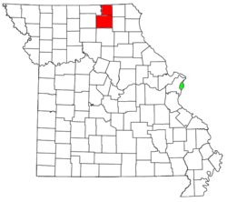
Kirksville micropolitan area
Encyclopedia
United States Census Bureau
The United States Census Bureau is the government agency that is responsible for the United States Census. It also gathers other national demographic and economic data...
, is an area consisting of two counties in Missouri
Missouri
Missouri is a US state located in the Midwestern United States, bordered by Iowa, Illinois, Kentucky, Tennessee, Arkansas, Oklahoma, Kansas and Nebraska. With a 2010 population of 5,988,927, Missouri is the 18th most populous state in the nation and the fifth most populous in the Midwest. It...
, anchored by the city of Kirksville
Kirksville, Missouri
Kirksville is the county seat of Adair County, Missouri, United States. It is located in Benton Township. The population was 17,505 at the 2010 census. Kirksville also anchors a micropolitan area that comprises Adair and Schuyler counties. The city is perhaps best known as the location of Truman...
. As of the 2000 census
United States Census, 2000
The Twenty-second United States Census, known as Census 2000 and conducted by the Census Bureau, determined the resident population of the United States on April 1, 2000, to be 281,421,906, an increase of 13.2% over the 248,709,873 persons enumerated during the 1990 Census...
, the μSA had a population of 29,147, and in the 2010 census the population was 30,008.
Cities
- BrashearBrashear, MissouriBrashear is a city in Salt River Township, Adair County, Missouri, United States. The population was 273 at the 2010 census. It is part of the Kirksville Micropolitan Statistical Area.-Geography:Brashear is located at...
- DowningDowning, MissouriDowning is a city in Schuyler County, Missouri, United States. The population was 335 at the 2010 census. It is part of the Kirksville Micropolitan Statistical Area.-Geography:Downing is located at ....
- GreentopGreentop, MissouriAs of the census of 2000, there were 427 people, 190 households, and 126 families residing in the city. The population density was 521.4 people per square mile . There were 221 housing units at an average density of 269.9 per square mile . The racial makeup of the city was 97.89% White, 0.23%...
- KirksvilleKirksville, MissouriKirksville is the county seat of Adair County, Missouri, United States. It is located in Benton Township. The population was 17,505 at the 2010 census. Kirksville also anchors a micropolitan area that comprises Adair and Schuyler counties. The city is perhaps best known as the location of Truman...
(Principal city) - LancasterLancaster, MissouriLancaster is a city in Schuyler County, Missouri, in the United States. As of the 2010 census, the city population was 728. It is the county seat of Schuyler County.Lancaster is part of the Kirksville Micropolitan Statistical Area.-Geography:...
- NovingerNovinger, MissouriNovinger is a city in Nineveh Township, Adair County, Missouri, United States. The population was 456 at the 2010 census. It is part of the Kirksville Micropolitan Statistical Area.-Geography:Novinger is located at ....
- Queen CityQueen City, MissouriQueen City is a city in Schuyler County, Missouri, United States. The population was 598 at the 2010 census. It is part of the Kirksville Micropolitan Statistical Area.-History:...
Villages
- GibbsGibbs, MissouriGibbs is a village in Wilson Township, Adair County, Missouri, United States. The population was 107 at the 2010 census. It is part of the Kirksville Micropolitan Statistical Area.-Geography:Gibbs is located at...
- GlenwoodGlenwood, MissouriGlenwood is a village in Schuyler County, Missouri, United States. The population was 196 at the 2010 census. It is part of the Kirksville Micropolitan Statistical Area.-History:...
- MillardMillard, MissouriMillard is a village in Pettis Township, Adair County, Missouri, United States. The population was 89 at the 2010 census. It is part of the Kirksville Micropolitan Statistical Area.-Geography:Millard is located at ....
Adair County
|
Pettis Township, Adair County, Missouri Pettis Township is one of ten townships in Adair County, Missouri, USA. As of the 2000 census, its population was 675. It is named for former US Congressman Spencer Pettis, who represented Missouri from 1829 to 1831 until being killed in a duel.-Geography:... Polk Township, Adair County, Missouri Polk Township is one of ten townships in Adair County, Missouri, USA. As of the 2000 census, its population was 551. It is named for US President James K. Polk.-Geography:Polk Township covers an area of and contains no incorporated settlements.... Salt River Township, Adair County, Missouri Salt River Township is one of ten townships in Adair County, Missouri, USA. As of the 2000 census, its population was 1,046.-Geography:Salt River Township covers an area of and contains one incorporated settlement, Brashear... Walnut Township, Adair County, Missouri Walnut Township is one of ten townships in Adair County, Missouri, USA. As of the 2000 census, its population was 262.-Geography:Walnut Township covers an area of and contains no incorporated settlements. It contains two cemeteries: Cheeseman and Hall.... Wilson Township, Adair County, Missouri Wilson Township is one of ten townships in Adair County, Missouri, USA. As of the 2000 census, its population was 415. It is named for Joseph Wilson, an early judge in Adair County.-Geography:... |
Schuyler County
|
|
Demographics
As of the censusCensus
A census is the procedure of systematically acquiring and recording information about the members of a given population. It is a regularly occurring and official count of a particular population. The term is used mostly in connection with national population and housing censuses; other common...
of 2000, there were 29,147 people, 11,394 households, and 6,539 families residing within the μSA. The racial makeup of the μSA was 96.19% White, 1.03% African American, 0.26% Native American, 1.21% Asian, 0.04% Pacific Islander, 0.38% from other races
Race (United States Census)
Race and ethnicity in the United States Census, as defined by the Federal Office of Management and Budget and the United States Census Bureau, are self-identification data items in which residents choose the race or races with which they most closely identify, and indicate whether or not they are...
, and 0.87% from two or more races. Hispanic or Latino of any race were 1.17% of the population.
The median income for a household in the μSA was $27,031, and the median income for a family was $36,325. Males had a median income of $25,974 versus $20,283 for females. The per capita income
Per capita income
Per capita income or income per person is a measure of mean income within an economic aggregate, such as a country or city. It is calculated by taking a measure of all sources of income in the aggregate and dividing it by the total population...
for the μSA was $15,667.