
Kingsdown, Kent
Encyclopedia
Kingsdown is a village immediately to the south of Walmer
, itself south of Deal
, on the English Channel
coast of Kent
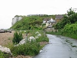
. Parts of the village are built on or behind the shingle beach that runs north to Deal and beyond, while other parts are on the cliffs and hills inland. The main road through the village is the steep hill of Upper Street, on which are located The Black Pig butcher shop and delicatessen, a hairdresser, a newsagent/general store, and a post office, as well as the village hall and vicarage. The village has three pubs: The Kings Head on Upper Street, The Rising Sun at the foot of the cliff, and the Zetland Arms on the beach. On the chalk uplands to the south are the Walmer & Kingsdown golf course, the Kingsdown International Camping Centre, and a large expanse of open land that used to be a scout camp. Beyond that is National Trust land stretching to Dover. Kingsdown has a primary school, which was built in 1997 on Glen Road in upper Kingsdown. Prior to that the school was situated in Ringwould, and was founded around 1873. The village church of St John the Evangelist was built by local landowner William Curling in 1848. Curling's former residence, Kingsdown House, was acquired by the Brightstone Holiday Centre in 1934 and a holiday camp, now known as Kingsdown Holiday Park, has operated in the grounds up to the present day. Kingsdown House itself, an imposing building visible from the beach, has variously been the clubhouse for the camp, a restaurant, and is now split into private residences.
Kingsdown was also at the southern end of the important anchorage known as The Downs
, which is sheltered between the coast of Kent and the Goodwin Sands
that lie offshore to the east. In the late 19th century, The Downs was widely used by hundreds of sailing ships that needed to ride out bad weather, although many ships came to grief on the Goodwins. A lifeboat station was built at Kingsdown in 1866 and was in operation until 1927. The nearest lifeboat is now based at Walmer to the north. From 1863, Oldstairs Bay at the south of Kingsdown Beach was also the location for an important Coastguard station and the substantial coastguard houses that remain (which are now privately occupied).
In 1926, the first woman to swim the English Channel, 19 year-old Gertrude Ederle
, made landfall at Kingsdown, after a 35-mile crossing (the direct distance is 21 miles) in record time. Kingsdown's proximity to France placed it on the front line of several wars. The defences at Walmer Castle
, one mile north of the village, recall historic threats in Tudor and Napoleonic times, but there is also a reminder of more recent conflicts south of Oldstairs Bay where the former Royal Marines
rifle range lies inland of concrete sea defences built by the Ministry of Defence
. During World War I, a military airfield operated from Hawkshill Freedown between Kingsdown and Walmer. In World War II, Kingsdown was the location for a secret radio transmitting ground station for Oboe
, that provided a navigation system designed to help aircraft locate themselves on operations over enemy occupied territory.
; the village itself sits below the chalk cliff and in the valleys leading down to the shore, with some outlying buildings and the holiday camp
on top or midway up. The chalk, which dates from the Cretaceous period, is a natural aquifer that forms the source for Kingsdown Water, which is extracted to the north west of the village. The Kingsdown foreshore is the most southerly point of a shingle bank and flood plain that stretches north to the Isle of Thanet
.
The beach and downs around the village are important for migrating birds and insects, and for rare plants. The beach and cliffs are part of the Site of Special Scientific Interest that stretches south to Folkestone. The beach is largely shingle but low tide exposes some sandy areas and a chalk shelf stretching out to sea, particularly in the area of Oldstairs Bay at the southern end.
connects the village to Walmer railway station
, which has direct trains to London
. Since 2009, this also provides a link to the high-speed domestic service High Speed 1 running to London St Pancras International, with connections at either Dover Priory, Ashford International or Ramsgate.
and the White Cliffs Country Trail. The section of National Cycle Route 1 known as the Cliffs and Castles route runs through Kingsdown on its way from Dover to Sandwich. A flat, purpose-built cycleway leads north from the outskirts of the village along the beach to Deal. In Kingsdown itself, part of the cycle route follows quiet public roads or footpaths.
Walmer
Walmer is a town in the district of Dover, Kent in England: located on the coast, the parish of Walmer is six miles north-east of Dover. Largely residential, its coastline and castle attract many visitors...
, itself south of Deal
Deal, Kent
Deal is a town in Kent England. It lies on the English Channel eight miles north-east of Dover and eight miles south of Ramsgate. It is a former fishing, mining and garrison town...
, on the English Channel
English Channel
The English Channel , often referred to simply as the Channel, is an arm of the Atlantic Ocean that separates southern England from northern France, and joins the North Sea to the Atlantic. It is about long and varies in width from at its widest to in the Strait of Dover...
coast of Kent
Kent
Kent is a county in southeast England, and is one of the home counties. It borders East Sussex, Surrey and Greater London and has a defined boundary with Essex in the middle of the Thames Estuary. The ceremonial county boundaries of Kent include the shire county of Kent and the unitary borough of...
. Parts of the village are built on or behind the shingle beach that runs north to Deal and beyond, while other parts are on the cliffs and hills inland. The main road through the village is the steep hill of Upper Street, on which are located The Black Pig butcher shop and delicatessen, a hairdresser, a newsagent/general store, and a post office, as well as the village hall and vicarage. The village has three pubs: The Kings Head on Upper Street, The Rising Sun at the foot of the cliff, and the Zetland Arms on the beach. On the chalk uplands to the south are the Walmer & Kingsdown golf course, the Kingsdown International Camping Centre, and a large expanse of open land that used to be a scout camp. Beyond that is National Trust land stretching to Dover. Kingsdown has a primary school, which was built in 1997 on Glen Road in upper Kingsdown. Prior to that the school was situated in Ringwould, and was founded around 1873. The village church of St John the Evangelist was built by local landowner William Curling in 1848. Curling's former residence, Kingsdown House, was acquired by the Brightstone Holiday Centre in 1934 and a holiday camp, now known as Kingsdown Holiday Park, has operated in the grounds up to the present day. Kingsdown House itself, an imposing building visible from the beach, has variously been the clubhouse for the camp, a restaurant, and is now split into private residences.
History
A settlement or hamlet at Kingsdown is described in antiquity. While the inland areas are devoted to farming, the modern village expanded in the 19th century as a fishing community. As at Deal and Walmer to the north, the steeply shelving shingle beach posed a challenge to the ingenuity of local fishermen, who installed fixed capstans along the shore in order to haul their boats out of the water. Many of the older sheds and houses on the beach date from this period.Kingsdown was also at the southern end of the important anchorage known as The Downs
The Downs
The Downs are a roadstead or area of sea in the southern North Sea near the English Channel off the east Kent coast, between the North and the South Foreland in southern England. In 1639 the Battle of the Downs took place here, when the Dutch navy destroyed a Spanish fleet which had sought refuge...
, which is sheltered between the coast of Kent and the Goodwin Sands
Goodwin Sands
The Goodwin Sands is a 10-mile-long sand bank in the English Channel, lying six miles east off Deal in Kent, England. The Brake Bank lying shorewards is part of the same geological unit. As the shoals lie close to major shipping channels, more than 2,000 ships are believed to have been wrecked...
that lie offshore to the east. In the late 19th century, The Downs was widely used by hundreds of sailing ships that needed to ride out bad weather, although many ships came to grief on the Goodwins. A lifeboat station was built at Kingsdown in 1866 and was in operation until 1927. The nearest lifeboat is now based at Walmer to the north. From 1863, Oldstairs Bay at the south of Kingsdown Beach was also the location for an important Coastguard station and the substantial coastguard houses that remain (which are now privately occupied).
In 1926, the first woman to swim the English Channel, 19 year-old Gertrude Ederle
Gertrude Ederle
Gertrude Caroline Ederle was an American competitive swimmer. In 1926, she became the first woman to swim across the English Channel. Gertrude Ederle was the daughter of a German immigrant who ran a butcher shop on Amsterdam Avenue in Manhattan; she was born in New York City. She was known as...
, made landfall at Kingsdown, after a 35-mile crossing (the direct distance is 21 miles) in record time. Kingsdown's proximity to France placed it on the front line of several wars. The defences at Walmer Castle
Walmer Castle
Walmer Castle was built by Henry VIII in 1539–1540 as an artillery fortress to counter the threat of invasion from Catholic France and Spain. It was part of his programme to create a chain of coastal defences along England's coast known as the Device Forts or as Henrician Castles...
, one mile north of the village, recall historic threats in Tudor and Napoleonic times, but there is also a reminder of more recent conflicts south of Oldstairs Bay where the former Royal Marines
Royal Marines
The Corps of Her Majesty's Royal Marines, commonly just referred to as the Royal Marines , are the marine corps and amphibious infantry of the United Kingdom and, along with the Royal Navy and Royal Fleet Auxiliary, form the Naval Service...
rifle range lies inland of concrete sea defences built by the Ministry of Defence
Ministry of Defence (United Kingdom)
The Ministry of Defence is the United Kingdom government department responsible for implementation of government defence policy and is the headquarters of the British Armed Forces....
. During World War I, a military airfield operated from Hawkshill Freedown between Kingsdown and Walmer. In World War II, Kingsdown was the location for a secret radio transmitting ground station for Oboe
Oboe (navigation)
Oboe was a British aerial blind bombing targeting system in World War II, based on radio transponder technology. Oboe accurately measured the distance to an aircraft, and gave the pilot guidance on whether or not they were flying along a pre-selected circular route. The route was only 35 yards...
, that provided a navigation system designed to help aircraft locate themselves on operations over enemy occupied territory.
Geography
Kingsdown is located at the northern end of the White Cliffs of DoverWhite cliffs of Dover
The White Cliffs of Dover are cliffs which form part of the British coastline facing the Strait of Dover and France. The cliffs are part of the North Downs formation. The cliff face, which reaches up to , owes its striking façade to its composition of chalk accentuated by streaks of black flint...
; the village itself sits below the chalk cliff and in the valleys leading down to the shore, with some outlying buildings and the holiday camp
Holiday camp
Holiday camp, in Britain, generally refers to a resort with a boundary that includes accommodation, entertainment and other facilities.As distinct from camping, accommodation typically consisted of chalets – small buildings arranged either individually or in blocks. Some had three or four storeys,...
on top or midway up. The chalk, which dates from the Cretaceous period, is a natural aquifer that forms the source for Kingsdown Water, which is extracted to the north west of the village. The Kingsdown foreshore is the most southerly point of a shingle bank and flood plain that stretches north to the Isle of Thanet
Isle of Thanet
The Isle of Thanet lies at the most easterly point of Kent, England. While in the past it was separated from the mainland by the nearly -wide River Wantsum, it is no longer an island ....
.
The beach and downs around the village are important for migrating birds and insects, and for rare plants. The beach and cliffs are part of the Site of Special Scientific Interest that stretches south to Folkestone. The beach is largely shingle but low tide exposes some sandy areas and a chalk shelf stretching out to sea, particularly in the area of Oldstairs Bay at the southern end.
Transport
There are no train stations in the village itself, but a bus service run by StagecoachStagecoach Group
Stagecoach Group plc is an international transport group operating buses, trains, trams, express coaches and ferries. The group was founded in 1980 by the current chairman, Sir Brian Souter, his sister, Ann Gloag, and her former husband Robin...
connects the village to Walmer railway station
Walmer railway station
Walmer railway station serves Walmer in Kent. The station and all trains serving it are operated by Southeastern.-Service: the typical off-peak service from the station is one train per hour to Ramsgate and one train per hour to London Charing Cross via Folkestone Central and Sevenoaks.-External...
, which has direct trains to London
London
London is the capital city of :England and the :United Kingdom, the largest metropolitan area in the United Kingdom, and the largest urban zone in the European Union by most measures. Located on the River Thames, London has been a major settlement for two millennia, its history going back to its...
. Since 2009, this also provides a link to the high-speed domestic service High Speed 1 running to London St Pancras International, with connections at either Dover Priory, Ashford International or Ramsgate.
Walking and cycling
Kingsdown has numerous local public footpaths and lies on both the Saxon Shore WaySaxon Shore Way
The Saxon Shore Way is a long-distance footpath in England, starting at Gravesend, Kent and traces the coast as it was in Roman times as far as Hastings, East Sussex, in total.-History:...
and the White Cliffs Country Trail. The section of National Cycle Route 1 known as the Cliffs and Castles route runs through Kingsdown on its way from Dover to Sandwich. A flat, purpose-built cycleway leads north from the outskirts of the village along the beach to Deal. In Kingsdown itself, part of the cycle route follows quiet public roads or footpaths.