
Kilimanjaro Region
Overview
Regions of Tanzania
Tanzania is divided into 26 regions.-See also:* list of Tanzanian regions by area ranks the regions by their total area, land area, and water area.* Districts of Tanzania* ISO 3166-2:TZ-External links:*...
in Tanzania
Tanzania
The United Republic of Tanzania is a country in East Africa bordered by Kenya and Uganda to the north, Rwanda, Burundi, and the Democratic Republic of the Congo to the west, and Zambia, Malawi, and Mozambique to the south. The country's eastern borders lie on the Indian Ocean.Tanzania is a state...
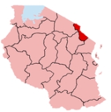
. The capital of the region is Moshi
Moshi
Moshi is a Tanzanian town with a population of 144,739 in Kilimanjaro Region. The town is situated on the lower slopes of Mt Kilimanjaro, a volcanic mountain that is the highest mountain in Africa....
. Kilimanjaro region is home to Mount Kilimanjaro
Mount Kilimanjaro
Kilimanjaro, with its three volcanic cones, Kibo, Mawenzi, and Shira, is a dormant volcano in Kilimanjaro National Park, Tanzania and the highest mountain in Africa at above sea level .-Geology:...
.
Kilimanjaro Region is bordered to the North and East by Kenya
Kenya
Kenya , officially known as the Republic of Kenya, is a country in East Africa that lies on the equator, with the Indian Ocean to its south-east...
, to the South by the Tanga Region
Tanga Region
Tanga Region is one of the 26 regions of Tanzania. The regional headquarters is in Tanga. According to the 2002 Tanzania National Census, the region has a population of 1,642,015 people....
, to the Southwest by the Manyara Region
Manyara Region
Manyara is one of the 26 Regions of Tanzania. Babati serves as the Region's capital. In its northern part is Lake Manyara. It is bordered to the north by the Arusha Region, to the northeast by the Kilimanjaro Region, to the east by the Tanga Region, to the south by the Dodoma Region, to the...
, and to the West by the Arusha Region
Arusha Region
Arusha is one of Tanzania's 26 administrative regions. The regional capital and largest city is Arusha. Other towns include Monduli, just west of Arusha, Longido and Loliondo to the north, Mto Wa Mbu and Karatu to the west and Usa River to the east...
.
According to the 2002 Tanzania National Census, the population of the Kilimanjaro Region was 1,381,149.
The Regional Commissioner of the Kilimanjaro Region is M.O.
Unanswered Questions