
Kien Giang Province
Encyclopedia
Kiên Giang is a province
of Vietnam
, located in the Mekong Delta
region of southern Vietnam
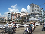
. It is known for fishing and rice farming. The provincial capital is Rạch Giá
, 250 km from the Ho Chi Minh City
. Kien Giang's dimension is about 6.299 km² and its population is about 1,634,043, of which 22 percent live in the urban area.
Kien Giang is bordered with An Giang province
in the northeast, Cần Thơ and Hau Giang
in the east, Bac Lieu
in the southeast and Cà Mau
in the south, and Kampot Province of Cambodia
(with the 54km border) in the west, Gulf of Thailand
in the southwest (with the 200km coast).
According to survey results in April 1, 2009, Kien Giang province's population is 1,683,149 people.
By the reign of Minh Mang, in 1832, Ha Tien is one of the six provinces of the South.
In 1876, Southern France divided into four big administrative regions, each region divided into smaller administrative sub-district or county take action (administratif arrondissement), Ha Tien, the former being divided into two particle parameters are Ha Tien and Rach Gia. From January 1, 1900 two-particle parameters of Ha Tien and Rach Gia became provinces of Ha Tien and Rach Gia.
Since the Republic of Vietnam, Hà Tiên
and Rạch Giá
merged to Kiên Giang. Kiên Giang were including seven counties at that time: Kien Luong, Kien An, Kien Binh, Tan Kien Kien Thanh and Phu Quoc. Kien Giang province are bordering the Cambodia to the north, Chau Doc to the northeast, An Giang province to the east and Phong Dinh Province, Chuong Thien to the southeast, An Xuyen to the south.
), one town (Hà Tiên
), and thirteen districts (huyện) :
Provinces of Vietnam
Vietnam is divided into 58 provinces and five centrally governed cities existing at the same level as provinces ....
of Vietnam
Vietnam
Vietnam – sometimes spelled Viet Nam , officially the Socialist Republic of Vietnam – is the easternmost country on the Indochina Peninsula in Southeast Asia. It is bordered by China to the north, Laos to the northwest, Cambodia to the southwest, and the South China Sea –...
, located in the Mekong Delta
Mekong Delta
The Mekong Delta is the region in southwestern Vietnam where the Mekong River approaches and empties into the sea through a network of distributaries. The Mekong delta region encompasses a large portion of southwestern Vietnam of . The size of the area covered by water depends on the season.The...
region of southern Vietnam
Southern Vietnam
For the former country, see South VietnamSouthern Vietnam is one of the three regions within Vietnam .The largest city in the South is Ho Chi Minh City, the nation's largest city....
. It is known for fishing and rice farming. The provincial capital is Rạch Giá
Rach Gia
Rạch Giá is the capital city of Kien Giang province, Vietnam. It is located around on the coast of Gulf of Thailand, 250 kilometers from Ho Chi Minh City...
, 250 km from the Ho Chi Minh City
Ho Chi Minh City
Ho Chi Minh City , formerly named Saigon is the largest city in Vietnam...
. Kien Giang's dimension is about 6.299 km² and its population is about 1,634,043, of which 22 percent live in the urban area.
Kien Giang is bordered with An Giang province
An Giang Province
An Giang is a province of Vietnam. It is located in the Mekong Delta, in the southwestern part of the country, sharing a border with Cambodia to the northwest.- Geography :...
in the northeast, Cần Thơ and Hau Giang
Hau Giang Province
Hậu Giang became Can Tho province during/after 1975. Can Tho was the capital of Can Tho province. It is located in the Mekong Delta of southern Vietnam. In late 2004, Can Tho and some surrounding cities became Can Tho Municipality . The remainder of Cần Thơ province became Hậu Giang province .Vi...
in the east, Bac Lieu
Bac Lieu Province
Bạc Liêu is a province of Vietnam. It is a coastal province, and is situated in the Mekong Delta region of the southern part of the country.- Name :Formally a territoy of Cambodia, the name Bac Lieu is believed to derive from the Khmer language...
in the southeast and Cà Mau
Ca Mau Province
Cà Mau is a province of Vietnam, named after its capital city. It is located in the Mekong Delta of southern Vietnam, and is the southernmost of Vietnam's 58 provinces...
in the south, and Kampot Province of Cambodia
Cambodia
Cambodia , officially known as the Kingdom of Cambodia, is a country located in the southern portion of the Indochina Peninsula in Southeast Asia...
(with the 54km border) in the west, Gulf of Thailand
Gulf of Thailand
The Gulf of Thailand , also known in to Malays as Teluk Siam literally meant Gulf of Siam, is a shallow arm of the South China Sea.-Geography:...
in the southwest (with the 200km coast).
According to survey results in April 1, 2009, Kien Giang province's population is 1,683,149 people.
General
- Coordinates: 9°23'50" N to 10°32'30" N, 104°40' E to 105°32'40" E.
- Area: 6,299 km², 4,119.74 km² of agricultural land (66% natural area), private land for rice accounted for 3,170.19 km² (77% of agricultural land). Forest land is 1,200.27 km² (19% natural area). The province also funds unused land near the 500.00 km².
Climate
- Average annual rainfall: mm (for land);
- Average temperature: 27,3 °C;
- Hours of sunshine/year:
- Dry season: from 7 to 8 hours/day.
- Rainy Season: from 4 to 6 hours/day.
- Average relative humidity: 80 to 83%.
History
In 1774, Lord Nguyen Phuc Dang Khoat divided into 12 in the palace, but still leave the town of Ha Tien, Mac Thien Tich style as Admiral rule.By the reign of Minh Mang, in 1832, Ha Tien is one of the six provinces of the South.
In 1876, Southern France divided into four big administrative regions, each region divided into smaller administrative sub-district or county take action (administratif arrondissement), Ha Tien, the former being divided into two particle parameters are Ha Tien and Rach Gia. From January 1, 1900 two-particle parameters of Ha Tien and Rach Gia became provinces of Ha Tien and Rach Gia.
Since the Republic of Vietnam, Hà Tiên
Hà Tiên
Hà Tiên or Ha Tien is a town in Kien Giang Province, Tay Nam Bo of Vietnam. Area: 8,851.5 ha, population : 39,957. The town borders Cambodia to the west....
and Rạch Giá
Rach Gia
Rạch Giá is the capital city of Kien Giang province, Vietnam. It is located around on the coast of Gulf of Thailand, 250 kilometers from Ho Chi Minh City...
merged to Kiên Giang. Kiên Giang were including seven counties at that time: Kien Luong, Kien An, Kien Binh, Tan Kien Kien Thanh and Phu Quoc. Kien Giang province are bordering the Cambodia to the north, Chau Doc to the northeast, An Giang province to the east and Phong Dinh Province, Chuong Thien to the southeast, An Xuyen to the south.
Administrative divisions
Kiên Giang is divided into one city (Rạch GiáRach Gia
Rạch Giá is the capital city of Kien Giang province, Vietnam. It is located around on the coast of Gulf of Thailand, 250 kilometers from Ho Chi Minh City...
), one town (Hà Tiên
Hà Tiên
Hà Tiên or Ha Tien is a town in Kien Giang Province, Tay Nam Bo of Vietnam. Area: 8,851.5 ha, population : 39,957. The town borders Cambodia to the west....
), and thirteen districts (huyện) :
- An Biên
- An Minh
- Châu Thành
- Giang Thành
- Giồng Riềng
- Gò Quao
- Hòn Đất
- Kiên Hải
- Kiên Lương
- Phú Quốc
- Tân Hiệp
- Vĩnh Thuận
- U Minh Thượng