
Khulna Division
Encyclopedia
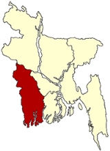
Khulna Division is one of the seven divisions of Bangladesh
and is located in the south-west of the country. It has an area of 22,285 km2 and a population of 15,563,000 at the 2011 Census (preliminary returns). Its headquarters is Khulna
city in Khulna District
.
n state of West Bengal
to the west, the Rajshahi Division to the north, the Dhaka and Barisal Division
s to the east, and has a coastline on the Bay of Bengal
to the south. It is part of the Ganges River
delta
or Greater Bengal Delta. Other rivers include the Madhumati River, the Bhairob River and the Kopotokkho River. The region also includes several islands in the Bay of Bengal
.
's main foreign currency earner Jute industry. There are many large Jute mills
located in Khalishpur near Khulna city processing Jute
fiber, besides the other heavy industries like Khulna News Print Mills and Khulna Hardboard Mills. The country's second seaport, Mongla Port, and the country's only ship building yard is located within Khulna division.
The largest mangrove forest in the world - the Sundarban - is spread over the three most southerly districts of Satkhira
, Khulna
and Bagherhat
.
Universities
Colleges
Schools
Other Educational Institutes
Besides, Khulna has six IGV (Integrated General and Vocational) schools and one technical school of UCEP (Underprivileged Children's Educational Programs), which is a non-profitable organization. Six IGV schools are:
and the technical school is: Khulna Mohsin Technical School, which is situated at 7, Junction Road , Baikali, Khulna.
Kushtia Zilla School, Kushtia is one of he best school in Khulna division and also reputed in Bangladesh.In Higher secondary level Kushtia Govt. College,Kushtia is playing the same role as KZS. For higher education Islamic University, Kushtia have become model in Bangladesh and thus Khulna division education level increasing day by day.
http://www.purbanchal.com and Daily Tribune etc.
(Bangla) is the official language of Bangladesh
. There are few thousand Pakistani origin people or Bihari
people speak Urdu
, those unfortunate people are stranded after the liberation war between Bangladesh
(then East Pakistan
) and Pakistan
. Bihari
people were actually from the state of Bihar
and surrounding areas of India
and they migrated to East Bengal
or East Bengal
(presently Bangladesh
) at 1947. They actually use a mixed form of Urdu
language, especially mixed with Bhojpuri, Bengali
, Hindi
and English
.
English
is widely used as the business language. Most of the educated people can speak and understand English
. As English
is used as medium of education in some educational institutions.
Munda
, Domari, Romani
, Telugu
, Gujarati
, Marwari
and other minor languages are used by minority communities usually found in the cities.
Bangladesh
Bangladesh , officially the People's Republic of Bangladesh is a sovereign state located in South Asia. It is bordered by India on all sides except for a small border with Burma to the far southeast and by the Bay of Bengal to the south...
and is located in the south-west of the country. It has an area of 22,285 km2 and a population of 15,563,000 at the 2011 Census (preliminary returns). Its headquarters is Khulna
Khulna
Khulna is the third largest city in Bangladesh. It is located on the banks of the Rupsha and Bhairab rivers in Khulna District. It is the divisional headquarters of Khulna Division and a major industrial and commercial center. It has a seaport named Mongla on its outskirts, 38 km from Khulna...
city in Khulna District
Khulna District
The district of Khulna consists 10859 mosques, 680 temples, 81 churches, 15 Buddhist temples and 9 tombs.-Places of interest:*The Sundarbans is the largest mangrove forest in the world. The royal Bengal tiger inhabits the area; it is said that seeing the tiger enables a person to understand what a...
.
Geography
The Khulna division borders the IndiaIndia
India , officially the Republic of India , is a country in South Asia. It is the seventh-largest country by geographical area, the second-most populous country with over 1.2 billion people, and the most populous democracy in the world...
n state of West Bengal
West Bengal
West Bengal is a state in the eastern region of India and is the nation's fourth-most populous. It is also the seventh-most populous sub-national entity in the world, with over 91 million inhabitants. A major agricultural producer, West Bengal is the sixth-largest contributor to India's GDP...
to the west, the Rajshahi Division to the north, the Dhaka and Barisal Division
Barisal Division
Barisal Division is located in south-central Bangladesh, with an area of 13,644.85 km2, and with a population of 8,147,000 at the 2011 Census . It is bounded by Dhaka division on the north, the Bay of Bengal on the south, Chittagong division on the east and Khulna division on the west...
s to the east, and has a coastline on the Bay of Bengal
Bay of Bengal
The Bay of Bengal , the largest bay in the world, forms the northeastern part of the Indian Ocean. It resembles a triangle in shape, and is bordered mostly by the Eastern Coast of India, southern coast of Bangladesh and Sri Lanka to the west and Burma and the Andaman and Nicobar Islands to the...
to the south. It is part of the Ganges River
Ganges River
The Ganges or Ganga, , is a trans-boundary river of India and Bangladesh. The river rises in the western Himalayas in the Indian state of Uttarakhand, and flows south and east through the Gangetic Plain of North India into Bangladesh, where it empties into the Bay of Bengal. By discharge it...
delta
River delta
A delta is a landform that is formed at the mouth of a river where that river flows into an ocean, sea, estuary, lake, reservoir, flat arid area, or another river. Deltas are formed from the deposition of the sediment carried by the river as the flow leaves the mouth of the river...
or Greater Bengal Delta. Other rivers include the Madhumati River, the Bhairob River and the Kopotokkho River. The region also includes several islands in the Bay of Bengal
Bay of Bengal
The Bay of Bengal , the largest bay in the world, forms the northeastern part of the Indian Ocean. It resembles a triangle in shape, and is bordered mostly by the Eastern Coast of India, southern coast of Bangladesh and Sri Lanka to the west and Burma and the Andaman and Nicobar Islands to the...
.
Administrative Districts
Khulna Division consists of the following ten Districts (zilas), subdivided into 59 sub-districts (upazilas):| District | Administrative centre | Area in sq.km. | Population 1991 Census | Population 2001 Census | Population 2011 Census (preliminary figures) |
|---|---|---|---|---|---|
| Bagerhat District Bagerhat District The district of Bagerhat consists 7815 mosques, 238 temples, 17 churches and seven tombs. The Sixty Pillar Mosque or Shat Gambuj Masjid is famous mosque. Khan Jahan Ali's tomb is the famous tombs.-Places of interest:- External links :... |
Bagerhat | 3,959.11 | 1,431,322 | 1,549,031 | 1,461,000 |
| Chuadanga District Chuadanga District Chuadanga , Chuadanga district or Chuadanga Zilla is the name of a Western district of Bangladesh... |
Chuadanga | 1,177.40 | 807,164 | 1,007,130 | 1,123,000 |
| Jessore District Jessore District Jessore is a district located in the Khulna Division of southwestern Bangladesh. It is bordered by India to the west.The district produces a variety of crops year-round. Date-sugar called patali is made from the sap of locally grown date trees that is cooked, thickened and crystallised using a... |
Jessore | 2,570.42 | 2,106,996 | 2,471,554 | 2,742,000 |
| Jhenaidah District Jhenaidah District Jhenidah is a district in South-western Bangladesh. It is a part of the Khulna Division. It is an area 1949.62 km². On the norther it borders the Kushtia District on the north, to the south by Jessore District and West Bengal , to the east by Rajbari District and Magura District and to the... |
Jhenaidah | 1,949.62 | 1,361,280 | 1,579,490 | 1,756,000 |
| Khulna District Khulna District The district of Khulna consists 10859 mosques, 680 temples, 81 churches, 15 Buddhist temples and 9 tombs.-Places of interest:*The Sundarbans is the largest mangrove forest in the world. The royal Bengal tiger inhabits the area; it is said that seeing the tiger enables a person to understand what a... |
Khulna Khulna Khulna is the third largest city in Bangladesh. It is located on the banks of the Rupsha and Bhairab rivers in Khulna District. It is the divisional headquarters of Khulna Division and a major industrial and commercial center. It has a seaport named Mongla on its outskirts, 38 km from Khulna... |
4,394.46 | 2,010,643 | 2,378,971 | 2,294,000 |
| Kushtia District Kushtia District Kushtia, Kushtia district or Kushtia Zila is a district in the Khulna administrative division of western Bangladesh. Kushtia has existed as a separate district since the partition of India. Prior to that, Kushtia was a part of Nadia District under Bengal Province of British India. Kushtia was home... |
Kushtia | 1,621.15 | 1,502,126 | 1,740,155 | 1,933,000 |
| Magura District Magura District Magura is a district in South-Western Bangladesh. It is a part of the Khulna Division.-Geography:Magura District with an area of 1048 km2, is bounded by Rajbari district on the north, Jessore and Narail districts on the south, Faridpur district on the east and Jhenaidaha district on the west... |
Magura Magura, Bangladesh Magura_DistrictMagura is a District in the Khulna Division of southwestern Bangladesh.... |
1,048.61 | 724,027 | 824,311 | 913,000 |
| Meherpur District Meherpur District Meherpur is a district in South-western Bangladesh which is also the smallest district of Bangladesh. It is a part of the Khulna Division. Before 1984, it was a part of Kushtia district. Meherpur is a historical district in Bangladesh because of the fact that the Proclamation of Independence was... |
Meherpur | 716.08 | 491,917 | 591,430 | 652,000 |
| Narail District Narail District Narail is a district in South-western in Bangladesh. It is a part of the Khulna Division.-Geography:Narail District with an area of 990.23 km², is bounded by Magura District on the north, Khulna District on the south, Faridpur District and Gopalganj District on the east, and by Jessore... |
Narail | 990.23 | 655,720 | 698,447 | 715,000 |
| Satkhira District Satkhira District The district of Satkhira consists 3296 mosques, 1305 temples, 59 churches, 35 Buddhist temples, 8 tombs and 45 shrines.-Subdivisions:Satkhira subdivision was established in 1861 under Jessore district. It was included into Khulna district in 1882. The subdivision was upgraded into a district in... |
Satkhira | 3,858.33 | 1,597,178 | 1,864,704 | 1,973,000 |
| Total Division | Khulna Khulna Khulna is the third largest city in Bangladesh. It is located on the banks of the Rupsha and Bhairab rivers in Khulna District. It is the divisional headquarters of Khulna Division and a major industrial and commercial center. It has a seaport named Mongla on its outskirts, 38 km from Khulna... |
22,285.41 | 12,688,3832 | 14,705,223 | 15,563,000 |
Economy
Khulna was the backbone of the East PakistanEast Pakistan
East Pakistan was a provincial state of Pakistan established in 14 August 1947. The provincial state existed until its declaration of independence on 26 March 1971 as the independent nation of Bangladesh. Pakistan recognized the new nation on 16 December 1971. East Pakistan was created from Bengal...
's main foreign currency earner Jute industry. There are many large Jute mills
Jute
Jute is a long, soft, shiny vegetable fibre that can be spun into coarse, strong threads. It is produced from plants in the genus Corchorus, which has been classified in the family Tiliaceae, or more recently in Malvaceae....
located in Khalishpur near Khulna city processing Jute
Jute
Jute is a long, soft, shiny vegetable fibre that can be spun into coarse, strong threads. It is produced from plants in the genus Corchorus, which has been classified in the family Tiliaceae, or more recently in Malvaceae....
fiber, besides the other heavy industries like Khulna News Print Mills and Khulna Hardboard Mills. The country's second seaport, Mongla Port, and the country's only ship building yard is located within Khulna division.
The largest mangrove forest in the world - the Sundarban - is spread over the three most southerly districts of Satkhira
Satkhira District
The district of Satkhira consists 3296 mosques, 1305 temples, 59 churches, 35 Buddhist temples, 8 tombs and 45 shrines.-Subdivisions:Satkhira subdivision was established in 1861 under Jessore district. It was included into Khulna district in 1882. The subdivision was upgraded into a district in...
, Khulna
Khulna District
The district of Khulna consists 10859 mosques, 680 temples, 81 churches, 15 Buddhist temples and 9 tombs.-Places of interest:*The Sundarbans is the largest mangrove forest in the world. The royal Bengal tiger inhabits the area; it is said that seeing the tiger enables a person to understand what a...
and Bagherhat
Bagerhat District
The district of Bagerhat consists 7815 mosques, 238 temples, 17 churches and seven tombs. The Sixty Pillar Mosque or Shat Gambuj Masjid is famous mosque. Khan Jahan Ali's tomb is the famous tombs.-Places of interest:- External links :...
.
Education
The division boasts notable educational institutions including:Universities
- Khulna UniversityKhulna UniversityKhulna University is one of the public universities in Bangladesh. It is situated at Gollamari, Khulna, Bangladesh, by the river Moyuree, beside the Khulna-Satkhira highway. The academic programs of Khulna University started on 31 August 1991 with only 80 students in four disciplines. Currently,...
- Khulna University of Engineering and Technology (KUET)
- Khulna medical collegeKhulna medical collegeThe Khulna Medical College , established in 1992, is a medical institution with the Khulna Medical College and Hospital, also known as "250 bed hospital", in Bangladesh. It is situated in the city of Khulna near the Khulna inter-district Bus Stand at the entrance to the city...
Colleges
- B.L College
- Khulna Girls College
- Khulna Public College
- Majid Memorial City College, Khulna
- M.A. Majid College, Dighalia, Khulna
- MM College, Jessore
- Shundorban College
- Cantonment Public School and College
- Jhenaidah Cadet College
- Phultala M.M. College
- Khan Jahan Ali Ideal College
- Pioneer Govt Mohila College
Schools
- Khulna Zilla School,
- Khulna Collegiate School,
- Coronation Govt. Girls School,
- Dighalia M.A. Majid Secondary School, Dighalia, Khulna,
- Fatima Girls High School
- Jessore Cantonment Public School,
- Rotary School,
- S.B.S.N, Damoder
- M.M. High School,
- Khulna Lions Schools,
- St. Joseph's High School,
- St. Jevier's School,
- Rev. Paul High School,
Other Educational Institutes
Besides, Khulna has six IGV (Integrated General and Vocational) schools and one technical school of UCEP (Underprivileged Children's Educational Programs), which is a non-profitable organization. Six IGV schools are:
- UCEP-K C C School, Rupsha
- UCEP-Sonadanga School, Sonadanga
- UCEP-M A Majid School, Fulbarigate
- UCEP-Khalishpur School, Khalishpur
- UCEP-Zohra Samad School, Tootpara
- UCEP-Wazed Ali School, Banorgati
and the technical school is: Khulna Mohsin Technical School, which is situated at 7, Junction Road , Baikali, Khulna.
Kushtia Zilla School, Kushtia is one of he best school in Khulna division and also reputed in Bangladesh.In Higher secondary level Kushtia Govt. College,Kushtia is playing the same role as KZS. For higher education Islamic University, Kushtia have become model in Bangladesh and thus Khulna division education level increasing day by day.
News Papers & Magazines
There are few daily and weekly newspapers are published from Khulna contributing to the development of mass media and free flow of information. Most notable news papers are the PurbanchalLanguage
Bengali languageBengali language
Bengali or Bangla is an eastern Indo-Aryan language. It is native to the region of eastern South Asia known as Bengal, which comprises present day Bangladesh, the Indian state of West Bengal, and parts of the Indian states of Tripura and Assam. It is written with the Bengali script...
(Bangla) is the official language of Bangladesh
Bangladesh
Bangladesh , officially the People's Republic of Bangladesh is a sovereign state located in South Asia. It is bordered by India on all sides except for a small border with Burma to the far southeast and by the Bay of Bengal to the south...
. There are few thousand Pakistani origin people or Bihari
Bihari people
The Biharis are an ethnic group originating from the present state of Bihar with a history going back three millennia...
people speak Urdu
Urdu
Urdu is a register of the Hindustani language that is identified with Muslims in South Asia. It belongs to the Indo-European family. Urdu is the national language and lingua franca of Pakistan. It is also widely spoken in some regions of India, where it is one of the 22 scheduled languages and an...
, those unfortunate people are stranded after the liberation war between Bangladesh
Bangladesh
Bangladesh , officially the People's Republic of Bangladesh is a sovereign state located in South Asia. It is bordered by India on all sides except for a small border with Burma to the far southeast and by the Bay of Bengal to the south...
(then East Pakistan
East Pakistan
East Pakistan was a provincial state of Pakistan established in 14 August 1947. The provincial state existed until its declaration of independence on 26 March 1971 as the independent nation of Bangladesh. Pakistan recognized the new nation on 16 December 1971. East Pakistan was created from Bengal...
) and Pakistan
Pakistan
Pakistan , officially the Islamic Republic of Pakistan is a sovereign state in South Asia. It has a coastline along the Arabian Sea and the Gulf of Oman in the south and is bordered by Afghanistan and Iran in the west, India in the east and China in the far northeast. In the north, Tajikistan...
. Bihari
Bihari people
The Biharis are an ethnic group originating from the present state of Bihar with a history going back three millennia...
people were actually from the state of Bihar
Bihar
Bihar is a state in eastern India. It is the 12th largest state in terms of geographical size at and 3rd largest by population. Almost 58% of Biharis are below the age of 25, which is the highest proportion in India....
and surrounding areas of India
India
India , officially the Republic of India , is a country in South Asia. It is the seventh-largest country by geographical area, the second-most populous country with over 1.2 billion people, and the most populous democracy in the world...
and they migrated to East Bengal
East Bengal
East Bengal was the name used during two periods in the 20th century for a territory that roughly corresponded to the modern state of Bangladesh. Both instances involved a violent partition of Bengal....
or East Bengal
East Bengal
East Bengal was the name used during two periods in the 20th century for a territory that roughly corresponded to the modern state of Bangladesh. Both instances involved a violent partition of Bengal....
(presently Bangladesh
Bangladesh
Bangladesh , officially the People's Republic of Bangladesh is a sovereign state located in South Asia. It is bordered by India on all sides except for a small border with Burma to the far southeast and by the Bay of Bengal to the south...
) at 1947. They actually use a mixed form of Urdu
Urdu
Urdu is a register of the Hindustani language that is identified with Muslims in South Asia. It belongs to the Indo-European family. Urdu is the national language and lingua franca of Pakistan. It is also widely spoken in some regions of India, where it is one of the 22 scheduled languages and an...
language, especially mixed with Bhojpuri, Bengali
Bengali language
Bengali or Bangla is an eastern Indo-Aryan language. It is native to the region of eastern South Asia known as Bengal, which comprises present day Bangladesh, the Indian state of West Bengal, and parts of the Indian states of Tripura and Assam. It is written with the Bengali script...
, Hindi
Hindi
Standard Hindi, or more precisely Modern Standard Hindi, also known as Manak Hindi , High Hindi, Nagari Hindi, and Literary Hindi, is a standardized and sanskritized register of the Hindustani language derived from the Khariboli dialect of Delhi...
and English
English language
English is a West Germanic language that arose in the Anglo-Saxon kingdoms of England and spread into what was to become south-east Scotland under the influence of the Anglian medieval kingdom of Northumbria...
.
English
English language
English is a West Germanic language that arose in the Anglo-Saxon kingdoms of England and spread into what was to become south-east Scotland under the influence of the Anglian medieval kingdom of Northumbria...
is widely used as the business language. Most of the educated people can speak and understand English
English language
English is a West Germanic language that arose in the Anglo-Saxon kingdoms of England and spread into what was to become south-east Scotland under the influence of the Anglian medieval kingdom of Northumbria...
. As English
English language
English is a West Germanic language that arose in the Anglo-Saxon kingdoms of England and spread into what was to become south-east Scotland under the influence of the Anglian medieval kingdom of Northumbria...
is used as medium of education in some educational institutions.
Munda
Munda languages
-Anderson :Gregory Anderson's 1999 proposal is as follows. Individual languages are highlighted in italics.*North Munda **Korku**Kherwarian***Santhali***Mundari*South Munda **Kharia–Juang***Juang***Kharia...
, Domari, Romani
Romani language
Romani or Romany, Gypsy or Gipsy is any of several languages of the Romani people. They are Indic, sometimes classified in the "Central" or "Northwestern" zone, and sometimes treated as a branch of their own....
, Telugu
Telugu language
Telugu is a Central Dravidian language primarily spoken in the state of Andhra Pradesh, India, where it is an official language. It is also spoken in the neighbouring states of Chattisgarh, Karnataka, Maharashtra, Orissa and Tamil Nadu...
, Gujarati
Gujarati language
Gujarati is an Indo-Aryan language, and part of the greater Indo-European language family. It is derived from a language called Old Gujarati which is the ancestor language of the modern Gujarati and Rajasthani languages...
, Marwari
Marwari language
The Marwari language , also variously Marvari, Marwadi, Marvadi), is spoken in the Indian state of Rajasthan. Marwari is also found in the neighboring state of Gujarat and Haryana and in Eastern Pakistan...
and other minor languages are used by minority communities usually found in the cities.