

Khirbet Qeiyafa
Encyclopedia
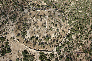
Khirbet Qeiyafa is the site of an ancient city overlooking the Elah Valley
. The ruins of the fortress were uncovered in 2007, near the Israel
i city of Beit Shemesh, 20 miles from Jerusalem. It covers nearly six acres and is encircled by a 700-meter long city wall constructed of stones weighing up to eight tons each. The fortress was situated at a key location in the Kingdom of Judah
along the main road from Philistia
and the coastal plain
to the eastern hill country. Archaeologists suggest that it may have been the biblical city of Sha'arayim or Neta'im.
, Elah Fortress, derives from the location of the site on the northern bank of Nahal Elah, one of six brooks that flow from the Judean mountains
to the coastal plain.
 The Elah Fortress lies just inside a north-south ridge of hills separating Philistia and Gath to the west from Judea to the east. The ridge also includes the site currently identified as Tel Azekah
. Past this ridge is a series of connecting valleys between two parallel groups of hills. Tel Sokho
lies on the southern ridge with Tel Adullam
behind it. The Elah Fortress is situated on the northern ridge, overlooking several valleys with a clear view of the Judean Mountains. Behind it to the northeast is Tel Yarmut. From the topography, archaeologists believe this was the location of the cities of Adullam, Sokho, Azekah and Yarmut cited in . These valleys formed the border between Philistia and Judea.
who reported the presence of a village on the hilltop. In 1875, British surveyors noted only stone heaps. In 1932, Dimitri Baramki, reported the site to hold a 35 square meter watchtower associated with Khirbet Quleidiya (Horvat Qolad), a few hundred meters east. The site was mostly neglected in the 20th century and not mentioned by leading scholars. Yehuda Dagan conducted more intense surveys in the 1990s and documented the visible remains. The site raised curiosity in 2005 when Saar Ganor discovered impressive Iron Age
structures under the remnants.
Excavations at Khirbet Qeiyafa began in 2007, directed by Yosef Garfinkel
of the Hebrew University and Saar Ganor
of the Israel Antiquities Authority
, and continued in 2008. Nearly 600 square meters of an Iron Age IIA city were unearthed. Based on pottery styles and two burned olive pits tested for carbon-14 at Oxford University, Garfinkel and Ganor have dated the site to 1050–970 BC, although Israel Finkelstein
contends evidence points to habitation between 1050 and 915 BC.
The initial excavation by Ganor and Garfinklel took place from August 12 to 26, 2007 on behalf of the Hebrew University of Jerusalem
Institute of Archaeology. In their preliminary report at the annual ASOR
conference on November 15, they presented a theory that the site was the Biblical Azekah
, which until then had been exclusively associated with Tell Zakariya. In 2008, after the discovery of a second gate, they identified the site as the biblical Sha'arayim ("two gates" in Hebrew).
In 2010, Gershon Galil
of the University of Haifa
identified Khirbet Qeiyafa as the “Neta’im” of , due to its proximity to Khirbet Ğudrayathe (biblical Gederah). The inhabitants of both cities were said to be "potters" and "in the King’s service", a description that is consistent with the archeological discoveries at that site.
Yehuda Dagan of the Israel Antiquities Authority also disagrees with the identification as Sha'arayim. Dagan believes the ancient Philistine retreat route after their defeat in the battle at the Valley of Elah , more likely identifies Sha'arayim with the remains of Khirbet esh-Shari'a. Dagan proposes that Khirbet Qeiyafa be identified with biblical Adithaim .
The fortifications at Khirbet Qeiyafa predate those of contemporary Lachish
, Beersheba
, Arad
, and Timnah
. All these sites have yielded pottery dated to early Iron Age II. The parallel valley to the north, mentioned in Samuel
I, runs from the Philistine city of Ekron
to Tel Beit Shemesh. The city gate of the Elah Fortress faces west with a path down to the road leading to the sea, and was thus named "Gath Gate" or "Sea Gate." The 23 dunams (5.7 acre) site is surrounded by a casement
wall and fortifications. The top layer of the fortress shows that the fortifications were renewed in the Hellenistic period.
Garfinkel suggests that Khirbet Qeiyafa was a Judean city inhabited by 500–600 people during the reign of David
and Solomon
. Based on pottery finds at Qeiyafa and Gath, archaeologists believe the sites belonged to two distinct ethnic groups. "The finds have not yet established who the residents were," says Aren Maeir
, a Bar Ilan University archaeologist digging at Gath. "It will become more clear if, for example, evidence of the local diet is found. Excavations have shown that Philistines ate dogs and pigs, while Israelites did not. The nature of the ceramic shards found at the site suggest residents might have been neither Israelites nor Philistines but members of a third, forgotten people." Evidence that the city was not Philistine comes from the private houses that abut the city wall, an arrangement that was not used in Philistine cities. There is also evidence of equipment for baking flat bread and hundreds of bones from goats, cattle, sheep, and fish. Significantly, no pig bones have been uncovered, suggesting that the city was not Philistine. Nadav Na'aman of Tel Aviv University nevertheless associates it with Philistine Gath, citing the necessity for further excavations as well as evidence from Bet Shemesh whose inhabitants also avoided eating pork, yet were associated with Ekron.
and Gezer
, formed by a casemate
(a pair of walls with a chamber in between). At the center of the upper city is a large rectangular enclosure with spacious rooms on the south, equivalent to similar enclosures found at royal cities such as Samaria
, Lachish
, and Ramat Rachel
. On the southern slope, outside the city, there are Iron Age
rock-cut tombs.
Area "A" extended 5x5 metres & consists of two major layers: Hellenistic
above, and Iron Age II below. Area "B" contains four squares, about 2.5 metres deep from top-soil to bedrock, and also features both Hellenistic and Iron Age layers. Surveys on the surface have also revealed sherds from the early and middle Bronze Ages, as well as from the Persian, Roman, Byzantine, early Islamic, Mameluke and Ottoman periods.
The Hellenistic/upper portion of the wall was built with small rocks atop the Iron-II lower portion, consisting of big boulders in a casemate
design. Part of a structure identified as a city gate was uncovered, and some of the rocks where the wall meets this gate are estimated to weigh 3 to 5 ton
s. The lower phase was built of especially large stones, 1–3 meters long, and the heaviest of them weigh 3–5 tons. Atop these stones is a thin wall, c. 1.5 meters thick; small and medium size fieldstones were used in its construction. These two fortification phases rise to a height of 2–3 meters and standout at a distance, evidence of the great effort that was invested in fortifying the place.
, a trapezoid
-shaped pottery sherd
with five lines of text, was discovered during excavations at the site in 2008.
Although the writing on the ostracon is poorly preserved and difficult to read, Gershon Galil
of Haifa University proposed the following translation:
On January 10, 2010, the University of Haifa issued a press release stating that the text was a social statement relating to slaves, widows and orphans. According to the document: "It uses verbs that were characteristic of Hebrew, such as `asah ("did") and `avad ("worked"), which were rarely used in other regional languages. Particular words that appear in the text, such as almanah ("widow") are specific to Hebrew and are written differently in other local languages. The content itself was also unfamiliar to all the cultures in the region besides the Hebrew society: The present inscription provides social elements similar to those found in the biblical prophecies and very different from prophecies written by other cultures postulating glorification of the gods and taking care of their physical needs."
Other readings are possible, and the official excavation report presented many possible reconstructions of the letters without attempting a translation. The inscription is written left to right in a script which is probably Early Alphabetic/Proto Phoenician, though Rollston and Demsky consider that it might be written vertically. Early Alphabetic differs from old Hebrew script and its immediate ancestor. Rollston also disputes the claim that the language is Hebrew, arguing that the words alleged to be indicative of Hebrew either appear in other languages or don't actually appear in the inscription. Millard believes the language of the inscription is Hebrew, Canaanite, Phoenician or Moabite and it most likely consists of a list of names written by someone unused to writing. Hebrew University archaeologist Amihai Mazar
said the inscription was very important, as it is the longest Proto-Canaanite text ever found.
In 2010, the ostracon was placed on display in Iron Age gallery of the Israel Museum
in Jerusalem.
Valley of Elah
The Valley of Elah, "the valley of the oak or terebinth" , best known as the place described in the Bible where the Israelites were encamped when David fought Goliath . It was near Azekah and Socho...
. The ruins of the fortress were uncovered in 2007, near the Israel
Israel
The State of Israel is a parliamentary republic located in the Middle East, along the eastern shore of the Mediterranean Sea...
i city of Beit Shemesh, 20 miles from Jerusalem. It covers nearly six acres and is encircled by a 700-meter long city wall constructed of stones weighing up to eight tons each. The fortress was situated at a key location in the Kingdom of Judah
Kingdom of Judah
The Kingdom of Judah was a Jewish state established in the Southern Levant during the Iron Age. It is often referred to as the "Southern Kingdom" to distinguish it from the northern Kingdom of Israel....
along the main road from Philistia
Philistines
Philistines , Pleshet or Peleset, were a people who occupied the southern coast of Canaan at the beginning of the Iron Age . According to the Bible, they ruled the five city-states of Gaza, Askelon, Ashdod, Ekron and Gath, from the Wadi Gaza in the south to the Yarqon River in the north, but with...
and the coastal plain
Shephelah
The Shephelah is a designation usually applied to the region in south-central Israel of 10-15 km of low hills between the central Mount Hebron and the coastal plains of Philistia within the area of the Judea, at an altitude of 120-450 metres above sea level. The area is fertile, and a temperate...
to the eastern hill country. Archaeologists suggest that it may have been the biblical city of Sha'arayim or Neta'im.
Name
The meaning of the Arabic name of the site, Khirbet Qeiyafa, is uncertain. Scholars suggest it may mean "the place with a wide view." Local Bedouin refer to the site as Khirbet Daoud, or David's ruin. The modern Hebrew nameHebrew name
Hebrew names are names that have a Hebrew language origin, classically from the Hebrew Bible. They are mostly used by people living in Jewish or Christian parts of the world, but some are also adapted to the Islamic world, particularly if a Hebrew name is mentioned in the Qur'an. When...
, Elah Fortress, derives from the location of the site on the northern bank of Nahal Elah, one of six brooks that flow from the Judean mountains
Judean Mountains
The Judaean Mountains, ;, also Judaean Hills and Hebron Hills is a mountain range in Israel and the West Bank where Jerusalem and several other biblical cities are located. The mountains reach a height of 1,000 m.-Geography:...
to the coastal plain.
Geography
Azekah
Azekah was a town in the Shephelah guarding the upper reaches of the Valley of Elah, about 26 km northwest of Hebron. It has been identified with biblical Azeka.-Biblical history:...
. Past this ridge is a series of connecting valleys between two parallel groups of hills. Tel Sokho
Sokho
Sokho is the name of two towns in biblical Judah....
lies on the southern ridge with Tel Adullam
Adullam
Adullam is a region of Israel near the Valley of Elah , west of Gush Etzion. The villages of Aderet, Neve Michael/Roglit, and Aviezer are located here. In the 1950s there were plans to set up Adullam as a formal political/economic region, on the model of Lachish, but the plans were not carried out...
behind it. The Elah Fortress is situated on the northern ridge, overlooking several valleys with a clear view of the Judean Mountains. Behind it to the northeast is Tel Yarmut. From the topography, archaeologists believe this was the location of the cities of Adullam, Sokho, Azekah and Yarmut cited in . These valleys formed the border between Philistia and Judea.
Site and excavation history
The site of Khirbet Qeiyafa was surveyed in the 1860s by Victor GuérinVictor Guérin
Victor Guérin was a French intellectual, explorer and amateur archaeologist. He published books describing the geography, archeology and history of the areas he explored, which included Greece, Asia Minor, North Africa, Syria and Palestine.-Biography:From 1840, Guerin was a professor of rhetoric...
who reported the presence of a village on the hilltop. In 1875, British surveyors noted only stone heaps. In 1932, Dimitri Baramki, reported the site to hold a 35 square meter watchtower associated with Khirbet Quleidiya (Horvat Qolad), a few hundred meters east. The site was mostly neglected in the 20th century and not mentioned by leading scholars. Yehuda Dagan conducted more intense surveys in the 1990s and documented the visible remains. The site raised curiosity in 2005 when Saar Ganor discovered impressive Iron Age
Iron Age
The Iron Age is the archaeological period generally occurring after the Bronze Age, marked by the prevalent use of iron. The early period of the age is characterized by the widespread use of iron or steel. The adoption of such material coincided with other changes in society, including differing...
structures under the remnants.
Excavations at Khirbet Qeiyafa began in 2007, directed by Yosef Garfinkel
Yosef Garfinkel
Yosef Garfinkel is a professor of Prehistoric Archaeology and of Archaeology of the Biblical Period at the Hebrew University of Jerusalem.-Biography:...
of the Hebrew University and Saar Ganor
Saar Ganor
Saar Ganor is an Israeli archaeologist. He is the director, along with Yosef Garfinkel, of excavations at Khirbet Qeiyafa, thought to be Biblical Sha'arayim. He is inspector for the Israel Antiquities Authority and a lecturer at the Hebrew University of Jerusalem.Ganor noticed the unusual scale...
of the Israel Antiquities Authority
Israel Antiquities Authority
The Israel Antiquities Authority is an independent Israeli governmental authority responsible for enforcing the 1978 Law of Antiquities. The IAA regulates excavation and conservation, and promotes research...
, and continued in 2008. Nearly 600 square meters of an Iron Age IIA city were unearthed. Based on pottery styles and two burned olive pits tested for carbon-14 at Oxford University, Garfinkel and Ganor have dated the site to 1050–970 BC, although Israel Finkelstein
Israel Finkelstein
Israel Finkelstein is an Israeli archaeologist and academic. He is currently the Jacob M. Alkow Professor of the Archaeology of Israel in the Bronze Age and Iron Ages at Tel Aviv University and is also the co-director of excavations at Megiddo in northern Israel...
contends evidence points to habitation between 1050 and 915 BC.
The initial excavation by Ganor and Garfinklel took place from August 12 to 26, 2007 on behalf of the Hebrew University of Jerusalem
Hebrew University of Jerusalem
The Hebrew University of Jerusalem ; ; abbreviated HUJI) is Israel's second-oldest university, after the Technion – Israel Institute of Technology. The Hebrew University has three campuses in Jerusalem and one in Rehovot. The world's largest Jewish studies library is located on its Edmond J...
Institute of Archaeology. In their preliminary report at the annual ASOR
American Schools of Oriental Research
The American Schools of Oriental Research, founded in 1900, supports and encourages the study of the peoples and cultures of the Near East, from the earliest times to the present. It is apolitical and has no religious affiliation...
conference on November 15, they presented a theory that the site was the Biblical Azekah
Azekah
Azekah was a town in the Shephelah guarding the upper reaches of the Valley of Elah, about 26 km northwest of Hebron. It has been identified with biblical Azeka.-Biblical history:...
, which until then had been exclusively associated with Tell Zakariya. In 2008, after the discovery of a second gate, they identified the site as the biblical Sha'arayim ("two gates" in Hebrew).
Dating and identification
Discoveries at Khirbet Qeiyafa are significant to the debate about the veracity of the Biblical account of the United Monarchy at the beginning of Iron Age II. As no archaeological finds were found that could corroborate claims of the existence of a magnificent biblical kingdom, various scholars have advanced the opinion that the kingdom was no more than a small tribal entity. Garfinkel, while admitting that the debate cannot "be answered by the Qeiyafa excavations", is of the opinion that "what is clear, however, is that the kingdom of Judah existed already as a centrally organized state in the tenth century B.C.E"In 2010, Gershon Galil
Gershon Galil
Gershon Galil is Professor of Biblical Studies and Ancient History and former chair of the Department of Jewish History at the University of Haifa, Mount Carmel, Haifa, Israel. He received his doctorate at Hebrew University in Jerusalem. His work, The Chronology of the Kings of Israel and Judah,...
of the University of Haifa
University of Haifa
The University of Haifa is a university in Haifa, Israel.The University of Haifa was founded in 1963 by Haifa mayor Abba Hushi, to operate under the academic auspices of the Hebrew University of Jerusalem....
identified Khirbet Qeiyafa as the “Neta’im” of , due to its proximity to Khirbet Ğudrayathe (biblical Gederah). The inhabitants of both cities were said to be "potters" and "in the King’s service", a description that is consistent with the archeological discoveries at that site.
Yehuda Dagan of the Israel Antiquities Authority also disagrees with the identification as Sha'arayim. Dagan believes the ancient Philistine retreat route after their defeat in the battle at the Valley of Elah , more likely identifies Sha'arayim with the remains of Khirbet esh-Shari'a. Dagan proposes that Khirbet Qeiyafa be identified with biblical Adithaim .
The fortifications at Khirbet Qeiyafa predate those of contemporary Lachish
Lachish
Lachish was an ancient Near East town located at the site of modern Tell ed-Duweir in the Shephelah, a region between Mount Hebron and the maritime plain of Philistia . The town was first mentioned in the Amarna letters as Lakisha-Lakiša...
, Beersheba
Beersheba
Beersheba is the largest city in the Negev desert of southern Israel. Often referred to as the "Capital of the Negev", it is the seventh-largest city in Israel with a population of 194,300....
, Arad
Tel Arad
Tel Arad or 'old' Arad is located west of the Dead Sea, about 10 km west of modern Arad in an area surrounded by mountain ridges which is known as the Arad Plain. The site is divided into a lower city and an upper hill which holds the only ever discovered 'House of Yahweh' in the land of...
, and Timnah
Timnah
Timnath or Timnah was a Philistine city in Canaan that is mentioned in the Hebrew Bible in . It has been identified with Tel Batash , a tel located in the Sorek Valley, near moshav Tal Shahar, Israel....
. All these sites have yielded pottery dated to early Iron Age II. The parallel valley to the north, mentioned in Samuel
Samuel
Samuel is a leader of ancient Israel in the Books of Samuel in the Hebrew Bible. He is also known as a prophet and is mentioned in the Qur'an....
I, runs from the Philistine city of Ekron
Ekron
The city of Ekron , was one of the five cities of the famed Philistine pentapolis, located in southwestern Canaan. Ekron lies 35 kilometers west of Jerusalem, and 18 kilometers north of ancient Gath, on the eastern edge of Israel's coastal plain.-History:...
to Tel Beit Shemesh. The city gate of the Elah Fortress faces west with a path down to the road leading to the sea, and was thus named "Gath Gate" or "Sea Gate." The 23 dunams (5.7 acre) site is surrounded by a casement
Casemate
A casemate, sometimes rendered casement, is a fortified gun emplacement or armored structure from which guns are fired. originally a vaulted chamber in a fortress.-Origin of the term:...
wall and fortifications. The top layer of the fortress shows that the fortifications were renewed in the Hellenistic period.
Garfinkel suggests that Khirbet Qeiyafa was a Judean city inhabited by 500–600 people during the reign of David
David
David was the second king of the united Kingdom of Israel according to the Hebrew Bible and, according to the Gospels of Matthew and Luke, an ancestor of Jesus Christ through both Saint Joseph and Mary...
and Solomon
Solomon
Solomon , according to the Book of Kings and the Book of Chronicles, a King of Israel and according to the Talmud one of the 48 prophets, is identified as the son of David, also called Jedidiah in 2 Samuel 12:25, and is described as the third king of the United Monarchy, and the final king before...
. Based on pottery finds at Qeiyafa and Gath, archaeologists believe the sites belonged to two distinct ethnic groups. "The finds have not yet established who the residents were," says Aren Maeir
Aren Maeir
Aren Maeir is a professor at Bar Ilan University and director of the Tell es-Safi/Gath Archaeological Project . Born in 1958 in Rochester, New York, USA, he moved to Israel in 1969 and has lived there since...
, a Bar Ilan University archaeologist digging at Gath. "It will become more clear if, for example, evidence of the local diet is found. Excavations have shown that Philistines ate dogs and pigs, while Israelites did not. The nature of the ceramic shards found at the site suggest residents might have been neither Israelites nor Philistines but members of a third, forgotten people." Evidence that the city was not Philistine comes from the private houses that abut the city wall, an arrangement that was not used in Philistine cities. There is also evidence of equipment for baking flat bread and hundreds of bones from goats, cattle, sheep, and fish. Significantly, no pig bones have been uncovered, suggesting that the city was not Philistine. Nadav Na'aman of Tel Aviv University nevertheless associates it with Philistine Gath, citing the necessity for further excavations as well as evidence from Bet Shemesh whose inhabitants also avoided eating pork, yet were associated with Ekron.
Archaeological finds
The site consists of a lower city of about 10 hectares and an upper city of about 3 hectares (7.4 acre) surrounded by a massive defensive wall ranging from 2–4 m (6.6–13.1 ) tall. The walls are built in the same manner as the walls of HazorHazor
Hazor is the name of several places in the biblical and modern Israel:Biblical locations:* Tel Hazor, site of an ancient fortified city in the Upper Galilee, among the most important Caananite towns, and the largest ancient ruin in modern Israel and UNESCO World Heritage Site.* Hazor, A town in...
and Gezer
Gezer
Gezer was a Canaanite city-state and biblical town in ancient Israel. Tel Gezer , an archaeological site midway between Jerusalem and Tel Aviv, is now an Israeli national park....
, formed by a casemate
Casemate
A casemate, sometimes rendered casement, is a fortified gun emplacement or armored structure from which guns are fired. originally a vaulted chamber in a fortress.-Origin of the term:...
(a pair of walls with a chamber in between). At the center of the upper city is a large rectangular enclosure with spacious rooms on the south, equivalent to similar enclosures found at royal cities such as Samaria
Samaria
Samaria, or the Shomron is a term used for a mountainous region roughly corresponding to the northern part of the West Bank.- Etymology :...
, Lachish
Lachish
Lachish was an ancient Near East town located at the site of modern Tell ed-Duweir in the Shephelah, a region between Mount Hebron and the maritime plain of Philistia . The town was first mentioned in the Amarna letters as Lakisha-Lakiša...
, and Ramat Rachel
Ramat Rachel
Ramat Rachel is a kibbutz located south of Jerusalem in Israel, as an enclave within Jerusalem's municipal boundaries. Overlooking Bethlehem and Rachel's Tomb and situated within the Green Line, it falls under the jurisdiction of Mateh Yehuda Regional Council...
. On the southern slope, outside the city, there are Iron Age
Iron Age
The Iron Age is the archaeological period generally occurring after the Bronze Age, marked by the prevalent use of iron. The early period of the age is characterized by the widespread use of iron or steel. The adoption of such material coincided with other changes in society, including differing...
rock-cut tombs.
Area "A" extended 5x5 metres & consists of two major layers: Hellenistic
Hellenistic period
The Hellenistic period or Hellenistic era describes the time which followed the conquests of Alexander the Great. It was so named by the historian J. G. Droysen. During this time, Greek cultural influence and power was at its zenith in Europe and Asia...
above, and Iron Age II below. Area "B" contains four squares, about 2.5 metres deep from top-soil to bedrock, and also features both Hellenistic and Iron Age layers. Surveys on the surface have also revealed sherds from the early and middle Bronze Ages, as well as from the Persian, Roman, Byzantine, early Islamic, Mameluke and Ottoman periods.
The Hellenistic/upper portion of the wall was built with small rocks atop the Iron-II lower portion, consisting of big boulders in a casemate
Casemate
A casemate, sometimes rendered casement, is a fortified gun emplacement or armored structure from which guns are fired. originally a vaulted chamber in a fortress.-Origin of the term:...
design. Part of a structure identified as a city gate was uncovered, and some of the rocks where the wall meets this gate are estimated to weigh 3 to 5 ton
Ton
The ton is a unit of measure. It has a long history and has acquired a number of meanings and uses over the years. It is used principally as a unit of weight, and as a unit of volume. It can also be used as a measure of energy, for truck classification, or as a colloquial term.It is derived from...
s. The lower phase was built of especially large stones, 1–3 meters long, and the heaviest of them weigh 3–5 tons. Atop these stones is a thin wall, c. 1.5 meters thick; small and medium size fieldstones were used in its construction. These two fortification phases rise to a height of 2–3 meters and standout at a distance, evidence of the great effort that was invested in fortifying the place.
Khirbet Qeiyafa inscription
A 15 centimetre ostraconOstracon
An ostracon is a piece of pottery , usually broken off from a vase or other earthenware vessel. In archaeology, ostraca may contain scratched-in words or other forms of writing which may give clues as to the time when the piece was in use...
, a trapezoid
Trapezoid
In Euclidean geometry, a convex quadrilateral with one pair of parallel sides is referred to as a trapezoid in American English and as a trapezium in English outside North America. A trapezoid with vertices ABCD is denoted...
-shaped pottery sherd
Sherd
In archaeology, a sherd is commonly a historic or prehistoric fragment of pottery, although the term is occasionally used to refer to fragments of stone and glass vessels as well....
with five lines of text, was discovered during excavations at the site in 2008.
Although the writing on the ostracon is poorly preserved and difficult to read, Gershon Galil
Gershon Galil
Gershon Galil is Professor of Biblical Studies and Ancient History and former chair of the Department of Jewish History at the University of Haifa, Mount Carmel, Haifa, Israel. He received his doctorate at Hebrew University in Jerusalem. His work, The Chronology of the Kings of Israel and Judah,...
of Haifa University proposed the following translation:
- 1 you shall not do [it], but worship (the god) [El]
- 2 Judge the sla[ve] and the wid[ow] / Judge the orph[an]
- 3 [and] the stranger. [Pl]ead for the infant / plead for the po[or and]
- 4 the widow. Rehabilitate [the poor] at the hands of the king
- 5 Protect the po[or and] the slave / [supp]ort the stranger.
On January 10, 2010, the University of Haifa issued a press release stating that the text was a social statement relating to slaves, widows and orphans. According to the document: "It uses verbs that were characteristic of Hebrew, such as `asah ("did") and `avad ("worked"), which were rarely used in other regional languages. Particular words that appear in the text, such as almanah ("widow") are specific to Hebrew and are written differently in other local languages. The content itself was also unfamiliar to all the cultures in the region besides the Hebrew society: The present inscription provides social elements similar to those found in the biblical prophecies and very different from prophecies written by other cultures postulating glorification of the gods and taking care of their physical needs."
Other readings are possible, and the official excavation report presented many possible reconstructions of the letters without attempting a translation. The inscription is written left to right in a script which is probably Early Alphabetic/Proto Phoenician, though Rollston and Demsky consider that it might be written vertically. Early Alphabetic differs from old Hebrew script and its immediate ancestor. Rollston also disputes the claim that the language is Hebrew, arguing that the words alleged to be indicative of Hebrew either appear in other languages or don't actually appear in the inscription. Millard believes the language of the inscription is Hebrew, Canaanite, Phoenician or Moabite and it most likely consists of a list of names written by someone unused to writing. Hebrew University archaeologist Amihai Mazar
Amihai Mazar
Amihai "Ami" Mazar is an Israeli archaeologist. Born in Haifa, Israel , he is currently Professor at the Institute of Archaeology of the Hebrew University of Jerusalem, holding the Eleazer Sukenik Chair in the Archaeology of Israel.Mazar has directed archaeological excavations at a number of...
said the inscription was very important, as it is the longest Proto-Canaanite text ever found.
In 2010, the ostracon was placed on display in Iron Age gallery of the Israel Museum
Israel Museum
The Israel Museum, Jerusalem was founded in 1965 as Israel's national museum. It is situated on a hill in the Givat Ram neighborhood of Jerusalem, near the Bible Lands Museum, the Knesset, the Israeli Supreme Court, and the Hebrew University of Jerusalem....
in Jerusalem.
See also
- Biblical archaeologyBiblical archaeologyFor the movement associated with William F. Albright and also known as biblical archaeology, see Biblical archaeology school. For the interpretation of biblical archaeology in relation to biblical historicity, see The Bible and history....
- Biblical Minimalism
- Archaeology of IsraelArchaeology of IsraelThe archaeology of Israel is the study of the archaeology of Israel, stretching from prehistory through three millennia of documented history. The ancient Land of Israel was a geographical bridge between the political and cultural centers of Mesopotamia and Egypt...
- KhirbaKhirbaKhirba is an Arabic term that refers to a secondary or satellite village on the outskirts of an agricultural village. The khirba was used intermittently during the year, primarily during the plowing or harvest seasons....