

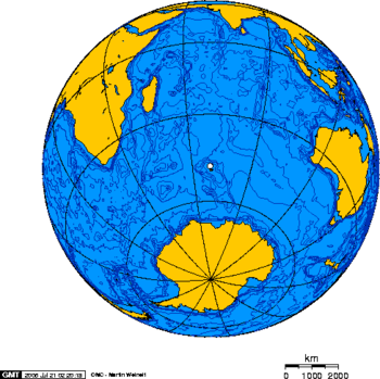
Kerguelen Plateau
Encyclopedia
Large igneous province
A Large Igneous Province is an extremely large accumulation of igneous rocks—intrusive, extrusive, or both—in the earth's crust...
(LIP), also the microcontinent and submerged continent
Submerged continent
A submerged continent is a continental mass, extensive in size, but mainly undersea. The terminology is used by some paleogeologists and geographers in reference to some land masses.The two main examples in this class are the Kerguelen Plateau and Zealandia...
in the southern Indian Ocean
Indian Ocean
The Indian Ocean is the third largest of the world's oceanic divisions, covering approximately 20% of the water on the Earth's surface. It is bounded on the north by the Indian Subcontinent and Arabian Peninsula ; on the west by eastern Africa; on the east by Indochina, the Sunda Islands, and...
. It lies about 3,000 km to the southwest of Australia
Australia
Australia , officially the Commonwealth of Australia, is a country in the Southern Hemisphere comprising the mainland of the Australian continent, the island of Tasmania, and numerous smaller islands in the Indian and Pacific Oceans. It is the world's sixth-largest country by total area...
and is nearly three times the size of Japan
Japan
Japan is an island nation in East Asia. Located in the Pacific Ocean, it lies to the east of the Sea of Japan, China, North Korea, South Korea and Russia, stretching from the Sea of Okhotsk in the north to the East China Sea and Taiwan in the south...
. The plateau
Plateau
In geology and earth science, a plateau , also called a high plain or tableland, is an area of highland, usually consisting of relatively flat terrain. A highly eroded plateau is called a dissected plateau...
extends for more than 2,200 km in a northwest-southeast direction and lies in deep water.
The plateau was produced by the Kerguelen hotspot
Kerguelen hotspot
The Kerguelen hotspot is a volcanic hotspot at the Kerguelen Plateau in the Southern Indian Ocean. The Kerguelen hotspot has produced basaltic lava for about 130 million years and has also produced the Kerguelen Islands, Heard Island, the McDonald Islands, and the Ninetyeast Ridge....
, starting with or following the breakup of Gondwana
Gondwana
In paleogeography, Gondwana , originally Gondwanaland, was the southernmost of two supercontinents that later became parts of the Pangaea supercontinent. It existed from approximately 510 to 180 million years ago . Gondwana is believed to have sutured between ca. 570 and 510 Mya,...
about 130 million years ago. There is a small portion of the plateau that breaks sea level
Sea level
Mean sea level is a measure of the average height of the ocean's surface ; used as a standard in reckoning land elevation...
, forming the Kerguelen Islands
Kerguelen Islands
The Kerguelen Islands , also known as the Desolation Islands, are a group of islands in the southern Indian Ocean constituting the emerged part of the otherwise submerged Kerguelen Plateau. The islands, along with Adélie Land, the Crozet Islands and the Amsterdam and Saint Paul Islands are part of...
, Heard Island and McDonald Islands
Heard Island and McDonald Islands
The Heard Island and McDonald Islands are an Australian external territory and volcanic group of barren Antarctic islands, about two-thirds of the way from Madagascar to Antarctica. The group's overall size is in area and it has of coastline...
. Intermittent volcanism continues on Heard and McDonald islands.
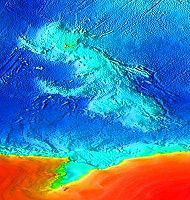
Geographical extent
Symmetrically located across the Indian Ocean ridge and due west of Australia, is the Broken Ridge underwater volcanic plateauVolcanic plateau
A volcanic plateau is a plateau produced by volcanic activity. There are two main types: lava plateaus and pyroclastic plateaus.-Lava plateau:...
which was at one time contiguous with the Kerguelen Plateau prior to rifting by the mid-ocean ridge
Mid-ocean ridge
A mid-ocean ridge is a general term for an underwater mountain system that consists of various mountain ranges , typically having a valley known as a rift running along its spine, formed by plate tectonics. This type of oceanic ridge is characteristic of what is known as an oceanic spreading...
.
To the north of Broken Ridge lies the linear Ninety East Ridge
Ninety East Ridge
The Ninety East Ridge is a linear, aseismic, age-progressive seamount chain in the Indian Ocean and is named for its near-parallel strike along the 90th meridian...
which continues almost due north into the Bay of Bengal
Bay of Bengal
The Bay of Bengal , the largest bay in the world, forms the northeastern part of the Indian Ocean. It resembles a triangle in shape, and is bordered mostly by the Eastern Coast of India, southern coast of Bangladesh and Sri Lanka to the west and Burma and the Andaman and Nicobar Islands to the...
and is considered to be a hotspot
Hotspot (geology)
The places known as hotspots or hot spots in geology are volcanic regions thought to be fed by underlying mantle that is anomalously hot compared with the mantle elsewhere. They may be on, near to, or far from tectonic plate boundaries. There are two hypotheses to explain them...
track.
Kerguelen microcontinent
The Kerguelen Plateau was formed starting 110 million years ago from a series of large volcanic eruptions. The presence of soil layers in the basalt with included charcoalCharcoal
Charcoal is the dark grey residue consisting of carbon, and any remaining ash, obtained by removing water and other volatile constituents from animal and vegetation substances. Charcoal is usually produced by slow pyrolysis, the heating of wood or other substances in the absence of oxygen...
and conglomerate
Conglomerate (geology)
A conglomerate is a rock consisting of individual clasts within a finer-grained matrix that have become cemented together. Conglomerates are sedimentary rocks consisting of rounded fragments and are thus differentiated from breccias, which consist of angular clasts...
fragments of gneiss
Gneiss
Gneiss is a common and widely distributed type of rock formed by high-grade regional metamorphic processes from pre-existing formations that were originally either igneous or sedimentary rocks.-Etymology:...
indicate that much of the plateau was above sea level as what is termed a microcontinent for three periods between 100 million years ago and 20 million years ago.
The so-called Kerguelen microcontinent may have been covered by dense conifer forest in the mid-Cretaceous
Cretaceous
The Cretaceous , derived from the Latin "creta" , usually abbreviated K for its German translation Kreide , is a geologic period and system from circa to million years ago. In the geologic timescale, the Cretaceous follows the Jurassic period and is followed by the Paleogene period of the...
. It finally sank 20 million years ago and is now 1 – below sea level. It has sedimentary rock
Sedimentary rock
Sedimentary rock are types of rock that are formed by the deposition of material at the Earth's surface and within bodies of water. Sedimentation is the collective name for processes that cause mineral and/or organic particles to settle and accumulate or minerals to precipitate from a solution....
s similar to the ones found in Australia
Australia
Australia , officially the Commonwealth of Australia, is a country in the Southern Hemisphere comprising the mainland of the Australian continent, the island of Tasmania, and numerous smaller islands in the Indian and Pacific Oceans. It is the world's sixth-largest country by total area...
and India
India
India , officially the Republic of India , is a country in South Asia. It is the seventh-largest country by geographical area, the second-most populous country with over 1.2 billion people, and the most populous democracy in the world...
, suggesting they were once connected.