

Kefalonia
Encyclopedia
The island of Cephalonia, also known as Kefalonia, Cephallenia, Cephallonia, Kefallinia, or Kefallonia (Ancient Greek: Κεφαλληνία; Modern Greek
: Κεφαλονιά or Κεφαλλονιά; ), is the largest of the Ionian Islands
in western Greece
, with an area of 781 square kilometres (301.5 sq mi). It is also a separate regional unit of the Ionian Islands region, and the only municipality
of the regional unit. The capital of Cephalonia is Argostoli
.
is the second major settlement, and the two towns together account for almost two-thirds of the prefecture's population.
Cephalonia is in the heart of an earthquake
zone, and dozens of minor or unrecorded tremors occur each year. In 1953, a massive earthquake almost destroyed all settlement on the island, leaving only Fiscardo in the north untouched.
Among important natural features are the Melissani and the Drogarati caves.
, with an elevation of 1628m; to the west-northwest are the Paliki
mountains, where Lixouri
is found, with other mountains including Gerania
and Agia Dynati
. The top of Mount Ainos is covered with Abies cephalonica trees and is a natural park.
were common during the 1990s and the early 2000s and still pose a major threat to the population.
and olive growing, with the remainder largely composed of grain and vegetables. Most vegetable production takes place on the plains, which cover less than 15% of the island, most of which is rugged and mountainous, suitable only for goats. Less than a quarter of the island's land is arable.
Until the 1970s most Cephalonians lived in rural areas, while today the urban population accounts for two-thirds, with the other third in rural towns and villages close to farmland.
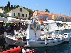 There are five harbours and ports in the prefecture: four main harbours on the island, Same
or Sami, and a major port with links to Patras
and Ithaca
. Poros, in the south, has ferry routes to Kyllini; Argostoli, in the west, is the largest port, for local boats and ferries to Zante
and regularly to Lixouri; Fiscardo
, in the north, has links to Lefkas
and Ithaca. There is room for about 100 small boats in Argostoli, where the port stretches 1 kilometre around the bay, while Lixouri is situated 4 km across the bay from Argostoli, on the Lixouri peninsula. There is a road connection to the rest of the island, but driving from Lixouri to Argostoli involves a 30 km detour.
population which nest at Kaminia beach under the watchful protection of the Sea Turtle
Protection society.
of the regional unit. The seat of administration is Argostoli
, the main town of the island. As a part of the 2011 Kallikratis government reform, the regional unit Kefallinia was created out of part of the former Kefalonia and Ithaca Prefecture
. At the same reform, the current municipality Cephalonia was created out of the 8 former municipalities:
, who helped Amphitryon
of Mycenae
in a war against the Taphians
and Teleboans. He was awarded with the island of Same
, which thereafter came to be known as Cephallenia.
Cephalonia has also been suggested as the Homeric Ithaca
, the home of Odysseus
, rather than the smaller island bearing this name today.
Robert Bittlestone, in his book Odysseus Unbound
, has suggested that Paliki
, now a peninsula of Cephalonia, was a separate island during the late Bronze Age
, and it may be this that Homer was referring to when he described Ithaca. A project starting in the Summer of 2007, and lasting three years examines this possibility.
Cephalonia is also referenced in relation to the goddess Britomartis
, as the location where she is said to have 'received divine honours from the inhabitants under the name of Laphria
'.
by the Irish Institute at Athens
has discovered dozens of sites, with dates ranging from the Palaeolithic to the Venetian
period.
From archaeological point of view Cephalonia is an extremely interesting island.
Archaeological findings go back to 40,000 BP. Without any doubt the island's most important era is the Mycenaean era
from approx. 1500-1100 B.C. The archaeological museum in Cephalonia’s capital Argostoli – although small – is regarded as the most important museum in Greece for its exhibits from this era. http://www.leepka.gr/mouseioarg.php
The most important archaeological discovery in Cephalonia (and in Greece) of the past twenty years was the discovery in 1991 of the Mycenaean tholos
tomb at the outskirts of the village Tzanata
, near Poros, Kefalonia
in south-eastern Cephalonia (Municipality of Elios-Pronni) in a lovely setting of olive trees
, cypresses and oaks. The tomb was erected around 1300 B.C. Kings and high ranked officials were buried in these tholos
tombs during the Mycenaean period. It is the biggest tholos-tomb yet found in north-western Greece. The tomb was excavated by the archaeologist Lazaros Kolonas. The size of the tomb, the nature of the burial offerings found there and its well-chosen position point to the existence of an important Mycenaean town in the vicinity.
In late 2006, a Roman grave complex was uncovered as excavations took place for the construction of a new hotel in Fiscardo. The remains date to the period between the 2nd century B.C. and the 4th century A.D. Archaeologists described this as the most important find of its kind ever made in the Ionian Islands. Inside the complex five burial sites were found, including a large vaulted tomb and a stone coffin, along with gold earrings and rings, gold leaves which may have been attached to ceremonial clothing, glass and clay pots, bronze artefacts decorated with masks, a bronze lock and bronze
coins. The tomb had escaped the attentions of grave robbers
and remained undisturbed for thousands of years. In a tribute to Roman craftsmanship, when the tomb was opened the stone door swung easily on its stone hinges. Very near to the tomb a Roman theatre
was discovered, so well preserved that the metal joints between the seats were still intact.
are to be found: the first is that of Haghia Panagia, in Markopoulo to the southeast, and the other lies on the road between Argostoli and Michata, on a small plain surrounded by mountains. This second has an avenue of about 200 trees aligned from NW to SE, with a circle in the middle, and is the monastery of Saint Gerasimus of Kefalonia, patron saint
of the island, whose relic
s can be seen and venerated at the old church of the monastery.
, the island was the center of the Byzantine
theme of Cephallenia
. After 1185 it became part of the County palatine of Cephalonia and Zakynthos
under the Kingdom of Naples
until its last Count Leonardo III Tocco
was defeated by the Ottomans in 1479. The Turkish rule lasted only until 1500, when it was captured by a Spanish-Venetian army
, a rare Venetian success in the Ottoman–Venetian War (1499–1503). From then on Cephalonia and Ithaca remained overseas colonies
of the Venetian Republic until its very end, following the fate of the Ionian islands
, completed by the capture of Lefkas from the Turks in 1684. The Treaty of Campoformio dismantling the Venetian Republic awarded the Ionian Islands to France, a French expeditionary force with boats captured in Venice taking control of the islands in June 1797.
From the 16th to the 18th centuries, it was one of the largest exporters of currants
in the world together with Zakynthos
and owned a large shipping fleet, even commissioning ships from the Danzig shipyard. The towns and villages mostly were built high on hilltops, to prevent attacks from raiding parties of pirates that sailed the Ionian Sea
during the 1820s.
Ithaque
. From 1799 to 1807, it was part of the Septinsular Republic
, nominally under sovereignty of the Ottoman Empire
but protected by Russia
. After a second period under French control (1807–1809), it was conquered by Great-Britain
in October 1809 and became a dependency of the British Empire, named the United States of the Ionian Islands
from 1815 to 1864.
, the island was occupied by Axis powers
. Until late 1943, the occupying force was predominantly Italian - the 33rd Infantry Division Acqui
plus Navy personnel totalled 12,000 men - but about 2,000 troops from Nazi Germany
were also present. The island was largely spared the fighting, until the armistice with Italy concluded by the Allies
in September 1943. Confusion followed on the island, as the Italians were hoping to return home, but German forces did not want the Italians' munitions to be used eventually against them; Italian forces were hesitant to turn over weapons for the same reason. As German reinforcements headed to the island the Italians dug in and, eventually, after a referendum among the soldiers as to surrender or battle, they fought against the new German invasion. The fighting came to a head at the siege of Argostoli, where the Italians held out. Ultimately the German forces prevailed, taking full control of the island, and five thousand of the nine thousand surviving Italian soldiers were executed
as a reprisal by German forces. While the war ended in central Europe
in 1945, Cephalonia remained in a state of conflict due to the Greek Civil War
. Peace returned to Greece and the island in 1949.
. There are regular earthquakes along this fault.
A series of four earthquakes hit the island in August 1953, and caused major destruction, with virtually every house on the island destroyed. The third and most destructive of the quakes took place on August 12, 1953 at 09:24 UTC (11:24 local time
), with a magnitude of 7.3 on the Richter scale
. Its epicentre
was directly below the southern tip of Cephalonia, and caused the entire island to be raised 60 cm higher, where it remains, with evidence in water marks on rocks around the coastline.
This 1953 disaster caused huge destruction, with only regions in the north escaping the heaviest tremors and houses there remaining intact. Damage was estimated to run into tens of millions of dollars, equivalent to billions of drachma
s, but the real damage to the economy occurred when residents left the island. An estimated 100,000 of the population of 125,000 left the island soon after, seeking a new life elsewhere.
In mid-November 2003, an earthquake measuring 5.3 on the Richter scale
caused minor damage to business, residential property, and other buildings in and near Argostoli. Damages were in the €1,000,000 range.
On the morning of Tuesday September 20, 2005
, an early-morning earthquake shook the south-western part of the island, especially near Lixouri and its villages. The earthquake measured 4.9 on the Richter scale, and its epicentre was located off the island at sea. Service vehicles took care of the area, and no damage was reported.
Between January 24 and 26
of 2006, a major snowstorm blanketed the entire island, causing extensive blackouts.
The island was recently struck yet again by another forest fire in the south of the island, beginning on Wednesday July 18, 2007 during an unusual heatwave, and spreading slowly. Firefighters along with helicopters and planes battled the blaze for some days and the spectacle frightened residents on that area of the island. The fire later burnt out, having consumed thousands of hectares of forests and bushes. It transformed a natural beauty into an undemanding scenery.
, before it was named Cephalonia or Kefalonia, the island's population was only between one hundred and three hundred; by the time of the founding of Cephalonia, the population had trebled to between 500 and 1,000. It grew steadily, reaching 10,000 in the mid-20th century and 20,000 by the 1970s. During the 1990s, due to new construction, the island had the fastest increasing population in Greece, with a growth rate of between 35 and 40 per cent. The total was 36,404 at the census of 2001 and by 2010 was estimated to be approaching 45,000.
Most of the indigenous people of Cephalonia have surnames ending in "-atos", and almost every community on the island has a name ending in "-ata", such as Valsamata, Frangata, Lourdata, Favata, Delaportata, and others.
, Captain Corelli's Mandolin, was made a film (2001) shot on the island itself. Many people from all over Greece and the world visit Cephalonia. Many tourists come from Italy mostly because of its close location.
produced on the island just covered the needs of the residents. However, the pressure of Venetian conquerors’ for olive plantation, especially after the loss of Peloponnese and Crete resulted in increasing the production to such a degree that the first exports to Venice began. Before the 1953 Ionian Earthquake
, there were 200 oil presses operating on the island; today, there are thirteen. There are over one million olive trees on Cephalonia, covering almost 55% of the island's area. Olive oil is very important to the island's local, rural economy. “Koroneiki” and “theiako” are the two main varieties cultivated on the island and followed by a smaller number are “ntopia” and “matolia”. Kefalonian olive oil has a green tone, a rich, greasy touch, and low acidity.
is in the novel Captain Corelli's Mandolin, by English author Louis de Bernières
. The book is believed to be inspired by the picturesque village of Farsa
, just outside of Argostoli. The love story comprising the theme of the book is set before and after the Acqui Division massacre
, during the Second World War, and the film adaptation was released in 2001.
During filming there was lively debate between the production team
, local authorities
as well as groups of citizens, as to the complex historical details of the island's antifascist
resistance. As a result political references were omitted from the film, and the romantic core of the book was preserved, without entering complex debates around the island's history. In 2005 Ennio Morricone
made his film Cefalonia, also about the massacre.
, and has been ranked fifth worldwide for its beauty. Fishing is very common throughout the waters within and around the island, and the harbours of Argostoli and Lixouri are the main fishing centres. Overfishing
can be a problem in Cephalonia, and in the Ionian area generally.
Middle Ages - 1800
1800 - Recent Past
Recent Past - Present
Some important roads include:
, with a runway around 2.4 km. in length, located about 10 km south of Argostoli. Almost every scheduled flight is an Olympic
route, flying mainly to and from Athens, although there is an Ionian Island Hopper www.airsealines.com service 3 times a week calling at Cephalonia, Zante
and Lefkas
. In summer the airport handles a number of charter flights from all over Europe.
Greek language
Greek is an independent branch of the Indo-European family of languages. Native to the southern Balkans, it has the longest documented history of any Indo-European language, spanning 34 centuries of written records. Its writing system has been the Greek alphabet for the majority of its history;...
: Κεφαλονιά or Κεφαλλονιά; ), is the largest of the Ionian Islands
Ionian Islands
The Ionian Islands are a group of islands in Greece. They are traditionally called the Heptanese, i.e...
in western Greece
Greece
Greece , officially the Hellenic Republic , and historically Hellas or the Republic of Greece in English, is a country in southeastern Europe....
, with an area of 781 square kilometres (301.5 sq mi). It is also a separate regional unit of the Ionian Islands region, and the only municipality
Communities and Municipalities of Greece
For the new municipalities of Greece see the Kallikratis ProgrammeThe municipalities and communities of Greece are one of several levels of government within the organizational structure of that country. Thirteen regions called peripheries form the largest unit of government beneath the State. ...
of the regional unit. The capital of Cephalonia is Argostoli
Argostoli
Argostoli is a town and a former municipality on the island of Kefalonia, Ionian Islands, Greece. Since the 2011 local government reform it is part of the municipality Kefalonia, of which it is a municipal unit...
.
Geography
The size of the island is ca. 780 km2 (300 mi2), and the present population density is 55 people per km2 (140/mi2). The town of Argostoli has one-third of the island's inhabitants. LixouriLixouri
Lixouri is the main town on the peninsula of Paliki in the island of Kefalonia, one of the Ionian Islands of western Greece. Lixouri is the second largest community in Kefalonia after Argostoli and before Sami and is the capital of the small peninsula...
is the second major settlement, and the two towns together account for almost two-thirds of the prefecture's population.
Cephalonia is in the heart of an earthquake
Earthquake
An earthquake is the result of a sudden release of energy in the Earth's crust that creates seismic waves. The seismicity, seismism or seismic activity of an area refers to the frequency, type and size of earthquakes experienced over a period of time...
zone, and dozens of minor or unrecorded tremors occur each year. In 1953, a massive earthquake almost destroyed all settlement on the island, leaving only Fiscardo in the north untouched.
Among important natural features are the Melissani and the Drogarati caves.
Mountains
The island's highest mountain is Mount AinosMount Ainos
Mount Aenos or Ainos is the tallest mountain in the Ioanian island of Cephallonia, Greece, with an elevation of ....
, with an elevation of 1628m; to the west-northwest are the Paliki
Paliki
Paliki is a peninsula and a former municipality on the island of Kefalonia, Ionian Islands, Greece. Since the 2011 local government reform it is part of the municipality Kefalonia, of which it is a municipal unit. The name comes from the ancient town of Pale/Pali, which was north of Lixouri and is...
mountains, where Lixouri
Lixouri
Lixouri is the main town on the peninsula of Paliki in the island of Kefalonia, one of the Ionian Islands of western Greece. Lixouri is the second largest community in Kefalonia after Argostoli and before Sami and is the capital of the small peninsula...
is found, with other mountains including Gerania
Geraneia
Mount Geraneia or Gerania , rarely Yerania is a mountain range that spans about 5 km from north to south and from east to west from 15 to 20 km. Mount Geraneia or Gerania , rarely Yerania is a mountain range that spans about 5 km from north to south (about 5 km N of Agioi Theodoroi to the Gulf of...
and Agia Dynati
Agia Dynati
Agia Dynati is the second highest Greek mountain of Cefalonia , after Mount Ainos . It is also the third highest mountain of the Ionian Islands after Ainos and Elati . Between the mountain's peaks are small tablelands, with one larger one named Falari...
. The top of Mount Ainos is covered with Abies cephalonica trees and is a natural park.
Forestry
Forestry is rare on the island; however its timber output is one of the highest in the Ionian islands, although lower than that of Elia in the Peloponnese. Forest firesWildfire
A wildfire is any uncontrolled fire in combustible vegetation that occurs in the countryside or a wilderness area. Other names such as brush fire, bushfire, forest fire, desert fire, grass fire, hill fire, squirrel fire, vegetation fire, veldfire, and wilkjjofire may be used to describe the same...
were common during the 1990s and the early 2000s and still pose a major threat to the population.
Agriculture
The primary agricultural occupations are animal breedingSelective breeding
Selective breeding is the process of breeding plants and animals for particular genetic traits. Typically, strains that are selectively bred are domesticated, and the breeding is sometimes done by a professional breeder. Bred animals are known as breeds, while bred plants are known as varieties,...
and olive growing, with the remainder largely composed of grain and vegetables. Most vegetable production takes place on the plains, which cover less than 15% of the island, most of which is rugged and mountainous, suitable only for goats. Less than a quarter of the island's land is arable.
Until the 1970s most Cephalonians lived in rural areas, while today the urban population accounts for two-thirds, with the other third in rural towns and villages close to farmland.
Harbours and ports
Same (Ancient Greece)
Same is an Ancient Greek name of a Homeric and unidentified island in the Ionian Sea, near Ithaca and Cephalonia. In Homer's Iliad, book II, in the Catalogue of Ships, Same is described as part of Odysseus's kingdom...
or Sami, and a major port with links to Patras
Patras
Patras , ) is Greece's third largest urban area and the regional capital of West Greece, located in northern Peloponnese, 215 kilometers west of Athens...
and Ithaca
Ithaca
Ithaca or Ithaka is an island located in the Ionian Sea, in Greece, with an area of and a little more than three thousand inhabitants. It is also a separate regional unit of the Ionian Islands region, and the only municipality of the regional unit. It lies off the northeast coast of Kefalonia and...
. Poros, in the south, has ferry routes to Kyllini; Argostoli, in the west, is the largest port, for local boats and ferries to Zante
Zakynthos
Zakynthos , also Zante, the other form often used in English and in Italian , is a Greek island in the Ionian Sea. It is the third largest of the Ionian Islands. It is also a separate regional unit of the Ionian Islands region, and the only municipality of the regional unit. It covers an area of ...
and regularly to Lixouri; Fiscardo
Fiskardo
Fiskardo , lately, more commonly Fiscardo, is a village located about 54 km north of Argostoli and a district of the city of Erisos....
, in the north, has links to Lefkas
Lefkada
Lefkada, or Leucas or Leucadia , is a Greek island in the Ionian Sea on the west coast of Greece, connected to the mainland by a long causeway and floating bridge. The principal town of the island and seat of the municipality is Lefkada . It is situated on the northern part of the island,...
and Ithaca. There is room for about 100 small boats in Argostoli, where the port stretches 1 kilometre around the bay, while Lixouri is situated 4 km across the bay from Argostoli, on the Lixouri peninsula. There is a road connection to the rest of the island, but driving from Lixouri to Argostoli involves a 30 km detour.
Capes
- Cape Agios Georgios (approximate coordinates 38.1667°N 20.43333°W)
- Cape Kounopetra
- Cape Atheras (North-West corner of island)
Wildlife
Cephalonia is well known for its endangered loggerhead turtleLoggerhead Sea Turtle
The loggerhead sea turtle , or loggerhead, is an oceanic turtle distributed throughout the world. It is a marine reptile, belonging to the family Cheloniidae. The average loggerhead measures around long when fully grown, although larger specimens of up to have been discovered...
population which nest at Kaminia beach under the watchful protection of the Sea Turtle
Sea turtle
Sea turtles are marine reptiles that inhabit all of the world's oceans except the Arctic.-Distribution:...
Protection society.
Administration
Cephalonia is a separate regional unit of the Ionian Islands region, and the only municipalityCommunities and Municipalities of Greece
For the new municipalities of Greece see the Kallikratis ProgrammeThe municipalities and communities of Greece are one of several levels of government within the organizational structure of that country. Thirteen regions called peripheries form the largest unit of government beneath the State. ...
of the regional unit. The seat of administration is Argostoli
Argostoli
Argostoli is a town and a former municipality on the island of Kefalonia, Ionian Islands, Greece. Since the 2011 local government reform it is part of the municipality Kefalonia, of which it is a municipal unit...
, the main town of the island. As a part of the 2011 Kallikratis government reform, the regional unit Kefallinia was created out of part of the former Kefalonia and Ithaca Prefecture
Kefalonia and Ithaca Prefecture
The Cephalonia Prefecture was a prefecture in Greece, containing the Ionian islands of Cephalonia and Ithaca. In 2011 the prefectural self-government was abolished and the territory is now covered by the peripheral units of Cephalonia and Ithaca.-Provinces:...
. At the same reform, the current municipality Cephalonia was created out of the 8 former municipalities:
|
Eleios-Pronnoi Eleios-Pronnoi is a former municipality on the island of Kefalonia, Ionian Islands, Greece. Since the 2011 local government reform it is part of the municipality Kefalonia, of which it is a municipal unit. Population 3,840 . The seat of the municipality was in Pastra . The municipal unit contains... with the harbour of Poros Poros, Kefalonia Poros , is a picturesque small town located in the municipal unit of Eleios-Pronnoi, some 40 km SE of Argostoli, 28 km SE of Sami and 12 km NE of Skala, in the southeast of Cephalonia, one of the Ionian Islands of Greece.-Geography:... and Skála Skala, Kefalonia Skala is a picturesque village located in the municipal unit of Eleios-Pronnoi, some 39 km south from the island's main town of Argostoli and 14 km SW of Poros, in the south of Cephalonia, one of the Ionian Islands of Greece.... Leivathos Leivathos is a former municipality on the island of Kefalonia, Ionian Islands, Greece. Since the 2011 local government reform it is part of the municipality Kefalonia, of which it is a municipal unit. It lies south of Argostoli, on the central south coast of the island, and has a land area of... the valley south of Argostoli Pylaros Pylaros is a former municipality on the island of Kefalonia, Ionian Islands, Greece. Since the 2011 local government reform it is part of the municipality Kefalonia, of which it is a municipal unit. It is located in the north-central part of the island. It has a land area of 81.112 km² and a... with the harbour Agia Evfimia and the beach of Myrtos Myrtos Beach Myrtos Beach is situated in the region of Pylaros, in the north-west of Kefalonia, Greece. The beach is situated between the feet of two mountains, Agia Dynati and Kalon Oros... |
Legend
An aition explaining the name of Cephallenia and reinforcing its cultural connections with Athens associates the island with the mythological figure of CephalusCephalus
Cephalus is an Ancient Greek name, used both for the hero-figure in Greek mythology and carried as a theophoric name by historical persons. The word kephalos is Greek for "head", perhaps used here because Cephalus was the founding "head" of a great family that includes Odysseus...
, who helped Amphitryon
Amphitryon
Amphitryon , in Greek mythology, was a son of Alcaeus, king of Tiryns in Argolis.Amphitryon was a Theban general, who was originally from Tiryns in the eastern part of the Peloponnese. He was friends with Panopeus....
of Mycenae
Mycenae
Mycenae is an archaeological site in Greece, located about 90 km south-west of Athens, in the north-eastern Peloponnese. Argos is 11 km to the south; Corinth, 48 km to the north...
in a war against the Taphians
Taphians
In Homeric Greece, the islands of Taphos lay in the Ionian Sea off the coast of Acarnania in northwestern Greece, home of sea-going and piratical inhabitants, the Taphians...
and Teleboans. He was awarded with the island of Same
Same (Ancient Greece)
Same is an Ancient Greek name of a Homeric and unidentified island in the Ionian Sea, near Ithaca and Cephalonia. In Homer's Iliad, book II, in the Catalogue of Ships, Same is described as part of Odysseus's kingdom...
, which thereafter came to be known as Cephallenia.
Cephalonia has also been suggested as the Homeric Ithaca
Ithaca
Ithaca or Ithaka is an island located in the Ionian Sea, in Greece, with an area of and a little more than three thousand inhabitants. It is also a separate regional unit of the Ionian Islands region, and the only municipality of the regional unit. It lies off the northeast coast of Kefalonia and...
, the home of Odysseus
Odysseus
Odysseus or Ulysses was a legendary Greek king of Ithaca and the hero of Homer's epic poem the Odyssey. Odysseus also plays a key role in Homer's Iliad and other works in the Epic Cycle....
, rather than the smaller island bearing this name today.
Robert Bittlestone, in his book Odysseus Unbound
Odysseus Unbound
According to Robert Bittlestone's Odysseus Unbound , written with the assistance of Professor James Diggle of Cambridge University and Professor John Underhill of the University of Edinburgh, Paliki, a peninsula of Kefalonia, is the location of Homer's Ithaca, the home of Odysseus in Homer's...
, has suggested that Paliki
Paliki
Paliki is a peninsula and a former municipality on the island of Kefalonia, Ionian Islands, Greece. Since the 2011 local government reform it is part of the municipality Kefalonia, of which it is a municipal unit. The name comes from the ancient town of Pale/Pali, which was north of Lixouri and is...
, now a peninsula of Cephalonia, was a separate island during the late Bronze Age
Bronze Age
The Bronze Age is a period characterized by the use of copper and its alloy bronze as the chief hard materials in the manufacture of some implements and weapons. Chronologically, it stands between the Stone Age and Iron Age...
, and it may be this that Homer was referring to when he described Ithaca. A project starting in the Summer of 2007, and lasting three years examines this possibility.
Cephalonia is also referenced in relation to the goddess Britomartis
Britomartis
Britomartis , was the Minoan goddess of mountains and hunting. She is among the Minoan goddess figures that passed through the Mycenaeans' culture into classical Greek mythology, with transformations that are unclear in both transferrals...
, as the location where she is said to have 'received divine honours from the inhabitants under the name of Laphria
Laphria
Laphria was an ancient Greek religious festival which ended once a year in Patras in honour of the goddess Laphria, the Laphrian Artemis. Pausanias wrote messages on that festival. During his visit, the temple of Laphrian Artemis was brought there by Calydon, a belief, as Laphria was also named...
'.
Archaeology
In the Southwest of the island, in the area of Leivatho, an ongoing archaeological field surveyArchaeological field survey
Archaeological field survey is the method by which archaeologists search for archaeological sites and collect information about the location, distribution and organization of past human cultures across a large area...
by the Irish Institute at Athens
Irish Institute of Hellenic Studies at Athens
The Irish Institute of Hellenic Studies at Athens is one of the 17 foreign archaeological institutes operating in Athens, Greece.-General information, mission:The IIHSA was officially founded in 1995 and has been fully operational since 2002...
has discovered dozens of sites, with dates ranging from the Palaeolithic to the Venetian
Republic of Venice
The Republic of Venice or Venetian Republic was a state originating from the city of Venice in Northeastern Italy. It existed for over a millennium, from the late 7th century until 1797. It was formally known as the Most Serene Republic of Venice and is often referred to as La Serenissima, in...
period.
From archaeological point of view Cephalonia is an extremely interesting island.
Archaeological findings go back to 40,000 BP. Without any doubt the island's most important era is the Mycenaean era
Mycenaean Greece
Mycenaean Greece was a cultural period of Bronze Age Greece taking its name from the archaeological site of Mycenae in northeastern Argolis, in the Peloponnese of southern Greece. Athens, Pylos, Thebes, and Tiryns are also important Mycenaean sites...
from approx. 1500-1100 B.C. The archaeological museum in Cephalonia’s capital Argostoli – although small – is regarded as the most important museum in Greece for its exhibits from this era. http://www.leepka.gr/mouseioarg.php
The most important archaeological discovery in Cephalonia (and in Greece) of the past twenty years was the discovery in 1991 of the Mycenaean tholos
Tholos
Τholos is the name given to several Ancient Greek structures and buildings:**The Tholos at Athens was the building which housed the Prytaneion, or seat of government, in ancient Athens...
tomb at the outskirts of the village Tzanata
Tzanata
Tzanata is a village in the Eleios-Pronnoi municipal unit in the southeast of Kefalonia, one of the Ionian Islands of Greece. It sits at the junction of the roads to Argostoli , Sami and Poros ....
, near Poros, Kefalonia
Poros, Kefalonia
Poros , is a picturesque small town located in the municipal unit of Eleios-Pronnoi, some 40 km SE of Argostoli, 28 km SE of Sami and 12 km NE of Skala, in the southeast of Cephalonia, one of the Ionian Islands of Greece.-Geography:...
in south-eastern Cephalonia (Municipality of Elios-Pronni) in a lovely setting of olive trees
Olive
The olive , Olea europaea), is a species of a small tree in the family Oleaceae, native to the coastal areas of the eastern Mediterranean Basin as well as northern Iran at the south end of the Caspian Sea.Its fruit, also called the olive, is of major agricultural importance in the...
, cypresses and oaks. The tomb was erected around 1300 B.C. Kings and high ranked officials were buried in these tholos
Tholos
Τholos is the name given to several Ancient Greek structures and buildings:**The Tholos at Athens was the building which housed the Prytaneion, or seat of government, in ancient Athens...
tombs during the Mycenaean period. It is the biggest tholos-tomb yet found in north-western Greece. The tomb was excavated by the archaeologist Lazaros Kolonas. The size of the tomb, the nature of the burial offerings found there and its well-chosen position point to the existence of an important Mycenaean town in the vicinity.
In late 2006, a Roman grave complex was uncovered as excavations took place for the construction of a new hotel in Fiscardo. The remains date to the period between the 2nd century B.C. and the 4th century A.D. Archaeologists described this as the most important find of its kind ever made in the Ionian Islands. Inside the complex five burial sites were found, including a large vaulted tomb and a stone coffin, along with gold earrings and rings, gold leaves which may have been attached to ceremonial clothing, glass and clay pots, bronze artefacts decorated with masks, a bronze lock and bronze
Bronze
Bronze is a metal alloy consisting primarily of copper, usually with tin as the main additive. It is hard and brittle, and it was particularly significant in antiquity, so much so that the Bronze Age was named after the metal...
coins. The tomb had escaped the attentions of grave robbers
Grave robbing
Grave robbery, grave robbing, or tomb raiding is the act of uncovering a tomb or crypt to steal artifacts or personal effects. Someone who engages in this act is a grave robber or tomb raider...
and remained undisturbed for thousands of years. In a tribute to Roman craftsmanship, when the tomb was opened the stone door swung easily on its stone hinges. Very near to the tomb a Roman theatre
Roman theatre (structure)
The characteristics of Roman to those of the earlier Greek theatres due in large part to its influence on the Roman triumvir Gnaeus Pompeius Magnus. Much of the architectural influence on the Romans came from the Greeks, and theatre structural design was no different from other buildings...
was discovered, so well preserved that the metal joints between the seats were still intact.
Monasteries
Across the broader island, two large monasteriesMonastery
Monastery denotes the building, or complex of buildings, that houses a room reserved for prayer as well as the domestic quarters and workplace of monastics, whether monks or nuns, and whether living in community or alone .Monasteries may vary greatly in size – a small dwelling accommodating only...
are to be found: the first is that of Haghia Panagia, in Markopoulo to the southeast, and the other lies on the road between Argostoli and Michata, on a small plain surrounded by mountains. This second has an avenue of about 200 trees aligned from NW to SE, with a circle in the middle, and is the monastery of Saint Gerasimus of Kefalonia, patron saint
Patron saint
A patron saint is a saint who is regarded as the intercessor and advocate in heaven of a nation, place, craft, activity, class, clan, family, or person...
of the island, whose relic
Relic
In religion, a relic is a part of the body of a saint or a venerated person, or else another type of ancient religious object, carefully preserved for purposes of veneration or as a tangible memorial...
s can be seen and venerated at the old church of the monastery.
Venetian rule
During the Middle AgesMiddle Ages
The Middle Ages is a periodization of European history from the 5th century to the 15th century. The Middle Ages follows the fall of the Western Roman Empire in 476 and precedes the Early Modern Era. It is the middle period of a three-period division of Western history: Classic, Medieval and Modern...
, the island was the center of the Byzantine
Byzantine
Byzantine usually refers to the Roman Empire during the Middle Ages.Byzantine may also refer to:* A citizen of the Byzantine Empire, or native Greek during the Middle Ages...
theme of Cephallenia
Cephallenia (theme)
The Theme of Cephallenia or Cephalonia was a Byzantine theme located in western Greece, comprising the Ionian Islands, and extant from the 8th century until partially conquered by the Kingdom of Sicily in 1185.-History:...
. After 1185 it became part of the County palatine of Cephalonia and Zakynthos
County palatine of Cephalonia and Zakynthos
The County palatine of Cephalonia and Zakynthos existed from 1185 until 1479, as part of the Kingdom of Sicily.The title and the right to rule the Ionian islands of Cephalonia and Zakynthos was originally given to Margaritus of Brindisi for his services to William II, king of Sicily, in...
under the Kingdom of Naples
Kingdom of Naples
The Kingdom of Naples, comprising the southern part of the Italian peninsula, was the remainder of the old Kingdom of Sicily after secession of the island of Sicily as a result of the Sicilian Vespers rebellion of 1282. Known to contemporaries as the Kingdom of Sicily, it is dubbed Kingdom of...
until its last Count Leonardo III Tocco
Leonardo III Tocco
-Life:Leonardo III Tocco was the son of Carlo II Tocco and Ramondina of Ventimiglia. On his father's death in October 1448, Leonardo succeeded as a minor to all his titles and possessions...
was defeated by the Ottomans in 1479. The Turkish rule lasted only until 1500, when it was captured by a Spanish-Venetian army
Reconquest of Cephalonia
The Reconquest of Cephalonia or less common, the Siege of Saint George occurred on 8 November 1500 until 24 December 1500, when following a series of Venetian disasters in hands of the Turks, the Spanish-Venetian army under Captain Gonzalo Fernández de Córdoba, succeeded in capturing the Turkish...
, a rare Venetian success in the Ottoman–Venetian War (1499–1503). From then on Cephalonia and Ithaca remained overseas colonies
Stato da Màr
The Stato da Màr or Domini da Màr was the name given to the Republic of Venice's maritime and overseas possessions, including Istria, Dalmatia, Negroponte, the Morea , the Aegean islands of the Duchy of the Archipelago, and the islands of Crete and Cyprus...
of the Venetian Republic until its very end, following the fate of the Ionian islands
Ionian Islands
The Ionian Islands are a group of islands in Greece. They are traditionally called the Heptanese, i.e...
, completed by the capture of Lefkas from the Turks in 1684. The Treaty of Campoformio dismantling the Venetian Republic awarded the Ionian Islands to France, a French expeditionary force with boats captured in Venice taking control of the islands in June 1797.
From the 16th to the 18th centuries, it was one of the largest exporters of currants
Zante currant
The Zante currant , or currant are dried berries of small, sweet, seedless grape variety Black Corinth . The name comes from the Anglo-French phrase "raisins de Corinthe" and the Ionian island of Zakynthos , which was once the major producer and exporter...
in the world together with Zakynthos
Zakynthos
Zakynthos , also Zante, the other form often used in English and in Italian , is a Greek island in the Ionian Sea. It is the third largest of the Ionian Islands. It is also a separate regional unit of the Ionian Islands region, and the only municipality of the regional unit. It covers an area of ...
and owned a large shipping fleet, even commissioning ships from the Danzig shipyard. The towns and villages mostly were built high on hilltops, to prevent attacks from raiding parties of pirates that sailed the Ionian Sea
Ionian Sea
The Ionian Sea , is an arm of the Mediterranean Sea, south of the Adriatic Sea. It is bounded by southern Italy including Calabria, Sicily and the Salento peninsula to the west, southern Albania to the north, and a large number of Greek islands, including Corfu, Zante, Kephalonia, Ithaka, and...
during the 1820s.
French, Ionian state period and British Rule
From 1797 to 1798, the island was part of the French départmentFrench departments of Greece
The French departments of Greece designate the three former departments created under the First French Republic in 1797 with the annexation of the Ionian Islands after the signing of the Treaty of Campo Formio by Napoleon Bonaparte.The departments were:* Corcyre ;* Ithaque The French departments...
Ithaque
Ithaque
Ithaque was one of three short-lived French départements in present Greece. It came into existence after Napoleon's conquest in 1797 of the Republic of Venice, when Venetian possessions such as the Ionian islands fell to the French Directory...
. From 1799 to 1807, it was part of the Septinsular Republic
Septinsular Republic
The Septinsular Republic was an island republic that existed from 1800 to 1807 under nominal Ottoman sovereignty in the Ionian Islands. It was the first time Greeks had been granted even limited self-government since the fall of the last remnants of the Byzantine Empire to the Ottomans in the...
, nominally under sovereignty of the Ottoman Empire
Ottoman Empire
The Ottoman EmpireIt was usually referred to as the "Ottoman Empire", the "Turkish Empire", the "Ottoman Caliphate" or more commonly "Turkey" by its contemporaries...
but protected by Russia
Russian Empire
The Russian Empire was a state that existed from 1721 until the Russian Revolution of 1917. It was the successor to the Tsardom of Russia and the predecessor of the Soviet Union...
. After a second period under French control (1807–1809), it was conquered by Great-Britain
British Empire
The British Empire comprised the dominions, colonies, protectorates, mandates and other territories ruled or administered by the United Kingdom. It originated with the overseas colonies and trading posts established by England in the late 16th and early 17th centuries. At its height, it was the...
in October 1809 and became a dependency of the British Empire, named the United States of the Ionian Islands
United States of the Ionian Islands
The United States of the Ionian Islands was a state and amical protectorate of the United Kingdom between 1815 and 1864. It was the successor state of the Septinsular Republic...
from 1815 to 1864.
Union with Greece
In 1864, Cephalonia, together with all the other Ionian Islands, became a full member of the Greek state.World War II
In World War IIWorld War II
World War II, or the Second World War , was a global conflict lasting from 1939 to 1945, involving most of the world's nations—including all of the great powers—eventually forming two opposing military alliances: the Allies and the Axis...
, the island was occupied by Axis powers
Axis Powers
The Axis powers , also known as the Axis alliance, Axis nations, Axis countries, or just the Axis, was an alignment of great powers during the mid-20th century that fought World War II against the Allies. It began in 1936 with treaties of friendship between Germany and Italy and between Germany and...
. Until late 1943, the occupying force was predominantly Italian - the 33rd Infantry Division Acqui
33 Mountain Infantry Division Acqui
The 33rd Mountain Infantry Division Acqui was a Mountain Infantry Division of the Italian Army during World War II. The Acqui Division was mobilized for war in October 1939, and took part in the Battle of France...
plus Navy personnel totalled 12,000 men - but about 2,000 troops from Nazi Germany
Nazi Germany
Nazi Germany , also known as the Third Reich , but officially called German Reich from 1933 to 1943 and Greater German Reich from 26 June 1943 onward, is the name commonly used to refer to the state of Germany from 1933 to 1945, when it was a totalitarian dictatorship ruled by...
were also present. The island was largely spared the fighting, until the armistice with Italy concluded by the Allies
Allies
In everyday English usage, allies are people, groups, or nations that have joined together in an association for mutual benefit or to achieve some common purpose, whether or not explicit agreement has been worked out between them...
in September 1943. Confusion followed on the island, as the Italians were hoping to return home, but German forces did not want the Italians' munitions to be used eventually against them; Italian forces were hesitant to turn over weapons for the same reason. As German reinforcements headed to the island the Italians dug in and, eventually, after a referendum among the soldiers as to surrender or battle, they fought against the new German invasion. The fighting came to a head at the siege of Argostoli, where the Italians held out. Ultimately the German forces prevailed, taking full control of the island, and five thousand of the nine thousand surviving Italian soldiers were executed
Massacre of the Acqui Division
The Massacre of the Acqui Division , also known as the Cephalonia Massacre , was the mass execution of the men of the Italian 33rd Acqui Infantry Division by the Germans on the island of Kefalonia, Greece, in September 1943, following the Italian armistice during the Second World War. About 5000...
as a reprisal by German forces. While the war ended in central Europe
Central Europe
Central Europe or alternatively Middle Europe is a region of the European continent lying between the variously defined areas of Eastern and Western Europe...
in 1945, Cephalonia remained in a state of conflict due to the Greek Civil War
Greek Civil War
The Greek Civil War was fought from 1946 to 1949 between the Greek governmental army, backed by the United Kingdom and United States, and the Democratic Army of Greece , the military branch of the Greek Communist Party , backed by Bulgaria, Yugoslavia and Albania...
. Peace returned to Greece and the island in 1949.
The Great Earthquake of 1953
Cephalonia is just to the east of a major tectonic fault, where the European plate meets the Aegean plate at a slip boundary. This is similar to the more famous San Andreas FaultSan Andreas Fault
The San Andreas Fault is a continental strike-slip fault that runs a length of roughly through California in the United States. The fault's motion is right-lateral strike-slip...
. There are regular earthquakes along this fault.
A series of four earthquakes hit the island in August 1953, and caused major destruction, with virtually every house on the island destroyed. The third and most destructive of the quakes took place on August 12, 1953 at 09:24 UTC (11:24 local time
Time zone
A time zone is a region on Earth that has a uniform standard time for legal, commercial, and social purposes. In order for the same clock time to always correspond to the same portion of the day as the Earth rotates , different places on the Earth need to have different clock times...
), with a magnitude of 7.3 on the Richter scale
Richter magnitude scale
The expression Richter magnitude scale refers to a number of ways to assign a single number to quantify the energy contained in an earthquake....
. Its epicentre
Epicenter
The epicenter or epicentre is the point on the Earth's surface that is directly above the hypocenter or focus, the point where an earthquake or underground explosion originates...
was directly below the southern tip of Cephalonia, and caused the entire island to be raised 60 cm higher, where it remains, with evidence in water marks on rocks around the coastline.
This 1953 disaster caused huge destruction, with only regions in the north escaping the heaviest tremors and houses there remaining intact. Damage was estimated to run into tens of millions of dollars, equivalent to billions of drachma
Greek drachma
Drachma, pl. drachmas or drachmae was the currency used in Greece during several periods in its history:...
s, but the real damage to the economy occurred when residents left the island. An estimated 100,000 of the population of 125,000 left the island soon after, seeking a new life elsewhere.
Recent history
The forest fire of the 1990s caused damage to the island's forests and bushes, especially a small scar north of Troianata, and a large area of damage extending from Kateleios north to west of Tzanata, ruining about 30 square kilometres of forest and bushes and resulting in the loss of some properties. The forest fire scar was seen for some years.In mid-November 2003, an earthquake measuring 5.3 on the Richter scale
Richter magnitude scale
The expression Richter magnitude scale refers to a number of ways to assign a single number to quantify the energy contained in an earthquake....
caused minor damage to business, residential property, and other buildings in and near Argostoli. Damages were in the €1,000,000 range.
On the morning of Tuesday September 20, 2005
September 2005
-News collections and sources:* Wikipedia:News collections and sources.* Wikipedia:News sources – This has much of the same material organized in a hierarchical manner to help encourage NPOV in our news reporting....
, an early-morning earthquake shook the south-western part of the island, especially near Lixouri and its villages. The earthquake measured 4.9 on the Richter scale, and its epicentre was located off the island at sea. Service vehicles took care of the area, and no damage was reported.
Between January 24 and 26
January 2006
January 2006: ← – January – February – March – April – May – June – July – August – September – October – November – December – →-1 January 2006 :...
of 2006, a major snowstorm blanketed the entire island, causing extensive blackouts.
The island was recently struck yet again by another forest fire in the south of the island, beginning on Wednesday July 18, 2007 during an unusual heatwave, and spreading slowly. Firefighters along with helicopters and planes battled the blaze for some days and the spectacle frightened residents on that area of the island. The fire later burnt out, having consumed thousands of hectares of forests and bushes. It transformed a natural beauty into an undemanding scenery.
Population
In the ancient periodAncient history
Ancient history is the study of the written past from the beginning of recorded human history to the Early Middle Ages. The span of recorded history is roughly 5,000 years, with Cuneiform script, the oldest discovered form of coherent writing, from the protoliterate period around the 30th century BC...
, before it was named Cephalonia or Kefalonia, the island's population was only between one hundred and three hundred; by the time of the founding of Cephalonia, the population had trebled to between 500 and 1,000. It grew steadily, reaching 10,000 in the mid-20th century and 20,000 by the 1970s. During the 1990s, due to new construction, the island had the fastest increasing population in Greece, with a growth rate of between 35 and 40 per cent. The total was 36,404 at the census of 2001 and by 2010 was estimated to be approaching 45,000.
Most of the indigenous people of Cephalonia have surnames ending in "-atos", and almost every community on the island has a name ending in "-ata", such as Valsamata, Frangata, Lourdata, Favata, Delaportata, and others.
Tourism
A large number of tourists visit Cephalonia during the peak season but, as one of the largest islands in Greece, it is well-equipped to handle visitors. Most tourists stay in or around Lassi, a serene resort a few kilometres from Argostoli and in the villages Skala and Katelios in the Municipality of Elios-Pronni. Their numbers have increased since the best-sellerBestseller
A bestseller is a book that is identified as extremely popular by its inclusion on lists of currently top selling titles that are based on publishing industry and book trade figures and published by newspapers, magazines, or bookstore chains. Some lists are broken down into classifications and...
, Captain Corelli's Mandolin, was made a film (2001) shot on the island itself. Many people from all over Greece and the world visit Cephalonia. Many tourists come from Italy mostly because of its close location.
Olive oil production
Olive oil production is a major component of Cephalonia's economy. Until the 18th Century the quantity of olive oilOlive oil
Olive oil is an oil obtained from the olive , a traditional tree crop of the Mediterranean Basin. It is commonly used in cooking, cosmetics, pharmaceuticals, and soaps and as a fuel for traditional oil lamps...
produced on the island just covered the needs of the residents. However, the pressure of Venetian conquerors’ for olive plantation, especially after the loss of Peloponnese and Crete resulted in increasing the production to such a degree that the first exports to Venice began. Before the 1953 Ionian Earthquake
1953 Ionian Earthquake
The Great 1953 Ionian Earthquake struck the southern Ionian Islands in Greece on August 12, 1953. In mid-August 1953, beginning on 8 August there were over 113 recorded earthquakes in the region between Kefalonia and Zakynthos, but the most destructive was the earthquake of August 12th...
, there were 200 oil presses operating on the island; today, there are thirteen. There are over one million olive trees on Cephalonia, covering almost 55% of the island's area. Olive oil is very important to the island's local, rural economy. “Koroneiki” and “theiako” are the two main varieties cultivated on the island and followed by a smaller number are “ntopia” and “matolia”. Kefalonian olive oil has a green tone, a rich, greasy touch, and low acidity.
Literature and film
Perhaps the best known appearance of Cephalonia in popular culturePopular culture
Popular culture is the totality of ideas, perspectives, attitudes, memes, images and other phenomena that are deemed preferred per an informal consensus within the mainstream of a given culture, especially Western culture of the early to mid 20th century and the emerging global mainstream of the...
is in the novel Captain Corelli's Mandolin, by English author Louis de Bernières
Louis de Bernières
Louis de Bernières is a British novelist most famous for his fourth novel, Captain Corelli's Mandolin. In 1993 de Bernières was selected as one of the "20 Best of Young British Novelists", part of a promotion in Granta magazine...
. The book is believed to be inspired by the picturesque village of Farsa
Farsa, Greece
Farsa is a small settlement on the island of Kefalonia in the Potamana region in Greece. Farsata is located 8 kilometer north of Argostoli, east of Lixouri and south of Fiskardo. It is linked with the Argostoli-Fiskardo Road at approximately at the 8th km. Farsa is situated on a mountain slope and...
, just outside of Argostoli. The love story comprising the theme of the book is set before and after the Acqui Division massacre
Massacre of the Acqui Division
The Massacre of the Acqui Division , also known as the Cephalonia Massacre , was the mass execution of the men of the Italian 33rd Acqui Infantry Division by the Germans on the island of Kefalonia, Greece, in September 1943, following the Italian armistice during the Second World War. About 5000...
, during the Second World War, and the film adaptation was released in 2001.
During filming there was lively debate between the production team
Production team
A production team is the group of technical staff who produce a play, television show, recording, or film. Generally the term refers to all individuals responsible for the technical aspects of creating of a particular product, regardless of where in the process their expertize is required, or how...
, local authorities
Local government
Local government refers collectively to administrative authorities over areas that are smaller than a state.The term is used to contrast with offices at nation-state level, which are referred to as the central government, national government, or federal government...
as well as groups of citizens, as to the complex historical details of the island's antifascist
Anti-fascism
Anti-fascism is the opposition to fascist ideologies, groups and individuals, such as that of the resistance movements during World War II. The related term antifa derives from Antifaschismus, which is German for anti-fascism; it refers to individuals and groups on the left of the political...
resistance. As a result political references were omitted from the film, and the romantic core of the book was preserved, without entering complex debates around the island's history. In 2005 Ennio Morricone
Ennio Morricone
Ennio Morricone, Grand Officer OMRI, , is an Italian composer and conductor, who wrote music to more than 500 motion pictures and television series, in a career lasting over 50 years. His scores have been included in over 20 award-winning films as well as several symphonic and choral pieces...
made his film Cefalonia, also about the massacre.
Museums
- Korgialeneios Museum (under the Korgialeneios Library) in Argostoli
- Kosmetatos Foundation in Argostoli
- Archaeological Museum in Argostoli
- Iakovatios-Library in Lixouri
- Museum in Fiscardo
Recreation
The island is covered by dense vegetation and offers a great range of natural beauty, including beaches—many of them inaccessible from land—and spectacular caves. Mirtos, the most famous of these beaches, is a major tourist attractionTourist attraction
A tourist attraction is a place of interest where tourists visit, typically for its inherent or exhibited cultural value, historical significance, natural or built beauty, or amusement opportunities....
, and has been ranked fifth worldwide for its beauty. Fishing is very common throughout the waters within and around the island, and the harbours of Argostoli and Lixouri are the main fishing centres. Overfishing
Overfishing
Overfishing occurs when fishing activities reduce fish stocks below an acceptable level. This can occur in any body of water from a pond to the oceans....
can be a problem in Cephalonia, and in the Ionian area generally.
Notable people
Antiquity- CephalusCephalusCephalus is an Ancient Greek name, used both for the hero-figure in Greek mythology and carried as a theophoric name by historical persons. The word kephalos is Greek for "head", perhaps used here because Cephalus was the founding "head" of a great family that includes Odysseus...
, Hero-figure in Greek mythology, Patriarch of all Cephalonians (cephallenians) - OdysseusOdysseusOdysseus or Ulysses was a legendary Greek king of Ithaca and the hero of Homer's epic poem the Odyssey. Odysseus also plays a key role in Homer's Iliad and other works in the Epic Cycle....
of Ithaca, king of the Cephalonians - EpiphanesEpiphanes (gnostic)Epiphanes is the legendary author of On Righteousness, a notable Gnostic literary work that promotes communist principles, that was published and discussed by Clement of Alexandria, in Stromaties, III. Epiphanes was also attributed with founding Monadic Gnosis. G.R.S...
, was born on Cephalonia in the late 1st Century or early 2nd Century to Carpocrates (his father), and Alexandria of Cephallenia. He is the legendary author of On Righteousness, a notable Gnostic literary work that promotes communist principles. - Gaius AntoniusAntoniusAntonius is the nomen of the gens Antonia, one of the most important plebeian families at Rome. It is also the source of the English personal name Anthony, as well as a number of similar names in various European languages....
Hybrida, the uncle of the famed triumvir Mark Antony and co-consul of Cicero was exiled to Cephalonia in 59 BC.
Middle Ages - 1800
- Juan de FucaJuan de FucaIoánnis Fokás , better known by the Spanish transcription of his name, Juan de Fuca , was a Greek-born maritime pilot in the service of the king of Spain, Philip II...
(Ioannis Phokas) (1536–1602), captain and explorer - Constantine PhaulkonConstantine PhaulkonConstantine Phaulkon was a Greek adventurer, who became first counsellor to King Narai of Ayutthaya.Born on the Ionian island of...
(1647–1688), adventurer, first counsellor to King NaraiNaraiSomdet Phra Narai or Somdet Phra Ramathibodi III was the king of Ayutthaya from 1656 to 1688 and arguably the most famous Ayutthayan king. His reign was the most prosperous during the Ayutthaya period and saw the great commercial and diplomatic activities with foreign nations including the...
of Ayutthaya - Giacomo PylariniGiacomo PylariniGiacomo Pylarini was a Venetian physician and consul for the republic of Venice in Smyrna who in 1701 on the children of the English ambassador to Constantinople, gave the first smallpox inoculation outside of Turkey...
, Doctor (1659–1718), gave the first smallpox inoculation outside of Turkey and contributed to the later development of vaccination against smallpox, by Edward Jenner. - Joannicus and Sophronius Likhud, born on Cephalonia, Organized in 1685-1687 the Slavic Greek Latin AcademySlavic Greek Latin AcademySlavic Greek Latin Academy was the first higher education establishment in Moscow, Russia.-Beginnings:...
, Славяно-греко-латинская академия in Russian) which was the first higher education establishment in Moscow, Russia. - Vikentios Damodos (1700–1752), renowned 18th century Greek philosopher
- Marinos Carburis ( 1729 - 1782), Engineer, Undertook the project to move the "Thunder Stone" Bronze Horseman'S pedestal, the largest stone ever moved by man
- Andreas MetaxasAndreas MetaxasAndreas Metaxas was a Greek politician born on the island of Cephalonia.During the latter part of the War of Independence he accompanied Kapodistrias to Greece, and was appointed by him Minister of War...
(Greek: Ανδρέας Μεταξάς)(1786 - September 19, 1860), prime minister of Greece born on the island of Cephalonia. - Spiridonos Louzis (Greek: Σπυρίδωνος Λούζης) ( ca. 1741 – 1815), Greek scholar, diplomat, politician and naturalized ambassador of Prussia.
- Petros Melissinos Greek: Πέτρος Μελισσηνός)(ca. 1726 – 1797) was a General of the Army of the Russian Empire and was widely considered the best Russian artilleryman of the 18th century.
1800 - Recent Past
- Panayis Athanase VaglianoPanayis Athanase VaglianoPanayis Athanase Vagliano a.k.a. Panaghis Athanassiou Vallianos, was a merchant and shipowner, acclaimed as the 'father of modern Greek shipping'....
, Greek: Παναγής Βαλλιάνος a.k.a. Panaghis Athanassiou Vallianos, (1814–1902) was a merchant and shipowner, acclaimed as the 'father of modern Greek shipping. - Charles Denis Sauter Bourbaki (22 April 1816 – 27 September 1897) was a French general.
- Nikolaos Xydias TypaldosNikolaos Xydias TypaldosNikolaos Xydias Typaldos was a Greek painter. Born in Cefallonia, he studied in Italy and in Paris at the Ecole des Beaux-Arts; he lived in France until returning to Greece in the 1890s; he died in Athens. He remained an academic artist throughout most of his career.-External links:*...
(1826–1909), painter - Photinos PanasPhotinos PanasPhotinos Panas was an ophthalmologist who was born on the Greek island of Cefalonia. In 1860 he obtained his medical degree at Paris, where he would later spend his entire medical career. He was the first professor of ophthalmology at the University of Paris, and in 1879 established the...
, (January 30, 1832–1903) ophthalmologist, born on the Greek island of Cephalonia, Spartia. In 1860 he obtained his medical degree at Paris. He was the first professor of ophthalmology at the University of Paris, and in 1879 established the ophthalmology clinic at the Hôtel-Dieu de Paris. - Grigory Ivanovich RossolimoGrigory Ivanovich RossolimoGrigory Ivanovich Rossolimo was a Russian neurologist who was a native of Odessa. He specialized in the field of child neuropsychology.In 1884 he graduated from the University of Moscow, and subsequently worked under Aleksei...
, (December 17 [O.S. December 5] 1860 - September 1928) was a Russian neurologist of Cephalonian origin. In 1917 he attained the chair of neuropathology-University of Moscow. Rossolimo's reflex, is a neurological sign named after him. - Panait IstratiPanait IstratiPanait Istrati was a Romanian writer of French and Romanian expression, nicknamed The Maxim Gorky of the Balkans. Istrati was first noted for the depiction of one homosexual character in his work.-Early life:...
,(August 10, 1884—April 18, 1935) was a Romanian writer of French and Romanian expression, nicknamed The Maxim Gorky of the Balkans. was the son of the laundress Joiţa Istrate and of a smuggler from Cephalonia (Panait never met him). - Ioannis MetaxasIoannis MetaxasIoannis Metaxas was a Greek general, politician, and dictator, serving as Prime Minister of Greece from 1936 until his death in 1941...
(April 12, 1871 – January 29, 1941),General, appointed Prime Minister of Greece between April and August 1936, and dictator during the 4th of August Regime, from 1936 until his death in 1941. - Marinos AntypasMarinos AntypasMarinos Antypas was a Greek lawyer and journalist, and one of the country's first socialists.He was born in the village Ferentinata, near Antypata Pylarou, in Kefalonia, the eldest son of Spiros Antypas and Angelin Klada...
(1872–1907), lawyer and journalist, one of the country's first socialists - Christian ZervosChristian ZervosChristian Zervos . French art collector, writer and publisher.Better known as a publisher of books than as an art critic in his own right, Zervos founded the magazine Cahiers d'art in Paris, and ran an art gallery.He was a connoisseur of modern painting in his time, and of Greek art and...
1889–1970) art collector, writer and publisher - Mikelis AvlichosMikelis AvlichosMikelis Avlichos was a Greek poet and scholar.He was born in Lixouri, Kefalonia. He remained in Lixouri until his graduation from the Petritsio high school and then completed his philosophical and philological education in Berne, Switzerland and other centres of Europe.In his early years he was...
(1844–1917) famous Greek Anarchist from Lixouri
Recent Past - Present
- Spyridon MarinatosSpyridon MarinatosSpyridon Nikolaou Marinatos was one of the premier Greek archaeologists of the 20th century.- Career :...
(1901–1974), archaeologist - Antiochos EvangelatosAntiochos EvangelatosAntiochos Evangelatos was a Greek composer and conductor. He was born in Lixouri, Cefalonia on 25 December 1903. He studied composition and conducting in Leipzig, Basel and Vienna with Ludwig, Kofler and Felix Weingartner. From 1933 on he taught composition and counterpoint at the Hellenic...
(1903–1981), composer and conductor - Nikolaos PlatonNikolaos PlatonNikolaos Platon was a renowned Greek archaeologist. He discovered the Minoan palace of Zakros on Crete.He put forward one of the two systems of relative chronology used by archaeologists for Minoan history...
(1909–1992), archaeologist - Nikos KavadiasNikos KavvadiasNikos Kavvadias was a Greek poet and writer; currently one of the most popular poets in Greece, who used his travels around the world as a sailor, and life at sea and its adventures, as powerful metaphors for the escape of ordinary people outside the boundaries of reality.- Early life and...
(1910–1975), poet and author - Nicolas RossolimoNicolas RossolimoNicolas Rossolimo was an American-French-Russian-Greek chess Grandmaster. He was many times champion of Paris, France, and after relocating to the United States won the 1955 U.S. Open Championship...
(Nikolai Spiridonovich Rossolimo) (1910–1975), was an American-French-Russian-Greek chessChessChess is a two-player board game played on a chessboard, a square-checkered board with 64 squares arranged in an eight-by-eight grid. It is one of the world's most popular games, played by millions of people worldwide at home, in clubs, online, by correspondence, and in tournaments.Each player...
GrandmasterInternational GrandmasterThe title Grandmaster is awarded to strong chess players by the world chess organization FIDE. Apart from World Champion, Grandmaster is the highest title a chess player can attain....
. His Greek ancestors were from Cephalonia. - Nikolay Todorov, (1921–2003), Of Cephalonian origin, Acting President of Bulgaria (1990)
- Gerassimos Sclavos (1927-1967), Sculptor
- Archbishop Anastasios of AlbaniaArchbishop Anastasios of AlbaniaArchbishop Dr Anastasios of Tirana, Durrës and All Albania is the Archbishop of Tirana, Durrës and All Albania and as such the primate and Head of the Holy Synod of the Autocephalous Orthodox Church of Albania. He was elected on June 1992...
(1929- ), of Cephalonian origin - Gerasimos D. ArsenisGerasimos ArsenisGerasimos Arsenis , is a Greek politician who served as a Member of the Hellenic Parliament and a Minister, in several Governments with the Panhellenic Socialist Movement.-Life:...
, (1931- ) politician, former minister of Finance, Defense and Education. - Spyros Troianos, (1933- ) Professor of law, former rector of the Ionian University
- Antonis TritsisAntonis TritsisAntonis Tritsis was a Greek politician and urban planner, born and raised in the town of Argostoli on the island of Kefalonia.A founding member of PASOK, he was elected MP in the Greek Parliament with PASOK in 1981 and 1985 and served as Minister of Urban Planning, and Minister for National...
(1937–1992), politician, mayor of Athens - Andreas Gerasimos MichalitsianosAndreas Gerasimos MichalitsianosDr. Andreas 'Andy' Gerasimos Michalitsianos was a Greek-American astronomer and a NASA astrophysicist, also known and published as Andrew G. Michalitsianos....
(1947–1997), Greek-American astronomer and a NASA astrophysicist - John VarvatosJohn VarvatosJohn Varvatos is an American contemporary high fashion menswear designer.- Biography :The Varvatos family are originally from the small village of Poulata on the Greek island of Cefalonia. John Varvatos was born in Detroit and grew up in Allen Park, a Downriver community situated south of the city...
, fashion designFashion designFashion design is the art of the application of design and aesthetics or natural beauty to clothing and accessories. Fashion design is influenced by cultural and social latitudes, and has varied over time and place. Fashion designers work in a number of ways in designing clothing and accessories....
er - Nikolas - Chris G. Markatos, (1944- ) Professor of Chemical Engineering at the National Technical University of Athens, former rector of the university
- Antonios Maratos, (1933-), celebrity stylist and haircutter
- Aleka PaparigaAleka PaparigaAlexandra "Aleka" Papariga is a communist Greek politician who has served the Communist Party of Greece as its General Secretary since 1991. She is the first woman to head a political party in Greece.- Early years :...
, (1945- ), of Cephalonian origin, Leader of the Greek communist party - Archie KarasArchie KarasArchie Karas is a Greek-American gambler, high roller, poker player, and pool shark famous for the largest and longest documented winning streak in gambling history simply known as The Run when he turned $50 in December 1992 into over $40 million by the beginning of 1995, only to lose it all later...
(1950-), a GreekGreeksThe Greeks, also known as the Hellenes , are a nation and ethnic group native to Greece, Cyprus and neighboring regions. They also form a significant diaspora, with Greek communities established around the world....
gamblerGamblingGambling is the wagering of money or something of material value on an event with an uncertain outcome with the primary intent of winning additional money and/or material goods...
known for turning $50 into $40 million before losing it all - Andreas Tzakis M.D.,the first person in history to successfully transplant eight organs in a single operation
- Gerasimos D. DanilatosGerasimos DanilatosGerasimos D. Danilatos is a Greek-Australian physicist and inventor of ESEM, the environmental scanning electron microscope.He was born in Cefalonia, Greece...
, physicist and inventor of environmental scanning electron microscope - Athanassios S. Fokas, Department of Applied MathematicsApplied mathematicsApplied mathematics is a branch of mathematics that concerns itself with mathematical methods that are typically used in science, engineering, business, and industry. Thus, "applied mathematics" is a mathematical science with specialized knowledge...
and Theoretical PhysicsTheoretical physicsTheoretical physics is a branch of physics which employs mathematical models and abstractions of physics to rationalize, explain and predict natural phenomena...
, University of Cambridge - Norman St John-Stevas, Baron St John of FawsleyNorman St John-Stevas, Baron St John of FawsleyNorman Anthony Francis St John-Stevas, Baron St John of Fawsley, PC, FRSL , is a British politician, author, constitutional expert and barrister. A member of the Conservative Party, he served as the Leader of the House of Commons in the government of Prime Minister Margaret Thatcher from 1979 to 1981...
, of Cephalonian origin - Andreas LoverdosAndreas LoverdosAndreas Loverdos is a Greek politician and the current Minister for Health and Social Solidarity.-Early life:Andeas Loverdos was born on 15 May 1956, in Patras, Greece. He graduated from the Law School of the Aristotle University of Thessaloniki in 1978...
(1956- ),lawyer and politician of Cephalonian origin, Minister for Employment and Social Security, Minister for Health and Social Solidarity. - Mariliza Xenogiannakopoulou (1963- ),of Cephalonian origin, Member of the European Parliament, Minister for Health and Social Solidarity
- Pavlos GeroulanosPavlos GeroulanosPavlos Geroulanos is a Greek politician for the Panhellenic Socialist Movement. Since 2009, he serves as the Minister for Culture and Tourism of Greece.-Life:...
, (1966- ), of Cephalonian origin, Minister of culture - Sofia BekatorouSofia BekatorouSofia Bekatorou , is a Greek sailing champion.She has participated in over 470 main class events including 2004 Summer Olympics sailing competition, where she won gold medal in the women's double-handed dinghy event in the 470 with her pair Emilia Tsoulfa...
,(1977-), of Cephalonian origin, gold medal in the women's double-handed dinghy in the 470 with her pair Emilia Tsoulfa Summer Olympics 2004 - Anna PollatouAnna PollatouAnna Pollatou is a Greek rhythmic gymnast. She won a bronze medal at the 2000 Summer Olympics.- References :...
a rhythmic gymnast. She won a bronze medal at the 2000 Summer Olympics2000 Summer OlympicsThe Sydney 2000 Summer Olympic Games or the Millennium Games/Games of the New Millennium, officially known as the Games of the XXVII Olympiad, were an international multi-sport event which was celebrated between 15 September and 1 October 2000 in Sydney, New South Wales, Australia...
. - Nikos Prekas writer of History of an ancient island
Football
|
Leivathos Leivathos is a former municipality on the island of Kefalonia, Ionian Islands, Greece. Since the 2011 local government reform it is part of the municipality Kefalonia, of which it is a municipal unit. It lies south of Argostoli, on the central south coast of the island, and has a land area of... |
|
|
Roads
The first larger roads were built by the English in the 19th century. In the 20th century asphalted roads were built, and since 1995 almost all streets connecting villages and beaches are covered with asphalt. since ca. 2000 the Lixouri bypass was built and a four lane street south of Argostoli was constructed.Some important roads include:
- Greek National RoadNational RoadThe National Road or Cumberland Road was the first major improved highway in the United States to be built by the federal government. Construction began heading west in 1811 at Cumberland, Maryland, on the Potomac River. It crossed the Allegheny Mountains and southwestern Pennsylvania, reaching...
50, commonly Argostoli-Sami Road - Argostoli-Poros Road
- Argostoli-Fiskardo Road (with link to Lixouri)
- Road linking Poros and Sami
Airport
Cephalonia has one airport, Kefalonia Island International AirportKefalonia Island International Airport
Cephalonia International Airport is an airport on the island of Cephalonia, in Greece.The airport opened in 1971 to serve the former municipality Leivathos with improved transportation links; Cephalonia is now a single municipality. A new runway and the current terminal building were constructed...
, with a runway around 2.4 km. in length, located about 10 km south of Argostoli. Almost every scheduled flight is an Olympic
Olympic Airlines
Olympic Airlines was the flag carrier airline of Greece, with its head office in Athens. It operated services to 37 domestic destinations and to 32 destinations world-wide. Its main base was at Athens International Airport, with hubs at Thessaloniki International Airport, "Macedonia" and Rhodes...
route, flying mainly to and from Athens, although there is an Ionian Island Hopper www.airsealines.com service 3 times a week calling at Cephalonia, Zante
Zakynthos
Zakynthos , also Zante, the other form often used in English and in Italian , is a Greek island in the Ionian Sea. It is the third largest of the Ionian Islands. It is also a separate regional unit of the Ionian Islands region, and the only municipality of the regional unit. It covers an area of ...
and Lefkas
Lefkada
Lefkada, or Leucas or Leucadia , is a Greek island in the Ionian Sea on the west coast of Greece, connected to the mainland by a long causeway and floating bridge. The principal town of the island and seat of the municipality is Lefkada . It is situated on the northern part of the island,...
. In summer the airport handles a number of charter flights from all over Europe.
Higher education
- Technical Educational InstitutionSchoolA school is an institution designed for the teaching of students under the direction of teachers. Most countries have systems of formal education, which is commonly compulsory. In these systems, students progress through a series of schools...
of the Ionian Islands, Argostoli Campus (Department of Biological Agriculture and Department of Public RelationsPublic relationsPublic relations is the actions of a corporation, store, government, individual, etc., in promoting goodwill between itself and the public, the community, employees, customers, etc....
and Communication) - Technical Educational Institution of the Ionian Islands, Lixouri Campus (Department of Business AdministrationMaster of Business AdministrationThe Master of Business Administration is a :master's degree in business administration, which attracts people from a wide range of academic disciplines. The MBA designation originated in the United States, emerging from the late 19th century as the country industrialized and companies sought out...
& Music instruments and Department of Business Administration) - National Merchant MarineMerchant NavyThe Merchant Navy is the maritime register of the United Kingdom, and describes the seagoing commercial interests of UK-registered ships and their crews. Merchant Navy vessels fly the Red Ensign and are regulated by the Maritime and Coastguard Agency...
Academy, Argostoli - The Music School of Kefalonia - Rokos Vergotis Conservatory, Argostoli
Further reading
- Acta ArchaeologicaActa ArchaeologicaThe Acta Archaeologica a is peer reviewed journal focusing on the new discoveries of archaeological analysis. The journal is published in English, French, German, and Italian and is distributed for the department of Archaeology at Copenhagen University, Denmark....
- volume 73/2 (December 2002) is a special issue dealing with the archaeology of Kephallénia.