

Keele Street
Encyclopedia
Keele Street is a north-south road in Toronto
and York Region
(York Regional Road 6) in Ontario
, Canada
. It stretches 47km, running from Bloor Street
in Toronto to the Holland Marsh
. South of Bloor Street
, the roadway is today known as Parkside Drive, but was originally part of Keele Street. It was renamed in 1921 by the City of Toronto.
Most of Keele runs directly along a former concession road
(Third Line West of Yonge Street
) allowance. Keele street was named for local businessman and farmer William Conroy Keele who lived in what is West Toronto Junction or Lambton Mills area.
. It runs north forming the eastern boundary to High Park
until Bloor Street. To the west is the Roncesvalles neighbourhood.
North of Bloor it becomes Keele. It runs through the residential High Park North
neighbourhood and into the Junction
, which contains a mix of residential and industrial areas around the railway tracks. It passes near the once important CPR West Toronto Yard
. While Keele originally ran straight north, today there is a brief cut-off to deviate around the Canadian National
and Canadian Pacific Railway
corridors, near the former Canada Packers
stock yards
.
It resumes south of Eglinton Avenue
, and connects with Weston Road by Rogers Road. There is a minor jog at Eglinton, via Trethewey Drive and Yore Road. The road servers a major arterial for suburban neighbourhoods in York and North York such as Silverthorn
, Amesbury
, and Maple Leaf
. North of Highway 401 it passes by Downsview Airport and forms the broder between the residential neighbourhoods to the west and the large Keele-Finch industrial area to the east. Keele also forms the eastern broder of York University
.
At Steeles Avenue
, the road allowance between the former North York
and Vaughan
Townships was connected in the early 1960s. North of Steeles, in York region, Keele continues to pass through industrial areas. It runs to the west of the MacMillan Yard, Canada's largest rail yard. North of Rutherford Road Keele Street is the main street for Maple
, once a small town, but today a rapidly growing suburb. North of Maple Keele runs through largely rural areas, but also serves as the main street for Hope
and King City
.
 Major streets in Toronto which intersect with Keele (south to north):
 A portion of Keele was once a major streetcar route. The Toronto Suburban Railway
ran streetcars along Keele from Dundas West to Weston Rd to connect to Lambton
, Weston, and Woodbridge
. The Toronto Transit Commission
took over the Toronto Suburban Railway routes in the 1920s, and continued to run the northwestern streetcars on behalf of York Township
. The streetcar lines were converted to buses in the late 1940s, and since then Keele has been served by buses.
Today Keele is served by the 41 Keele bus route, which runs from Keele subway station
to Steeles. North of Steels the TTC operates the 107 Keele North on behalf of York Region. It runs along Keele to Kirby Road in Hope, Ontario
. York Region Transit
also operates the 22 King City along Keele, running from Steeles to King Rd in King City
. The high speed Viva Purple
line also runs along a the portion of Keele between Steels and Highway 7.
Toronto
Toronto is the provincial capital of Ontario and the largest city in Canada. It is located in Southern Ontario on the northwestern shore of Lake Ontario. A relatively modern city, Toronto's history dates back to the late-18th century, when its land was first purchased by the British monarchy from...
and York Region
Regional Municipality of York, Ontario
The Regional Municipality of York, also called York Region, is a regional municipality in Southern Ontario, Canada, between Lake Simcoe and Toronto. It replaced the former York County in 1971, and is part of the Greater Toronto Area and the inner ring of the Golden Horseshoe...
(York Regional Road 6) in Ontario
Ontario
Ontario is a province of Canada, located in east-central Canada. It is Canada's most populous province and second largest in total area. It is home to the nation's most populous city, Toronto, and the nation's capital, Ottawa....
, Canada
Canada
Canada is a North American country consisting of ten provinces and three territories. Located in the northern part of the continent, it extends from the Atlantic Ocean in the east to the Pacific Ocean in the west, and northward into the Arctic Ocean...
. It stretches 47km, running from Bloor Street
Bloor Street
Bloor Street is a major east–west residential and commercial thoroughfare in Toronto, in the Canadian province of Ontario. Bloor Street runs from the Prince Edward Viaduct westward into Mississauga, where it ends at Central Parkway. East of the viaduct, Danforth Avenue continues along the same...
in Toronto to the Holland Marsh
Holland Marsh
The Holland Marsh is a wetland and agricultural area north of Toronto, Ontario. It lies entirely within the valley of the Holland River, stretching from the northern edge of the Oak Ridges Moraine near Schomberg to the river mouth at Cook's Bay, Lake Simcoe. In its entirety it comprises about or...
. South of Bloor Street
Bloor Street
Bloor Street is a major east–west residential and commercial thoroughfare in Toronto, in the Canadian province of Ontario. Bloor Street runs from the Prince Edward Viaduct westward into Mississauga, where it ends at Central Parkway. East of the viaduct, Danforth Avenue continues along the same...
, the roadway is today known as Parkside Drive, but was originally part of Keele Street. It was renamed in 1921 by the City of Toronto.
Most of Keele runs directly along a former concession road
Concession road
In Upper and Lower Canada, concession roads were laid out by the colonial government through undeveloped land to define lots to be developed; the name comes from a Lower Canadian French term for a row of lots. Concession roads are straight, and follow an approximately square grid, usually oriented...
(Third Line West of Yonge Street
Yonge Street
Yonge Street is a major arterial route connecting the shores of Lake Ontario in Toronto to Lake Simcoe, a gateway to the Upper Great Lakes. It was formerly listed in the Guinness Book of Records as the longest street in the world at , and the construction of Yonge Street is designated an "Event of...
) allowance. Keele street was named for local businessman and farmer William Conroy Keele who lived in what is West Toronto Junction or Lambton Mills area.
Route
Parkside Drive begins at Lake Shore Boulevard near Sunnyside Beach, site of the former Sunnyside Amusement ParkSunnyside Amusement Park
Sunnyside is a lakefront district in Toronto, Ontario, Canada. It includes a beach and park area along Lake Ontario's Humber Bay, to the west of the Exhibition grounds, at the foot of Roncesvalles Avenue where it meets King Street West and Queen Street West. In the 1910s, the area was the site of a...
. It runs north forming the eastern boundary to High Park
High Park
High Park is a municipal park in Toronto, Ontario, Canada. It spans , and is a mixed recreational and natural park, with sporting facilities, cultural facilities, educational facilities, gardens, playgrounds and a zoo. One third of the park remains in a natural state, with a rare oak savannah ecology...
until Bloor Street. To the west is the Roncesvalles neighbourhood.
North of Bloor it becomes Keele. It runs through the residential High Park North
High Park North
High Park North, or often, simply 'High Park', after the park, is a neighbourhood in Toronto, Ontario, Canada. It is bounded on the south by Bloor Street, on the west by Runnymede Road, on the north by Annette Street, Quebec Avenue and Humberside Avenue, and on the east by the CNR/CPR railway...
neighbourhood and into the Junction
The Junction
The Junction is a neighbourhood in Toronto, Ontario, Canada, that is near the junction of four railway lines in the area known as the West Toronto Diamond. The neighbourhood was previously an independent city called West Toronto, that was also its own federal electoral district until amalgamating...
, which contains a mix of residential and industrial areas around the railway tracks. It passes near the once important CPR West Toronto Yard
CPR West Toronto Yard
West Toronto Yard is a small marshalling yard for Canadian Pacific Railway on the Galt Subdivision in Toronto, Ontario, Canada. The yard was built in 1882 to relieve stress at the Parkdale Yard and is located near Keele Street and Dundas Street West in The Junction...
. While Keele originally ran straight north, today there is a brief cut-off to deviate around the Canadian National
Canadian National Railway
The Canadian National Railway Company is a Canadian Class I railway headquartered in Montreal, Quebec. CN's slogan is "North America's Railroad"....
and Canadian Pacific Railway
Canadian Pacific Railway
The Canadian Pacific Railway , formerly also known as CP Rail between 1968 and 1996, is a historic Canadian Class I railway founded in 1881 and now operated by Canadian Pacific Railway Limited, which began operations as legal owner in a corporate restructuring in 2001...
corridors, near the former Canada Packers
Canada Packers
Canada Packers was the largest meat packing and meat processing company in Canada, located in Ontario. It is now part of Maple Leaf Foods through a merger with Maple Leaf Mills....
stock yards
Feedlot
A feedlot or feedyard is a type of animal feeding operation which is used in factory farming for finishing livestock, notably beef cattle, but also swine, horses, sheep, turkeys, chickens or ducks, prior to slaughter. Large beef feedlots are called Concentrated Animal Feeding Operations . They...
.
It resumes south of Eglinton Avenue
Eglinton Avenue
Eglinton Avenue, originally known as the Richview Sideroad within Etobicoke, is an east-west arterial thoroughfare in Toronto and Mississauga, in the Canadian province of Ontario. Within Toronto, Eglinton Avenue is the only road which crosses through all six former boroughs...
, and connects with Weston Road by Rogers Road. There is a minor jog at Eglinton, via Trethewey Drive and Yore Road. The road servers a major arterial for suburban neighbourhoods in York and North York such as Silverthorn
Silverthorn, Toronto
Silverthorn is a neighbourhood in Toronto, Canada. It covers a central section of the former city of York, Ontario. The approximate boundaries are the CNR lines to the east, Black Creek Drive and Weston Road to the west and the former boundaries of York to the north and south. The area west of...
, Amesbury
Amesbury, Toronto
Amesbury is a neighbourhood in Toronto, Ontario, Canada, formerly in North York before it was amalgamated into Toronto in 1998. It is part of federal and provincial electoral district York South—Weston, and Toronto electoral wards 11: York South—Weston and 12: York South-Weston .Its borders are...
, and Maple Leaf
Maple Leaf, Toronto
Maple Leaf is a neighbourhood in the city of Toronto, Ontario, Canada. It is located in the southwest of the North York district. Its approximate borders are Lawrence Avenue to the south, Jane Street to the west, Highway 401 to the north, The CNR rail lines east of Keele Street to the...
. North of Highway 401 it passes by Downsview Airport and forms the broder between the residential neighbourhoods to the west and the large Keele-Finch industrial area to the east. Keele also forms the eastern broder of York University
York University
York University is a public research university in Toronto, Ontario, Canada. It is Canada's third-largest university, Ontario's second-largest graduate school, and Canada's leading interdisciplinary university....
.
At Steeles Avenue
Steeles Avenue
Steeles Avenue is an east-west street that forms the northern city limit of Toronto and the southern limit of York Region, Ontario, Canada. It stretches across the western Greater Toronto Area from Milborough Townline in Halton Region east to the Scarborough-Pickering limit. It runs for within...
, the road allowance between the former North York
North York, Ontario
North York is a dissolved municipality within the current city of Toronto, Ontario, Canada. Geographically, it comprises the central part of the northern section of Toronto. As of the 2006 Census, it has a population of 635,370. The official 2001 census count was 608,288...
and Vaughan
Vaughan, Ontario
Vaughan is a city in York Region north of Toronto, Ontario, Canada. Vaughan is the fastest growing municipality in Canada achieving a population growth rate of 80.2% between 1996–2006, according to Statistics Canada having nearly doubled in population since 1991. Vaughan is located in Southern...
Townships was connected in the early 1960s. North of Steeles, in York region, Keele continues to pass through industrial areas. It runs to the west of the MacMillan Yard, Canada's largest rail yard. North of Rutherford Road Keele Street is the main street for Maple
Maple, Ontario
Maple is a high-growth suburban community northwest of Toronto, Ontario, Canada, part of the city of Vaughan in York Region.-Geography:The west branch of the Don River rises to the northwest and flows 1 km west of Maple. Several creeks are to the east and the Black Creek begins slightly west...
, once a small town, but today a rapidly growing suburb. North of Maple Keele runs through largely rural areas, but also serves as the main street for Hope
Hope, Ontario
Hope is the northernmost community in the city of Vaughan, in Ontario, Canada. The community is mostly rural, with farms scattered along the major thoroughfare. The heart of the settlement is at Keele Street and Kirby Road, with its eastern side stretching as far as Bathurst Street.South of Hope...
and King City
King City, Ontario
King City is an affluent, unincorporated village in King Township, Ontario, Canada, located just north of Toronto. It is the largest community in King Township, with 1,629 dwellings and a population of 4,902.-History:...
.
Intersections
- Bloor StreetBloor StreetBloor Street is a major east–west residential and commercial thoroughfare in Toronto, in the Canadian province of Ontario. Bloor Street runs from the Prince Edward Viaduct westward into Mississauga, where it ends at Central Parkway. East of the viaduct, Danforth Avenue continues along the same...
- Dundas StreetDundas Street (Toronto)Dundas Street, also known as Highway 5 west of Toronto, is a major arterial road connecting the centre of that city with its western suburbs and southwestern Ontario beyond...
- St. Clair AvenueSt. Clair AvenueSt. Clair Avenue is a major east-west street in Toronto, Ontario, Canada. It was laid out in the late 18th century by the British as a concession road , north of Bloor Street and north of Queen Street....
- Eglinton AvenueEglinton AvenueEglinton Avenue, originally known as the Richview Sideroad within Etobicoke, is an east-west arterial thoroughfare in Toronto and Mississauga, in the Canadian province of Ontario. Within Toronto, Eglinton Avenue is the only road which crosses through all six former boroughs...
- Lawrence AvenueLawrence AvenueLawrence Avenue is a major east-west thoroughfare in Toronto, Ontario, Canada. It is divided into east and west portions by Yonge Street, the dividing line of east-west streets in Toronto....
- Wilson Avenue
- Sheppard AvenueSheppard AvenueSheppard Avenue is an east-west principal arterial road in Toronto, Ontario, Canada. A small portion of a continuation of the road in Pickering, Ontario is also called Sheppard Avenue.-History:...
- Finch AvenueFinch AvenueFinch Avenue is an arterial thoroughfare and concession road which travels east–west through the city of Toronto. The road also has short extensions into Peel and Durham Regions as Peel Regional Road 2 and Durham Regional Road 37.-History:...
- Steeles AvenueSteeles AvenueSteeles Avenue is an east-west street that forms the northern city limit of Toronto and the southern limit of York Region, Ontario, Canada. It stretches across the western Greater Toronto Area from Milborough Townline in Halton Region east to the Scarborough-Pickering limit. It runs for within...
Transit
Toronto Suburban Railway
The Toronto Suburban Railway was an electric railway operator with local routes in west Toronto, and a radial route to Guelph.-History:...
ran streetcars along Keele from Dundas West to Weston Rd to connect to Lambton
Lambton, Toronto
Lambton is a neighbourhood in the city of Toronto, situated on the east bank of the Humber River north and south of Dundas Street West. It is bounded on the north by Black Creek, on the east by Jane Street and on the south by St. Mark's Road. The area west of Gooch Road is also known as "Warren...
, Weston, and Woodbridge
Woodbridge, Ontario
Woodbridge is a large suburban community in the City of Vaughan, just north of Toronto in Southern Ontario. It was once an independent town before being amalgamated with nearby communities to form the city in 1971. Its traditional downtown core is the Woodbridge Ave...
. The Toronto Transit Commission
Toronto Transit Commission
-Island Ferry:The ferry service to the Toronto Islands was operated by the TTC from 1927 until 1962, when it was transferred to the Metro Parks and Culture department. Since 1998, the ferry service is run by Toronto Parks and Recreation.-Gray Coach:...
took over the Toronto Suburban Railway routes in the 1920s, and continued to run the northwestern streetcars on behalf of York Township
York, Ontario
York is a dissolved municipality in Toronto, Ontario, Canada. Geographically, it is located northwest of Old Toronto, southwest of North York and east of Etobicoke, where it is bounded by the Humber River. Formerly a separate city, it was one of six municipalities that amalgamated in 1998 to form...
. The streetcar lines were converted to buses in the late 1940s, and since then Keele has been served by buses.
Today Keele is served by the 41 Keele bus route, which runs from Keele subway station
Keele (TTC)
Keele is a station on the Bloor–Danforth line of the subway system in Toronto, Canada. It is located at 1733 Bloor Street West at Keele Street/Parkside Drive...
to Steeles. North of Steels the TTC operates the 107 Keele North on behalf of York Region. It runs along Keele to Kirby Road in Hope, Ontario
Hope, Ontario
Hope is the northernmost community in the city of Vaughan, in Ontario, Canada. The community is mostly rural, with farms scattered along the major thoroughfare. The heart of the settlement is at Keele Street and Kirby Road, with its eastern side stretching as far as Bathurst Street.South of Hope...
. York Region Transit
York Region Transit
York Region Transit is the public transit operator in York Region, Ontario, Canada. Its headquarters are in Richmond Hill, at 50 High Tech Road....
also operates the 22 King City along Keele, running from Steeles to King Rd in King City
King City, Ontario
King City is an affluent, unincorporated village in King Township, Ontario, Canada, located just north of Toronto. It is the largest community in King Township, with 1,629 dwellings and a population of 4,902.-History:...
. The high speed Viva Purple
Viva Purple
Viva Purple, or the York University/Richmond Hill/Cornell line, is a line on the Viva bus rapid transit system in York Region, north of Toronto, Canada...
line also runs along a the portion of Keele between Steels and Highway 7.
Landmarks
| Landmark | Cross street | Notes | Image |
|---|---|---|---|
| High Park High Park High Park is a municipal park in Toronto, Ontario, Canada. It spans , and is a mixed recreational and natural park, with sporting facilities, cultural facilities, educational facilities, gardens, playgrounds and a zoo. One third of the park remains in a natural state, with a rare oak savannah ecology... |
Bloor St | 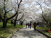 |
|
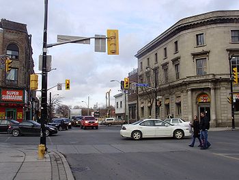
| Keele subway station Keele (TTC) Keele is a station on the Bloor–Danforth line of the subway system in Toronto, Canada. It is located at 1733 Bloor Street West at Keele Street/Parkside Drive... |
Bloor St | ||
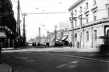
| CPR West Toronto Yard CPR West Toronto Yard West Toronto Yard is a small marshalling yard for Canadian Pacific Railway on the Galt Subdivision in Toronto, Ontario, Canada. The yard was built in 1882 to relieve stress at the Parkdale Yard and is located near Keele Street and Dundas Street West in The Junction... |
Dundas St | ||
| George Harvey Collegiate Institute George Harvey Collegiate Institute George Harvey Collegiate Institute is a high school in Toronto, Ontario, Canada located at 1700 Keele Street. It is a school focused on technology and offers a STEPS to University program as well as a program called Cybridge E3. It is also the first TDSB school to provide netbooks to... |
Rogers Road | 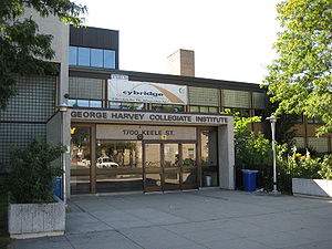 |
|
| York Memorial Collegiate Institute York Memorial Collegiate Institute York Memorial Collegiate Institute is a public school that is part of the Toronto District School Board in Toronto, Ontario, Canada, and is located at 2690 Eglinton Avenue West, at the corner of Eglinton Ave. W. and Trethewey Drive... |
Eglinton Ave |  |
|
| Humber River Regional Hospital, Keele Street Campus | Eglinton Ave | ||
| Downsview Park Downsview Park Downsview Park is a former Canadian Forces Base in the community of Downsview in Toronto, Canada. It contains about 231.5 hectares of land, of which more than 130 hectares are earmarked for traditional parkland, recreational and cultural amenities... |
Sheppard Ave | Former airfield, now a park | 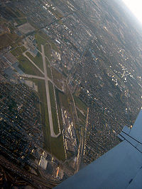 |
| York University York University York University is a public research university in Toronto, Ontario, Canada. It is Canada's third-largest university, Ontario's second-largest graduate school, and Canada's leading interdisciplinary university.... |
Steeles Ave | Toronto's second largest university | .jpg) |
| MacMillan Yard | Highway 7 | Largest rail yard in Canada | |
| Keele Valley Landfill Keele Valley Landfill The Keele Valley Landfill was the largest landfill in Canada and the third largest in North America during its operation. It was the primary landfill site for the City of Toronto and the regional municipalities of York and Durham from 1983 until 2002, and was owned and operated by the City of Toronto... |
Major Mackenzie | Once Toronto's main landfill | 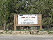 |
| King City GO Station | Station Rd | ||
| All Saints, King City All Saints, King City All Saints, King City is a parish of the Anglican Church of Canada in the Diocese of Toronto, Ecclesiastical Province of Ontario. It was established in 1857 in Springhill, now known as King City. The facility was originally built of pine cleared from the site, and was covered with brick in 1871... |
King Rd | 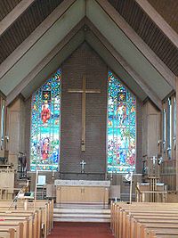 |
|
| Hogan's Inn | King Rd | ||
| St. Thomas of Villanova College St. Thomas of Villanova College St. Thomas of Villanova College is a middle school and high school in King City, Ontario, Canada. It was established at Mary Lake by lay educators Paul Paradiso and Grant Purdy in 1999 at Mary Lake Augustinian Monastery as a Catholic school together with the Order of Saint Augustine's friars of... |
Sideroad 15 | ||
| Mary Lake Augustinian Monastery Mary Lake Augustinian Monastery The Mary Lake Augustinian Monastery, also known as Mary Lake Monastery, Mary Lake Shrine, or simply Mary Lake is an Augustinian monastery in King City, Ontario, Canada. The campus is nearly , residing on Keele Street, just north of 15th Sideroad . It is part of the Province of Saint Joseph... |
Sideroad 15 |