

Kathiawar Agency
Encyclopedia
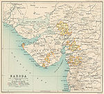
Kathiawar
Kathiawar or Kathiawad is a peninsula in western India, which is part of the Saurashtra region on the Arabian Sea coast of Gujarat state. It is bounded on the north by the great wetland of the Rann of Kutch, on the northwest by the Gulf of Kutch, on the west and south by the Arabian Sea, and on...
peninsula in the western part of the Indian subcontinent, was a political unit of some 200 small princely state
Princely state
A Princely State was a nominally sovereign entitity of British rule in India that was not directly governed by the British, but rather by an Indian ruler under a form of indirect rule such as suzerainty or paramountcy.-British relationship with the Princely States:India under the British Raj ...
s under the suzerainty
Suzerainty
Suzerainty occurs where a region or people is a tributary to a more powerful entity which controls its foreign affairs while allowing the tributary vassal state some limited domestic autonomy. The dominant entity in the suzerainty relationship, or the more powerful entity itself, is called a...
of the Bombay Presidency
Bombay Presidency
The Bombay Presidency was a province of British India. It was established in the 17th century as a trading post for the English East India Company, but later grew to encompass much of western and central India, as well as parts of post-partition Pakistan and the Arabian Peninsula.At its greatest...
of British India. Soon after India
India
India , officially the Republic of India , is a country in South Asia. It is the seventh-largest country by geographical area, the second-most populous country with over 1.2 billion people, and the most populous democracy in the world...
's independence in 1947, all but one of them acceded
Instrument of Accession
The Instrument of Accession was a legal document created in 1947 to enable each of the rulers of the princely states under British suzerainty to join one of the new dominions of India or Pakistan created by the Partition of British India.-Background:...
to the new Union of India and were merged into Bombay state
Bombay State
The Bombay State was a state of India, dissolved with the formation of Maharashtra and Gujarat states on May 1, 1960.-History:During British rule, portions of the western coast of India under direct British rule were part of the Bombay Presidency...
. The region became part of the new Gujarat state in 1960, when Bombay state was split into Gujarat and Maharashtra
Maharashtra
Maharashtra is a state located in India. It is the second most populous after Uttar Pradesh and third largest state by area in India...
states.
There were altogether 193 states of varying size and importance, of which fourteen exercised independent jurisdiction, while the rest were to varying degrees under British administration. The eight states of the first class were Bhavnagar
Bhavnagar
-Topography:Bhavnagar is a coastal city in the eastern coast of Saurashtra, also known as Kathiawar, located at . It has an average elevation of 24 metres . It occupies area of 53.30 km². General slope dips in the northeasterly direction at the apex of Gulf of Khambhat...
, Dhrangadhra
Dhrangadhra
Dhrangadhra is a city and a municipality in Surendranagar district in the state of Gujarat, India. During the period of the British Raj, the city was the capital of Dhrangadhra state, one of the eight first-class princely states of the Kathiawar Agency in the Bombay Presidency.-History:Dhrangadhra...
, Gondal, Jafarabad
Jafarabad
Jafarabad may refer to:Armenia* Getashen, Armavir, Armenia, formerly called JafarabadAzerbaijan* Aşağı Fərəcan, Azerbaijan, formerly called Jafarabad* Cəfərabad, Jabrayil, Azerbaijan* Cəfərabad, Shaki, AzerbaijanIndia...
, Junagadh
Junagadh
Junagadh is the headquarters of Junagadh district in the Indian state of Gujarat. The city is the 7th largest in Gujarat. The city is located at the foot of the Girnar hills, 355 km south west of state capital Gandhinagar and Ahmedabad. The city is in western India. Literally translated,...
, Morvi
Morvi
Morvi or Morbi is a city and a municipality in Rajkot district in the Indian state of Gujarat. It was a Princely State ruled by Jadeja clan of Rajputs until Indian independence in 1947. It is situated on the Kathiawar peninsula. , the city's population was determined to be 73,327. Its chief...
, Nawanagar
Nawanagar
Navanagar was an Indian princely state, in Kathiawar region, situated on the south of the Gulf of Kutch. It was ruled by the Jadeja dynasty from its formation in c 1540 until 1948 when it succeed to newly formed, India. The district is now known as Jamnagar. It had an area of and a population...
, and Porbandar
Porbandar
Porbandar is a coastal city in the Indian state of Gujarat, perhaps best known for being the birthplace of Mahatma Gandhi and Sudama...
. The agency covered an area of 20882 square miles (54,084.1 km²), and in 1901 the population was 2,329,196. The headquarters of the political agent (who oversaw the affairs of the princely states on behalf of the Governor-General
Governor-General of India
The Governor-General of India was the head of the British administration in India, and later, after Indian independence, the representative of the monarch and de facto head of state. The office was created in 1773, with the title of Governor-General of the Presidency of Fort William...
) was at Rajkot, in the centre of the peninsula; this was also the site of the Rajkumar College, Rajkot
Rajkumar College, Rajkot
The Rajkumar College in Rajkot is one of the oldest K-12 institutions in India. RKC has a 26 acre campus located in the heart of Rajkot city.-History:...
, where many of the sons of the rulers were educated. There was a similar school for girasias, or chiefs of lower rank, at Gondal.
The estimated gross revenue of the several states was 1,278,000 rupees
Indian rupee
The Indian rupee is the official currency of the Republic of India. The issuance of the currency is controlled by the Reserve Bank of India....
in 1911; total tribute (payable to the British, the Gaekwar of Baroda and the nawab of Junagadh
Junagadh
Junagadh is the headquarters of Junagadh district in the Indian state of Gujarat. The city is the 7th largest in Gujarat. The city is located at the foot of the Girnar hills, 355 km south west of state capital Gandhinagar and Ahmedabad. The city is in western India. Literally translated,...
), was 70,000 rupees. An excellent system of metre-gauge railways was built at the cost of the leading states. Maritime trade was also very active, the chief ports being Porbandar, Mangrol and Veraval
Veraval
Veraval is a city and a municipality in Junagadh district in the Indian state of Gujarat. It is located 6 km from Somnath.- History :...
. In 1903–1904 the total sea-borne exports were valued at 1,300,000 rupees, and the imports at 1,120,000. The progressive prosperity of Kathiawar received a shock from the famine of 1899-1900, which was felt everywhere with extreme severity; between 1891 and 1901 the population of the states covered by the Agency decreased by 15 per cent, largely due to the results of the famine.