Katama Airpark
Encyclopedia

Katama
Katama is a residential area in the town of Edgartown, Massachusetts, on the south shore of the island of Martha's Vineyard. It is bordered on the west by Edgartown Great Pond, on the east by Katama Bay and on the south by the Atlantic Ocean.The word "Katama" comes from a Wampanoag word meaning...
section of Edgartown
Edgartown, Massachusetts
Edgartown is a town located on Martha's Vineyard in Dukes County, Massachusetts, United States. The population was 3,779 at the 2000 census. It is the county seat of Dukes County. Edgartown has the largest population and area in the entire Dukes County and Martha's Vineyard.- History :In 1642....
, Massachusetts
Massachusetts
The Commonwealth of Massachusetts is a state in the New England region of the northeastern United States of America. It is bordered by Rhode Island and Connecticut to the south, New York to the west, and Vermont and New Hampshire to the north; at its east lies the Atlantic Ocean. As of the 2010...
, (508-627-9018) is a public airport owned by the Town of Edgartown. It has three runways, averages 22 flights per day, and has approximately four aircraft based on its field.
During World War II
World War II
World War II, or the Second World War , was a global conflict lasting from 1939 to 1945, involving most of the world's nations—including all of the great powers—eventually forming two opposing military alliances: the Allies and the Axis...
, Martha's Vineyard functioned both as an outer defense and a training facility for gunnery and pilots. In addition to the main Martha's Vineyard Airport
Martha's Vineyard Airport
Martha's Vineyard Airport is a public airport located in the middle of the island of Martha's Vineyard, three miles south of the central business district of Vineyard Haven, in Dukes County, Massachusetts, United States. This airport is owned by Dukes County and lies on the border between the...
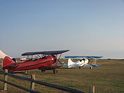
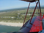
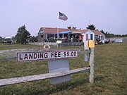
(MVY), there was a small airport at Katama near a gunnery practice area at the beach. Following World War II this airport was purchased by Steven Gentle who ran the Katama Airpark until the 1980s when it was purchased with state conservation funds (as this airfield has five endangered plant or animal species) and is currently managed by the municipal government of Edgartown. It is the quintessential grass airfield - no fancy navigation equipment. It is unique because it is possible to fly a small plane to the airport, taxi from the runway to a parking area 100 feet from the ocean, enjoy the beach during the day, and fly home in the late afternoon. During the season (roughly May 31 to Labor Day), there are biplane and glider rides available.
The Woods Hole Oceanographic Institute has a small data monitoring building adjacent to the hangar. It monitors wave action, beach erosion, and offshore wave action. It is not open to the public.