
Katama
Encyclopedia
Katama is a residential area in the town of Edgartown, Massachusetts
, on the south shore of the island of Martha's Vineyard
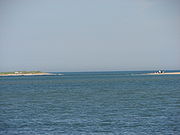
. It is bordered on the west by Edgartown Great Pond, on the east by Katama Bay (separating Katama from the island of Chappaquiddick) and on the south by the Atlantic Ocean.
The word "Katama" comes from a Wampanoag word meaning "crab-fishing place."
The terrain is a flat outwash plain, characterized by sandy soil and few trees. It is sometimes referred to as the "Great Plains."
. The train Active ran between the Oak Bluffs Wharf and Mattakeeset Lodge in Katama. The Mattakeeset Lodge (note the spelling variations of Mattakesett) was located on the shore of Katama Bay and is pictured below in a photo from the New York Library collection. A portion of the lodge including one tower was incorporated into a wing of the Harbor View Hotel in Edgartown.
Components of the Third Army, later led to fame by General George Patton in the sweep across France and the Battle of the Bulge, practiced amphibious landings at Katama during the summer of 1943 prior to shipping to England in December, 1943 as a part of the force being prepared for the D-day landings.
Edgartown, Massachusetts
Edgartown is a town located on Martha's Vineyard in Dukes County, Massachusetts, United States. The population was 3,779 at the 2000 census. It is the county seat of Dukes County. Edgartown has the largest population and area in the entire Dukes County and Martha's Vineyard.- History :In 1642....
, on the south shore of the island of Martha's Vineyard
Martha's Vineyard
Martha's Vineyard is an island located south of Cape Cod in Massachusetts, known for being an affluent summer colony....
. It is bordered on the west by Edgartown Great Pond, on the east by Katama Bay (separating Katama from the island of Chappaquiddick) and on the south by the Atlantic Ocean.
The word "Katama" comes from a Wampanoag word meaning "crab-fishing place."
The terrain is a flat outwash plain, characterized by sandy soil and few trees. It is sometimes referred to as the "Great Plains."
History
Katama has been a popular summer resort since the late 19th century. From 1874-1896, Katama was the terminus of the Martha's Vineyard RailroadMartha's Vineyard Railroad
The Martha's Vineyard Railroad was a gauge narrow gauge railroad on the island of Martha's Vineyard. It was built in 1874 to connect the Oak Bluffs wharf with the section of Edgartown known as Katama. The line closed in 1896.- Development :...
. The train Active ran between the Oak Bluffs Wharf and Mattakeeset Lodge in Katama. The Mattakeeset Lodge (note the spelling variations of Mattakesett) was located on the shore of Katama Bay and is pictured below in a photo from the New York Library collection. A portion of the lodge including one tower was incorporated into a wing of the Harbor View Hotel in Edgartown.
- Katama During World War II The Katama plains were a part of the outer defense during World War II. Military barracks were built near the beach end of Katama Road [later the Katama Shores Inn (the hotel where Mary Jo Kopechne spent her last night before her drowning on Chappaquidick) and more recently rebuilt as the Winnetu Ocean Resort. Running west from Mattakesett Way is a sunken concrete strip that runs west for approximately 3/4 of a mile. This is visible on the photo of the Katama Airfield as a line of trees running west from Mattakesett Way on a line demarcated by the Winnetu Resort. Artillery shells or rockets were shot out over the ocean from this point. In addition the beach was used as a practice target area for the squadrons assigned to the Martha's Vineyard Airport. Most of these bombs were inert, but some were live. Following the war this bombing activity was quickly forgotten and then rediscovered in the late 1980s when live bombs were uncovered by wave action on the receding beach. The beach was closed for more than a year while military demolition contractors identified and removed/detonated unexploded shells. Even today property owners find brass machine gun casings and barbed wire on their property from the World War II era.
Components of the Third Army, later led to fame by General George Patton in the sweep across France and the Battle of the Bulge, practiced amphibious landings at Katama during the summer of 1943 prior to shipping to England in December, 1943 as a part of the force being prepared for the D-day landings.
Attractions
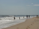
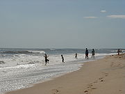
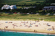
- South Beach runs the entire length of the southern end of Martha's Vineyard, however the name "South Beach" commonly refers to a stretch of public beach that is demarcated by Herring Creek Road on the west and Chappaquiddick Island on the east.
- Katama General Store on Katama Road on the way to and from South Beach has morphed from a small, traditional general store into a modern store focusing on food, gifts, and housewares. Immediately adjacent to the Katama General Store is the American Legion where bingo can be played every Thursday evening at 7:30 PM.
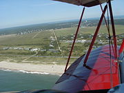
- Mattakesett refers to the southernmost portion of Katama immediately adjacent to the beach. Although the name dates back in written records to 1646, in recent times it has been most commonly associated with a resort named "Mattakesett", first developed in the mid-1970s, but named after the original 19th-century Mattakeset Lodge, which was the terminus of the Martha's Vineyard Railroad. A second resort hotel named "Winnetu" was opened in the same area in 2001. The term is also used in the street "Mattakesett Way" (runs along the east side of Katama Airpark and The Right Fork Diner to Navy Way (see aerial photo in Katama AirparkKatama AirparkKatama Airpark, in the Katama section of Edgartown, Massachusetts, is a public airport owned by the Town of Edgartown. It has three runways, averages 22 flights per day, and has approximately four aircraft based on its field....
) and "Mattakesett Herring Creek" (a small tidal creek running parallel to South Beach that functioned as a herring run earlier in the 20th century).
- Katama AirparkKatama AirparkKatama Airpark, in the Katama section of Edgartown, Massachusetts, is a public airport owned by the Town of Edgartown. It has three runways, averages 22 flights per day, and has approximately four aircraft based on its field....
is a public airport owned by the Town of Edgartown, Massachusetts. It has three runways, averages 22 flights per day, and has approximately four aircraft based on its field. During World War II, Martha's Vineyard functioned as an outer defense and a training facility for gunnery and pilots. In addition to the main Martha's Vineyard Airport (MVY), there was a small airport at Katama near a gunnery practice area at the beach. Following World War II this airport was purchased by Steven Gentle who ran the Katama Airpark until the 1980s when it was purchased with state conservation funds. It is currently managed by the municipal government of Edgartown. It is the quintessential grass airfield — no navigation equipment is based on the field. It is possible to land and park a plane no more than 100 feet from South Beach. During the summer season (roughly May 31 to Labor Day), there are biplane and glider rides available.
- The "Right Fork Diner" is the most recent name for the diner at the Edgartown Air Field. The restaurant is located immediately adjacent to the airfield and the parade of planes taxiing by the restaurant has provided endless entertainment for generations of children. The addition of a biplane ride from Classic Aviators and the soaring glider rides concession in the 1980s (or so) added another level of entertainment.
- The Farm Institute is a nonprofit farm dedicated to educating children and adults on farming and the agricultural origins of food they eat.http://www.farminstitute.org During year round education programs and community events, kids of all ages engage in a broad spectrum of farm-related chores - feeding animals, cleaning their pens, working in the summer farm stand and enjoying the daily rhythm of life on a farm. The Farm Institute operates at the Katama Farm (pictured in aerial view of Katama Airpark), which was purchased by the town of Edgartown with state conservation funds. The FARM Institute raises and sells grass fed beef and lamb and pastured pork and poultry at the farm and to the community in support of its mission. In addition to education programs, The FARM Institute offers a broad range of community activities and events.
- The Boat Landing on Edgartown Bay Road in the southeast corner of Katama is maintained by the town of Edgartown. Boats are launched into Katama Bay and exit to the ocean through Edgartown Harbor to the north. The boat landing accommodates 20-foot boats from an inclined ramp.
- Katama Bay, a popular kayaking, windsurfing and kiteboarding spot, is defined by the eastern end of Martha's Vineyard Island, the western end of Chappaquiddick Island, and on the south by a barrier beach. The tide replenishes Katama Bay through Edgartown Harbor to the north. In April 2007, a storm led to a breach in the barrier beach connecting Katama to Chappaquiddick. This breach subsequently enlarged, leading to an increased ocean tide in Katama Bay and a brisk tidal current running north from the breach into Edgartown Harbor. As of January 2011 the breach is migrating steadily eastward, closer to the Chappaquidick end of Katama Bay.
- Katama Farm. This is a great show farm that still works. Young children may enter the horse barn to pet animals that could include chicks or angora goats. In the summer the farm creates a corn maze that is available to the public for exploration.
See also
- M/V Katama, Steamship AuthorityThe Woods Hole, Martha's Vineyard and Nantucket Steamship AuthorityThe Woods Hole, Martha's Vineyard and Nantucket Steamship Authority, referred to coloquially as The Steamship Authority or simply the SSA, is the statutory regulatory body for all ferry operations to and from the Islands from the Massachusetts mainland, as well as being an operator of ferry service...
freight ship named after the region.