
Kapa'a, Hawai'i
Encyclopedia
Kapaa is a census-designated place
(CDP) in Kauai County
, Hawaii
, United States
. The population was 9,472 at the 2000 census.
The town has a large concentration of hotels, shopping centers, and tourist-oriented shops and restaurants.
 Kapaa is located at (22.088281, -159.337706).
According to the United States Census Bureau
, the CDP has a total area of 10 square miles (25.9 km²). 9.8 square miles (25.4 km²) of it is land and 0.2 square mile (0.517997622 km²) of it (2.40%) is water.
of 2000, there were 9,471 people, 3,129 households, and 2,281 families residing in the CDP. The population density
was 971.2 inhabitants per square mile (375.1/km²). There were 3,632 housing units at an average density of 372.4 per square mile (143.8/km²). The racial makeup of the CDP was 27.8% White, 0.3% African American, 0.5% Native American, 31.7% Asian, 10.0% Pacific Islander, 1.0% from other races
, and 28.7% from two or more races. Hispanic or Latino of any race were 9.5% of the population.
There were 3,129 households out of which 40.6% had children under the age of 18 living with them, 51.1% were married couples
living together, 15.0% had a female householder with no husband present, and 27.1% were non-families. 20.4% of all households were made up of individuals and 6.2% had someone living alone who was 65 years of age or older. The average household size was 2.99 and the average family size was 3.44.
In the CDP the population was spread out with 29.8% under the age of 18, 7.8% from 18 to 24, 29.3% from 25 to 44, 22.8% from 45 to 64, and 10.4% who were 65 years of age or older. The median age was 35 years. For every 100 females there were 98.2 males. For every 100 females age 18 and over, there were 94.9 males.
The median income for a household in the CDP was $39,448, and the median income for a family was $45,878. Males had a median income of $30,129 versus $25,680 for females. The per capita income
for the CDP was $16,878. About 14.1% of families and 15.7% of the population were below the poverty line, including 18.6% of those under age 18 and 12.6% of those age 65 or over.
Census-designated place
A census-designated place is a concentration of population identified by the United States Census Bureau for statistical purposes. CDPs are delineated for each decennial census as the statistical counterparts of incorporated places such as cities, towns and villages...
(CDP) in Kauai County
Kauai County, Hawaii
Kauai County is a county located in the U.S. state of Hawaii. It consists of the islands of Kauai, Niihau, Lehua, and Kaula, in the state of Hawaii. As of 2000 Census the population was 58,463...
, Hawaii
Hawaii
Hawaii is the newest of the 50 U.S. states , and is the only U.S. state made up entirely of islands. It is the northernmost island group in Polynesia, occupying most of an archipelago in the central Pacific Ocean, southwest of the continental United States, southeast of Japan, and northeast of...
, United States
United States
The United States of America is a federal constitutional republic comprising fifty states and a federal district...
. The population was 9,472 at the 2000 census.
The town has a large concentration of hotels, shopping centers, and tourist-oriented shops and restaurants.
History
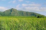
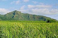
Kapaa means solid in Hawaiian. The town is located in the ancient district of Puna, in the Kapaa ahupuaa or county. Ahupuaa were pie shaped wedges of land that stretched from mountain to sea allowing its inhabitants the full range of landscapes and climates. The famous "Sleeping Giant" or Nounou Mountain overlooks the town. Agriculture was a big industry throughout most of the 19th and 20th centuries. Sugar cane was grown along with the largest pineapple fields on Kauai. A pineapple cannery was located where the Pono Kai condominiums now stand.Geography
According to the United States Census Bureau
United States Census Bureau
The United States Census Bureau is the government agency that is responsible for the United States Census. It also gathers other national demographic and economic data...
, the CDP has a total area of 10 square miles (25.9 km²). 9.8 square miles (25.4 km²) of it is land and 0.2 square mile (0.517997622 km²) of it (2.40%) is water.
Demographics
As of the censusCensus
A census is the procedure of systematically acquiring and recording information about the members of a given population. It is a regularly occurring and official count of a particular population. The term is used mostly in connection with national population and housing censuses; other common...
of 2000, there were 9,471 people, 3,129 households, and 2,281 families residing in the CDP. The population density
Population density
Population density is a measurement of population per unit area or unit volume. It is frequently applied to living organisms, and particularly to humans...
was 971.2 inhabitants per square mile (375.1/km²). There were 3,632 housing units at an average density of 372.4 per square mile (143.8/km²). The racial makeup of the CDP was 27.8% White, 0.3% African American, 0.5% Native American, 31.7% Asian, 10.0% Pacific Islander, 1.0% from other races
Race (United States Census)
Race and ethnicity in the United States Census, as defined by the Federal Office of Management and Budget and the United States Census Bureau, are self-identification data items in which residents choose the race or races with which they most closely identify, and indicate whether or not they are...
, and 28.7% from two or more races. Hispanic or Latino of any race were 9.5% of the population.
There were 3,129 households out of which 40.6% had children under the age of 18 living with them, 51.1% were married couples
Marriage
Marriage is a social union or legal contract between people that creates kinship. It is an institution in which interpersonal relationships, usually intimate and sexual, are acknowledged in a variety of ways, depending on the culture or subculture in which it is found...
living together, 15.0% had a female householder with no husband present, and 27.1% were non-families. 20.4% of all households were made up of individuals and 6.2% had someone living alone who was 65 years of age or older. The average household size was 2.99 and the average family size was 3.44.
In the CDP the population was spread out with 29.8% under the age of 18, 7.8% from 18 to 24, 29.3% from 25 to 44, 22.8% from 45 to 64, and 10.4% who were 65 years of age or older. The median age was 35 years. For every 100 females there were 98.2 males. For every 100 females age 18 and over, there were 94.9 males.
The median income for a household in the CDP was $39,448, and the median income for a family was $45,878. Males had a median income of $30,129 versus $25,680 for females. The per capita income
Per capita income
Per capita income or income per person is a measure of mean income within an economic aggregate, such as a country or city. It is calculated by taking a measure of all sources of income in the aggregate and dividing it by the total population...
for the CDP was $16,878. About 14.1% of families and 15.7% of the population were below the poverty line, including 18.6% of those under age 18 and 12.6% of those age 65 or over.