

Kanaga Island
Encyclopedia
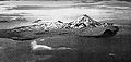
Kanaga Island is a part of the Andreanof Islands
group of the Aleutian Islands in Alaska
. The island measures roughly 30 miles (48 kilometers) long and between 4 and 8 miles (6 to 13 km) wide with an area of 142 sq mi (369 km²), making it the 42nd largest island in the United States. The island's most notable feature is Mount Kanaga
, a 4288 feet (1,307 m) high (1,307 m) volcano
which last erupted in 1995.
Andreanof Islands
The Andreanof Islands are a group of islands in the Aleutian Islands in southwest Alaska. They are located between Amchitka Pass and the Rat Islands group to the west, and Amukta Pass and the Islands of Four Mountains group to the east, at about 52° North and 172°57' to 179°09' West. The islands...
group of the Aleutian Islands in Alaska
Alaska
Alaska is the largest state in the United States by area. It is situated in the northwest extremity of the North American continent, with Canada to the east, the Arctic Ocean to the north, and the Pacific Ocean to the west and south, with Russia further west across the Bering Strait...
. The island measures roughly 30 miles (48 kilometers) long and between 4 and 8 miles (6 to 13 km) wide with an area of 142 sq mi (369 km²), making it the 42nd largest island in the United States. The island's most notable feature is Mount Kanaga
Mount Kanaga
Mount Kanaga is a stratovolcano at the northern tip of Kanaga Island in the Aleutian Islands, Alaska. It is situated within a caldera, which forms the arcuate Kanaton Ridge south and east of Kanaga. A crater lake occupies part of the SE caldera floor. The summit of Kanaga has a crater with...
, a 4288 feet (1,307 m) high (1,307 m) volcano
Volcano
2. Bedrock3. Conduit 4. Base5. Sill6. Dike7. Layers of ash emitted by the volcano8. Flank| 9. Layers of lava emitted by the volcano10. Throat11. Parasitic cone12. Lava flow13. Vent14. Crater15...
which last erupted in 1995.