
Kaesong
Encyclopedia
Kaesŏng is a city in North Hwanghae Province, southern North Korea
(DPRK), a former Directly Governed City, and the capital of Korea
during the Koryo Dynasty
. The city is near Kaesŏng Industrial Region
and it contains the remains of the Manwoldae palace
. It was formally named Songdo while it was the ancient capital of Koryo. It prospered as a trade center that produced Korean ginseng
, which is famous internationally. It is now the DPRK's light industry centre. It has a population of 308,440 as of 2008.
, and was referred to as Busogap during the rule of Goguryeo
. Before the strength of Baekje
was retreated to the southwest of Jungnyeong
, Joryeong, and Asan Bay in 475, the area had been a part of Baekje
for about 100 years. However, it became a territory of Silla since 555, the 16th year of King Jinheung and its name was changed to "Songak-gun" during the period. According to Samguk Sagi
, when a castle was built in the site in 694, the third year of King Hyoso's reign, Kaesong was referred to as "Songak (송악; 松嶽)". Therefore, it is assumed that the name, Songak had been used at least before the time.
Silla began to decline in late 9th century, and a period of rival warlords ensued. In 898, Kaesong fell under the hand of Gung Ye
, the founder of his short-lived state, Later Goguryeo, and than subsequently became a part of Goryeo
in 919 by its founder, Wang Geon. Wang Geon established the capital in the south of Songak, and incorporated Kaesong County into Songak under the name of "Gaeju". In 919, Kaesong became the national capital. In 960, the 11th year of King Gwangjong
's reign, the city was renamed as Gaegyeong, and in 995, the 14th year of King Seongjong
's reign, it was elevated as "Gaesong-bu". The Gaeseong-bu is a combined term of Songak-gun, and Gaesong-gun, which is different from the region of the pre-1945 Gaesong-ri, Seo-myeon, Kaepung-gun. In 1010, the first year of King Hyeonjong
's reign, the palace and houses were almost burnt down during the Second Goryeo–Khitan War
, so in 1018, Gaesong-bu was relegated for the "bu" system, and became to govern the three hyeon unites of Jeongju, Deoksu, and Gangeum. In the late 12th century, there was a period of instability in both the government and the countryside. A slave named Manjǒk
(or spelled as Manjeok) (만적; 萬積) led a group of slaves who gathered outside Kaesong in 1198. The revolt plot was suppressed by Choe Chung-heon
. When Yi Songgye overthrew the Koryo Dynasty in 1392 and established the Joseon Dynasty
, he moved the Korean capital from Kaesŏng to Hanyang (modern-day Seoul
) in 1394.
Kaesŏng remained a part of Gyonggi Province until the Korean War
. In 1951, the city (which had been part of South Korea
) came under North Korea
n control, and the part of Kyonggi Province that came to be occupied was organized into "Kaesŏng Region" (Kaesŏng Chigu; 개성 지구; 開城 地區). In 1955, Kaesŏng became a "Directly Governed City" (Kaesŏng Chikhalsi; 개성 직할시; 開城 直轄市). In 2002, Kaesŏng Industrial Region
was formed from part of Kaesŏng. In 2003, the remaining part of Kaesŏng (excluding the Industrial Region) became part of North Hwanghae Province. The city is close to the Demilitarized Zone
that divides North and South Korea. When Korea was partitioned at the 38th parallel
after World War Two, Kaesong was on the southern side of the line (within the Republic of Korea). Thus Kaesong was the only city to change control from South to North Korea after the Korean War.
, Changpung
, Panmun, and Kumchon
counties. Kanghwa Island of Incheon
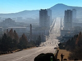
Municipality lies just south, beyond a narrow channel. It covers an area of 1,309 km², the urban district is surrounded by Mts. Songak
(Songak-san; 송악산; 松嶽山) (489 m) and Pongmyong. The city center surrounds the much smaller Mt. Janam (103 m), on which is located the city's iconic Kim Il Sung statue.
In the northern part of Kaesong, the end of the Ahobiryŏng
range creates the northernmost border of Kaesong City. This range consists of Mts. Chŏnma (757 m), Sŏnggŏ, Myoji (764 m), Suryong (716 m), Chesŏk (749 m), Hwajang (558 m), and Ogwan. With the exception of the mountainous northeastern region, however, most areas of Kaesong consist of low hills with the height less than 100 meters.
The Imjin River
flows along the northeastern border line of the city and the Ryesong River
(禮成江) (Ryeseong-gang; 례성강) (spelled in South Korea as Yeseong-gang; 예성강) runs along the western border to the mouth of the Han River
. In addition to the two rivers, small and large rivers and streams such as Samich'ŏn, Wŏlamch'ŏn,, Chukbaech'ŏn, Kŭmsŏngch'ŏn and Sach'ŏn rivers drain into the Han. The river basin located in the southwest of Kaesong has spacious alluvial plains such as P'ungdŏkbŏl, Singwangbŏl, and Samsŏngbŏl.
The geology consists of the Proterozoic
, Cenozoic
, and Paleozoic
strata
and Mesozoic
intrusive granite
. The underground resources include gold
, zinc
, copper
, fluorspar, limestone
, granite, and kaolin. The soil comprises generally brown forest soil while the areas drained by Yesŏng, Imjin, and Han rivers consist of mostly alluvial and saline soil. The climate is generally warm and moderate, so the average annual temperature is around 10 ℃. The coldest month is January, with an average temperature of ―5.9℃ while the hottest month is August, with the average temperature of 24.7℃. The average annual rainfall is 1,300~1,400 millimeters. The duration of frost-free period is 180 days which is the longest in North Korea. The forest area takes up about 55 percentage of Kaesong, among which forests of pine trees form the 80 percentage. Various types of species inhabit in Kaesong, with 40 different species of mammal, and 250 birds.
, Kaep'ung-gun
and P'anmun-gun. In 2003, P'anmun-gun and part of Kaesŏng-si were separated from Kaesŏng Directly Governed City and merged to form Kaesŏng Industrial Region
. The remaining part of Kaesŏng joined North Hwanghae in 2002. Kaesong is currently divided into 24 administrative districts known as Dong, as wells as three villages ("ri").
(Light Industry), Communist University and Art College are located in Kaesŏng. The Koryo Museum, housed in the city's old Confucian academy, contains many priceless Koryo arts and cultural relics (although many are copies, with the originals held in the vaults of the Korean Central History Museum in Pyongyang
. As the former capital of the Koryo dynasty, the tombs of almost all of the Koryo kings are located in the area, though most are not accessible; the heavily reconstructed Hyollung Royal Tomb
, belonging to the dynasty's founder, Taejo
, is located to the west of the city in Kaepung-gun. Other notable tombs include those of kings Hyejong
(the Sollung Royal Tomb), Kyongjong
(Yongrung), Songjong
(Kangrung), Hyonjong
(Sollung), Munjong
(Kyongrung), and Kongmin
(Hyonjongrung
). Kaesong also contains north Korea's only two royal tombs dating to the Joseon
dynasty; the Hurung Royal Tomb
, belonging to the dynasty's second king, Jongjong
, and the Cherung Royal Tomb
, containing the remains of Queen Sinui, wife of the dynasty's founder, Yi Songgye. The two final tombs, despite belonging to members of the Joseon royal family, were excluded from the World Heritage listed
"Royal Tombs of the Joseon Dynasty
because of their location in North Korea.
with almost 500 years of rule, its culinary culture was highly developed. The luxurious style of Kaesong cuisine is frequently compared with those of Seoul
cuisine and Jeolla
cuisine. Kaesong cuisine was traditionally treated as part of Gyeonggi cuisine, since Kaesong belonged to Gyeonggi province until 1950. However, it has been incorporated into the administration of North Korea after the Korean War
while Gyeonggi province is administered by South Korea. Bossam kimchi (wrapped kimchi), pyeonsu (summer mandu in square shape), sinseollo
(royal casserole), seolleongtang
(beef tripe soup), chueotang (mudfish soup), joraengi tteokguk (rice cake soup), umegi (tteok covered with syrup), and gyeongdan (ball-shaped tteok) are representative Kaesong dishes. Umegi, also called Kaesong juak is a holiday food of Kaesong, and known for the delicate style with the sweet and nutty taste. The dish is made by kneading a mixture of rice flour and glutinous rice flour with warm water, by shaping the dough into balls with either one pine nut or jujube
, by frying and coating them with syrup.
, climate, soil conditions, Kaesong has advantageous natural conditions for agricultural productions. The water supply
system is established with 18 reservoirs including Songdo Reservoir built for agricultural advances and about 150 pumping station
s as well as hundreds of dammed pools. The cultivated land accounts for the 27 percentage of Kaesong, and rice, maize
, soybean
s, wheat, and barley are the main crops. Among them, rice production accounts for the 60 percentage of the whole grain production, and Kaepung
and Panmun are the two primary regions, producing more than 70 percentage of the rice production. In addition, vegetable and fruit cultivation including peach, apple and persimmon
, livestock farming, and sericulture
are active. Peach is a local specialty of Kaesong, and especially white peach is famous, so the production of the latter accounts for more than 25 percentage of the gross fruit production. The counties of Kaepung-gun and Panmun-gun are also known for the good quality of Korean ginseng
called Goryeo Insam, and the active ginseng cultivation. The processing and exporting the product take place around the counties.
Kaesŏng is DPRK’s light industry
centre. The urban district is equipped with a jewel
processing factory, ginseng processing factory and an embroidery
factory. Since the Goryeo
period, Kaesong had been a center of handcrafts such as Goryeo porcelain, and commerce while the textile industry
has been the primary business along with the production of grocery goods, daily general goods, and ginseng products after the division into the two states. The food processing industry ranks the right next to the textile business, mainly producing jang
(soybean-based condiments), oil, canned foods, alcoholic beverages, soft drink
s and others. In addition, resin
, timber
, handicrafts, pottery, shoes, school supplies
, musical instruments, and glass are produced. Kaesong has factories for producing agricultural machines and tractor repair. As of 2002, the city had the headquarters of the Central Bank of North Korea and branches in Kapung and Panmun counties as financial institutions.
gate, the Songgyungwan Confucian Academy, now the Koryo Museum, and the Sonjuk Bride and Pyochung Pavilion
. Less-known sites include Kwandok Pavilion, the ruined Koryo-era Manwoldae Palace, Anhwa Temple, Sungyang Hall
, Mokchong Hall, and the Kaesong Chomsongdae (개성 첨성대; 開城 瞻星臺) observatory. Located to the west of the city are the tombs of Kings Kongmin
and Wanggon
; twenty-four km north of Kaesong is Taehungsan Fortress
, a Koguryo satellite fortress built to protect Pyongyang
. This castle contains the Kwanum
and Taehung Temples. The famous Pakyon Falls are located in the area, as well as a large, recently discovered Koryo-dynasty Buddha carved into the stone on Mt. Chonma. Most tourists to Kaesong are put in the traditional Kaesong Folk Hotel
, housed in 19 traditional hanok
courtyard houses.
, one kilometer north of Seonjukgyo bridge is a representative traditional educational institution in Kaesong. It was founded in the neighborhood of Gukja-dong with the name of "Gukjagam
(국자감; 國子監)" in 992 during the reign of King Seongjong
of Goryeo
, which ignited Confucian studies in Korea
. Its name was changed to Gukhak
(국학; 國學) in the reign of King Chungnyeol
, and was referred to as Seonggyungwan. In 1367, the 16th year of King Gongmin
's reign, the structure was revamped and Yi Saek
, and Jeong Mong-ju
, Confucian scholars of the time taught there as professors. In 1592, the 25th year of King Seonjo's reign during the Joseon Dynasty
, Kim Yuk reconstructed the institution which was burned down by the Japanese during the Imjin War.
The first modern school that appeared in Kaesong was Hanyeong Seowon (한영서원; 韓英書院), or Anglo-Korean School established by Yun Chi-ho in 1906, with the help of American missionary Mr. Wasson, and Mr. Candler. It obtained authorization as Songdo High School from Governor-General of Korea
in 1917, and expanded to the Songdo School Foundation in 1950 with the accreditation for the establishment of Songdo Middle School and Songdo College of Pharmacy, the latter of which produced 40 graduates. However, when the Korean War occurred, the foundation was moved to Incheon, and reconstructed Songdo Middle and High Schools in 1953 which still exist to the present.
As of 2002, Kaesong had 80 each public elementary schools which scattered in each unit of ri (village), 60 middle-high schools, 3 colleges and 3 universities such as Songdo University of Politics, Kaesong University of Education, and Kaesong Communist University.
and other cities by rail, highways and a dual purpose military and civilian airport. The city's main railway station is Kaesong Station
, which is on the Pyongbu Line
.
) (1990)(Belém
) (1994) (Tacna
) (1996) (Kathmandu) (1992) (Mumbai
) (1999) (Cartagena
) (2002) (Bălţi
) (1997)
North Korea
The Democratic People’s Republic of Korea , , is a country in East Asia, occupying the northern half of the Korean Peninsula. Its capital and largest city is Pyongyang. The Korean Demilitarized Zone serves as the buffer zone between North Korea and South Korea...
(DPRK), a former Directly Governed City, and the capital of Korea
Korea
Korea ) is an East Asian geographic region that is currently divided into two separate sovereign states — North Korea and South Korea. Located on the Korean Peninsula, Korea is bordered by the People's Republic of China to the northwest, Russia to the northeast, and is separated from Japan to the...
during the Koryo Dynasty
Goryeo
The Goryeo Dynasty or Koryŏ was a Korean dynasty established in 918 by Emperor Taejo. Korea gets its name from this kingdom which came to be pronounced Korea. It united the Later Three Kingdoms in 936 and ruled most of the Korean peninsula until it was removed by the Joseon dynasty in 1392...
. The city is near Kaesŏng Industrial Region
Kaesong Industrial Region
Kaesŏng Industrial Region is a special administrative industrial region of North Korea. It was formed in 2002 from part of Kaesŏng Directly Governed City.-Kaesŏng Industrial Park:...
and it contains the remains of the Manwoldae palace
Manwoldae
Manwŏldae Palace was the official royal palace of the Goryeo Dynasty. Located in the ancient capital city of Kaesŏng, the palace was completely destroyed during the Red Turbans invasions of Korea during the 14th century.-History:...
. It was formally named Songdo while it was the ancient capital of Koryo. It prospered as a trade center that produced Korean ginseng
Ginseng
Ginseng is any one of eleven species of slow-growing perennial plants with fleshy roots, belonging to the genus Panax of the family Araliaceae....
, which is famous internationally. It is now the DPRK's light industry centre. It has a population of 308,440 as of 2008.
History
The earliest archaeological signs of habitation in the Kaesong area date from the Neolithic Age. Artifacts such as Jeulmun pottery, stone ware, and stone axes have been excavated from Mount Osong and Kaesong Nasong (double-walled fortress of Kaesong). As Kaesong has been occupied by various states throughout centuries, its name has changed as well. It was realm of Mahan confederacyMahan confederacy
Mahan was a loose confederacy of statelets that existed from around the 1st century BCE to 3rd century CE in the southern Korean peninsula in the Chungcheong and Jeolla provinces. Arising out of the confluence of Gojoseon migration and the Jin state federation, Mahan was one of the Samhan , along...
, and was referred to as Busogap during the rule of Goguryeo
Goguryeo
Goguryeo or Koguryŏ was an ancient Korean kingdom located in present day northern and central parts of the Korean Peninsula, southern Manchuria, and southern Russian Maritime province....
. Before the strength of Baekje
Baekje
Baekje or Paekche was a kingdom located in southwest Korea. It was one of the Three Kingdoms of Korea, together with Goguryeo and Silla....
was retreated to the southwest of Jungnyeong
Jungnyeong
Jungnyeong is a mountain pass in the Sobaek Mountains of central South Korea. It reaches a height of . It stands on the flank of Sobaeksan, which reaches more than twice that height....
, Joryeong, and Asan Bay in 475, the area had been a part of Baekje
Baekje
Baekje or Paekche was a kingdom located in southwest Korea. It was one of the Three Kingdoms of Korea, together with Goguryeo and Silla....
for about 100 years. However, it became a territory of Silla since 555, the 16th year of King Jinheung and its name was changed to "Songak-gun" during the period. According to Samguk Sagi
Samguk Sagi
Samguk Sagi is a historical record of the Three Kingdoms of Korea: Goguryeo, Baekje and Silla. The Samguk Sagi is written in Classical Chinese and its compilation was ordered by Goryeo's King Injong Samguk Sagi (History of the Three Kingdoms) is a historical record of the Three Kingdoms of...
, when a castle was built in the site in 694, the third year of King Hyoso's reign, Kaesong was referred to as "Songak (송악; 松嶽)". Therefore, it is assumed that the name, Songak had been used at least before the time.
Silla began to decline in late 9th century, and a period of rival warlords ensued. In 898, Kaesong fell under the hand of Gung Ye
Gung Ye
Gung Ye was the king of the short-lived Hugoguryeo on the Korean peninsula. Although he was a member of the Silla royal family, he became a victim of the power struggle among the royal family members during the late 9th century...
, the founder of his short-lived state, Later Goguryeo, and than subsequently became a part of Goryeo
Goryeo
The Goryeo Dynasty or Koryŏ was a Korean dynasty established in 918 by Emperor Taejo. Korea gets its name from this kingdom which came to be pronounced Korea. It united the Later Three Kingdoms in 936 and ruled most of the Korean peninsula until it was removed by the Joseon dynasty in 1392...
in 919 by its founder, Wang Geon. Wang Geon established the capital in the south of Songak, and incorporated Kaesong County into Songak under the name of "Gaeju". In 919, Kaesong became the national capital. In 960, the 11th year of King Gwangjong
Gwangjong of Goryeo
Gwangjong was the fourth emperor of Goryeo.Goryeo met the time of change by ascending of Gwangjong. At his early stage as ruler, he maintained a passive attitude to nobles. However, he became more and more drastic. Choi Seung-Ro said that his regime can be divided into three parts. First is the...
's reign, the city was renamed as Gaegyeong, and in 995, the 14th year of King Seongjong
Seonjong of Goryeo
Seonjong of Goryeo was the 13th emperor of Goryeo. He's the second son of Empress Inye and born in September, 1049. He was sealed as marquis of Gukwon in March, 1056. Harmony of Confucism and Buddhism made his political statue very stable...
's reign, it was elevated as "Gaesong-bu". The Gaeseong-bu is a combined term of Songak-gun, and Gaesong-gun, which is different from the region of the pre-1945 Gaesong-ri, Seo-myeon, Kaepung-gun. In 1010, the first year of King Hyeonjong
Hyeonjong of Goryeo
Hyeonjong of Goryeo was the 8th ruler of the Goryeo dynasty of Korea. He was a grandson of Emperor Taejo. He was appointed by the military leader Gang Jo, whom the previous Emperor Mokjong had called upon to destroy a plot by Kim Chi-yang.In 1010, The Khitan attacked again during an internal...
's reign, the palace and houses were almost burnt down during the Second Goryeo–Khitan War
Second Goryeo–Khitan War
The Second Goryeo-Khitan War was an 11th-century conflict between the kingdom of Goryeo and Khitan forces near what is now the border between China and North Korea. It was the second of the Goryeo-Khitan Wars, with the First Goryeo-Khitan War occurring in 993, the second in 1010, and the third in...
, so in 1018, Gaesong-bu was relegated for the "bu" system, and became to govern the three hyeon unites of Jeongju, Deoksu, and Gangeum. In the late 12th century, there was a period of instability in both the government and the countryside. A slave named Manjǒk
Manjeok
Manjǒk was a slave in the Goryeo era Korea. It is said that he was a slave of Choe Chung-heon, a powerful military dictator at that time. He and some other slaves plotted a rebellion in 1198 against their masters in Kaesong, the capital of Goryeo...
(or spelled as Manjeok) (만적; 萬積) led a group of slaves who gathered outside Kaesong in 1198. The revolt plot was suppressed by Choe Chung-heon
Choe Chung-heon
Choe Chung-heon was a military ruler of Korea during the Goryeo period.Choe's father was a Grand General in the Goryeo military, hence precipitating his own entry into the military...
. When Yi Songgye overthrew the Koryo Dynasty in 1392 and established the Joseon Dynasty
Joseon Dynasty
Joseon , was a Korean state founded by Taejo Yi Seong-gye that lasted for approximately five centuries. It was founded in the aftermath of the overthrow of the Goryeo at what is today the city of Kaesong. Early on, Korea was retitled and the capital was relocated to modern-day Seoul...
, he moved the Korean capital from Kaesŏng to Hanyang (modern-day Seoul
Seoul
Seoul , officially the Seoul Special City, is the capital and largest metropolis of South Korea. A megacity with a population of over 10 million, it is the largest city proper in the OECD developed world...
) in 1394.
Kaesŏng remained a part of Gyonggi Province until the Korean War
Korean War
The Korean War was a conventional war between South Korea, supported by the United Nations, and North Korea, supported by the People's Republic of China , with military material aid from the Soviet Union...
. In 1951, the city (which had been part of South Korea
South Korea
The Republic of Korea , , is a sovereign state in East Asia, located on the southern portion of the Korean Peninsula. It is neighbored by the People's Republic of China to the west, Japan to the east, North Korea to the north, and the East China Sea and Republic of China to the south...
) came under North Korea
North Korea
The Democratic People’s Republic of Korea , , is a country in East Asia, occupying the northern half of the Korean Peninsula. Its capital and largest city is Pyongyang. The Korean Demilitarized Zone serves as the buffer zone between North Korea and South Korea...
n control, and the part of Kyonggi Province that came to be occupied was organized into "Kaesŏng Region" (Kaesŏng Chigu; 개성 지구; 開城 地區). In 1955, Kaesŏng became a "Directly Governed City" (Kaesŏng Chikhalsi; 개성 직할시; 開城 直轄市). In 2002, Kaesŏng Industrial Region
Kaesong Industrial Region
Kaesŏng Industrial Region is a special administrative industrial region of North Korea. It was formed in 2002 from part of Kaesŏng Directly Governed City.-Kaesŏng Industrial Park:...
was formed from part of Kaesŏng. In 2003, the remaining part of Kaesŏng (excluding the Industrial Region) became part of North Hwanghae Province. The city is close to the Demilitarized Zone
Korean Demilitarized Zone
The Korean Demilitarized Zone is a strip of land running across the Korean Peninsula that serves as a buffer zone between North and South Korea. The DMZ cuts the Korean Peninsula roughly in half, crossing the 38th parallel on an angle, with the west end of the DMZ lying south of the parallel and...
that divides North and South Korea. When Korea was partitioned at the 38th parallel
38th parallel north
The 38th parallel north is a circle of latitude that is 38 degrees north of the Earth's equatorial plane. It crosses Europe, the Mediterranean Sea, Asia, the Pacific Ocean, North America, and the Atlantic Ocean...
after World War Two, Kaesong was on the southern side of the line (within the Republic of Korea). Thus Kaesong was the only city to change control from South to North Korea after the Korean War.
Geography
Located in the center of Korea, Kaesong is the southernmost city of North Korea. It is bordered by KaepungKaepung
Kaep'ung is a county in North Hwanghae province, North Korea. Formerly part of the Kaesong urban area, the county was merged with North Hwanghae when Kaesong was demoted in 2003...
, Changpung
Changpung
Changp'ung is a county in North Hwanghae province, North Korea. Formerly part of the Kaesong urban area, the county was merged with North Hwanghae when Kaesong was demoted in 2003...
, Panmun, and Kumchon
Kumchon
Kŭmch'ŏn is a county in North Hwanghae province, North Korea. It has a population of 68,216.-Geography:Kumchon is bordered to the west by Kaesong, to the south by Kaepung, to the northwest by Tosan, and to the north by Mt. Pakbong and Singye county. It is bordered to the east by the Ryesong River,...
counties. Kanghwa Island of Incheon
Incheon
The Incheon Metropolitan City is located in northwestern South Korea. The city was home to just 4,700 people when Jemulpo port was built in 1883. Today 2.76 million people live in the city, making it Korea’s third most populous city after Seoul and Busan Metropolitan City...
Municipality lies just south, beyond a narrow channel. It covers an area of 1,309 km², the urban district is surrounded by Mts. Songak
Mt. Songak
Mt. Songak is a simple volcano which has double craters and a parasitic volcano. Crater 1 is about 500 m in diameter, 1.7 km in circumference. Crater 2, the mouth of the volcano in Crater 1, is about 400 m in diameter, 69 m in depth and leans vertically....
(Songak-san; 송악산; 松嶽山) (489 m) and Pongmyong. The city center surrounds the much smaller Mt. Janam (103 m), on which is located the city's iconic Kim Il Sung statue.
In the northern part of Kaesong, the end of the Ahobiryŏng
Ahobiryong Mountains
The Ahobiryong Mountains are a mountain range stretching from north to south in central North Korea. The range straddles the border between North Hwanghae and Kangwon provinces...
range creates the northernmost border of Kaesong City. This range consists of Mts. Chŏnma (757 m), Sŏnggŏ, Myoji (764 m), Suryong (716 m), Chesŏk (749 m), Hwajang (558 m), and Ogwan. With the exception of the mountainous northeastern region, however, most areas of Kaesong consist of low hills with the height less than 100 meters.
The Imjin River
Imjin River
The Imjin River is a river of North and South Korea. It flows from North to South, crossing the Demilitarized Zone and joining the Han River downstream of Seoul, very near the Yellow Sea.- History :...
flows along the northeastern border line of the city and the Ryesong River
Ryesong River
The Ryesŏng River is a river of North Korea. It flows from north to south, emptying into the Yellow Sea by Ganghwa Island, just west of the mouth of the River Imjin....
(禮成江) (Ryeseong-gang; 례성강) (spelled in South Korea as Yeseong-gang; 예성강) runs along the western border to the mouth of the Han River
Han River (Korea)
The Han River is a major river in South Korea and the fourth longest river on the Korean peninsula after the Amnok, Duman, and Nakdong rivers. It is formed by the confluence of the Namhan River , which originates in Mount Daedeok, and the Bukhan River , which originates on the slopes of Mount...
. In addition to the two rivers, small and large rivers and streams such as Samich'ŏn, Wŏlamch'ŏn,, Chukbaech'ŏn, Kŭmsŏngch'ŏn and Sach'ŏn rivers drain into the Han. The river basin located in the southwest of Kaesong has spacious alluvial plains such as P'ungdŏkbŏl, Singwangbŏl, and Samsŏngbŏl.
The geology consists of the Proterozoic
Proterozoic
The Proterozoic is a geological eon representing a period before the first abundant complex life on Earth. The name Proterozoic comes from the Greek "earlier life"...
, Cenozoic
Cenozoic
The Cenozoic era is the current and most recent of the three Phanerozoic geological eras and covers the period from 65.5 mya to the present. The era began in the wake of the Cretaceous–Tertiary extinction event at the end of the Cretaceous that saw the demise of the last non-avian dinosaurs and...
, and Paleozoic
Paleozoic
The Paleozoic era is the earliest of three geologic eras of the Phanerozoic eon, spanning from roughly...
strata
Stratum
In geology and related fields, a stratum is a layer of sedimentary rock or soil with internally consistent characteristics that distinguish it from other layers...
and Mesozoic
Mesozoic
The Mesozoic era is an interval of geological time from about 250 million years ago to about 65 million years ago. It is often referred to as the age of reptiles because reptiles, namely dinosaurs, were the dominant terrestrial and marine vertebrates of the time...
intrusive granite
Granite
Granite is a common and widely occurring type of intrusive, felsic, igneous rock. Granite usually has a medium- to coarse-grained texture. Occasionally some individual crystals are larger than the groundmass, in which case the texture is known as porphyritic. A granitic rock with a porphyritic...
. The underground resources include gold
Gold
Gold is a chemical element with the symbol Au and an atomic number of 79. Gold is a dense, soft, shiny, malleable and ductile metal. Pure gold has a bright yellow color and luster traditionally considered attractive, which it maintains without oxidizing in air or water. Chemically, gold is a...
, zinc
Zinc
Zinc , or spelter , is a metallic chemical element; it has the symbol Zn and atomic number 30. It is the first element in group 12 of the periodic table. Zinc is, in some respects, chemically similar to magnesium, because its ion is of similar size and its only common oxidation state is +2...
, copper
Copper
Copper is a chemical element with the symbol Cu and atomic number 29. It is a ductile metal with very high thermal and electrical conductivity. Pure copper is soft and malleable; an exposed surface has a reddish-orange tarnish...
, fluorspar, limestone
Limestone
Limestone is a sedimentary rock composed largely of the minerals calcite and aragonite, which are different crystal forms of calcium carbonate . Many limestones are composed from skeletal fragments of marine organisms such as coral or foraminifera....
, granite, and kaolin. The soil comprises generally brown forest soil while the areas drained by Yesŏng, Imjin, and Han rivers consist of mostly alluvial and saline soil. The climate is generally warm and moderate, so the average annual temperature is around 10 ℃. The coldest month is January, with an average temperature of ―5.9℃ while the hottest month is August, with the average temperature of 24.7℃. The average annual rainfall is 1,300~1,400 millimeters. The duration of frost-free period is 180 days which is the longest in North Korea. The forest area takes up about 55 percentage of Kaesong, among which forests of pine trees form the 80 percentage. Various types of species inhabit in Kaesong, with 40 different species of mammal, and 250 birds.
Administrative divisions
Before 2002, Kaesŏng Directly Governed City was divided into one city (Kaesŏng itself) and three counties; Changp'ung-gunChangpung
Changp'ung is a county in North Hwanghae province, North Korea. Formerly part of the Kaesong urban area, the county was merged with North Hwanghae when Kaesong was demoted in 2003...
, Kaep'ung-gun
Kaepung
Kaep'ung is a county in North Hwanghae province, North Korea. Formerly part of the Kaesong urban area, the county was merged with North Hwanghae when Kaesong was demoted in 2003...
and P'anmun-gun. In 2003, P'anmun-gun and part of Kaesŏng-si were separated from Kaesŏng Directly Governed City and merged to form Kaesŏng Industrial Region
Kaesong Industrial Region
Kaesŏng Industrial Region is a special administrative industrial region of North Korea. It was formed in 2002 from part of Kaesŏng Directly Governed City.-Kaesŏng Industrial Park:...
. The remaining part of Kaesŏng joined North Hwanghae in 2002. Kaesong is currently divided into 24 administrative districts known as Dong, as wells as three villages ("ri").
|
Sonjuk Bridge Sŏnjuk Bridge is a Koryo-dynasty stone bridge located in Kaesong, North Korea. Built in 1290, it is famous as the place where famed Confucian scholar and statesman Jeong Mong-ju was assassinated, allegedly on the orders of the son of Yi Songgye, first king of the Joseon Dynasty... -dong (선죽동/) |
Landmarks
Koryo Songgyungwan UniversityKoryo Songgyungwan University
Koryo Songgyungwan University or University of Light Industry is an educational institution in North Korean city of Kaesong. The university was founded in 992 with the name Gukjagam. It was renamed Seonggyungam in 1298 and Seonggyungwan in 1308....
(Light Industry), Communist University and Art College are located in Kaesŏng. The Koryo Museum, housed in the city's old Confucian academy, contains many priceless Koryo arts and cultural relics (although many are copies, with the originals held in the vaults of the Korean Central History Museum in Pyongyang
Pyongyang
Pyongyang is the capital of the Democratic People's Republic of Korea, commonly known as North Korea, and the largest city in the country. Pyongyang is located on the Taedong River and, according to preliminary results from the 2008 population census, has a population of 3,255,388. The city was...
. As the former capital of the Koryo dynasty, the tombs of almost all of the Koryo kings are located in the area, though most are not accessible; the heavily reconstructed Hyollung Royal Tomb
Tomb of King Wanggon
The Tomb of King Wanggŏn, more correctly known as the Hyŏllŭng Royal Tomb, is a mausoleum located Haesong-ri, Kaepung-gun near Kaesŏng, North Korea...
, belonging to the dynasty's founder, Taejo
Taejo of Goryeo
Taejo of Goryeo was the founder of the Goryeo Dynasty, which ruled Korea from the 10th to the 14th century. Taejo ruled from 918 to 943.-Background:...
, is located to the west of the city in Kaepung-gun. Other notable tombs include those of kings Hyejong
Hyejong of Goryeo
Hyejong of Goryeo 惠宗 was the second monarch of the Goryeo dynasty of Korea. He was preceded by Emperor Taejo and succeeded by Jeongjong I of Goryeo.-Early life:...
(the Sollung Royal Tomb), Kyongjong
Gyeongjong of Goryeo
Gyeongjong of Goryeo was the fifth ruler of the Goryeo dynasty of Korea. He was the eldest son of Gwangjong, and was confirmed as Crown Prince in the year of his birth....
(Yongrung), Songjong
Seongjong of Goryeo
Seongjong of Goryeo was the sixth monarch of the medieval Korean kingdom Goryeo. He was the second son of Daejong, and a grandson of Emperor Taejo. He ascended the throne after Gyeongjong stepped down....
(Kangrung), Hyonjong
Hyeonjong of Goryeo
Hyeonjong of Goryeo was the 8th ruler of the Goryeo dynasty of Korea. He was a grandson of Emperor Taejo. He was appointed by the military leader Gang Jo, whom the previous Emperor Mokjong had called upon to destroy a plot by Kim Chi-yang.In 1010, The Khitan attacked again during an internal...
(Sollung), Munjong
Munjong of Goryeo
Munjong was the 11th monarch of the Goryeo that ruled Korea from 1046 to 1083.Emperor Munjong was born in 1019 and reigned from 1046 until his death in 1083. During his reign, the central government of Goryeo gained complete authority and power over local lords. Munjong and later emperors...
(Kyongrung), and Kongmin
Gongmin of Goryeo
King Gongmin ruled Goryeo Dynasty Korea from 1351 until 1374.he was the second son of King Chungsuk. In addition to his various Korean names , he bore the Mongolian name Bayàn Temür .-Early life:...
(Hyonjongrung
Tomb of King Kongmin
The Tomb of King Kongmin, more correctly known as the Hyonjongrung Royal Tomb, is a 14th-century mausoleum located in Haeson-ri, Kaepung County just outside of the city of Kaesong, North Korea...
). Kaesong also contains north Korea's only two royal tombs dating to the Joseon
Joseon
Joseon, Chosŏn, Choseon or Chosun are English spellings of the Korean *word for "Korea". It may refer to:*Korea*Gojoseon, the first Korean kingdom, from 2333 BC to 108 BC.*Joseon Dynasty of Korea, from AD 1392 to 1910....
dynasty; the Hurung Royal Tomb
Hurung Royal Tomb
The Hurŭng Royal Tomb is a 15th-century mausoleum located in Ryongjong-ri, Kaepung-gun near Kaesong, North Korea. The site consists of two separate burial mounds, which contain the remains of Jongjong, the second king of the Joseon dynasty and son of its founder Taejo, as well as the body of his...
, belonging to the dynasty's second king, Jongjong
Jeongjong of Joseon
King Jeongjong of Joseon , born Yi Bang-gwa, whose changed name is Yi Gyeong, was the second king of Joseon Dynasty . He was the second son of the founder and first king of the dynasty, King Taejo of Joseon....
, and the Cherung Royal Tomb
Cherung Royal Tomb
The Cherŭng Royal Tomb is a 15th-century mausoleum located in Chi-dong, Kaepung-gun near Kaesong, North Korea. The site contains the body of Queen Sinui, first wife of Joseon dynasty founder Yi Songgye. Construction on the tombs began after her death in 1392; as she died before her husband...
, containing the remains of Queen Sinui, wife of the dynasty's founder, Yi Songgye. The two final tombs, despite belonging to members of the Joseon royal family, were excluded from the World Heritage listed
World Heritage Site
A UNESCO World Heritage Site is a place that is listed by the UNESCO as of special cultural or physical significance...
"Royal Tombs of the Joseon Dynasty
Royal Tombs of the Joseon Dynasty
The Royal Tombs of the Joseon Dynasty refers to the 40 tombs of members of the Korean Joseon Dynasty . These tombs are scattered in over 18 locations across South Korea. They were built to honour and respect the ancestors and their achievements, and assert their royal authority...
because of their location in North Korea.
Cuisine
As Kaesong was the capital of GoryeoGoryeo
The Goryeo Dynasty or Koryŏ was a Korean dynasty established in 918 by Emperor Taejo. Korea gets its name from this kingdom which came to be pronounced Korea. It united the Later Three Kingdoms in 936 and ruled most of the Korean peninsula until it was removed by the Joseon dynasty in 1392...
with almost 500 years of rule, its culinary culture was highly developed. The luxurious style of Kaesong cuisine is frequently compared with those of Seoul
Seoul
Seoul , officially the Seoul Special City, is the capital and largest metropolis of South Korea. A megacity with a population of over 10 million, it is the largest city proper in the OECD developed world...
cuisine and Jeolla
Jeolla
Jeolla was a province in southwestern Korea, one of the historical Eight Provinces of Korea during the Joseon Dynasty. It consisted of the modern South Korean provinces of North Jeolla, South Jeolla and the Special City of Gwangju as well as Jeju Island...
cuisine. Kaesong cuisine was traditionally treated as part of Gyeonggi cuisine, since Kaesong belonged to Gyeonggi province until 1950. However, it has been incorporated into the administration of North Korea after the Korean War
Korean War
The Korean War was a conventional war between South Korea, supported by the United Nations, and North Korea, supported by the People's Republic of China , with military material aid from the Soviet Union...
while Gyeonggi province is administered by South Korea. Bossam kimchi (wrapped kimchi), pyeonsu (summer mandu in square shape), sinseollo
Sinseollo
Sinseollo or yeolguja tang is an elaborate dish consisting of meatballs, small and round jeonyueo , mushrooms, and vegetables cooked in a rich broth in Korean royal court cuisine. The dish is a form of jeongol...
(royal casserole), seolleongtang
Seolleongtang
Seolleongtang or Sul Lung Tang is a Korean broth soup made from ox bones , brisket and other cuts. Seasoning is generally done at the table according to personal taste by adding salt, ground black pepper, red pepper, minced garlic, or chopped spring onions...
(beef tripe soup), chueotang (mudfish soup), joraengi tteokguk (rice cake soup), umegi (tteok covered with syrup), and gyeongdan (ball-shaped tteok) are representative Kaesong dishes. Umegi, also called Kaesong juak is a holiday food of Kaesong, and known for the delicate style with the sweet and nutty taste. The dish is made by kneading a mixture of rice flour and glutinous rice flour with warm water, by shaping the dough into balls with either one pine nut or jujube
Jujube
Ziziphus zizyphus , commonly called jujube , red date, Chinese date, Korean date, or Indian date is a species of Ziziphus in the buckthorn family Rhamnaceae, used primarily as a fruiting shade tree.-Distribution:Its precise natural distribution is uncertain due to extensive cultivation,...
, by frying and coating them with syrup.
Economy
With its topographyTopography
Topography is the study of Earth's surface shape and features or those ofplanets, moons, and asteroids...
, climate, soil conditions, Kaesong has advantageous natural conditions for agricultural productions. The water supply
Water supply
Water supply is the provision of water by public utilities, commercial organisations, community endeavours or by individuals, usually via a system of pumps and pipes...
system is established with 18 reservoirs including Songdo Reservoir built for agricultural advances and about 150 pumping station
Pumping station
Pumping stations are facilities including pumps and equipment for pumping fluids from one place to another. They are used for a variety of infrastructure systems, such as the supply of water to canals, the drainage of low-lying land, and the removal of sewage to processing sites.A pumping station...
s as well as hundreds of dammed pools. The cultivated land accounts for the 27 percentage of Kaesong, and rice, maize
Maize
Maize known in many English-speaking countries as corn or mielie/mealie, is a grain domesticated by indigenous peoples in Mesoamerica in prehistoric times. The leafy stalk produces ears which contain seeds called kernels. Though technically a grain, maize kernels are used in cooking as a vegetable...
, soybean
Soybean
The soybean or soya bean is a species of legume native to East Asia, widely grown for its edible bean which has numerous uses...
s, wheat, and barley are the main crops. Among them, rice production accounts for the 60 percentage of the whole grain production, and Kaepung
Kaepung
Kaep'ung is a county in North Hwanghae province, North Korea. Formerly part of the Kaesong urban area, the county was merged with North Hwanghae when Kaesong was demoted in 2003...
and Panmun are the two primary regions, producing more than 70 percentage of the rice production. In addition, vegetable and fruit cultivation including peach, apple and persimmon
Persimmon
A persimmon is the edible fruit of a number of species of trees in the genus Diospyros in the ebony wood family . The word Diospyros means "the fire of Zeus" in ancient Greek. As a tree, it is a perennial plant...
, livestock farming, and sericulture
Sericulture
Sericulture, or silk farming, is the rearing of silkworms for the production of raw silk.Although there are several commercial species of silkworms, Bombyx mori is the most widely used and intensively studied. According to Confucian texts, the discovery of silk production by B...
are active. Peach is a local specialty of Kaesong, and especially white peach is famous, so the production of the latter accounts for more than 25 percentage of the gross fruit production. The counties of Kaepung-gun and Panmun-gun are also known for the good quality of Korean ginseng
Ginseng
Ginseng is any one of eleven species of slow-growing perennial plants with fleshy roots, belonging to the genus Panax of the family Araliaceae....
called Goryeo Insam, and the active ginseng cultivation. The processing and exporting the product take place around the counties.
Kaesŏng is DPRK’s light industry
Light industry
Light industry is usually less capital intensive than heavy industry, and is more consumer-oriented than business-oriented...
centre. The urban district is equipped with a jewel
Jewellery
Jewellery or jewelry is a form of personal adornment, such as brooches, rings, necklaces, earrings, and bracelets.With some exceptions, such as medical alert bracelets or military dog tags, jewellery normally differs from other items of personal adornment in that it has no other purpose than to...
processing factory, ginseng processing factory and an embroidery
Embroidery
Embroidery is the art or handicraft of decorating fabric or other materials with needle and thread or yarn. Embroidery may also incorporate other materials such as metal strips, pearls, beads, quills, and sequins....
factory. Since the Goryeo
Goryeo
The Goryeo Dynasty or Koryŏ was a Korean dynasty established in 918 by Emperor Taejo. Korea gets its name from this kingdom which came to be pronounced Korea. It united the Later Three Kingdoms in 936 and ruled most of the Korean peninsula until it was removed by the Joseon dynasty in 1392...
period, Kaesong had been a center of handcrafts such as Goryeo porcelain, and commerce while the textile industry
Textile industry
The textile industry is primarily concerned with the production of yarn, and cloth and the subsequent design or manufacture of clothing and their distribution. The raw material may be natural, or synthetic using products of the chemical industry....
has been the primary business along with the production of grocery goods, daily general goods, and ginseng products after the division into the two states. The food processing industry ranks the right next to the textile business, mainly producing jang
Jang
Jang may refer to:*Jang , part of Maloelap Atoll, in the Marshall Islands*Jang, Nepal* Jang, the Tibetan name for Naxi, a county-level district of Luzhou city, Sichuan Province, China....
(soybean-based condiments), oil, canned foods, alcoholic beverages, soft drink
Soft drink
A soft drink is a non-alcoholic beverage that typically contains water , a sweetener, and a flavoring agent...
s and others. In addition, resin
Resin
Resin in the most specific use of the term is a hydrocarbon secretion of many plants, particularly coniferous trees. Resins are valued for their chemical properties and associated uses, such as the production of varnishes, adhesives, and food glazing agents; as an important source of raw materials...
, timber
Timber
Timber may refer to:* Timber, a term common in the United Kingdom and Australia for wood materials * Timber, Oregon, an unincorporated community in the U.S...
, handicrafts, pottery, shoes, school supplies
School supplies
School supplies are items and small equipment commonly used by a student in the course of their studies. The term may be used to include not only stationery but such items as pocket calculators, compasses and protractors, lunchboxes, and the like....
, musical instruments, and glass are produced. Kaesong has factories for producing agricultural machines and tractor repair. As of 2002, the city had the headquarters of the Central Bank of North Korea and branches in Kapung and Panmun counties as financial institutions.
Tourism
Kaesong is a major tourist destination for foreign visitors to North Korea, and one of only two locations in North Korea accessible from the south. Many Koryo-era sites are located in Kaesong, including the Kaesong NamdaemunNamdaemun (Kaesong)
The Kaesong Namdaemun is the south gate of the old walled city of Kaesong, North Korea. Constructed between 1391 and 1393, it is the only one of the original seven citadel gates to survive mostly intact into the present. Started at the end of the Koryo period in 1391, it was completed three years...
gate, the Songgyungwan Confucian Academy, now the Koryo Museum, and the Sonjuk Bride and Pyochung Pavilion
Sonjuk Bridge
Sŏnjuk Bridge is a Koryo-dynasty stone bridge located in Kaesong, North Korea. Built in 1290, it is famous as the place where famed Confucian scholar and statesman Jeong Mong-ju was assassinated, allegedly on the orders of the son of Yi Songgye, first king of the Joseon Dynasty...
. Less-known sites include Kwandok Pavilion, the ruined Koryo-era Manwoldae Palace, Anhwa Temple, Sungyang Hall
Sungyang Hall
Sungyang Hall is a fourteenth-century Confucian academy located on the side of Mt. Janam in Kaesong, North Korea. The hall was constructed in the late fourteenth century for the home of the famously loyal statesman and Confucian scholar Jong Mong-ju, whose 1392 assassination by the agents of the...
, Mokchong Hall, and the Kaesong Chomsongdae (개성 첨성대; 開城 瞻星臺) observatory. Located to the west of the city are the tombs of Kings Kongmin
Tomb of King Kongmin
The Tomb of King Kongmin, more correctly known as the Hyonjongrung Royal Tomb, is a 14th-century mausoleum located in Haeson-ri, Kaepung County just outside of the city of Kaesong, North Korea...
and Wanggon
Tomb of King Wanggon
The Tomb of King Wanggŏn, more correctly known as the Hyŏllŭng Royal Tomb, is a mausoleum located Haesong-ri, Kaepung-gun near Kaesŏng, North Korea...
; twenty-four km north of Kaesong is Taehungsan Fortress
Taehungsan Fortress
Taehung Castle is a mountain fortress of the early Koguryo period, located outside Kaesŏng, North Hwanghae Province, North Korea. Originally encompassing both Mts. Chŏnma and Songgo, the castle was first founded as a fortress for the defense of the capital, encircled by over 10 kilometers of stone...
, a Koguryo satellite fortress built to protect Pyongyang
Pyongyang
Pyongyang is the capital of the Democratic People's Republic of Korea, commonly known as North Korea, and the largest city in the country. Pyongyang is located on the Taedong River and, according to preliminary results from the 2008 population census, has a population of 3,255,388. The city was...
. This castle contains the Kwanum
Kwanumsa (Kaesong)
Kwanŭm-sa is a Korean Buddhist temple located within Taehung Castle on Mt. Chonma near Kaesong, North Korea. The site is one of the National Treasures of North Korea. Named after Guanyin, the buddhist bodhisattva of compassion, this small temple is located in the beautiful valley between Mts....
and Taehung Temples. The famous Pakyon Falls are located in the area, as well as a large, recently discovered Koryo-dynasty Buddha carved into the stone on Mt. Chonma. Most tourists to Kaesong are put in the traditional Kaesong Folk Hotel
Kaesong Folk Hotel
The Kaesong Folk Hotel is a tourist hotel located in Kaesong, North Korea, which opened in 1989. Housed in 19 traditional hanok style courtyard houses, many of which date to the Joseon Dynasty and retain their original. The complex has one hundred rooms, a traditional restaurant, and a souvenir shop...
, housed in 19 traditional hanok
Hanok
Hanok is a term to describe Korean traditional houses. Korean architecture lends consideration to the positioning of the house in relation to its surroundings, with thought given to the land and seasons....
courtyard houses.
Education
SeonggyungwanSeonggyungwan
Sungkyunkwan, also called Taehak , was the foremost education institution in Korea during the late Goryeo and Joseon Dynasties.- History :...
, one kilometer north of Seonjukgyo bridge is a representative traditional educational institution in Kaesong. It was founded in the neighborhood of Gukja-dong with the name of "Gukjagam
Gukjagam
The Gukjagam, known at times as Gukhak or Seonggyungwan, was the highest educational institution of the Korean Goryeo dynasty. It was located at the capital, Gaegyeong , and provided advanced training in the Chinese classics. It was established in 992 during the reign of Seongjong...
(국자감; 國子監)" in 992 during the reign of King Seongjong
Seongjong of Goryeo
Seongjong of Goryeo was the sixth monarch of the medieval Korean kingdom Goryeo. He was the second son of Daejong, and a grandson of Emperor Taejo. He ascended the throne after Gyeongjong stepped down....
of Goryeo
Goryeo
The Goryeo Dynasty or Koryŏ was a Korean dynasty established in 918 by Emperor Taejo. Korea gets its name from this kingdom which came to be pronounced Korea. It united the Later Three Kingdoms in 936 and ruled most of the Korean peninsula until it was removed by the Joseon dynasty in 1392...
, which ignited Confucian studies in Korea
Korean Confucianism
Korean Confucianism is the form of Confucianism developed in Korea. One of the most substantial influences in Korean intellectual history was the introduction of Confucian thought as part of the cultural influence from China...
. Its name was changed to Gukhak
Gukhak
The Gukhak, was the sole recorded institution of higher learning in the Silla period of medieval Korean history. It provided training in the Chinese classics. An earier institution, the Taehak, had been founded in 372....
(국학; 國學) in the reign of King Chungnyeol
Chungnyeol of Goryeo
Chungnyeol of Goryeo was the 25th ruler of the medieval Korean kingdom of Goryeo. He was the son of Wonjong, his predecessor on the throne....
, and was referred to as Seonggyungwan. In 1367, the 16th year of King Gongmin
Gongmin of Goryeo
King Gongmin ruled Goryeo Dynasty Korea from 1351 until 1374.he was the second son of King Chungsuk. In addition to his various Korean names , he bore the Mongolian name Bayàn Temür .-Early life:...
's reign, the structure was revamped and Yi Saek
Yi Saek
Yi Saek , also known as Mokeun, is a Korean writer and poet. His family belonged to the Hansan Yi clan. Yi Saek played a crucial role in the introduction and localisation of philosophy of Zhu Xi...
, and Jeong Mong-ju
Jeong Mong-ju
Jeong Mongju , often known by his pen name Poeun, was a Korean civil minister and scholar during the late period of the Goryeo dynasty.-Biography:He was born in Yeongcheon, Gyeongsang province to a family from the Yeongil Jeong clan...
, Confucian scholars of the time taught there as professors. In 1592, the 25th year of King Seonjo's reign during the Joseon Dynasty
Joseon Dynasty
Joseon , was a Korean state founded by Taejo Yi Seong-gye that lasted for approximately five centuries. It was founded in the aftermath of the overthrow of the Goryeo at what is today the city of Kaesong. Early on, Korea was retitled and the capital was relocated to modern-day Seoul...
, Kim Yuk reconstructed the institution which was burned down by the Japanese during the Imjin War.
The first modern school that appeared in Kaesong was Hanyeong Seowon (한영서원; 韓英書院), or Anglo-Korean School established by Yun Chi-ho in 1906, with the help of American missionary Mr. Wasson, and Mr. Candler. It obtained authorization as Songdo High School from Governor-General of Korea
Governor-General of Korea
The post of Japanese Governor-General of Korea served as the chief administrator of the Japanese government in Korea while it was held as the Japanese colony of Chōsen from 1910 to 1945...
in 1917, and expanded to the Songdo School Foundation in 1950 with the accreditation for the establishment of Songdo Middle School and Songdo College of Pharmacy, the latter of which produced 40 graduates. However, when the Korean War occurred, the foundation was moved to Incheon, and reconstructed Songdo Middle and High Schools in 1953 which still exist to the present.
As of 2002, Kaesong had 80 each public elementary schools which scattered in each unit of ri (village), 60 middle-high schools, 3 colleges and 3 universities such as Songdo University of Politics, Kaesong University of Education, and Kaesong Communist University.
Transportation
Kaesŏng is connected to PyongyangPyongyang
Pyongyang is the capital of the Democratic People's Republic of Korea, commonly known as North Korea, and the largest city in the country. Pyongyang is located on the Taedong River and, according to preliminary results from the 2008 population census, has a population of 3,255,388. The city was...
and other cities by rail, highways and a dual purpose military and civilian airport. The city's main railway station is Kaesong Station
Kaesong Station
Kaesong Station is a passenger railway station located in Kaesŏng, North Korea. It is on the Pyongbu Line, which is regarded as a part of the Gyeongui Line in South Korea.-History:...
, which is on the Pyongbu Line
Pyongbu Line
The Pyongbu Line is the southern part of the Kyongui Line railway in North Korea, running from Pyongyang to Kaesong, near the border with South Korea. This line theoretically connects Pyongyang to Busan in South Korea but, in reality, it ends at Kaesong because of the Korean Demilitarized Zone...
.
Sister Cities
(CuscoCusco
Cusco , often spelled Cuzco , is a city in southeastern Peru, near the Urubamba Valley of the Andes mountain range. It is the capital of the Cusco Region as well as the Cuzco Province. In 2007, the city had a population of 358,935 which was triple the figure of 20 years ago...
) (1990)(Belém
Belém
Belém is a Brazilian city, the capital and largest city of state of Pará, in the country's north region. It is the entrance gate to the Amazon with a busy port, airport and bus/coach station...
) (1994) (Tacna
Tacna
- Rail :Tacna is served by a cross-border standard gauge railway to Arica, Chile.It is also the location of the National Railway Museum of Peru.-Air:Tacna is served by the Crnl. FAP...
) (1996) (Kathmandu) (1992) (Mumbai
Mumbai
Mumbai , formerly known as Bombay in English, is the capital of the Indian state of Maharashtra. It is the most populous city in India, and the fourth most populous city in the world, with a total metropolitan area population of approximately 20.5 million...
) (1999) (Cartagena
Cartagena, Colombia
Cartagena de Indias , is a large Caribbean beach resort city on the northern coast of Colombia in the Caribbean Coast Region and capital of Bolívar Department...
) (2002) (Bălţi
Balti
Balti can refer to:* Balti language, a language spoken in Baltistan in Pakistan and Ladakh in Kashmir* Balti people, Muslims of Ladakhi/Tibetan origin from Baltistan in Pakistan and Ladakh in Kashmir...
) (1997)
People born in Kaesong
- Uichon (1055–1191), founder of the ChontaeCheontaeCheontae is the Korean descendant of the Chinese Buddhist school Tiantai. Tiantai was introduced to Korea a couple of times during earlier periods, but was not firmly established until the time of Uicheon who established Cheontae in Goryeo as an independent school.Due to Uicheon's influence, it...
Buddhist sect - Choe Chung-honChoe Chung-heonChoe Chung-heon was a military ruler of Korea during the Goryeo period.Choe's father was a Grand General in the Goryeo military, hence precipitating his own entry into the military...
(1149–1219), a military ruler of Korea during the Koryo Dynasty - Choe U (died 1249), general of the Koryo Dynasty, son of Choe Chung-Hon
- Hwang HuiHwang HuiHwang Hui was Goryeo dynasty and Joseon Dynastys Politician. prime minister of the Joseon Dynasty.- Biography :...
(1363–1452), prime minister of the Choson Dynasty - Hwang Jin-iHwang Jin-iHwang Jin-i , also known by her gisaeng name Myeongwol , is one of the most famous gisaeng of the Joseon Dynasty who lived during the reign of King Jungjong. She was noted for her exceptional beauty, charming quick wit, and extraordinary intellect...
(1515–1550), famous KisaengKisaengKisaeng , sometimes called ginyeo , were female Korean official prostitute or entertainers. Kisaeng are artists who work to entertain others, such as the yangbans and kings....
and poet - K. W. LeeK. W. LeeK. W. Lee is a Korean American journalist who became the first Asian immigrant to work for mainstream daily publications in the continental United States. Lee is also the founding president of the Korean American Journalists Association.-Biography:Lee was born in 1928 at Kaesong, North Korea and...
(1928-), American journalist - Won Pyong OhWon Pyong OhWon Pyong Oh is a South Korean zoologist, known particularly for his work on Korean birds. He is the son of noted North Korean ornithologist Won Hong-gu . He has published approximately 120 papers on Korean ornithology...
(1929-), zoologist
External links
- German website about the City of Kaesong
- BBC NewsBBC NewsBBC News is the department of the British Broadcasting Corporation responsible for the gathering and broadcasting of news and current affairs. The department is the world's largest broadcast news organisation and generates about 120 hours of radio and television output each day, as well as online...
North Korea opens hidden city to tourists