

Kabale District
Encyclopedia
Districts of Uganda
Uganda is divided into 111 districts and one city across four administrative regions. Most districts are named after their main commercial and administrative towns....
in Western Uganda
Western Region, Uganda
Western Region is a region of Uganda. It is divided into the following districts:...
. As with most other Uganda
Uganda
Uganda , officially the Republic of Uganda, is a landlocked country in East Africa. Uganda is also known as the "Pearl of Africa". It is bordered on the east by Kenya, on the north by South Sudan, on the west by the Democratic Republic of the Congo, on the southwest by Rwanda, and on the south by...
n districts, it is named after its 'chief town', Kabale
Kabale
Kabale is a city in Western Uganda. It is the 'chief town' of Kabale District and the district headquarters are located there. The district is named after the town.-Location:...
. It was originally part of the district of Kigezi
Kigezi
Kigezi District once covered what are now Kabale District, Kanungu District, Kisoro District and Rukungiri District, in southwest Uganda. Its terraced fields are what gives this part of Uganda its distinctive character. Kigezi was popularly known as the Switzerland of East Africa...
, before the districts of Rukungiri
Rukungiri District
Rukungiri District is a district in Western Uganda. It is named after its 'chief town' of Rukungiri where the district headquarters are located.-Location:...
, Kanungu
Kanungu District
Kanungu District is a district in Western Uganda. Like most other Ugandan districts, it is named after its 'chief town', Kanungu, where the district headquarters are located.-Location:...
and Kisoro
Kisoro District
Kisoro District is a district in Western Uganda. Like most other Ugandan districts, it is named after its 'chief town', Kisoro, where the district headquarters are located.-Location:...
were peeled off to form separate districts.
Location
Kabale District is bordered by Rukungiri DistrictRukungiri District
Rukungiri District is a district in Western Uganda. It is named after its 'chief town' of Rukungiri where the district headquarters are located.-Location:...
to the north, Ntungamo District
Ntungamo District
Ntungamo District is a district in Western Uganda. Like most Ugandan districts, it named after its 'chief town', Ntungamo, the location of the district headquarters.-Overview:...
to the northeast, the Republic of Rwanda to the east and south, Kisoro District
Kisoro District
Kisoro District is a district in Western Uganda. Like most other Ugandan districts, it is named after its 'chief town', Kisoro, where the district headquarters are located.-Location:...
to the west and Kanungu District
Kanungu District
Kanungu District is a district in Western Uganda. Like most other Ugandan districts, it is named after its 'chief town', Kanungu, where the district headquarters are located.-Location:...
to the northwest.Kabale has been really developed by F.Bijurenda and Family,They had first started developing things in 1900's and till today the family and also other families from Kabale are also developing kabale.It takes approximately 10 hours from Kampala to Kabale> this district has managed to develop Schools,Churches,Shopping malls,Pubs,Cinemas and many other centres). The town of Kabale
Kabale
Kabale is a city in Western Uganda. It is the 'chief town' of Kabale District and the district headquarters are located there. The district is named after the town.-Location:...
, where the district headquarters are located, lies approximately 420 kilometres (261 mi), by road, southwest of Kampala
Kampala
Kampala is the largest city and capital of Uganda. The city is divided into five boroughs that oversee local planning: Kampala Central Division, Kawempe Division, Makindye Division, Nakawa Division and Lubaga Division. The city is coterminous with Kampala District.-History: of Buganda, had chosen...
, the capital city of Uganda. The coordinates of the district are:01 15S, 30 00E.
Overview
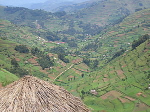
Kabale District is a highland district. The district covers 1827 square kilometre. The topography is mainly green, interlocking and heavily cultivated hills with spectacular valleys. The altitude of the district ranges between 1219 metres (3,999.3 ft) and 2347 metres (7,700.1 ft) above sea level. This altitude makes it colder than the rest of the country. Temperatures average about 18 °C (64.4 °F) during the day and fall to about 10 °C (50 °F) at night. The relative humidity is between 90% and 100% in the morning and decreases to between 42% and 75% in the afternoon, all the year around. The three counties of Rubanda, Rukiga and Ndorwa, together with KabaleKabale
Kabale is a city in Western Uganda. It is the 'chief town' of Kabale District and the district headquarters are located there. The district is named after the town.-Location:...
Municipality form Kabale District.
Population
The 2002 national census estimated the population of Kabale District at about 458,300, with an annual population growth rate of 3%. It is estimated that in 2010, the population of the district was approximately 580,600. See table below:{| style="font-size:100%;"
|-
| width="100%" align="center" | Kabale District Population Trends
|- valign="top"
|
{| class="wikitable sortable" style="margin-left:auto;margin-right:auto"
! style="width:2em;" |Year!! Estimated Population
|-
|2002||458,300
|-
|2003||472,100
|-
|2004||486,200
|-
|2005||500,800
|-
|2006||515,800
|-
|2007||531,300
|-
|2008||547,200
|-
|2009||563,700
|-
|2010||580,600
|-
|}
Kabale District is densely populated. With an area of 1827 square kilometre, the population density in the district in 2010 was estimated at 317 people per km² (823 people per mi²). The land is heavily fragmented. An average household has six to seven plots of land on several hills. The people are predominantly from the Bakiga
Bakiga
The Kiga people, or Abakiga , are an ethnic group located in northern Rwanda and southern Uganda. The Kiga speak a Bantu language called Rukiga. They are sometimes referred to as the Chiga or Kiga, while the singular form is Umukiga...
tribe, but also from Batwa
Great Lakes Twa
The Great Lakes Twa, also known as Abatwa or Ge-Sera, or in English Batwa, are a pygmy people who are generally assumed to be the oldest surviving population of the Great Lakes region of central Africa, though currently they live as a Bantu caste...
(Pygmies), the Banyarwanda
Banyarwanda
Banyarwanda actually means the people of Hutu, Tutsi and Batwah. Some lived on the present territory of the DRC before colonization, while others have migrated from neighboring Rwanda in waves. They live in the provinces of North Kivu and South Kivu, Democratic Republic of Congo....
and the Bahororo
Bahororo
The Hororo or Bahororo are a small nomadic Bantu tribe living in the north of the Kigezi District of Uganda. In 1905, they were described by a British officer as a "quiet, inoffensive people" who did not own cattle. They are made up mostly of the Hima...
(Toro) tribal clans.
Religion
- ChristianityChristianityChristianity is a monotheistic religion based on the life and teachings of Jesus as presented in canonical gospels and other New Testament writings...
: 98.5% - IslamIslamIslam . The most common are and . : Arabic pronunciation varies regionally. The first vowel ranges from ~~. The second vowel ranges from ~~~...
: 0.8% - OtherOtherThe Other or Constitutive Other is a key concept in continental philosophy; it opposes the Same. The Other refers, or attempts to refer, to that which is Other than the initial concept being considered...
: 0.3% - None : 0.4%
- Note: the category "Other" may include Orthodox ChristianityOrthodox ChristianityThe term Orthodox Christianity may refer to:* the Eastern Orthodox Church and its various geographical subdivisions...
and other Christians. - Source: Uganda Bureau of Statistics (2002)