
.gif)
K Street (Washington, D.C.)
Encyclopedia
K Street is a major thoroughfare in the United States
capital of Washington, D.C.
known as a center for numerous think tank
s, lobbyists, and advocacy group
s.
there are two unconnected streets designated as K Street. The term "K Street" almost always refers to the northern K Street.
The northern K Street, which carries a segment of U.S. Route 29
, begins in the city's Northwest quadrant
as K St. NW, just west of the abutment of the old Aqueduct Bridge
on the Georgetown
waterfront. The street travels east underneath the Whitehurst Freeway, crosses Rock Creek
and continues through downtown D.C. After its intersection with North Capitol Street
, the street's designation changes to K Street NE as it enters the Northeast
quadrant. The street ends at Florida Avenue
in the Near Northeast neighborhood, just south of Gallaudet University
.
The Georgetown section of the street was known as Water Street prior to the Georgetown street renaming
of 1895. West of 33rd Street NW, the United States Postal Service
still recognizes both "K Street" and "Water Street" in addresses. The westernmost end of K Street occupies the former right of way of the Georgetown Branch of the Baltimore and Ohio Railroad
. When that line was abandoned, K Street was extended west to the Washington Canoe Club. The rest of the Georgetown right of way is now occupied by the Capital Crescent Trail
, which begins at the terminus of K Street.
The southern K Street runs between the Potomac
and Anacostia
rivers, crossing the Southwest
and Southeast
quadrants (as K Street SW and K Street SE, respectively).
 K Street provides a major east-west thoroughfare for traffic through Washington, primarily from Mount Vernon Square
to the Whitehurst Freeway. The street continues through Georgetown under the Whitehurst Freeway; however most westbound traffic exits to the freeway. A portion of the street travels in a tunnel underneath Washington Circle
, allowing through traffic to avoid the circle
. Portions of the street are divided into both "local" (or service
) lanes and "express" lanes in both directions.
has been studying the conversion of K Street into part of a proposed busway
. The route would begin at Georgetown University
cross downtown
Washington on K Street, switch to Massachusetts Avenue at Mount Vernon Square
, and end at Union Station. Currently, the DC Circulator
provides service along most of the proposed route, although it must share right of way with other vehicles.
A streetcar line spanning from 26th St. NW to the H Street line's terminus at Union Station is planned as the next phase of DC's streetcar expansion
.
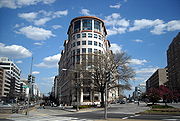
for Washington's lobbying
industry. Many of the major Washington lobbying firms are located on the section in Northwest Washington which passes from Georgetown through a portion of downtown D.C.
United States
The United States of America is a federal constitutional republic comprising fifty states and a federal district...
capital of Washington, D.C.
Washington, D.C.
Washington, D.C., formally the District of Columbia and commonly referred to as Washington, "the District", or simply D.C., is the capital of the United States. On July 16, 1790, the United States Congress approved the creation of a permanent national capital as permitted by the U.S. Constitution....
known as a center for numerous think tank
Think tank
A think tank is an organization that conducts research and engages in advocacy in areas such as social policy, political strategy, economics, military, and technology issues. Most think tanks are non-profit organizations, which some countries such as the United States and Canada provide with tax...
s, lobbyists, and advocacy group
Advocacy group
Advocacy groups use various forms of advocacy to influence public opinion and/or policy; they have played and continue to play an important part in the development of political and social systems...
s.
Location
In Washington's street gridGrid plan
The grid plan, grid street plan or gridiron plan is a type of city plan in which streets run at right angles to each other, forming a grid...
there are two unconnected streets designated as K Street. The term "K Street" almost always refers to the northern K Street.
The northern K Street, which carries a segment of U.S. Route 29
U.S. Route 29 in the District of Columbia
U.S. Route 29 passes through the District of Columbia between Arlington, Virginia, and Silver Spring, Maryland, predominantly along surface streets.-Route description:...
, begins in the city's Northwest quadrant
Washington, D.C. (northwest)
Northwest is the northwestern quadrant of Washington, D.C., the capital of the United States, and is located north of the National Mall and west of North Capitol Street...
as K St. NW, just west of the abutment of the old Aqueduct Bridge
Potomac Aqueduct Bridge
The Aqueduct Bridge was a bridge between Georgetown, Washington, D.C., and Rosslyn, Virginia, in Arlington County. It was built to transport cargo-carrying boats on the Chesapeake and Ohio Canal in Georgetown across the Potomac River to the Alexandria Canal...
on the Georgetown
Georgetown, Washington, D.C.
Georgetown is a neighborhood located in northwest Washington, D.C., situated along the Potomac River. Founded in 1751, the port of Georgetown predated the establishment of the federal district and the City of Washington by 40 years...
waterfront. The street travels east underneath the Whitehurst Freeway, crosses Rock Creek
Rock Creek (Potomac River)
Rock Creek is a free-flowing tributary of the Potomac River, which empties into the Atlantic Ocean via the Chesapeake Bay. The creek is long, with a drainage area of about...
and continues through downtown D.C. After its intersection with North Capitol Street
North Capitol Street
North Capitol Street is a street in Washington, D.C. that separates the Northwest and Northeast quadrants of the city. The street begins at D Street due north of the United States Capitol and continues northward 4½ miles to Nicholson Street where it is interrupted by Fort Slocum Park and the...
, the street's designation changes to K Street NE as it enters the Northeast
Washington, D.C. (northeast)
Northeast is the northeastern quadrant of Washington, D.C., the capital of the United States, and is located north of East Capitol Street and east of North Capitol Street...
quadrant. The street ends at Florida Avenue
Florida Avenue (Washington, D.C.)
Florida Avenue is a major street in Washington, D.C. It was originally named Boundary Street, because it formed the northern boundary of Pierre L'Enfant's original plan for the Federal City...
in the Near Northeast neighborhood, just south of Gallaudet University
Gallaudet University
Gallaudet University is a federally-chartered university for the education of the deaf and hard of hearing, located in the District of Columbia, U.S...
.
The Georgetown section of the street was known as Water Street prior to the Georgetown street renaming
Georgetown street renaming
The Georgetown street renaming occurred as a result of an 1895 act of the United States Congress that ended even the nominal independence of Georgetown from Washington, D.C. The Act required, inter alia, that the street names in Georgetown be changed to conform to the street naming system in use...
of 1895. West of 33rd Street NW, the United States Postal Service
United States Postal Service
The United States Postal Service is an independent agency of the United States government responsible for providing postal service in the United States...
still recognizes both "K Street" and "Water Street" in addresses. The westernmost end of K Street occupies the former right of way of the Georgetown Branch of the Baltimore and Ohio Railroad
Baltimore and Ohio Railroad
The Baltimore and Ohio Railroad was one of the oldest railroads in the United States and the first common carrier railroad. It came into being mostly because the city of Baltimore wanted to compete with the newly constructed Erie Canal and another canal being proposed by Pennsylvania, which...
. When that line was abandoned, K Street was extended west to the Washington Canoe Club. The rest of the Georgetown right of way is now occupied by the Capital Crescent Trail
Capital Crescent Trail
The Capital Crescent Trail is an long, shared-use rail trail that runs from Georgetown in Washington, D.C., to Silver Spring, Maryland. The portion from Bethesda to Silver Spring is also called the Georgetown Branch Trail but is recognized as the Future Capital Crescent Trail.The Capital Crescent...
, which begins at the terminus of K Street.
The southern K Street runs between the Potomac
Potomac River
The Potomac River flows into the Chesapeake Bay, located along the mid-Atlantic coast of the United States. The river is approximately long, with a drainage area of about 14,700 square miles...
and Anacostia
Anacostia River
The Anacostia River is a river in the Mid Atlantic region of the United States. It flows from Prince George's County in Maryland into Washington, D.C., where it joins with the Washington Channel to empty into the Potomac River at Buzzard Point. It is approximately long...
rivers, crossing the Southwest
Washington, D.C. (southwest)
Southwest is the southwestern quadrant of Washington, D.C., the capital of the United States, and is located south of the National Mall and west of South Capitol Street. It is the smallest quadrant of the city. Southwest is small enough that it is frequently referred to as a neighborhood in and of...
and Southeast
Washington, D.C. (southeast)
Southeast is the southeastern quadrant of Washington, D.C., the capital of the United States, and is located south of East Capitol Street and east of South Capitol Street. It includes the Capitol Hill and Anacostia neighborhoods, the Navy Yard, the Marine Barracks, the Anacostia River waterfront,...
quadrants (as K Street SW and K Street SE, respectively).
Current
Mount Vernon Square
Mount Vernon Square is a city square in the Northwest quadrant of Washington, D.C. It is located where the following streets would otherwise intersect: Massachusetts Avenue, New York Avenue, K Street, and 8th Street NW....
to the Whitehurst Freeway. The street continues through Georgetown under the Whitehurst Freeway; however most westbound traffic exits to the freeway. A portion of the street travels in a tunnel underneath Washington Circle
Washington Circle
Washington Circle is a traffic circle in the Northwest quadrant of Washington, D.C., United States. It is the intersection of 23rd Street, K Street, New Hampshire Avenue, and Pennsylvania Avenue, N.W., on the border of the Foggy Bottom and West End neighborhoods. The through lanes of K Street...
, allowing through traffic to avoid the circle
Traffic circle
A traffic circle or rotary is a type of circular intersection in which traffic must travel in one direction around a central island. In some countries, traffic entering the circle has the right-of-way and drivers in the circle must yield. In many other countries, traffic entering the circle must...
. Portions of the street are divided into both "local" (or service
Frontage road
A frontage road is a non-limited access road running parallel to a higher-speed road, usually a freeway, and feeding it at appropriate points of access...
) lanes and "express" lanes in both directions.
Proposed
The Washington Metropolitan Area Transit AuthorityWashington Metropolitan Area Transit Authority
The Washington Metropolitan Area Transit Authority is a tri-jurisdictional government agency that operates transit service in the Washington, D.C. metropolitan area, including the Metrorail, Metrobus and MetroAccess...
has been studying the conversion of K Street into part of a proposed busway
Busway
Busway may refer to several things:Transport technology* Bus rapid transit, bus systems including some elements of trams or metro systems* Guided busway, concrete tracks exclusively for modified busesTransport systems...
. The route would begin at Georgetown University
Georgetown University
Georgetown University is a private, Jesuit, research university whose main campus is in the Georgetown neighborhood of Washington, D.C. Founded in 1789, it is the oldest Catholic university in the United States...
cross downtown
Downtown Washington, D.C.
Downtown is a neighborhood of Washington, D.C., as well as a colloquial name for the central business district in the northwest quadrant of the city. Geographically, the area extends roughly five to six blocks west, northwest, north, northeast, and east of the White House...
Washington on K Street, switch to Massachusetts Avenue at Mount Vernon Square
Mount Vernon Square
Mount Vernon Square is a city square in the Northwest quadrant of Washington, D.C. It is located where the following streets would otherwise intersect: Massachusetts Avenue, New York Avenue, K Street, and 8th Street NW....
, and end at Union Station. Currently, the DC Circulator
DC Circulator
The DC Circulator is a bus system in Washington, D.C. The system is a public-private partnership between the District of Columbia Department of Transportation, the Washington Metropolitan Area Transit Authority, and DC Surface Transit, Inc., operated by First Transit.The concept of a separate...
provides service along most of the proposed route, although it must share right of way with other vehicles.
A streetcar line spanning from 26th St. NW to the H Street line's terminus at Union Station is planned as the next phase of DC's streetcar expansion
DC Streetcar
The DC Streetcar is a surface light rail and streetcar network under construction in Washington, D.C. The streetcars will be the first to run in the District of Columbia since the dismantling of the previous streetcar system in 1962...
.
Lobbying
"K Street" is the common and often derogatory metonymMetonymy
Metonymy is a figure of speech used in rhetoric in which a thing or concept is not called by its own name, but by the name of something intimately associated with that thing or concept...
for Washington's lobbying
Lobbying
Lobbying is the act of attempting to influence decisions made by officials in the government, most often legislators or members of regulatory agencies. Lobbying is done by various people or groups, from private-sector individuals or corporations, fellow legislators or government officials, or...
industry. Many of the major Washington lobbying firms are located on the section in Northwest Washington which passes from Georgetown through a portion of downtown D.C.