

Jungfrau
Encyclopedia
The Jungfrau is one of the main summits in the Bernese Alps
, situated between the cantons of Valais
and Bern in Switzerland
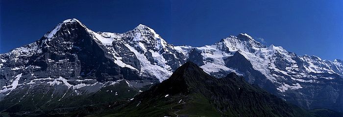
. Together with the Eiger
and Mönch
, the Jungfrau forms a massive wall overlooking the Bernese Oberland
and is considered one of the most emblematic sights of the Swiss Alps
.
The summit was first reached on August 3, 1811 by the Meyer brothers of Aarau
and two chamois
hunters from Valais. The ascent followed a long expedition over the glaciers and high passes of the Bernese Alps. It was not until 1865 that a more direct route on the northern side was opened.
The construction of the Jungfraujoch
railway east to the summit in the early 20th century made the area one of the most-visited places in the Alps. Along with the Aletsch Glacier
to the south, the Jungfrau is part of the Jungfrau-Aletsch Protected Area
, which was declared a World Heritage Site
in 2001.
after the nearby Finsteraarhorn
and Aletschhorn
, respectively 12 and 8 km away. But from Lake Thun
, and the greater part of the canton of Bern, it is the most conspicuous and the nearest of the Oberland peaks
, and the extreme steepness of the north face, secured for it an early reputation for inaccessibility.
The Jungfrau is the westernmost and highest point of a gigantic 10 km wall dominating the valleys of Lauterbrunnen
and Grindelwald
. The wall is formed by the alignment of some of the most distinctive north faces in the Alps, with the Mönch
(4,107 m) and Eiger
(3,970 m) to the east of the Jungfrau, and overlooks the valleys to its north by a height of up to 3 km. The Jungfrau is approximately 6 km from the Eiger; with the summit of the Mönch between the two mountains, 3.5 km from the Jungfrau. The wall is extended to the east by the Fiescherwand and to the west by the Lauterbrunnen Wall
.
The difference of altitude between the deep valley of Lauterbrunnen (800 m) and the summit is particularly visible from the area of Mürren
. From the valley floor, west of the massif
, the altitude gain is more than 3 km for a horizontal distance of 4 km.
The landscapes around the Jungfrau are extremely contrasted. Instead of the vertiginous precipices of the north-west, the south-east side emerges from the upper snows of the Aletsch Glacier
at around 3,500 metres. The 20 km long valley of Aletsch on the south-east is completely uninhabited and also surrounded by other similar glacier valleys. The whole area constitutes the largest glaciated area in the Alps as well as in Europe.
, with several servants and a porter picked up at Guttannen
, having reached the Valais
by way of the Grimsel
, crossed the Beich Pass, a glacier pass over the Oberaletsch Glacier
, to the head of the Lötschen valley
. There they added two local chamois hunters, Alois Volken and Joseph Bortis, to their party and traversed the Lötschenlücke
before reaching the Aletschfirn (the west branch of the Aletsch Glacier
), where they established the base camp, north of the Aletschhorn
. After the Guttannen porter was sent back alone over the Lötschenlücke, the party finally reached the summit of the Jungfrau by the Rottalsattel on August 3. They then recrossed the two passes named to their point of departure in Valais, and went home again over the Grimsel.
The journey was a most extraordinary one for the time, and some persons threw doubts on its complete success. To settle these another expedition was undertaken in 1812. In this the two sons, Rudolf (1791–1833) and Gottlieb (1793–1829), of Johann Rudolf Meyer, played the chief parts. After an unsuccessful attempt, defeated by bad weather, in the course of which the Oberaarjoch
was crossed twice (this route being much more direct than the long detour through the Lötschental), Rudolf, with the two Valais hunters (Alois Volker and Joseph Bortis), a Guttannen porter named Arnold Abbühl, and a Hasle man, bivouacked on a depression on the southeast ridge of the Finsteraarhorn
. Next day (August 16) the whole party attempted the ascent of the Finsteraarhorn from the Studer névé on the east by way of the southeast ridge, but Meyer, exhausted, remained behind. The following day the party crossed the Grünhornlücke to the Aletsch Glacier, but bad weather then put an end to further projects. At a bivouac, probably just opposite the present Konkordia Hut
, the rest of the party, having come over the Oberaarjoch and the Grünhornlücke, joined the Finsteraarhorn party. Gottlieb, Rudolf's younger brother, had more patience than the rest and remained longer at the huts near the Märjelensee
, where the adventurers had taken refuge. He could make the second ascent (September 3) of the Jungfrau, the Rottalsattel being reached from the east side as is now usual, and his companions being the two Valais hunters.
The third ascent dates from 1828, when several men from Grindelwald, headed by Peter Baumann, planted their flag upon the summit. Next came the ascent by Louis Agassiz
, James David Forbes
, Heath, Desor
, and Duchatelier in 1841, recounted by Desor in his Excursions et Séjours dans les Glaciers. Gottlieb Samuel Studer
published an account of the next ascent made by himself and Bürki in 1842. In 1863, a party consisting of John Tyndall
, J. J. Hornby, and T. H. Philpott, successfully reached the summit and returned to the base camp of the Faulberg (located near the actual position of the Konkordia Hut
) in less than 11 hours.. In the same year Mrs Stephen Winkworth became the first woman to climb the Jungfrau. She also slept overnight in the Faulberg cave prior to the ascent as there was no hut at that time.
 Before the construction of the Jungfraujoch railway tunnel, the approach from the glaciers on the south side was very long. The first direct route from the valley of Lauterbrunnen was opened in 1865 by Geoffrey Winthrop Young
, H. Brooke George with the guide Christian Almer
. They had to carry ladders with them in order to cross the many crevasses on the north flank. Having spent the night on the rocks of the Schneehorn (3,402 m) they gained next morning the Silberlücke, the depression between the Jungfrau and Silberhorn
, and thence in little more than 3 hours reached the summit. Descending to the Aletsch Glacier they crossed the Mönchsjoch, and passed a second night on the rocks, reaching Grindelwald next day. This route became a usual until the opening of the Jungfraujoch.
The first winter ascent was made on 23 January 1874, by Meta Brevoort
and W. A. B. Coolidge
with guides Christian and Ulrich Almer. They used a sled to reach the upper Aletsch Glacier, and were accompanied by Miss Brevoort's favorite dog, Tschingel.
The Jungfrau was climbed via the west side for the first time in 1885 by Fritz and Heinrich von Allmen, Ulrich Brunner, Fritz Graf, Karl Schlunegger and Johann Stäger—all from Wengen. They ascended the Rottal ridge (Innere Rottalgrat) and reached the summit on 21 September. The more difficult and dangerous northeast ridge that connects the summit from the Jungfraujoch
was first climbed on 30 July 1911 by Albert Weber and Hans Schlunegger.
In July 2007 six Swiss Army recruits, part of the Mountain Specialists Division 1, died in an accident on the normal route. Although the causes of the deaths was not immediately clear, a report by the Swiss Federal Institute for Snow and Avalanche Research concluded that the avalanche risk was unusually high due to recent snowfall, and that there was "no other reasonable explanation" other than an avalanche for the incident.
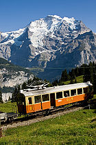 Once difficult to access, the Jungfraubahn
cog railway
now goes to the Jungfraujoch railway station
at 3454 m (11,332 ft), the highest in Europe. The Jungfraujoch is the lowest pass between the Jungfrau and Mönch.
In 1893 Adolf Guyer-Zeller
conceived of the idea for a railway tunnel to the Jungfraujoch to make the glaciated areas on the south more accessible. The building of the tunnel took 16 years and the summit station was not opened before 1912. The goal was in fact to reach the summit of the Jungfrau with an elevator from the highest railway station inside the mountain. The complete project was not realized because of the outbreak of the World War I
.
 The train into the mountain leaves from Kleine Scheidegg
, which can be reached by trains from Grindelwald
and Lauterbrunnen
via Wengen
. The train enters the tunnel running eastward through the Eiger shortly above Kleine Scheidegg. Before arriving at the Jungfraujoch, it stops for a few minutes at two other stations, Eigerwand (on the north face of the Eiger) and Eismeer (on the south side), where passengers can see through the holes excavated from the mountain. The journey from Kleine Scheidegg to Jungfraujoch takes approximately 50 minutes including the stops; the downhill return journey taking only 35 minutes.
A large complex of tunnels and buildings has been constructed at the Jungfraujoch, mostly into the south side of the Mönch. There is a hotel, two restaurants, an observatory, a research station, a small cinema, a ski school, and the "Ice Palace", a collection of elaborate ice sculpture
s. Another tunnel leads outside to a flat, snow-covered area, where one can walk around and look down to the Konkordiaplatz
and the Aletsch Glacier
, as well as the surrounding mountains.
Apart from the Jungfraujoch, many facilities have been built in the two valleys north of the Jungfrau (the commonly named Jungfrau Region). In 1908, the first public cable car in the world opened at the foot of the Wetterhorn
, but was closed 7 years later. The Schilthorn
above Mürren
or the Männlichen
above Wengen offer good views of the Jungfrau and other summits.
as the difference of altitude between the railway stations of Interlaken and Jungfraujoch is almost 3 km.
The final section of the climb is accomplished along one of the longest and sharpest arêtes of frozen snow to be found in the Alps, beyond which the eye plunges abruptly down a precipice 3.000 ft. in height into the depths of the Rottal, on the west of the Jungfrau. With perfect steadiness and first-rate guides there is no danger, unless too early in the season, or soon after a heavy fall of fresh snow. When it is necessary to cut steps all the way in hard frozen névé, the work is very laborious, and 3 hours may be consumed in ascending the 725 ft. that separate the Sattel from the summit. Some rocks jut out close to the top, but the actual peak consists of a nearly level ridge of frozen snow falling away on either side like a house-top with an excessively steep roof. The view, on one side, commands the icy plains of the Aletsch Glacier, and the highest alpine peaks far and near; on the other overlooks populous valleys that lie at a depth of 2 miles below the spectator's feet.
Bernese Alps
The Bernese Alps are a group of mountain ranges in the western part of the Alps, in Switzerland. Although the name suggests that they are located in the Bernese Oberland region of the canton of Bern, portions of the Bernese Alps are in the adjacent cantons of Valais, Lucerne, Obwalden, Fribourg and...
, situated between the cantons of Valais
Valais
The Valais is one of the 26 cantons of Switzerland in the southwestern part of the country, around the valley of the Rhône from its headwaters to Lake Geneva, separating the Pennine Alps from the Bernese Alps. The canton is one of the drier parts of Switzerland in its central Rhône valley...
and Bern in Switzerland
Switzerland
Switzerland name of one of the Swiss cantons. ; ; ; or ), in its full name the Swiss Confederation , is a federal republic consisting of 26 cantons, with Bern as the seat of the federal authorities. The country is situated in Western Europe,Or Central Europe depending on the definition....
. Together with the Eiger
Eiger
The Eiger is a mountain in the Bernese Alps in Switzerland. It is the easternmost peak of a ridge crest that extends across the Mönch to the Jungfrau at 4,158 m...
and Mönch
Mönch
The Mönch is a mountain in the Bernese Alps, in Switzerland. Together with the Eiger and the Jungfrau it forms a highly recognisable group of mountains visible from far away....
, the Jungfrau forms a massive wall overlooking the Bernese Oberland
Bernese Oberland
The Bernese Oberland is the higher part of the canton of Bern, Switzerland, in the southern end of the canton: The area around Lake Thun and Lake Brienz, and the valleys of the Bernese Alps .The flag of the Bernese Oberland consists of a black eagle in a gold field The Bernese Oberland (Bernese...
and is considered one of the most emblematic sights of the Swiss Alps
Swiss Alps
The Swiss Alps are the portion of the Alps mountain range that lies within Switzerland. Because of their central position within the entire Alpine range, they are also known as the Central Alps....
.
The summit was first reached on August 3, 1811 by the Meyer brothers of Aarau
Aarau
Aarau is the capital of the northern Swiss canton of Aargau. The city is also the capital of the district of Aarau. It is German-speaking and predominantly Protestant. Aarau is situated on the Swiss plateau, in the valley of the Aar, on the river's right bank, and at the southern foot of the Jura...
and two chamois
Chamois
The chamois, Rupicapra rupicapra, is a goat-antelope species native to mountains in Europe, including the Carpathian Mountains of Romania, the European Alps, the Tatra Mountains, the Balkans, parts of Turkey, and the Caucasus. The chamois has also been introduced to the South Island of New Zealand...
hunters from Valais. The ascent followed a long expedition over the glaciers and high passes of the Bernese Alps. It was not until 1865 that a more direct route on the northern side was opened.
The construction of the Jungfraujoch
Jungfraujoch
The Jungfraujoch is a col or saddle between the Mönch and the Jungfrau in the Bernese Alps on the boundary between the cantons of Bern and Valais, inside the Jungfrau-Aletsch Protected Area....
railway east to the summit in the early 20th century made the area one of the most-visited places in the Alps. Along with the Aletsch Glacier
Aletsch Glacier
The Aletsch Glacier or Great Aletsch Glacier is the largest glacier in the Alps. It has a length of about and covers more than in the eastern Bernese Alps in the Swiss canton of Valais...
to the south, the Jungfrau is part of the Jungfrau-Aletsch Protected Area
Jungfrau-Aletsch Protected Area
The Jungfrau-Aletsch protected area is located in south-western Switzerland between the cantons of Berne and Valais. It is a mountainous region in the easternmost side of the Bernese Alps, containing the northern wall of Jungfrau and Eiger, and the largest glaciated area in western Eurasia,...
, which was declared a World Heritage Site
World Heritage Site
A UNESCO World Heritage Site is a place that is listed by the UNESCO as of special cultural or physical significance...
in 2001.
Geographic setting
The Jungfrau is the third highest mountain of the Bernese AlpsBernese Alps
The Bernese Alps are a group of mountain ranges in the western part of the Alps, in Switzerland. Although the name suggests that they are located in the Bernese Oberland region of the canton of Bern, portions of the Bernese Alps are in the adjacent cantons of Valais, Lucerne, Obwalden, Fribourg and...
after the nearby Finsteraarhorn
Finsteraarhorn
The Finsteraarhorn is the highest mountain in the Bernese Alps and the highest mountain in the canton of Berne. It is also the highest summit in the Alps lying outside the main chain, or watershed. The Finsteraarhorn is the ninth highest and third most prominent peak in the Alps...
and Aletschhorn
Aletschhorn
The Aletschhorn is a mountain in the Alps in Switzerland, lying within the Jungfrau-Aletsch region, which has been designated a World Heritage Site by UNESCO...
, respectively 12 and 8 km away. But from Lake Thun
Lake Thun
Lake Thun is an Alpine lake in the Bernese Oberland in Switzerland. It took its name from the city of Thun, on its northern shore.Lake Thun's approximately 2,500 km² large catchment area frequently causes local flooding after heavy rainfalls...
, and the greater part of the canton of Bern, it is the most conspicuous and the nearest of the Oberland peaks
Bernese Oberland
The Bernese Oberland is the higher part of the canton of Bern, Switzerland, in the southern end of the canton: The area around Lake Thun and Lake Brienz, and the valleys of the Bernese Alps .The flag of the Bernese Oberland consists of a black eagle in a gold field The Bernese Oberland (Bernese...
, and the extreme steepness of the north face, secured for it an early reputation for inaccessibility.
The Jungfrau is the westernmost and highest point of a gigantic 10 km wall dominating the valleys of Lauterbrunnen
Lauterbrunnen
Lauterbrunnen is a municipality in the Interlaken-Oberhasli administrative district in the canton of Bern in Switzerland.The municipality lies in the Lauterbrunnen Valley and comprises the villages Lauterbrunnen, Wengen, Mürren, Gimmelwald, Stechelberg and Isenfluh...
and Grindelwald
Grindelwald
Grindelwald is a municipality in the Interlaken-Oberhasli administrative district in the canton of Bern in Switzerland. The village is located at above sea level in the Bernese Alps.-Winter sports:...
. The wall is formed by the alignment of some of the most distinctive north faces in the Alps, with the Mönch
Mönch
The Mönch is a mountain in the Bernese Alps, in Switzerland. Together with the Eiger and the Jungfrau it forms a highly recognisable group of mountains visible from far away....
(4,107 m) and Eiger
Eiger
The Eiger is a mountain in the Bernese Alps in Switzerland. It is the easternmost peak of a ridge crest that extends across the Mönch to the Jungfrau at 4,158 m...
(3,970 m) to the east of the Jungfrau, and overlooks the valleys to its north by a height of up to 3 km. The Jungfrau is approximately 6 km from the Eiger; with the summit of the Mönch between the two mountains, 3.5 km from the Jungfrau. The wall is extended to the east by the Fiescherwand and to the west by the Lauterbrunnen Wall
Lauterbrunnen Wall
The Lauterbrunnen Wall is a north-west-facing mountain wall in the Bernese Alps in Switzerland. It runs for 8 kilometres from the Gletscherhorn in the east, through the Ebnefluh, , the Mittaghorn and the Grosshorn , to the Lauterbrunnen Breithorn in the west, where the wall comes to an end at...
.
The difference of altitude between the deep valley of Lauterbrunnen (800 m) and the summit is particularly visible from the area of Mürren
Mürren
Mürren is a traditional Walser mountain village in Bernese Oberland, Switzerland, at an elevation of 1,650 m above sea level and unreachable by public road....
. From the valley floor, west of the massif
Massif
In geology, a massif is a section of a planet's crust that is demarcated by faults or flexures. In the movement of the crust, a massif tends to retain its internal structure while being displaced as a whole...
, the altitude gain is more than 3 km for a horizontal distance of 4 km.
The landscapes around the Jungfrau are extremely contrasted. Instead of the vertiginous precipices of the north-west, the south-east side emerges from the upper snows of the Aletsch Glacier
Aletsch Glacier
The Aletsch Glacier or Great Aletsch Glacier is the largest glacier in the Alps. It has a length of about and covers more than in the eastern Bernese Alps in the Swiss canton of Valais...
at around 3,500 metres. The 20 km long valley of Aletsch on the south-east is completely uninhabited and also surrounded by other similar glacier valleys. The whole area constitutes the largest glaciated area in the Alps as well as in Europe.
Climbing history
In 1811, the brothers Johann Rudolf (1768–1825) and Hieronymus Meyer, sons of Johann Rudolf Meyer (1739–1813), the head of a rich merchant family of AarauAarau
Aarau is the capital of the northern Swiss canton of Aargau. The city is also the capital of the district of Aarau. It is German-speaking and predominantly Protestant. Aarau is situated on the Swiss plateau, in the valley of the Aar, on the river's right bank, and at the southern foot of the Jura...
, with several servants and a porter picked up at Guttannen
Guttannen
Guttannen is a municipality in the Interlaken-Oberhasli administrative district in the canton of Bern in Switzerland.- Geography :Guttannen lies in the Bernese Oberland near Grimsel Pass. It is the highest settlement in the Haslital...
, having reached the Valais
Valais
The Valais is one of the 26 cantons of Switzerland in the southwestern part of the country, around the valley of the Rhône from its headwaters to Lake Geneva, separating the Pennine Alps from the Bernese Alps. The canton is one of the drier parts of Switzerland in its central Rhône valley...
by way of the Grimsel
Grimsel Pass
Grimsel Pass is a Swiss high mountain pass.-Position:It connects the valley of the Rhone River in the canton of Valais and the Haslital in the canton of Bern....
, crossed the Beich Pass, a glacier pass over the Oberaletsch Glacier
Oberaletsch Glacier
The Oberaletsch Glacier is a valley glacier on the south side of the Bernese Alps, in the canton of Valais. It has a length of with an average width of just under and an area of about ....
, to the head of the Lötschen valley
Lötschental
The Lötschental is the largest valley on the northern side of the Rhône valley in the canton of Valais in Switzerland. It lies in the Bernese Alps, with the river Lonza running down the length of the valley from its source within the Langgletscher....
. There they added two local chamois hunters, Alois Volken and Joseph Bortis, to their party and traversed the Lötschenlücke
Lötschenlücke
The Lötschenlücke is a high mountain pass in the Bernese Alps, connecting the Lötschental valley to the Aletsch Glacier in the canton of Valais in Switzerland. A hut is located above the col at 3240 m....
before reaching the Aletschfirn (the west branch of the Aletsch Glacier
Aletsch Glacier
The Aletsch Glacier or Great Aletsch Glacier is the largest glacier in the Alps. It has a length of about and covers more than in the eastern Bernese Alps in the Swiss canton of Valais...
), where they established the base camp, north of the Aletschhorn
Aletschhorn
The Aletschhorn is a mountain in the Alps in Switzerland, lying within the Jungfrau-Aletsch region, which has been designated a World Heritage Site by UNESCO...
. After the Guttannen porter was sent back alone over the Lötschenlücke, the party finally reached the summit of the Jungfrau by the Rottalsattel on August 3. They then recrossed the two passes named to their point of departure in Valais, and went home again over the Grimsel.
The journey was a most extraordinary one for the time, and some persons threw doubts on its complete success. To settle these another expedition was undertaken in 1812. In this the two sons, Rudolf (1791–1833) and Gottlieb (1793–1829), of Johann Rudolf Meyer, played the chief parts. After an unsuccessful attempt, defeated by bad weather, in the course of which the Oberaarjoch
Oberaarjoch
The Oberaarjoch is a high mountain pass across the eastern Bernese Alps, connecting the Fiescher Glacier in the canton of Valais with the Oberaar Glacier in the canton of Berne in Switzerland....
was crossed twice (this route being much more direct than the long detour through the Lötschental), Rudolf, with the two Valais hunters (Alois Volker and Joseph Bortis), a Guttannen porter named Arnold Abbühl, and a Hasle man, bivouacked on a depression on the southeast ridge of the Finsteraarhorn
Finsteraarhorn
The Finsteraarhorn is the highest mountain in the Bernese Alps and the highest mountain in the canton of Berne. It is also the highest summit in the Alps lying outside the main chain, or watershed. The Finsteraarhorn is the ninth highest and third most prominent peak in the Alps...
. Next day (August 16) the whole party attempted the ascent of the Finsteraarhorn from the Studer névé on the east by way of the southeast ridge, but Meyer, exhausted, remained behind. The following day the party crossed the Grünhornlücke to the Aletsch Glacier, but bad weather then put an end to further projects. At a bivouac, probably just opposite the present Konkordia Hut
Konkordia Hut
The Konkordia Hut is a mountain hut located in the Bernese Alps in the canton of Valais in Switzerland. It is owned by the Swiss Alpine Club....
, the rest of the party, having come over the Oberaarjoch and the Grünhornlücke, joined the Finsteraarhorn party. Gottlieb, Rudolf's younger brother, had more patience than the rest and remained longer at the huts near the Märjelensee
Märjelensee
Märjelensee is a lake in the canton of Valais, Switzerland. It formed on the eastern side of the Aletsch Glacier in the 19th century....
, where the adventurers had taken refuge. He could make the second ascent (September 3) of the Jungfrau, the Rottalsattel being reached from the east side as is now usual, and his companions being the two Valais hunters.
The third ascent dates from 1828, when several men from Grindelwald, headed by Peter Baumann, planted their flag upon the summit. Next came the ascent by Louis Agassiz
Louis Agassiz
Jean Louis Rodolphe Agassiz was a Swiss paleontologist, glaciologist, geologist and a prominent innovator in the study of the Earth's natural history. He grew up in Switzerland and became a professor of natural history at University of Neuchâtel...
, James David Forbes
James David Forbes
James David Forbes was a Scottish physicist and glaciologist who worked extensively on the conduction of heat and seismology. Forbes was a resident of Edinburgh for most of his life, educated at the University and a professor there from 1833 until he became principal of the United College of St...
, Heath, Desor
Pierre Jean Édouard Desor
Pierre Jean Édouard Desor was a Swiss geologist. He associated in his early years with Louis Agassiz, studying palaeontology and glacial phenomena, and together with James David Forbes ascended the Jungfrau in 1841...
, and Duchatelier in 1841, recounted by Desor in his Excursions et Séjours dans les Glaciers. Gottlieb Samuel Studer
Gottlieb Samuel Studer
Gottlieb Samuel Studer was a Swiss mountaineer, Notary public and draughtsman.Studer was the son of Sigmund Gottlieb Studer...
published an account of the next ascent made by himself and Bürki in 1842. In 1863, a party consisting of John Tyndall
John Tyndall
John Tyndall FRS was a prominent Irish 19th century physicist. His initial scientific fame arose in the 1850s from his study of diamagnetism. Later he studied thermal radiation, and produced a number of discoveries about processes in the atmosphere...
, J. J. Hornby, and T. H. Philpott, successfully reached the summit and returned to the base camp of the Faulberg (located near the actual position of the Konkordia Hut
Konkordia Hut
The Konkordia Hut is a mountain hut located in the Bernese Alps in the canton of Valais in Switzerland. It is owned by the Swiss Alpine Club....
) in less than 11 hours.. In the same year Mrs Stephen Winkworth became the first woman to climb the Jungfrau. She also slept overnight in the Faulberg cave prior to the ascent as there was no hut at that time.
Geoffrey Winthrop Young
Geoffrey Winthrop Young D.Litt. was a British climber, poet and educator, and author of several notable books on mountaineering.-Mountaineering:...
, H. Brooke George with the guide Christian Almer
Christian Almer
thumb|220px|Christian AlmerChristian Almer was a Swiss mountain guide and the first ascentionist of many prominent mountains in the western Alps during the golden and silver ages of alpinism....
. They had to carry ladders with them in order to cross the many crevasses on the north flank. Having spent the night on the rocks of the Schneehorn (3,402 m) they gained next morning the Silberlücke, the depression between the Jungfrau and Silberhorn
Silberhorn
The Silberhorn is a pyramid-shaped mountain in the Bernese Alps, to the northwest of the Jungfrau of which it is a satellite peak.A first attempt to reach the summit of the Silberhorn was made in June 1863 by M. v. Fellenberg from the Stufensteinalp on the east side of the valley of Lauterbrunnen...
, and thence in little more than 3 hours reached the summit. Descending to the Aletsch Glacier they crossed the Mönchsjoch, and passed a second night on the rocks, reaching Grindelwald next day. This route became a usual until the opening of the Jungfraujoch.
The first winter ascent was made on 23 January 1874, by Meta Brevoort
Meta Brevoort
Marguerite "Meta" Brevoort , an American mountain climber, spent her early years in a Paris convent school. She made a number of important ascents in the Alps in the 1860s and 1870s, but was thwarted in her two greatest alpine ambitions: to be the first woman to climb the Matterhorn, and the first...
and W. A. B. Coolidge
W. A. B. Coolidge
William Augustus Brevoort Coolidge was an American historian, theologian and mountaineer.Coolidge was born in New York as the son of Frederic William Skinner Coolidge, a Boston merchant, and Elisabeth Neville Brevoort of the Netherlands. He studied history and law at St...
with guides Christian and Ulrich Almer. They used a sled to reach the upper Aletsch Glacier, and were accompanied by Miss Brevoort's favorite dog, Tschingel.
The Jungfrau was climbed via the west side for the first time in 1885 by Fritz and Heinrich von Allmen, Ulrich Brunner, Fritz Graf, Karl Schlunegger and Johann Stäger—all from Wengen. They ascended the Rottal ridge (Innere Rottalgrat) and reached the summit on 21 September. The more difficult and dangerous northeast ridge that connects the summit from the Jungfraujoch
Jungfraujoch
The Jungfraujoch is a col or saddle between the Mönch and the Jungfrau in the Bernese Alps on the boundary between the cantons of Bern and Valais, inside the Jungfrau-Aletsch Protected Area....
was first climbed on 30 July 1911 by Albert Weber and Hans Schlunegger.
In July 2007 six Swiss Army recruits, part of the Mountain Specialists Division 1, died in an accident on the normal route. Although the causes of the deaths was not immediately clear, a report by the Swiss Federal Institute for Snow and Avalanche Research concluded that the avalanche risk was unusually high due to recent snowfall, and that there was "no other reasonable explanation" other than an avalanche for the incident.
Jungfraujoch and tourism
Jungfraubahn
The Jungfraubahn is an gauge rack railway electrified at 3-phase 1,125 volts 50 Hertz, which runs 9 kilometres from Kleine Scheidegg to the highest railway station in Europe at Jungfraujoch...
cog railway
Rack railway
A rack-and-pinion railway is a railway with a toothed rack rail, usually between the running rails. The trains are fitted with one or more cog wheels or pinions that mesh with this rack rail...
now goes to the Jungfraujoch railway station
Train station
A train station, also called a railroad station or railway station and often shortened to just station,"Station" is commonly understood to mean "train station" unless otherwise qualified. This is evident from dictionary entries e.g...
at 3454 m (11,332 ft), the highest in Europe. The Jungfraujoch is the lowest pass between the Jungfrau and Mönch.
In 1893 Adolf Guyer-Zeller
Adolf Guyer-Zeller
Adolf Guyer-Zeller was a Swiss entrepreneur.He was the son of an owner of spinning mill and creator of a textile export trade in Zürich. After the death of his father, he led the company...
conceived of the idea for a railway tunnel to the Jungfraujoch to make the glaciated areas on the south more accessible. The building of the tunnel took 16 years and the summit station was not opened before 1912. The goal was in fact to reach the summit of the Jungfrau with an elevator from the highest railway station inside the mountain. The complete project was not realized because of the outbreak of the World War I
World War I
World War I , which was predominantly called the World War or the Great War from its occurrence until 1939, and the First World War or World War I thereafter, was a major war centred in Europe that began on 28 July 1914 and lasted until 11 November 1918...
.
Kleine Scheidegg
The Kleine Scheidegg is a high mountain pass below and between the Eiger and Lauberhorn peaks in the Bernese Oberland, Switzerland. It connects Grindelwald with Lauterbrunnen. The name means "minor watershed", even though it is actually higher than the neighbouring Grosse Scheidegg...
, which can be reached by trains from Grindelwald
Grindelwald
Grindelwald is a municipality in the Interlaken-Oberhasli administrative district in the canton of Bern in Switzerland. The village is located at above sea level in the Bernese Alps.-Winter sports:...
and Lauterbrunnen
Lauterbrunnen
Lauterbrunnen is a municipality in the Interlaken-Oberhasli administrative district in the canton of Bern in Switzerland.The municipality lies in the Lauterbrunnen Valley and comprises the villages Lauterbrunnen, Wengen, Mürren, Gimmelwald, Stechelberg and Isenfluh...
via Wengen
Wengen
Wengen may refer to:*Wengen, a village and winter resort in Switzerland*La Val, a commune in South Tyrol, Italy with the German name "Wengen"*in Germany:**Wengen , a village in the municipality of Nennslingen in Mittelfranken...
. The train enters the tunnel running eastward through the Eiger shortly above Kleine Scheidegg. Before arriving at the Jungfraujoch, it stops for a few minutes at two other stations, Eigerwand (on the north face of the Eiger) and Eismeer (on the south side), where passengers can see through the holes excavated from the mountain. The journey from Kleine Scheidegg to Jungfraujoch takes approximately 50 minutes including the stops; the downhill return journey taking only 35 minutes.
A large complex of tunnels and buildings has been constructed at the Jungfraujoch, mostly into the south side of the Mönch. There is a hotel, two restaurants, an observatory, a research station, a small cinema, a ski school, and the "Ice Palace", a collection of elaborate ice sculpture
Ice sculpture
Ice sculpture is a form of sculpture that uses ice as the raw material. Sculptures from ice can be abstract or realistic and can be functional or purely decorative...
s. Another tunnel leads outside to a flat, snow-covered area, where one can walk around and look down to the Konkordiaplatz
Konkordiaplatz
The Konkordiaplatz or Concordia , is a large flat area of snow and ice lying just to the south of the Jungfrau in the Bernese Alps in the Swiss canton of Valais. Its notable feature is that it is the junction of four large glaciers coming down from the Aletschfirn, the Jungfraufirn, the...
and the Aletsch Glacier
Aletsch Glacier
The Aletsch Glacier or Great Aletsch Glacier is the largest glacier in the Alps. It has a length of about and covers more than in the eastern Bernese Alps in the Swiss canton of Valais...
, as well as the surrounding mountains.
Apart from the Jungfraujoch, many facilities have been built in the two valleys north of the Jungfrau (the commonly named Jungfrau Region). In 1908, the first public cable car in the world opened at the foot of the Wetterhorn
Wetterhorn
The Wetterhorn is a mountain in the Swiss Alps close to the village of Grindelwald. First climbed in 1844, the 1854 ascent by Alfred Wills and party is more celebrated and is generally regarded to have marked the beginning of the golden age of alpinism.The mountain is composed of three distinct...
, but was closed 7 years later. The Schilthorn
Schilthorn
The Schilthorn is a 2,970 metre high summit in the Bernese Alps in Switzerland, above Mürren.It has a panoramic view which spans from the Titlis, Jungfrau, Mönch, Eiger, over the Bernese Alps and the Jura mountains up to the Vosges Mountains and the Black Forest...
above Mürren
Mürren
Mürren is a traditional Walser mountain village in Bernese Oberland, Switzerland, at an elevation of 1,650 m above sea level and unreachable by public road....
or the Männlichen
Männlichen
The Männlichen is a 2,343 metre mountain in the Swiss Alps located within the Canton of Berne.It can be reached from Wengen by the Luftseilbahn Wengen-Männlichen cable-car, or from Grindelwald using the Gondelbahn Grindelwald-Männlichen gondola. It then takes 15 minutes to walk to the summit...
above Wengen offer good views of the Jungfrau and other summits.
Climbing routes
The normal route follows the traces of the first climbers, but the long approach on the Aletsch Glacier is no longer necessary. From the area of the Jungfraujoch the route to the summit takes only a few hours. Most climbers starts from the Mönchsjoch Hut. After a traverse of the Jungfraufirn the route heads to the Rottalsattel (3,885 m), from where the southern ridge leads to the Jungfrau. It is not considered a very difficult climb but it can be dangerous on the upper section above the Rottalsattel, where most of the accidents happen. The use of the Jungfrau railway can cause some acclimatization troublesEffects of high altitude on humans
The effects of high altitude on humans are considerable. The percentage saturation of hemoglobin with oxygen determines the content of oxygen in our blood. After the human body reaches around 2,100 m above sea level, the saturation of oxyhemoglobin begins to plummet...
as the difference of altitude between the railway stations of Interlaken and Jungfraujoch is almost 3 km.
The final section of the climb is accomplished along one of the longest and sharpest arêtes of frozen snow to be found in the Alps, beyond which the eye plunges abruptly down a precipice 3.000 ft. in height into the depths of the Rottal, on the west of the Jungfrau. With perfect steadiness and first-rate guides there is no danger, unless too early in the season, or soon after a heavy fall of fresh snow. When it is necessary to cut steps all the way in hard frozen névé, the work is very laborious, and 3 hours may be consumed in ascending the 725 ft. that separate the Sattel from the summit. Some rocks jut out close to the top, but the actual peak consists of a nearly level ridge of frozen snow falling away on either side like a house-top with an excessively steep roof. The view, on one side, commands the icy plains of the Aletsch Glacier, and the highest alpine peaks far and near; on the other overlooks populous valleys that lie at a depth of 2 miles below the spectator's feet.