
Johnson's Shut-Ins State Park
Encyclopedia
Johnson's Shut-Ins State Park is a Missouri
state park on the East Fork Black River
consisting of 8550 acres (34.6 km²) in Reynolds County
. The park is jointly administered with adjoining Taum Sauk Mountain State Park
, and together the two parks cover 16050 acres (65 km²) in the St. Francois Mountains region of the Missouri Ozarks.
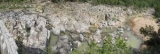
The term "shut-in
" refers to a place where the river's breadth is limited by hard rock that is resistant to erosion. In these shut-ins the river cascades in many rivulets over and around igneous rocks worn smooth over many eons. It is used by park visitors as a natural water park
when the water is not so high as to be dangerous.
and gases spewed into the air, then cooled, forming igneous rock
. Later, shallow seas covered the rock, depositing sedimentary rock
. The area was uplifted
and erosion
exposed the volcanic rock
. Waters of the East Fork Black River became confined, or "shut-in
," to a narrow channel. Water-borne sand and gravel cut deeply even into this erosion-resistant rock, carving pothole
s, chutes and canyon-like gorges.
mining
family. The family has continued over the years to donate funds for park improvements.
A one-fourth mile walkway takes visitors to an observation deck overlooking the shut-ins. Camping, hiking and swimming are popular pastimes, with rock climbing allowed by permit from Sept. 2 through the Thursday before Memorial Day weekend. Basic and electric campsites are available, along with a park store. All campsites are reservable. Total capacity in the day-use area is 100 vehicles. Pets are not allowed in the park.
An extension to the park provides an auto tour that passes by the ongoing recovery effort, as well as the recovered endangered fen
s area, terminating at a shaded overlook of the flood path accessible from the park entrance. From this one can walk a path through the boulder field created by the flood. The boulder field contains many examples of the minerals and rocks that make up the St. Francois Mountains of the Ozarks
.
A popular section of the Ozark trail
crosses the park.
reservoir atop a neighboring mountain. Part of the damage was the eradication of the park's campground, but being a weeknight in December, the campground was unoccupied; the only people at the park were the park's superintendent and his family; the family survived, sustaining some injuries. The park was closed because of the extent of the damage it received.
The park partly reopened in the summer of 2006 for limited day use, but due to dangerous conditions, swimming in the river and exploring the rock formations was prohibited. In 2009 the river and shut-ins were reopened for recreation in the water. A new campground is expected to open April 30, 2010. Park restoration and improvements are funded with $52 million of a $180 million settlement to the state from AmerenUE, the owner and operator of the failed reservoir.
Some areas of forest in the park and the surrounding region were severely damaged by the May 2009 derecho
windstorm. Straight-line wind speeds in this part of Reynolds County reached 60 to 70 mi/h (97 to 113 km/h) with microburst
s estimated up to 100 mi/h (161 km/h).
Missouri
Missouri is a US state located in the Midwestern United States, bordered by Iowa, Illinois, Kentucky, Tennessee, Arkansas, Oklahoma, Kansas and Nebraska. With a 2010 population of 5,988,927, Missouri is the 18th most populous state in the nation and the fifth most populous in the Midwest. It...
state park on the East Fork Black River
Black River (Arkansas)
The Black River is a tributary of the White River, about 300 mi long , in southeastern Missouri and northeastern Arkansas in the United States. Via the White River, it is part of the Mississippi River watershed...
consisting of 8550 acres (34.6 km²) in Reynolds County
Reynolds County, Missouri
Reynolds County is a county located in the northwestern portion of the Ozark Foothills Region in Southeast Missouri in the United States. As of the 2000 U.S. Census, the county's population was 6,689. A 2008 estimate, however, showed the population to be 6,388. Its county seat is Centerville...
. The park is jointly administered with adjoining Taum Sauk Mountain State Park
Taum Sauk Mountain State Park
Taum Sauk Mountain State Park is located in the Saint Francois Mountains in the Missouri Ozarks. It is centered around Taum Sauk Mountain, the highest point in the state....
, and together the two parks cover 16050 acres (65 km²) in the St. Francois Mountains region of the Missouri Ozarks.
The term "shut-in
Shut-in (river)
A shut-in is an Ozark term for a river that's naturally confined within a deep, narrow channel. The river becomes unnavigable even by canoe due to a the rapids and narrow channels produced as the stream encounters a more resistant rock that is more difficult to erode...
" refers to a place where the river's breadth is limited by hard rock that is resistant to erosion. In these shut-ins the river cascades in many rivulets over and around igneous rocks worn smooth over many eons. It is used by park visitors as a natural water park
Water park
A waterpark is an amusement park that features waterplay areas, such as water slides, splash pads, spraygrounds , lazy rivers, or other recreational bathing, swimming, and barefooting environments...
when the water is not so high as to be dangerous.
Geology
One and a half billion years ago, hot volcanic ashVolcanic ash
Volcanic ash consists of small tephra, which are bits of pulverized rock and glass created by volcanic eruptions, less than in diameter. There are three mechanisms of volcanic ash formation: gas release under decompression causing magmatic eruptions; thermal contraction from chilling on contact...
and gases spewed into the air, then cooled, forming igneous rock
Igneous rock
Igneous rock is one of the three main rock types, the others being sedimentary and metamorphic rock. Igneous rock is formed through the cooling and solidification of magma or lava...
. Later, shallow seas covered the rock, depositing sedimentary rock
Sedimentary rock
Sedimentary rock are types of rock that are formed by the deposition of material at the Earth's surface and within bodies of water. Sedimentation is the collective name for processes that cause mineral and/or organic particles to settle and accumulate or minerals to precipitate from a solution....
. The area was uplifted
Tectonic uplift
Tectonic uplift is a geological process most often caused by plate tectonics which increases elevation. The opposite of uplift is subsidence, which results in a decrease in elevation. Uplift may be orogenic or isostatic.-Orogenic uplift:...
and erosion
Erosion
Erosion is when materials are removed from the surface and changed into something else. It only works by hydraulic actions and transport of solids in the natural environment, and leads to the deposition of these materials elsewhere...
exposed the volcanic rock
Volcanic rock
Volcanic rock is a rock formed from magma erupted from a volcano. In other words, it is an igneous rock of volcanic origin...
. Waters of the East Fork Black River became confined, or "shut-in
Shut-in (river)
A shut-in is an Ozark term for a river that's naturally confined within a deep, narrow channel. The river becomes unnavigable even by canoe due to a the rapids and narrow channels produced as the stream encounters a more resistant rock that is more difficult to erode...
," to a narrow channel. Water-borne sand and gravel cut deeply even into this erosion-resistant rock, carving pothole
Pothole
A pothole is a type of disruption in the surface of a roadway where a portion of the road material has broken away, leaving a hole.- Formation :...
s, chutes and canyon-like gorges.
History and description
Most of the park, including the shut-ins and two miles of river frontage, was assembled over the course of 17 years and donated to the state in 1955 by Joseph Desloge (1889–1971), a St. Louis civic leader and conservationist from a prominent leadLead
Lead is a main-group element in the carbon group with the symbol Pb and atomic number 82. Lead is a soft, malleable poor metal. It is also counted as one of the heavy metals. Metallic lead has a bluish-white color after being freshly cut, but it soon tarnishes to a dull grayish color when exposed...
mining
Mining
Mining is the extraction of valuable minerals or other geological materials from the earth, from an ore body, vein or seam. The term also includes the removal of soil. Materials recovered by mining include base metals, precious metals, iron, uranium, coal, diamonds, limestone, oil shale, rock...
family. The family has continued over the years to donate funds for park improvements.
A one-fourth mile walkway takes visitors to an observation deck overlooking the shut-ins. Camping, hiking and swimming are popular pastimes, with rock climbing allowed by permit from Sept. 2 through the Thursday before Memorial Day weekend. Basic and electric campsites are available, along with a park store. All campsites are reservable. Total capacity in the day-use area is 100 vehicles. Pets are not allowed in the park.
An extension to the park provides an auto tour that passes by the ongoing recovery effort, as well as the recovered endangered fen
Fen
A fen is a type of wetland fed by mineral-rich surface water or groundwater. Fens are characterised by their water chemistry, which is neutral or alkaline, with relatively high dissolved mineral levels but few other plant nutrients...
s area, terminating at a shaded overlook of the flood path accessible from the park entrance. From this one can walk a path through the boulder field created by the flood. The boulder field contains many examples of the minerals and rocks that make up the St. Francois Mountains of the Ozarks
The Ozarks
The Ozarks are a physiographic and geologic highland region of the central United States. It covers much of the southern half of Missouri and an extensive portion of northwestern and north central Arkansas...
.
A popular section of the Ozark trail
Ozark Trail (hiking trail)
The Ozark Trail is a hiking, backpacking, and, in many places, biking and equestrian trail under construction in the Missouri Ozarks in the United States. It is intended to reach from St. Louis to Arkansas. Over of the trail have been completed as of 2008, and the estimated length when finished...
crosses the park.
Disasters
In late 2005 the park was devastated by a catastrophic flood caused by the failure of the Taum Sauk pumped storage plantTaum Sauk pumped storage plant
The Taum Sauk pumped storage plant is located in the St. Francois mountain region of the Missouri Ozarks approximately south of St. Louis near Lesterville, Missouri in Reynolds County. The pumped-storage hydroelectric plant, operated by the AmerenUE electric company, was designed to help...
reservoir atop a neighboring mountain. Part of the damage was the eradication of the park's campground, but being a weeknight in December, the campground was unoccupied; the only people at the park were the park's superintendent and his family; the family survived, sustaining some injuries. The park was closed because of the extent of the damage it received.
The park partly reopened in the summer of 2006 for limited day use, but due to dangerous conditions, swimming in the river and exploring the rock formations was prohibited. In 2009 the river and shut-ins were reopened for recreation in the water. A new campground is expected to open April 30, 2010. Park restoration and improvements are funded with $52 million of a $180 million settlement to the state from AmerenUE, the owner and operator of the failed reservoir.
Some areas of forest in the park and the surrounding region were severely damaged by the May 2009 derecho
May 2009 Southern Midwest derecho
The May 2009 Southern Midwest Derecho was an extreme progressive derecho and mesoscale convective vortex event that struck Southeastern Kansas, Southern Missouri, and Southwestern Illinois on May 8, 2009. Thirty-nine tornadoes, including two of EF3 strength on the Enhanced Fujita Scale, were...
windstorm. Straight-line wind speeds in this part of Reynolds County reached 60 to 70 mi/h (97 to 113 km/h) with microburst
Microburst
A microburst is a very localized column of sinking air, producing damaging divergent and straight-line winds at the surface that are similar to, but distinguishable from, tornadoes, which generally have convergent damage. There are two types of microbursts: wet microbursts and dry microbursts...
s estimated up to 100 mi/h (161 km/h).