
John Kilpatrick Turnpike
Encyclopedia
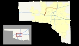
The John Kilpatrick Turnpike is a toll road
in Oklahoma City
, Oklahoma
that runs from Interstate 40 on its west side to I-35, where it then merges into the Turner Turnpike
(Interstate 44). The so-called 'outer loop' toll expressway, since it exists outside of the central Oklahoma City area, was constructed as a reliever for traffic wanting to avoid delays in the central city.
It costs $2.00 to drive the entire turnpike; customers using the Pikepass electronic toll system receive a slight discount. The turnpike was completed during the 1990s in two stages, the most recent being the leg that connects the turnpike to Interstate 40 near Yukon
.
On much of the east–west part of the turnpike, Memorial Road provides one-way frontage road
s.
Law enforcement along the John Kilpatrick Turnpike is provided by Oklahoma Highway Patrol
Troop YE, a special troop assigned to the turnpike.
Toll road
A toll road is a privately or publicly built road for which a driver pays a toll for use. Structures for which tolls are charged include toll bridges and toll tunnels. Non-toll roads are financed using other sources of revenue, most typically fuel tax or general tax funds...
in Oklahoma City
Oklahoma city
Oklahoma City is the capital and largest city of the U.S. state of Oklahoma.Oklahoma City may also refer to:*Oklahoma City metropolitan area*Downtown Oklahoma City*Uptown Oklahoma City*Oklahoma City bombing*Oklahoma City National Memorial...
, Oklahoma
Oklahoma
Oklahoma is a state located in the South Central region of the United States of America. With an estimated 3,751,351 residents as of the 2010 census and a land area of 68,667 square miles , Oklahoma is the 28th most populous and 20th-largest state...
that runs from Interstate 40 on its west side to I-35, where it then merges into the Turner Turnpike
Turner Turnpike
The Governor Roy J. Turner Turnpike is a toll road in central Oklahoma, connecting its two largest cities, Oklahoma City and Tulsa. It was authorized by the Oklahoma Legislature in 1947 and opened in May, 1953, it is the oldest of the state's ten turnpikes. The route is signed as Interstate 44 for...
(Interstate 44). The so-called 'outer loop' toll expressway, since it exists outside of the central Oklahoma City area, was constructed as a reliever for traffic wanting to avoid delays in the central city.
It costs $2.00 to drive the entire turnpike; customers using the Pikepass electronic toll system receive a slight discount. The turnpike was completed during the 1990s in two stages, the most recent being the leg that connects the turnpike to Interstate 40 near Yukon
Yukon, Oklahoma
Yukon is a city in Canadian County, Oklahoma, United States and is part of the Oklahoma City Metropolitan Area. The population was 22,709 at the 2010 census....
.
On much of the east–west part of the turnpike, Memorial Road provides one-way frontage road
Frontage road
A frontage road is a non-limited access road running parallel to a higher-speed road, usually a freeway, and feeding it at appropriate points of access...
s.
Law enforcement along the John Kilpatrick Turnpike is provided by Oklahoma Highway Patrol
Oklahoma Highway Patrol
The Oklahoma Highway Patrol is a major state law enforcement agency of the government of Oklahoma. It is a division of the Oklahoma Department of Public Safety. The Oklahoma Highway Patrol was legislatively created in 1937 due to the growing problem of motor vehicle accidents, the expansion of a...
Troop YE, a special troop assigned to the turnpike.
Exit list
| County | Location | Mile | Destinations | Notes |
|---|---|---|---|---|
| Canadian Canadian County, Oklahoma Canadian County is a county located in the U.S. state of Oklahoma. As of 2010, the population was 115,541. Its county seat is El Reno. Canadian County is also part of the Oklahoma City Metropolitan Statistical Area. Canadian County is named for the Canadian River.-Geography:According to the U.S... |
Oklahoma City Oklahoma city Oklahoma City is the capital and largest city of the U.S. state of Oklahoma.Oklahoma City may also refer to:*Oklahoma City metropolitan area*Downtown Oklahoma City*Uptown Oklahoma City*Oklahoma City bombing*Oklahoma City National Memorial... |
0.0 | S.W. 15th Street | At-grade intersection |
| 0.8 | , Amarillo | Westbound exit and eastbound entrance | ||
| 2.0 | N.W. 10th Street | Westbound exit and eastbound entrance | ||
| 4.8 | ||||
| 7.4 | Wilshire Boulevard | |||
| 9.4 | / Hefner Road | |||
| Oklahoma Oklahoma County, Oklahoma Oklahoma County is a county located in the central partof the U.S. state of Oklahoma. The population was 718,633 at the 2010 census. The county seat and principal city is Oklahoma City... |
12.7 | Council Road | Westbound exit is via Rockwell Avenue | |
| 13.7 | Rockwell Avenue | |||
| 14.7 | MacArthur Boulevard | |||
| 15.7 | Meridian Avenue | Eastbound exit is via MacArthur Boulevard | ||
| 16.7 | ||||
| 17.7 | May Avenue | Eastbound exit is via SH-74 | ||
| 18.7 | Pennsylvania Avenue | |||
| 19.7 | Western Avenue | |||
| 21.4 | No eastbound entrance from US-77 south | |||
| 22.9 | Eastern Avenue | |||
| 25.2 | Eastbound exit and westbound entrance | |||
| 25.3 | – Wichita | Eastbound exit and westbound entrance | ||
| 25.6 | Eastbound exit and westbound entrance |