
Japanese addressing system
Encyclopedia
Japan
Japan is an island nation in East Asia. Located in the Pacific Ocean, it lies to the east of the Sea of Japan, China, North Korea, South Korea and Russia, stretching from the Sea of Okhotsk in the north to the East China Sea and Taiwan in the south...
. In Japanese, addresses are written using the opposite convention from Western addresses, starting with the biggest geographical entities down to the more specific ones.
Address parts

Prefectures of Japan
The prefectures of Japan are the country's 47 subnational jurisdictions: one "metropolis" , Tokyo; one "circuit" , Hokkaidō; two urban prefectures , Osaka and Kyoto; and 43 other prefectures . In Japanese, they are commonly referred to as...
. These are generally called ken (県), but there are also three other special prefecture types: to (都) for Tokyo
Tokyo
, ; officially , is one of the 47 prefectures of Japan. Tokyo is the capital of Japan, the center of the Greater Tokyo Area, and the largest metropolitan area of Japan. It is the seat of the Japanese government and the Imperial Palace, and the home of the Japanese Imperial Family...
, dō (道) for Hokkaidō
Hokkaido
, formerly known as Ezo, Yezo, Yeso, or Yesso, is Japan's second largest island; it is also the largest and northernmost of Japan's 47 prefectural-level subdivisions. The Tsugaru Strait separates Hokkaido from Honshu, although the two islands are connected by the underwater railway Seikan Tunnel...
and fu (府) for the two urban prefectures of Osaka
Osaka Prefecture
is a prefecture located in the Kansai region on Honshū, the main island of Japan. The capital is the city of Osaka. It is the center of Osaka-Kobe-Kyoto area.- History :...
and Kyoto
Kyoto Prefecture
is a prefecture of Japan located in the Kansai region of the island of Honshu. The capital is the city of Kyoto.- History :Until the Meiji Restoration, the area of Kyoto prefecture was known as Yamashiro....
.
Following the prefecture is the municipality
Municipalities of Japan
Japan has three levels of government: national, prefectural, and municipal. The nation is divided into 47 prefectures. Each prefecture consists of numerous municipalities. There are four types of municipalities in Japan: cities, towns, villages and special wards...
. For a large municipality this is the city
Cities of Japan
||A is a local administrative unit in Japan. Cities are ranked on the same level as and , with the difference that they are not a component of...
(shi, 市). Tokyo
Tokyo
, ; officially , is one of the 47 prefectures of Japan. Tokyo is the capital of Japan, the center of the Greater Tokyo Area, and the largest metropolitan area of Japan. It is the seat of the Japanese government and the Imperial Palace, and the home of the Japanese Imperial Family...
has both ordinary cities and special wards
Special wards of Tokyo
The are 23 municipalities that together make up the core and the most populous part of Tokyo, Japan. Together, they occupy the land that was the city of Tokyo before it was abolished in 1943. The special wards' structure was established under the Japanese Local Autonomy Law and is unique to...
(ku, 区), each of which has the status of a city. For smaller municipalities, the address includes the district
Districts of Japan
The was most recently used as an administrative unit in Japan between 1878 and 1921 and is roughly equivalent to the county of the United States, ranking at the level below prefecture and above city, town or village. As of 2008, cities belong directly to prefectures and are independent from...
(gun, 郡) followed by the town
Towns of Japan
A town is a local administrative unit in Japan. It is a local public body along with prefecture , city , and village...
(chō or machi, 町) or village
Villages of Japan
A is a local administrative unit in Japan.It is a local public body along with , , and . Geographically, a village's extent is contained within a prefecture....
(mura or son, 村).
The next element of the address is the location within the municipality. Many cities have wards
Wards of Japan
A is a subdivision of one of the cities of Japan that is large enough to have been designated by government ordinance. Wards are used to subdivide each city designated by government ordinance...
(ku, 区), which in turn may be divided into machi or chō (町). Towns may have smaller parts with names like chō, ōaza (大字), or aza (字), or even smaller koaza (小字).
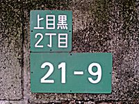
The final three elements of the address in Jukyo hyōji style are the city district (chōme 丁目), the city block
City block
A city block, urban block or simply block is a central element of urban planning and urban design. A city block is the smallest area that is surrounded by streets. City blocks are the space for buildings within the street pattern of a city, they form the basic unit of a city's urban fabric...
(ban 番) and finally the house
House
A house is a building or structure that has the ability to be occupied for dwelling by human beings or other creatures. The term house includes many kinds of different dwellings ranging from rudimentary huts of nomadic tribes to free standing individual structures...
number (gō 号). Chōme and ban numbers are usually assigned by order of proximity to the center of the municipality. Gō numbers are usually assigned by clockwise order around the ban city block. The final three elements of the address in Chiban style are the city district (chōme 丁目), the land number (banchi 番地) and finally the land number extension. The land number and land number extension designate a piece of land registered in the land registry. A land number extension is assigned when a piece of land is divided into two or more pieces in the registry. As these are all numbers, they are usually simply written as a string, 1-2-3, starting with the chōme and ending in the gō. In urban apartment buildings it is not unusual to add the apartment number as a fourth element. This three-element system is relatively new introduction, and is not completed in some areas such as older area of the cities or sparsely populated rural areas, where only the banchi is written after machi or aza.
Street name
A street name or odonym is an identifying name given to a street. The street name usually forms part of the address...
s are seldom used in postal addresses (except in Kyoto
Kyoto
is a city in the central part of the island of Honshū, Japan. It has a population close to 1.5 million. Formerly the imperial capital of Japan, it is now the capital of Kyoto Prefecture, as well as a major part of the Osaka-Kobe-Kyoto metropolitan area.-History:...
and some Hokkaidō cities such as Sapporo), and most Japanese streets do not have names. Banchi blocks often have an irregular shape, as banchi numbers were assigned by order of registration in the older system, meaning that especially in older areas of the city they will not run in a linear order. It is for this reason that when giving directions to a location, most people will offer cross streets, visual landmarks and subway
Tokyo Metro Ginza Line
The is a subway line located in Tokyo, Japan. It is part of the of Tokyo Metro network. The official name is . It is 14.3 km long and serves the wards of Shibuya, Minato, Chūō, Chiyoda, and Taitō....
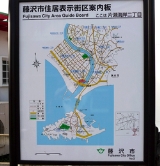
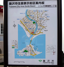
stations such as "at Chūō-dori and Matsuya-dori across the street from Matsuya and Ginza station", for a store in Tokyo. In fact, many businesses have maps on their literature and business cards. In addition, signs attached to utility poles often specify the city district name and block number, and detailed block maps of the immediate area are sometimes posted near bus stops and train station exits.
In addition to the address itself, all locations in Japan have a postal code
Postal codes in Japan
Postal codes in Japan are 7 digit numeric. Format is NNN-NNNN, where N is a number.See also: Japanese addressing system...
. After the reform of 1998, this begins with a three-digit number, a hyphen, and a four-digit number, for example 123-4567. A postal mark, 〒, may precede the code to indicate that the number following is a postal code.
Address order
In Japanese, the address is written in order from largest unit to smallest, with the addressee's name last of all. For example, the address of the Tokyo Central Post Office is- 〒100-8994
東京都中央区八重洲一丁目5番3号
東京中央郵便局
- 〒100-8994
Tōkyō-to Chūō-ku Yaesu 1-Chōme 5-ban 3-gō
Tōkyō Chūō Yūbin-kyoku'
or
- 〒100-8994
東京都中央区八重洲1-5-3
東京中央郵便局
- 〒100-8994
Tōkyō-to Chūō-ku Yaesu 1-5-3
Tōkyō Chūō Yūbin-kyoku
The order is reversed when writing in roman letters
Romanization of Japanese
The romanization of Japanese is the application of the Latin alphabet to write the Japanese language. This method of writing is known as , less strictly romaji, literally "Roman letters", sometimes incorrectly transliterated as romanji or rōmanji. There are several different romanization systems...
, to better suit Western conventions. The format recommended by Japan Post
Japan Post
was a government-owned corporation in Japan, that existed from 2003–2007, offering postal and package delivery services, banking services, and life insurance. It had over 400,000 employees and ran 24,700 post offices throughout Japan and was the nation's largest employer. One third of all Japanese...
is:
- Tokyo Central Post Office
5-3, Yaesu 1-Chome
Chuo-ku, Tokyo 100-8994
In this address, Tokyo is the prefecture; Chuo-ku
Chuo, Tokyo
is one of the 23 special wards that form the heart of Tokyo, Japan. The ward refers to itself as Chūō City in English.Its Japanese name literally means "Central Ward," and it is historically the main commercial center of Tokyo, although Shinjuku has risen to challenge it since the end of World War II...
is one of the special wards; Yaesu
Yaesu
is a neighborhood in Chūō, Tokyo, Japan, located north of Ginza, west of Nihonbashi and Kyōbashi, and adjacent to the east side of Tokyo Station. The Yaesu exit, which faces Nihonbashi, is recent and primarily provides access to the Shinkansen platforms.-History:...
1-Chome is the name of the city district; and 5-3 is the city block and building number. In practice it is common for the chōme to be prefixed, as in Japanese, resulting in the somewhat shorter
- Tokyo Central Post Office
1-5-3 Yaesu, Chuo-ku
Tokyo 100-8994
Special cases
As mentioned above, there are certain areas of Japan that use somewhat unique address systems. Sometimes the differing system has been incorporated into the official system, as in Sapporo, while in KyotoKyoto
is a city in the central part of the island of Honshū, Japan. It has a population close to 1.5 million. Formerly the imperial capital of Japan, it is now the capital of Kyoto Prefecture, as well as a major part of the Osaka-Kobe-Kyoto metropolitan area.-History:...
the system is completely different from, but used alongside the official system. Kyoto and Sapporo have addresses based on their streets being laid out in a grid plan
Grid plan
The grid plan, grid street plan or gridiron plan is a type of city plan in which streets run at right angles to each other, forming a grid...
, unlike most Japanese cities.
Kyoto
Vernacular geography
Vernacular geography is the sense of place that is revealed in ordinary people's language. Current research by the Ordnance Survey is attempting to understand the way people talk about their spatial environment and say where things are within it...
. This system is, however, recognized by the post office and by government agencies.
For added precision, the street-based address can be given, followed by the chō and land number. Sometimes multiple houses share a given land number, in which case the name (either just family name, or full name of resident) must also be specified; this name is generally displayed in front of the house on a , often decoratively presented, as house numbers are in other countries.
The system works by naming the intersection of two streets and then indicating if the address is , , , or of the intersection. More precisely, the two streets of the intersection are not treated symmetrically: one names the street that the address is on, then gives a nearby cross street, and then specifies the address relative to the cross street. What this means is that a building can have more than one address depending on which cross street intersection is chosen.
The official address to Kyoto Tower
Kyoto Tower
is an observation tower located in Kyoto, Japan. The steel tower is the tallest structure in Kyoto with its observation deck at 100 meters and its spire at 131 meters . The 800-ton tower stands atop a 9-story building, which houses a 3-star hotel and several stores...
is:
- 〒600-8216
- 京都府京都市下京区東塩小路721-1
- Higashi-Shiokōji 721-1, Shimogyō-ku, Kyōto-shi, Kyōto-fu 600-8216
However, the informal address to Kyoto Tower, is:
- 〒600-8216
- 京都府京都市下京区烏丸七条下ル
- Karasuma-Shichijō-sagaru, Shimogyō-ku, Kyōto-shi, Kyōto-fu
This address means "south of the intersection of Karasuma and Shichijō streets" – more precisely, "on Karasuma, below (south of) Shichijō" (Karasuma runs north-south, while Shichijō is an east-west cross street). The street address may alternatively be given as 烏丸通七条下ル (with inserted), indicating clearly that the address is on Karasuma street.
However, the system is flexible and allows for various alternatives, such as:
- 京都府京都市下京区烏丸塩小路上ル
- Karasuma-Shiokōji-agaru, Shimogyō-ku, Kyōto-shi, Kyōto-fu
- "(On) Karasuma (street), above (north of) Shiokōji (street)"
For less well known buildings, the official address is often given after the informal one, as in the address for the Shinatora Ramen
Ramen
is a Japanese noodle dish. It consists of Chinese-style wheat noodles served in a meat- or fish-based broth, often flavored with soy sauce or miso, and uses toppings such as , , kamaboko, green onions, and occasionally corn...
restaurant:
- 京都府京都市下京区烏丸通五条下ル大坂町384
- Ōsakachō 384, Karasuma-dōri-Gojō-sagaru, Shimogyō-ku, Kyōto-shi, Kyōto-fu
- "Ōsakachō 384, (on) Karasuma street, below (south of) Gojō"
Sapporo
Sapporo’s system, though official, differs in structure from regular Japanese addresses. The city is divided into quadrants at its centre by two intersecting roads. Blocks are then named based on their distance from this point. The east-west distance is indicated by chōme (which is a slightly different usage of chōme when compared to other cities), while the north-south distance is indicated by jō, which has been incorporated into the chō name.The address to Sapporo JR Tower
Sapporo JR Tower
Sapporo JR Tower is a skyscraper, shopping mall and office complex in Sapporo, Hokkaidō, Japan. The Tower is located above JR Sapporo Station South entrance, and the height of the tower is 173 m with 38 stories...
http://www.jr-tower.com/profile/ is:
札幌市中央区北5条西2丁目5番地
Kita-5-jō Nishi-2-chōme 5-banchi, Chūō-ku, Sapporo-shi
This address indicates that it is the fifth building on a block located 5 blocks north (kita) and 2 blocks west (nishi) of the centre.
Although the streets of Sapporo form a fairly clean grid, outside of the city centre it gets less and less practical to use the original grid starting point. In these cases an arbitrary dividing starting point is chosen from which to measure the counting of chōme and jō.
Ishikawa Prefecture
Some cities in Ishikawa PrefectureIshikawa Prefecture
is a prefecture of Japan located in the Chūbu region on Honshū island. The capital is Kanazawa.- History :Ishikawa was formed from the merger of Kaga Province and the smaller Noto Province.- Geography :Ishikawa is on the Sea of Japan coast...
, including Kanazawa
Kanazawa, Ishikawa
is the capital city of Ishikawa Prefecture, Japan.-Geography, climate, and population:Kanazawa sits on the Sea of Japan, bordered by the Japan Alps, Hakusan National Park and Noto Peninsula National Park. The city sits between the Sai and Asano rivers. Its total area is 467.77 km².Kanazawa's...
and Nanao
Nanao, Ishikawa
is a city located in Ishikawa prefecture, Japan.As of March 1, 2010, the city has an estimated population of 58,204 and a population density of 183 persons per km². Nanao is the fifth largest city by population in Ishikawa, behind Kanazawa, Hakusan, Komatsu, and Kaga.Nanao is situated in the...
, sometimes use Katakana
Katakana
is a Japanese syllabary, one component of the Japanese writing system along with hiragana, kanji, and in some cases the Latin alphabet . The word katakana means "fragmentary kana", as the katakana scripts are derived from components of more complex kanji. Each kana represents one mora...
with ordering of Iroha
Iroha
The is a Japanese poem, probably written in the Heian era . Originally the poem was attributed to the founder of the Shingon Esoteric sect of Buddhism in Japan, Kūkai, but more modern research has found the date of composition to be later in the Heian Period. The first record of its existence...
instead of numbers for blocks. These katakana are called bu (部).
For example, the address of the Kagaya Hotel http://www.kagaya.co.jp/company/gaiyo/index.html in Nanao is:
〒926-0192
石川県七尾市和倉町ヨ80
Wakuramachi yo 80, Nanao-shi, Ishikawa-ken 926-0192
History
The current addressing system was established after World War IIWorld War II
World War II, or the Second World War , was a global conflict lasting from 1939 to 1945, involving most of the world's nations—including all of the great powers—eventually forming two opposing military alliances: the Allies and the Axis...
as a slight modification of the scheme used since the Meiji era.
For historical reasons, names quite frequently conflict. In Hokkaidō many place names are identical to names found in the rest of Japan; this is largely the result of past immigration into Hokkaidō of people from mainland Japan
Mainland Japan
is a term to distinguish the area of Japan from its outlying territories. It was an official term in the pre-war period, distinguishing Japan and the colonies in East Asia...
. Historians note that there is also a significant similarity between place names in Kansai region and those in northern Kyūshū
Kyushu
is the third largest island of Japan and most southwesterly of its four main islands. Its alternate ancient names include , , and . The historical regional name is referred to Kyushu and its surrounding islands....
. See Japanese place names
Japanese place names
Japanese place names include names for geographic features, present and former administrative divisions, transportation facilities such as railroad stations, and historic sites in Japan. The article Japanese addressing system contains related information on postal addresses.-Administrative...
for more.
External links
- Japanese telephone directory (no longer available)
- Lookup Japanese addresses in English