

Jacques-Nicolas Bellin
Encyclopedia
Geographer
A geographer is a scholar whose area of study is geography, the study of Earth's natural environment and human society.Although geographers are historically known as people who make maps, map making is actually the field of study of cartography, a subset of geography...
, and member of the French intellectual group called the philosophes.
Bellin was born in Paris
Paris
Paris is the capital and largest city in France, situated on the river Seine, in northern France, at the heart of the Île-de-France region...
. He was hydrographer of France's hydrographic office
Hydrographic office
A hydrographic office is an organization which is devoted to acquiring and publishing hydrographic information.Historically, the main tasks of hydrographic offices were the conduction of hydrographic surveys and the publication of nautical charts...
, member of the Académie de Marine and of the Royal Society
Royal Society
The Royal Society of London for Improving Natural Knowledge, known simply as the Royal Society, is a learned society for science, and is possibly the oldest such society in existence. Founded in November 1660, it was granted a Royal Charter by King Charles II as the "Royal Society of London"...
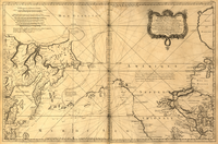
of London. Over a 50 year career, he produced a large number of maps of particular interest to the Ministère de la Marine. His maps of Canada
Canada
Canada is a North American country consisting of ten provinces and three territories. Located in the northern part of the continent, it extends from the Atlantic Ocean in the east to the Pacific Ocean in the west, and northward into the Arctic Ocean...
and of French territories in North America
North America
North America is a continent wholly within the Northern Hemisphere and almost wholly within the Western Hemisphere. It is also considered a northern subcontinent of the Americas...
(New France
New France
New France was the area colonized by France in North America during a period beginning with the exploration of the Saint Lawrence River by Jacques Cartier in 1534 and ending with the cession of New France to Spain and Great Britain in 1763...
, Acadia
Acadia
Acadia was the name given to lands in a portion of the French colonial empire of New France, in northeastern North America that included parts of eastern Quebec, the Maritime provinces, and modern-day Maine. At the end of the 16th century, France claimed territory stretching as far south as...
, Louisiana
Louisiana
Louisiana is a state located in the southern region of the United States of America. Its capital is Baton Rouge and largest city is New Orleans. Louisiana is the only state in the U.S. with political subdivisions termed parishes, which are local governments equivalent to counties...
) are particularly valuable. He died at Versailles
Versailles
Versailles , a city renowned for its château, the Palace of Versailles, was the de facto capital of the kingdom of France for over a century, from 1682 to 1789. It is now a wealthy suburb of Paris and remains an important administrative and judicial centre...
.
First Ingenieur de la Marine
In 1721, at age 18, he was appointed hydrographer (chief cartographer) to the French Navy. In August 1741, he became the first Ingénieur de la Marine of the Depot des cartes et plans de la Marine (the French Hydrographical Office) and was named Official Hydrographer of the French King.Prodigious work, high standard of excellence
During his reign the Depot came out with prodigious amount of charts and maps among which was a large folio format sea-charts of France, the Neptune Francois. He also produced a number of sea-atlases of the world, e.g., the Atlas Maritime and the Hydrographie Francaise. These gained fame, distinction and respect all over Europe and were republished throughout the 18th and even in the succeeding century.Bellin also came out with smaller format maps such as the 1764 Petit Atlas Maritime (5 vols.) containing 580 finely detailed charts.
Bellin set a very high standard of workmanship and accuracy thus gaining for France a leading role in European cartography and geography. Many of his maps were copied by other mapmakers of Europe.
Member of philosophes
He was one of the Encyclopédistes, a group of 18th century intellectuals in France who compiled the 35-volume EncyclopédieEncyclopédie
Encyclopédie, ou dictionnaire raisonné des sciences, des arts et des métiers was a general encyclopedia published in France between 1751 and 1772, with later supplements, revised editions, and translations. It was edited by Denis Diderot and Jean le Rond d'Alembert...
which was edited by Denis Diderot and Jean le Rond d'Alembert. Bellin contributed 994 articles.
The Encyclopédistes, were part of the group called philosophes among whose members were the great minds of the Age of Enlightenment
Age of Enlightenment
The Age of Enlightenment was an elite cultural movement of intellectuals in 18th century Europe that sought to mobilize the power of reason in order to reform society and advance knowledge. It promoted intellectual interchange and opposed intolerance and abuses in church and state...
, e.g., Montesquieu, Voltaire
Voltaire
François-Marie Arouet , better known by the pen name Voltaire , was a French Enlightenment writer, historian and philosopher famous for his wit and for his advocacy of civil liberties, including freedom of religion, free trade and separation of church and state...
, Rousseau, Baron d'Holbach
Baron d'Holbach
Paul-Henri Thiry, Baron d'Holbach was a French-German author, philosopher, encyclopedist and a prominent figure in the French Enlightenment. He was born Paul Heinrich Dietrich in Edesheim, near Landau in the Rhenish Palatinate, but lived and worked mainly in Paris, where he kept a salon...
. The group promoted the advancement of science and secular thought, and supported the Enlightenment's ideas on tolerance, rationality, and open-mindedness. Their overarching concern was the concept of progress, the betterment of society and human beings.
Innocent party to a geographical error
Bellin contributed a number of maps to 15-vol. Histoire Generale des Voyages of Antoine François PrévostAntoine François Prévost
Antoine François Prévost , usually known simply as the Abbé Prévost, was a French author and novelist.- Life and works :...
or simply known l'Abbe Prevost. One of these maps led to a geographical blunder whose impact reverberates to this day. This was the map of the Philippines which Bellin copied from a world-famous chart produced in 1734 by the Spanish missionary to the Philippines, Fr. Pedro Murillo Velarde.
Unlike many other European mapmakers of the time who outright appropriated Murillo's map, Bellin had the intellectual integrity to fully credit Murillo as his source, an open acknowledgement shown in the title cartouche
Cartouche (design)
A cartouche is an oval or oblong design with a slightly convex surface, typically edged with ornamental scrollwork. It is used to hold a painted or low relief design....
of Bellin's map which came out the same year as the original work by Murillo.
Shown in Bellin's map was an island named "Limasava", a word invented in 1667 by Spanish friar, Fr. Francisco Combés, S.J., to refer to the way station of the Armada de Molucca
Armada de Molucca
The Armada de Molucca was the name of the fleet led by Ferdinand Magellan in an attempt to find the Spice Islands. It consisted of five ships, Magellan's flagship Trindidad, the provision ship San Antonio, and the smaller ships Concepcion, Victoria, and Santiago.An excellent reference is: "Over...
under the command of the Portuguese captain-general Fernao de Magalhaes during its navigation in Philippine waters. Combés, who had not read a single eyewitness account of the Magellan
Ferdinand Magellan
Ferdinand Magellan was a Portuguese explorer. He was born in Sabrosa, in northern Portugal, and served King Charles I of Spain in search of a westward route to the "Spice Islands" ....
expedition relied on two sources, the hopelessly garbled Italian translation of the Antonio Pigafetta account by Giovanni Battista Ramusio
Giovanni Battista Ramusio
Giovanni Battista Ramusio was an Italian geographer and travel writer.Born in Treviso, Italy, Ramusio was the son of Paolo Ramusio, a magistrate in the city-state of Venice...
and the secondhand account by Antonio de Herrera y Tordesillas
Antonio de Herrera y Tordesillas
Antonio de Herrera y Tordesillas , Spanish historian, was born at Cuéllar, in the province of Segovia.-Biography:His father, Roderigo de Tordesillas, and his mother, Agnes de Herrera, were both of good family...
. Ramusio wrote the fleet anchored in March-April 1521 in Butuan in Mindanao, and from there sailed for Cebu with a brief stopover at "Messana". In the authentic Pigafetta account, the port was an isle named Mazzaua while the stopover isle was named Gatighan
Gatighan
The isle of Gatighan was a way station of the Armada de Molucca under Captain-General Ferdinand Magellan on their way to Cebu in Central Philippines...
. Antonio de Herrera y Tordesillas
Antonio de Herrera y Tordesillas
Antonio de Herrera y Tordesillas , Spanish historian, was born at Cuéllar, in the province of Segovia.-Biography:His father, Roderigo de Tordesillas, and his mother, Agnes de Herrera, were both of good family...
gave a faithful narration of the Mazzaua anchorage.
Combés disregarded de Herrera's version and adopted Ramusio's. He wrote that Magellan's fleet had anchored at Butuan and from their sailed for Cebu making a stop at a way station he named Limasaua.
Five years earlier than Combés, Fr. Francisco Colín wrote the Armada moored at Butuan from March-April 1521 where Magellan and his men together with the natives celebrated an Easter Sunday mass on March 31, 1521. From Butuan the fleet sailed for Cebu making a brief stop at a way station he called "Dimasaua
Dimasaua
Dimasaua, also spelled Dimasawa and Dimasava, was the invented name created by 17th century Spanish missionary Fr. Francisco Colín, S.J., pointing to a tiny isle in southern Leyte whose chief, according to Colín, "gave the most signal service" to Ferdinand Magellan and his crew at the port of...
", an invented word meaning "this is not the Mazagua of Antonio de Herrera where supposedly an Easter Sunday mass was held which I already said happened in Butuan."
This episode was projected in the 1734 map made by Murillo who used Combés name, "Limassava" not "Dimasaua" which map Bellin copied.
Gatighan becomes Limasava
In 1789, Augustinian Carlo AmorettiCarlo Amoretti
Carlo Amoretti was an ecclesiastic, scholar, writer, and scientist. He was born in Oneglia, now Imperia in the Liguria region, Italy.He entered the Augustinian order in 1757...
, Italian Encyclopedist and librarian of Biblioteca Ambrosiana
Biblioteca Ambrosiana
The Biblioteca Ambrosiana is a historic library in Milan, Italy, also housing the Pinacoteca Ambrosiana, the Ambrosian art gallery. Named after Ambrose, the patron saint of Milan, it was founded by Cardinal Federico Borromeo , whose agents scoured Western Europe and even Greece and Syria for books...
in Milan
Milan
Milan is the second-largest city in Italy and the capital city of the region of Lombardy and of the province of Milan. The city proper has a population of about 1.3 million, while its urban area, roughly coinciding with its administrative province and the bordering Province of Monza and Brianza ,...
, discovered the authentic Italian manuscript of Antonio Pigafetta
Antonio Pigafetta
Antonio Pigafetta was an Italian scholar and explorer from the Republic of Venice. He travelled with the Portuguese explorer Ferdinand Magellan and his crew on their voyage to the Indies. During the expedition, he served as Magellan's assistant and kept an accurate journal which later assisted him...
among the scattered holdings of the library. Here it came out that the port of March-April 1521 was not Butuan but Mazaua. Amoretti, who himself had not read any of five eyewitness reports of the incident including two French versions of Pigafetta's account, asserted in a footnote that Mazaua was probably the isle named Limasava in Bellin's map, thus interchanging the real port of Mazaua with the way station Gatighan
Gatighan
The isle of Gatighan was a way station of the Armada de Molucca under Captain-General Ferdinand Magellan on their way to Cebu in Central Philippines...
.
Largely with the appearance of the eyewitness account of Ginés de Mafra
Gines de Mafra
Ginés de Mafra was a Spanish explorer who sailed to the Philippines in the 16th century. De Mafra was a member of the expeditions of Ferdinand Magellan of 1519–1521 and Ruy López de Villalobos of 1542–1545.- Voyage to the Philippine Islands:...
, the only seaman in Magellan's fleet to return to Mazaua, whose testimony reveals a concrete, measurable description of Mazaua, the skein starting from the garbled version of Pigafetta
Pigafetta
Pigafetta is a genus of two palm species in the family Arecaceae. They are native to the Maluku Islands, Sulawesi, and Western New Guinea where they grow near rivers and in forest clearings up to 900 m in elevation. It is named for Antonio Pigafetta and is sometimes misspelled as Pigafettia...
by Ramusio
Ramusio
The noble Italian family of Ramusio was worth of note for literary and official ability during at least four generations....
to the mishandling by Combés to Bellin and finally to Amoretti has been unraveled: Pigafetta's Gatighan
Gatighan
The isle of Gatighan was a way station of the Armada de Molucca under Captain-General Ferdinand Magellan on their way to Cebu in Central Philippines...
is Bellin's Limasava.
Published works
Published during his lifetime were:- Hydrographie française (1753)
- Carte de l'Amérique septentrionale (Map of Northern AmericaNorthern AmericaNorthern America is the northernmost region of the Americas, and is part of the North American continent. It lies directly north of the region of Middle America; the land border between the two regions coincides with the border between the United States and Mexico...
) (1755) - Petit Atlas Maritime (1764)
- Nouvelle méthode pour apprendre la géographie (1769)
External links
- See a 1754 map by Jacque-Nicolas Bellin, Karte von der Erdenge Panama und den Provinzen Veragua, Terra Firma und Darien / zur allgemeinen Historie der Reisen, von dem Hrn Bellin ; Ing. de la Marine., hosted by the Portal to Texas History.