

Jacques-Cartier River
Encyclopedia
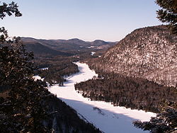
The Jacques-Cartier River is a river in the province of Quebec, Canada. It is 161 km long and its source is Jacques-Cartier Lake in Laurentides Wildlife Reserve, and flows in a predominantly southern direction before ending in the Saint Lawrence River
at Donnacona
, about 30 km upstream from Quebec City
.
It is currently under nomination for Canadian Heritage River
status.
in the geological region of Grenville (one of the youngest sections of the Canadian Shield
, formed 955 million years ago), then flows through the sedimentary rocks of the St. Lawrence lowlands for approximately 17 kilometers, from the municipality of Pont-Rouge to its mouth.
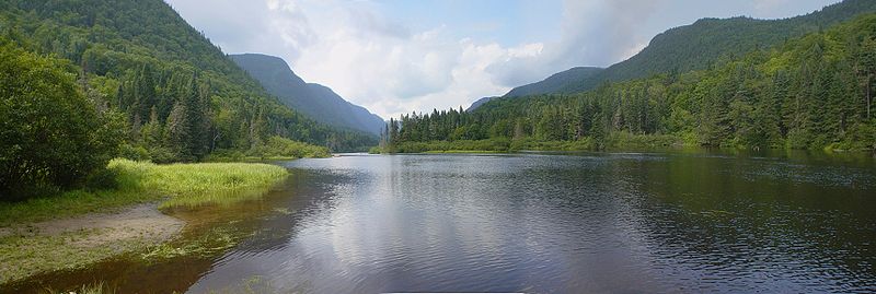
The area covered by the drainage basin is for the most part undeveloped or protected, especially its source. In fact, 77% of its length is protected by the Laurentides Wildlife Reserve and the Jacques-Cartier National Park
where one finds a steep glaciated valley formed during the last glaciation. Nevertheless, about 25000 people live on the shores of this river close to its mouth, where it crosses the regional municipality of Portneuf
and the municipalities of Tewkesbury, Saint-Gabriel-de-Valcartier, Shannon, Sainte-Catherine-de-la-Jacques-Cartier, Pont-Rouge and Donnacona.
Important tributaries are:
 The reports that according to surveyor John Adams, in 1829, the river was known by the Hurons as Lahdaweoole, meaning “coming from far”. They and the Montagnais used its shores for fishing and trapping. It is estimated that this region has been used by First Nations for over 7000 years. Explorer Samuel de Champlain
mentioned this river in 1632 as the "Sturgeon and Salmon River". In 1656, a map of Samson of Abbeville showed "R. J. Quartier" as the river's designation, probably so named according to the popular belief that Jacques Cartier
had passed by the river's mouth. This natural highway was used among others by Jesuit missionaries
to reach the Lac Saint-Jean
area during the 17th century.
Logging
in the Laurentian highlands became an important economic activity during the second half of the 18th century. The Jacques-Cartier River was used for log drives
to transport the logs to the Saint-Lawrence River and to the mills downstream. This practice was only stopped in 1975. With the settlement of French immigrants near the river's mouth came the formation of townships (modelled after English townships after their conquest of 1759
) and new industries appeared such as flour mills.
In 1895 the Laurentian Wildlife Reserve was created to provide fishing, hunting, and recreation opportunities for the people. From 1918 on, the construction of fishing camps made fishing more and more popular. The end of the First World War and the construction of nearby roads to Lac Saint-Jean also contributed to this popularity. Then hydro-electric dams started to be built, taking advantage of the river's geography up until the 1970s. In 1972, a proposed Hydro-Québec
project would have flooded the Jacques-Cartier River valley, but the project was strongly opposed by the population. The government reversed its decision and in 1981 Jacques-Cartier Park was created out of the wildlife reserve as a 671 km² conservation park, accessible to the public for nature interpretation and nature friendly recreation activities.
and Sugar maple
, whereas the surrounding areas show rather the boreal forest rich in conifers, in particular the black spruce
. This distinction is clearly visible in the steeper sections of the valley where a milder microclimate prevails.
The fauna therefore is typical of a Canadian mixed forest. One can find in the Jacques-Cartier River valley the American Black Bear
, Bobcat
, Common Raccoon, Gray Wolf
, River Otter
, Porcupine
, Moose
, White-tailed Deer
, and Caribou; in all 23 species of mammal
s. There are 104 species of birds, including birds of prey such as Barred Owl
, American Kestrel
, and Osprey
. Finally, there are 16 species of fish, of which Brook trout
in particular can be found frequently. In addition, a reintroduction program has been established for Atlantic salmon
, which disappeared from the river in the 19th century.
Saint Lawrence River
The Saint Lawrence is a large river flowing approximately from southwest to northeast in the middle latitudes of North America, connecting the Great Lakes with the Atlantic Ocean. It is the primary drainage conveyor of the Great Lakes Basin...
at Donnacona
Donnacona, Quebec
Donnacona is an industrial town located about west of Quebec City in Portneuf County, Quebec, Canada.Some people believe the city was named after Donnacona, a 16th century Wendat chief who was taken to France...
, about 30 km upstream from Quebec City
Quebec City
Quebec , also Québec, Quebec City or Québec City is the capital of the Canadian province of Quebec and is located within the Capitale-Nationale region. It is the second most populous city in Quebec after Montreal, which is about to the southwest...
.
It is currently under nomination for Canadian Heritage River
Canadian Heritage Rivers System
The Canadian Heritage Rivers System was established in 1984 by the federal, provincial and territorial governments to conserve and protect the best examples of Canada's river heritage, to give them national recognition, and to encourage the public to enjoy and appreciate them. It is a cooperative...
status.
Geography
The Jacques-Cartier River drains an area of 2515 square kilometres, starting in and flowing for nearly 160 kilometers through the Laurentian mountainsLaurentian mountains
The Laurentian Mountains are a mountain range in southern Quebec, Canada, north of the St. Lawrence River and Ottawa River, rising to a highest point of 1166 metres at Mont Raoul Blanchard, north east of Quebec City in the Reserve Faunique des Laurentides. The Gatineau, L'Assomption, Lièvre,...
in the geological region of Grenville (one of the youngest sections of the Canadian Shield
Canadian Shield
The Canadian Shield, also called the Laurentian Plateau, or Bouclier Canadien , is a vast geological shield covered by a thin layer of soil that forms the nucleus of the North American or Laurentia craton. It is an area mostly composed of igneous rock which relates to its long volcanic history...
, formed 955 million years ago), then flows through the sedimentary rocks of the St. Lawrence lowlands for approximately 17 kilometers, from the municipality of Pont-Rouge to its mouth.
The area covered by the drainage basin is for the most part undeveloped or protected, especially its source. In fact, 77% of its length is protected by the Laurentides Wildlife Reserve and the Jacques-Cartier National Park
Jacques-Cartier National Park
Jacques-Cartier National Park is a provincial park located 50 km north of Quebec City. The park has the mission of protecting a representative territory of the Laurentian massif.It is quite close to Canadian Forces Military Base Valcartier...
where one finds a steep glaciated valley formed during the last glaciation. Nevertheless, about 25000 people live on the shores of this river close to its mouth, where it crosses the regional municipality of Portneuf
Portneuf Regional County Municipality, Quebec
Portneuf is a Regional County Municipality in the Canadian province of Quebec. The county administrative seat is Cap-Santé.- History :The Regional County Municipality of Portneuf was constituted as a regional administrative entity on November 25th 1981 by a Provincial decree creating the supralocal...
and the municipalities of Tewkesbury, Saint-Gabriel-de-Valcartier, Shannon, Sainte-Catherine-de-la-Jacques-Cartier, Pont-Rouge and Donnacona.
Important tributaries are:
- Rivière aux Pommes (Apple River)
- Rivière Sautauriski
- Rivière Ontaritzi
- Rivière à l'Épaule (Shoulder River)
- Rivière Cachée (Hidden River)
- Rivière Launière.
History
Samuel de Champlain
Samuel de Champlain , "The Father of New France", was a French navigator, cartographer, draughtsman, soldier, explorer, geographer, ethnologist, diplomat, and chronicler. He founded New France and Quebec City on July 3, 1608....
mentioned this river in 1632 as the "Sturgeon and Salmon River". In 1656, a map of Samson of Abbeville showed "R. J. Quartier" as the river's designation, probably so named according to the popular belief that Jacques Cartier
Jacques Cartier
Jacques Cartier was a French explorer of Breton origin who claimed what is now Canada for France. He was the first European to describe and map the Gulf of Saint Lawrence and the shores of the Saint Lawrence River, which he named "The Country of Canadas", after the Iroquois names for the two big...
had passed by the river's mouth. This natural highway was used among others by Jesuit missionaries
Missionary
A missionary is a member of a religious group sent into an area to do evangelism or ministries of service, such as education, literacy, social justice, health care and economic development. The word "mission" originates from 1598 when the Jesuits sent members abroad, derived from the Latin...
to reach the Lac Saint-Jean
Lac Saint-Jean
Lac Saint-Jean is a large, relatively shallow lake in south-central Quebec, Canada, in the Laurentian Highlands. It is situated 206 kilometres north of the Saint Lawrence River, into which it drains via the Saguenay River. It covers an area of 1003 km² Lac Saint-Jean is a large, relatively...
area during the 17th century.
Logging
Logging
Logging is the cutting, skidding, on-site processing, and loading of trees or logs onto trucks.In forestry, the term logging is sometimes used in a narrow sense concerning the logistics of moving wood from the stump to somewhere outside the forest, usually a sawmill or a lumber yard...
in the Laurentian highlands became an important economic activity during the second half of the 18th century. The Jacques-Cartier River was used for log drives
Log driving
Log driving is a means of log transport which makes use of a river's current to move floating tree trunks downstream to sawmills and pulp mills.It was the main transportation method of the early logging industry in Europe and North America...
to transport the logs to the Saint-Lawrence River and to the mills downstream. This practice was only stopped in 1975. With the settlement of French immigrants near the river's mouth came the formation of townships (modelled after English townships after their conquest of 1759
Battle of the Plains of Abraham
The Battle of the Plains of Abraham, also known as the Battle of Quebec, was a pivotal battle in the Seven Years' War...
) and new industries appeared such as flour mills.
In 1895 the Laurentian Wildlife Reserve was created to provide fishing, hunting, and recreation opportunities for the people. From 1918 on, the construction of fishing camps made fishing more and more popular. The end of the First World War and the construction of nearby roads to Lac Saint-Jean also contributed to this popularity. Then hydro-electric dams started to be built, taking advantage of the river's geography up until the 1970s. In 1972, a proposed Hydro-Québec
Hydro-Québec
Hydro-Québec is a government-owned public utility established in 1944 by the Government of Quebec. Based in Montreal, the company is in charge of the generation, transmission and distribution of electricity across Quebec....
project would have flooded the Jacques-Cartier River valley, but the project was strongly opposed by the population. The government reversed its decision and in 1981 Jacques-Cartier Park was created out of the wildlife reserve as a 671 km² conservation park, accessible to the public for nature interpretation and nature friendly recreation activities.
Flora and fauna
The river bank is typically mixed forest, consisting of Yellow birchYellow Birch
Betula alleghaniensis , is a species of birch native to eastern North America, from Newfoundland to Nova Scotia, New Brunswick, southern Quebec and Ontario, and the southeast corner of Manitoba in Canada, west to Minnesota, and south in the Appalachian Mountains to northern Georgia.It is a...
and Sugar maple
Sugar Maple
Acer saccharum is a species of maple native to the hardwood forests of northeastern North America, from Nova Scotia west to southern Ontario, and south to Georgia and Texas...
, whereas the surrounding areas show rather the boreal forest rich in conifers, in particular the black spruce
Black Spruce
Picea mariana is a species of spruce native to northern North America, from Newfoundland west to Alaska, and south to northern New York, Minnesota and central British Columbia...
. This distinction is clearly visible in the steeper sections of the valley where a milder microclimate prevails.
The fauna therefore is typical of a Canadian mixed forest. One can find in the Jacques-Cartier River valley the American Black Bear
American black bear
The American black bear is a medium-sized bear native to North America. It is the continent's smallest and most common bear species. Black bears are omnivores, with their diets varying greatly depending on season and location. They typically live in largely forested areas, but do leave forests in...
, Bobcat
Bobcat
The bobcat is a North American mammal of the cat family Felidae, appearing during the Irvingtonian stage of around 1.8 million years ago . With twelve recognized subspecies, it ranges from southern Canada to northern Mexico, including most of the continental United States...
, Common Raccoon, Gray Wolf
Gray Wolf
The gray wolf , also known as the wolf, is the largest extant wild member of the Canidae family...
, River Otter
Northern River Otter
The North American river otter , also known as the northern river otter or the common otter, is a semiaquatic mammal endemic to the North American continent, found in and along its waterways and coasts. An adult river otter can weigh between 5 and 14 kg...
, Porcupine
North American Porcupine
The North American Porcupine , also known as Canadian Porcupine or Common Porcupine, is a large rodent in the New World porcupine family. The Beaver is the only rodent larger than the North American Porcupine found in North America...
, Moose
Moose
The moose or Eurasian elk is the largest extant species in the deer family. Moose are distinguished by the palmate antlers of the males; other members of the family have antlers with a dendritic configuration...
, White-tailed Deer
White-tailed Deer
The white-tailed deer , also known as the Virginia deer or simply as the whitetail, is a medium-sized deer native to the United States , Canada, Mexico, Central America, and South America as far south as Peru...
, and Caribou; in all 23 species of mammal
Mammal
Mammals are members of a class of air-breathing vertebrate animals characterised by the possession of endothermy, hair, three middle ear bones, and mammary glands functional in mothers with young...
s. There are 104 species of birds, including birds of prey such as Barred Owl
Barred Owl
The Barred Owl is a large typical owl. It goes by many other names, including eight hooter, rain owl, wood owl, and striped owl, but is probably best known as the hoot owl.-Description:...
, American Kestrel
American Kestrel
The American Kestrel , sometimes colloquially known as the Sparrow Hawk, is a small falcon, and the only kestrel found in the Americas. It is the most common falcon in North America, and is found in a wide variety of habitats. At long, it is also the smallest falcon in North America...
, and Osprey
Osprey
The Osprey , sometimes known as the sea hawk or fish eagle, is a diurnal, fish-eating bird of prey. It is a large raptor, reaching more than in length and across the wings...
. Finally, there are 16 species of fish, of which Brook trout
Brook trout
The brook trout, Salvelinus fontinalis, is a species of fish in the salmon family of order Salmoniformes. In many parts of its range, it is known as the speckled trout or squaretail. A potamodromous population in Lake Superior are known as coaster trout or, simply, as coasters...
in particular can be found frequently. In addition, a reintroduction program has been established for Atlantic salmon
Atlantic salmon
The Atlantic salmon is a species of fish in the family Salmonidae, which is found in the northern Atlantic Ocean and in rivers that flow into the north Atlantic and the north Pacific....
, which disappeared from the river in the 19th century.