
Jack's Creek Covered Bridge
Encyclopedia
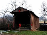
The Jack's Creek Covered Bridge, also known as the Upper Covered Bridge, is a county owned wooden covered bridge
that spans the Smith River
in Patrick County, Virginia
, United States
. It is located on Jack's Creek Road (SR 615) off State Route 8
just south of the community of Woolwine
, about 11 miles (18 kilometers) north of Stuart
. Coordinates are 36°45′51.14"N 80°16′23.98"W (36.764206, -80.273328).
Built in 1914 (some sources say 1916), the 48-foot (15-meter) bridge is a Queen-post truss construction over a single span. Its WGCB
number is 46-68-02. The Jack's Creek Covered Bridge was listed on the National Register of Historic Places
on May 22, 1973. It is one of two historic covered bridges remaining in Patrick County, maintained by the Patrick County government.
) of the Patrick County Covered Bridge Festival.
Covered bridge
A covered bridge is a bridge with enclosed sides and a roof, often accommodating only a single lane of traffic. Most covered bridges are wooden; some newer ones are concrete or metal with glass sides...
that spans the Smith River
Smith River (Virginia)
The Smith River is a river in the U.S. states of Virginia and North Carolina. It is a tributary of the Dan River, which it joins at Eden, North Carolina...
in Patrick County, Virginia
Patrick County, Virginia
Patrick County is a county located in the Commonwealth of Virginia. As of 2010, the population was 18,490. Its county seat is Stuart. It is located within both the rolling hills and valleys of the Piedmont Region of Virginia and mountainous Southwest Virginia....
, United States
United States
The United States of America is a federal constitutional republic comprising fifty states and a federal district...
. It is located on Jack's Creek Road (SR 615) off State Route 8
Virginia State Route 8
Virginia State Route 8 is a primary state highway in the U.S. state of Virginia. The state highway runs from the North Carolina state line near Palmetto, where the highway continues south as North Carolina Highway 8 , north to U.S. Route 11 in Christiansburg...
just south of the community of Woolwine
Woolwine, Virginia
Woolwine is an unincorporated community in northern Patrick County, Virginia, United States. The western terminus of State Route 40 is here, at State Route 8. The community lies in the Rocky Knob American Viticultural Area...
, about 11 miles (18 kilometers) north of Stuart
Stuart, Virginia
Stuart is a town in Patrick County, Virginia, United States, and its county seat. The population was 961 at the 2000 census. Due to recent boundary expansion, the town of Stuart has an estimated population of nearly 1,700 residents. The town of Stuart was named after Confederate Gen. J.E.B...
. Coordinates are 36°45′51.14"N 80°16′23.98"W (36.764206, -80.273328).
Built in 1914 (some sources say 1916), the 48-foot (15-meter) bridge is a Queen-post truss construction over a single span. Its WGCB
World Guide to Covered Bridges
The World Guide to Covered Bridges is a covered bridge numbering system. The system was invented by John Diehl, the chairman of the Ohio Covered Bridge Committee. The committee first used the numbering system in 1953 to publish a list of covered bridges in Ohio....
number is 46-68-02. The Jack's Creek Covered Bridge was listed on the National Register of Historic Places
National Register of Historic Places
The National Register of Historic Places is the United States government's official list of districts, sites, buildings, structures, and objects deemed worthy of preservation...
on May 22, 1973. It is one of two historic covered bridges remaining in Patrick County, maintained by the Patrick County government.
History
The Jack's Creek Covered Bridge was designed by Walter G. Weaver of Woolwine and constructed by Charles Vaughan of Buffalo Ridge, made of oak, built to serve Jack's Creek Primitive Baptist Church for which the bridge was named after. A steel beam bridge replaced it in 1932. The Jack's Creek Covered Bridge was widened and received a new roof in 1969 followed by a full restoration by the Virginia Department of Highways in 1974 at a cost of approximately $4,550.00. Every June, the bridge is the site (along with nearby Bob White Covered BridgeBob White Covered Bridge
The Bob White Covered Bridge, also known as the Lower Covered Bridge or Woolwine Covered Bridge, is a county owned wooden covered bridge that spans the Smith River in Patrick County, Virginia, United States. It is located on the old portion of Bob White Road off State Route 8 southeast of the...
) of the Patrick County Covered Bridge Festival.