

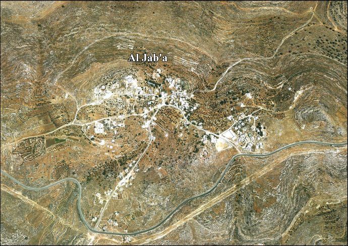
Jab'a
Encyclopedia
Jab'a is a Palestinian
village in the central West Bank
, located 17 kilometers north of Hebron and 15 kilometers southwest of Bethlehem
. Located three kilometers east of the Green Line
, it is located in the Seam Zone
, surrounded by the Israeli settlement
s in the Gush Etzion Regional Council
and the Israeli West Bank barrier
. Nearby Palestinian towns and villages include Surif
adjacent to the Jaba'a, Wadi Fukin
and Nahalin to the north. It is the northernmost locality in the Hebron Governorate
. According to the Palestinian Central Bureau of Statistics
, Jab'a had a population of approximately 896 in 2007. Jab'a has a total land area of 10,099 dunam
s, of which 1,002 dunams as built up area.
Jab'a dates back to the Canaan
ites. The village houses are small and consist of just one spacious room surrounded by a large area of farmland, on which almonds and olives grapes and are cultivated.
In 1596, Jaba appeared in Ottoman tax registers as being in the Nahiya of Quds of the Liwa
of Quds. It had a population of 3 Muslim households and paid taxes on wheat, barley, olives, and goats or beehives.
Palestinian people
The Palestinian people, also referred to as Palestinians or Palestinian Arabs , are an Arabic-speaking people with origins in Palestine. Despite various wars and exoduses, roughly one third of the world's Palestinian population continues to reside in the area encompassing the West Bank, the Gaza...
village in the central West Bank
West Bank
The West Bank ) of the Jordan River is the landlocked geographical eastern part of the Palestinian territories located in Western Asia. To the west, north, and south, the West Bank shares borders with the state of Israel. To the east, across the Jordan River, lies the Hashemite Kingdom of Jordan...
, located 17 kilometers north of Hebron and 15 kilometers southwest of Bethlehem
Bethlehem
Bethlehem is a Palestinian city in the central West Bank of the Jordan River, near Israel and approximately south of Jerusalem, with a population of about 30,000 people. It is the capital of the Bethlehem Governorate of the Palestinian National Authority and a hub of Palestinian culture and tourism...
. Located three kilometers east of the Green Line
Green Line (Israel)
Green Line refers to the demarcation lines set out in the 1949 Armistice Agreements between Israel and its neighbours after the 1948 Arab-Israeli War...
, it is located in the Seam Zone
Seam Zone
Seam Zone is a term used to refer to a land area in the West Bank located east of the Green Line and west of Israel's separation barrier, populated largely by Israelis in settlements such as Alfei Menashe, Ariel, Beit Arye, Modi'in Illit, Giv'at Ze'ev, Ma'ale Adumim, Beitar Illit and Efrat.As of...
, surrounded by the Israeli settlement
Israeli settlement
An Israeli settlement is a Jewish civilian community built on land that was captured by Israel from Jordan, Egypt, and Syria during the 1967 Six-Day War and is considered occupied territory by the international community. Such settlements currently exist in the West Bank...
s in the Gush Etzion Regional Council
Gush Etzion Regional Council
The Gush Etzion Regional Council is a regional council in the northern Judean Hills, the northern part of the southern area of the West Bank, administering the settlements in the Gush Etzion region, as well as others nearby...
and the Israeli West Bank barrier
Israeli West Bank barrier
The Israeli West Bank barrier is a separation barrier being constructed by the State of Israel along and within the West Bank. Upon completion, the barrier’s total length will be approximately...
. Nearby Palestinian towns and villages include Surif
Surif
Surif is a Palestinian town in the Hebron Governorate located 25 km northwest of the city of Hebron. According to the Palestinian Central Bureau of Statistics census, Surif had a population of 13,365 in 2007. The population is entirely Muslim....
adjacent to the Jaba'a, Wadi Fukin
Wadi Fukin
Wadi Fukin is a Palestinian village in the West Bank, eight kilometers southwest of Bethlehem in the Bethlehem Governorate. The village is located between the Green Line and the Israeli West Bank barrier. According to the Palestinian Central Bureau of Statistics, Wadi Fukin had a population of...
and Nahalin to the north. It is the northernmost locality in the Hebron Governorate
Hebron Governorate
The Hebron Governorate is an administrative district of the Palestinian National Authority in the southern West Bank. It extends south to, and includes most of, the Dead Sea....
. According to the Palestinian Central Bureau of Statistics
Palestinian Central Bureau of Statistics
The Palestinian Central Bureau of Statistics is the statistical organization under the umbrella of the Palestinian Cabinet of the Palestinian National Authority....
, Jab'a had a population of approximately 896 in 2007. Jab'a has a total land area of 10,099 dunam
Dunam
A dunam or dönüm, dunum, donum, dynym, dulum was a non-SI unit of land area used in the Ottoman Empire and representing the amount of land that can be plowed in a day; its value varied from 900–2500 m²...
s, of which 1,002 dunams as built up area.
Jab'a dates back to the Canaan
Canaan
Canaan is a historical region roughly corresponding to modern-day Israel, Palestine, Lebanon, and the western parts of Jordan...
ites. The village houses are small and consist of just one spacious room surrounded by a large area of farmland, on which almonds and olives grapes and are cultivated.
In 1596, Jaba appeared in Ottoman tax registers as being in the Nahiya of Quds of the Liwa
Liwa (arabic)
Liwa or Liwa is an Arabic term meaning district, banner, or flag, a type of administrative division. It was interchangeable with the Turkish term "Sanjak" in the time of the Ottoman Empire. After the fall of the empire, the term was used in the Arab countries formerly under Ottoman rule...
of Quds. It had a population of 3 Muslim households and paid taxes on wheat, barley, olives, and goats or beehives.