
Izu-Bonin-Mariana Arc
Encyclopedia
Convergent boundary
In plate tectonics, a convergent boundary, also known as a destructive plate boundary , is an actively deforming region where two tectonic plates or fragments of lithosphere move toward one another and collide...
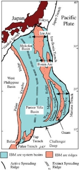
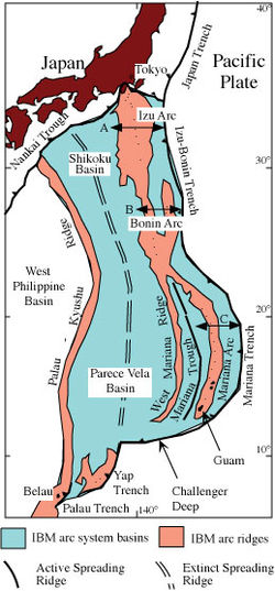
. IBM extends over 2800 km south from Tokyo, Japan
Japan
Japan is an island nation in East Asia. Located in the Pacific Ocean, it lies to the east of the Sea of Japan, China, North Korea, South Korea and Russia, stretching from the Sea of Okhotsk in the north to the East China Sea and Taiwan in the south...
, to beyond Guam
Guam
Guam is an organized, unincorporated territory of the United States located in the western Pacific Ocean. It is one of five U.S. territories with an established civilian government. Guam is listed as one of 16 Non-Self-Governing Territories by the Special Committee on Decolonization of the United...
, and includes the Izu Islands
Izu Islands
The are a group of volcanic islands stretching south and east from the Izu Peninsula of Honshū, Japan. Administratively, they form two towns and six villages; all part of Tokyo. The largest is Izu Ōshima, usually called simply Ōshima....
, Bonin Islands, and Mariana Islands
Mariana Islands
The Mariana Islands are an arc-shaped archipelago made up by the summits of 15 volcanic mountains in the north-western Pacific Ocean between the 12th and 21st parallels north and along the 145th meridian east...
; much more of the IBM arc system is submerged below sealevel. The IBM arc system lies along the eastern margin of the Philippine Sea Plate in the Western Pacific Ocean. It is most famous for being the site of the deepest gash in Earth's solid surface, the Challenger Deep
Challenger Deep
The Challenger Deep is the deepest known point in the oceans, with a depth of to by direct measurement from submersibles, and slightly more by sonar bathymetry . It is located at the southern end of the Mariana Trench near the Mariana Islands group...
in the Mariana Trench
Mariana Trench
The Mariana Trench or Marianas Trench is the deepest part of the world's oceans. It is located in the western Pacific Ocean, to the east of the Mariana Islands. The trench is about long but has a mean width of only...
.
The IBM arc system formed as a result of subduction
Subduction
In geology, subduction is the process that takes place at convergent boundaries by which one tectonic plate moves under another tectonic plate, sinking into the Earth's mantle, as the plates converge. These 3D regions of mantle downwellings are known as "Subduction Zones"...
of the western Pacific plate
Pacific Plate
The Pacific Plate is an oceanic tectonic plate that lies beneath the Pacific Ocean. At 103 million square kilometres, it is the largest tectonic plate....
. The IBM arc system now subducts mid-Jurassic to Early Cretaceous lithosphere, with younger lithosphere in the north and older lithosphere in the south, including the oldest (~170 million years old, or Ma) oceanic crust
Oceanic crust
Oceanic crust is the part of Earth's lithosphere that surfaces in the ocean basins. Oceanic crust is primarily composed of mafic rocks, or sima, which is rich in iron and magnesium...
. Subduction rates vary from ~2 cm (1 inch) per year in the south to 6 cm (~2.5 inches) in the north.
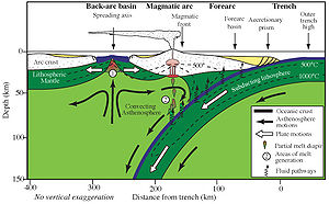
The volcanic islands that comprise these island arcs are thought to have been formed from the release of volatiles (steam from trapped water, and other gases) being released from the subducted plate, as it reached sufficient depth for the temperature to cause release of these materials. The associated trenches are formed as the oldest (most western) part of the Pacific plate crust increases in density with age, and because of this process finally reaches its lowest point just as it subducts under the crust to the west of it.
The IBM arc system is an excellent example of an intra-oceanic convergent margin (IOCM). IOCMs are built on oceanic crust
Oceanic crust
Oceanic crust is the part of Earth's lithosphere that surfaces in the ocean basins. Oceanic crust is primarily composed of mafic rocks, or sima, which is rich in iron and magnesium...
and contrast fundamentally with island arc
Volcanic arc
A volcanic arc is a chain of volcanoes positioned in an arc shape as seen from above. Offshore volcanoes form islands, resulting in a volcanic island arc. Generally they result from the subduction of an oceanic tectonic plate under another tectonic plate, and often parallel an oceanic trench...
built on continental crust, such as Japan or the Andes
Andes
The Andes is the world's longest continental mountain range. It is a continual range of highlands along the western coast of South America. This range is about long, about to wide , and of an average height of about .Along its length, the Andes is split into several ranges, which are separated...
. Because IOCM crust is thinner, denser, and more refractory than that beneath Andean-type margins, study of IOCM melts and fluids allows more confident assessment of mantle-to-crust fluxes and processes than is possible for Andean-type convergent margins. Because IOCMs are far removed from continents they are not affected by the large volume of alluvial and glacial sediments. The consequent thin sedimentary cover makes it much easier to study arc infrastructure and determine the mass and composition of subducted sediments. Active hydrothermal systems
Hydrothermal circulation
Hydrothermal circulation in its most general sense is the circulation of hot water; 'hydros' in the Greek meaning water and 'thermos' meaning heat. Hydrothermal circulation occurs most often in the vicinity of sources of heat within the Earth's crust...
found on the submarine parts of IOCMs give us a chance to study how many of earth's important ore deposits formed.
Historical importance of IBM arc system

Ferdinand Magellan
Ferdinand Magellan was a Portuguese explorer. He was born in Sabrosa, in northern Portugal, and served King Charles I of Spain in search of a westward route to the "Spice Islands" ....
first landed after his epic crossing of the Pacific Ocean in 1521.
The Bonin Islands were a significant stop for water and supplies for New England
New England
New England is a region in the northeastern corner of the United States consisting of the six states of Maine, New Hampshire, Vermont, Massachusetts, Rhode Island, and Connecticut...
whaling
Whalers
Whalers may refer to:* Danbury Whalers,US ice-hockey team in the Federal Hockey League* Eden Whalers, Australian Rules Football team* Hartford Whalers, former US ice-hockey team* New Bedford Whalers, name of three US soccer teams...
during the early 19th century. At that time they were known as the Peel Islands.
Terrible battles were fought on the islands of Saipan and Iwo Jima in 1944 and 1945; many young Japanese and American soldiers died in these battles.
George H. W. Bush
George H. W. Bush
George Herbert Walker Bush is an American politician who served as the 41st President of the United States . He had previously served as the 43rd Vice President of the United States , a congressman, an ambassador, and Director of Central Intelligence.Bush was born in Milton, Massachusetts, to...
was shot down in 1945 near Chichijima in the Bonin Islands.
Twelve Japanese seamen were stranded in June 1944 on volcanic Anatahan
Anatahan
Anatahan is one of the most active volcanoes of the Northern Mariana Islands. The island of Anatahan is 9 kilometers long and has a land area of . Formerly inhabited, it now has no population because of the always-present danger of volcanic eruptions...
for seven years, along with the overseer of the abandoned plantation and an attractive young Japanese woman. Novel and 1963 movie Anatahan is based on these events.
The B-29 bomber Enola Gay
Enola Gay
Enola Gay is a Boeing B-29 Superfortress bomber, named after Enola Gay Tibbets, mother of the pilot, then-Colonel Paul Tibbets. On August 6, 1945, during the final stages of World War II, it became the first aircraft to drop an atomic bomb as a weapon of war...
flew from Tinian
Tinian
Tinian is one of the three principal islands of the Commonwealth of the Northern Mariana Islands.-Geography:Tinian is about 5 miles southwest of its sister island, Saipan, from which it is separated by the Saipan Channel. It has a land area of 39 sq.mi....
to drop the first atomic bomb on Hiroshima
Hiroshima
is the capital of Hiroshima Prefecture, and the largest city in the Chūgoku region of western Honshu, the largest island of Japan. It became best known as the first city in history to be destroyed by a nuclear weapon when the United States Army Air Forces dropped an atomic bomb on it at 8:15 A.M...
in 1945.
Sergant Shoichi Yokoi
Shoichi Yokoi
was a Japanese sergeant in the Imperial Japanese Army during the Second World War. He was among the last three Japanese hold-outs to surrender after the end of hostilities in 1945.-Early life:Yokoi was born in Saori, Aichi Prefecture...
hid out in the wilds of Guam for 28 years before coming out of hiding in 1972.
The Brown tree snake
Brown tree snake
The brown tree snake is an arboreal rear-fanged colubrid snake native to eastern and northern coastal Australia, Papua New Guinea, and a large number of islands in northwestern Melanesia....
was accidentally introduced during World War II
World War II
World War II, or the Second World War , was a global conflict lasting from 1939 to 1945, involving most of the world's nations—including all of the great powers—eventually forming two opposing military alliances: the Allies and the Axis...
and has since devastated native birds on Guam.
Boundaries of IBM Arc system
Crust and lithosphereLithosphere
The lithosphere is the rigid outermost shell of a rocky planet. On Earth, it comprises the crust and the portion of the upper mantle that behaves elastically on time scales of thousands of years or greater.- Earth's lithosphere :...
produced by the IBM arc system during its ~50 Ma history are found today as far west as the Kyushu-Palau Ridge, up to 1,000 km from the present IBM trench. The IBM arc system is the surficial expression of the operation of a subduction zone and this defines its vertical extent. The northern boundary of the IBM arc system follows the Nankai Trough
Nankai Trough
The Nankai Trough is a submarine trough located south of Japan's island of Honshū, extending approximately 900 km offshore. In plate tectonics, the Nankai Trough marks a subduction zone that is caused by subduction of the Philippine Sea Plate beneath Japan, part of the Eurasian plate...
northeastward and onto southern Honshū, joining up with a complex system of thrusts that continue offshore eastward to the Japan Trench. The intersection of the IBM, Japan, and Sagami trench
Sagami Trough
The also Sagami Trench, Sagami Megathrust, or Sagami Subduction Zone is a 210-mile long trough where the Kanto earthquakes of 1703 , 1855 and 1923 arose. It stretches from the Boso Triple Junction where it meets the Japan Trench to Sagami Bay. It runs north of the Izu Islands chain and the...
es at the Boso Triple Junction
Boso Triple Junction
Boso Triple Junction is a triple junction off the coast of Japan; it is the only example of a Triple Trench Junction on earth.- Formation :...
is the only trench-trench-trench triple junction on Earth. The IBM arc system is bounded on the east by a very deep trench, which ranges from almost 11 km deep in the Challenger Deep
Challenger Deep
The Challenger Deep is the deepest known point in the oceans, with a depth of to by direct measurement from submersibles, and slightly more by sonar bathymetry . It is located at the southern end of the Mariana Trench near the Mariana Islands group...
to less than 3 km where the Ogasawara Plateau enters the trench. The southern boundary is found where the IBM Trench meets the Kyushu-Palau Ridge near Belau
Belau
Belau is a municipality in the district of Plön, in Schleswig-Holstein, Germany....
. Thus defined, the IBM arc system spans over 25° of latitude, from 11°N to 35°20’N
Plate motions
The IBM arc system is part of the Philippine Sea Plate, at least to the first approximation. Although the IBM arc deforms internally – and in fact in the south a small plate known as the Mariana Plate is separated from the Philippine Sea Plate by a spreading ridge in the Mariana TroughMariana Trough
The Mariana Trough is an active back-arc basin in the western Pacific Ocean . It is an integral part of the Izu-Bonin-Mariana Arc system.-Location and Bathymetry:...
- it is still useful to discuss approximate rates and directions of the Philippine Sea Plate with its lithospheric neighbors, because these define, to a first order, how rapidly and along what streamlines material is fed into the Subduction Factory. The Philippine Sea Plate (PH) has four neighboring plates: Pacific (PA), Eurasian (EU), North American (NA), and Caroline (CR). There is minor relative motion between PH and CR; furthermore, CR does not feed the IBM Subduction Factory, so it is not discussed further. The North American plate
North American Plate
The North American Plate is a tectonic plate covering most of North America, Greenland, Cuba, Bahamas, and parts of Siberia, Japan and Iceland. It extends eastward to the Mid-Atlantic Ridge and westward to the Chersky Range in eastern Siberia. The plate includes both continental and oceanic crust...
includes northern Japan, but relative motion between it and Eurasia is sufficiently small that relative motion between PH and EU explains the motion of interest. The Euler pole for PH-PA as inferred from the NUVEL-1A model for current plate motions lies about 8°N 137.3°E, near the southern end of the Philippine Sea Plate. PA rotates around this pole CCW ~1°/Ma with respect to PH. This means that relative to the southernmost IBM, PA is moving NW and being subducted at about 20–30 mm/y, whereas relative to the northernmost IBM, PA is moving WNW and twice as fast. At the south end of IBM, there is almost now convergence between the Caroline Plate and the Philippine Sea Plate.
It should be noted that the IBM arc is not experiencing trench ‘roll-back’, that is, the migration of the oceanic trench
Oceanic trench
The oceanic trenches are hemispheric-scale long but narrow topographic depressions of the sea floor. They are also the deepest parts of the ocean floor....
towards the ocean. The trench is moving towards Eurasia, although a strongly extensional regime is maintained in the IBM arc system because of rapid PH-EU convergence. The nearly vertical orientation of the subducted plate beneath southern IBM exerts a strong “sea-anchor” force that strongly resists its lateral motion. Back-arc basin spreading is thought to be due to the combined effects of the sea-anchor force and rapid PH-EU convergence .
The obliquity of convergence between PA and the IBM arc system change markedly along the IBM arc system. Plate convergence inferred from earthquake slip vectors is nearly strike-slip in the northernmost Marianas, adjacent to and south of the northern terminus of the Mariana Trough, where the arc has been ‘bowed-out’ by back-arc basin opening, resulting in a trench which strikes approximately parallel to the convergence vectors. Convergence is strongly oblique for most of the Mariana Arc system but is more nearly orthogonal for the southernmost Marianas and most of the Izu-Bonin segments. noted that the arc-parallel slip rate in the forearc reaches a maximum of 30 mm/yr in the northern Marianas. According to McCaffrey, this is fast enough to have produced geologically significant effects, such as unroofing of high-grade metamorphic rocks, and provides one explanation for why the forearc
Forearc
A forearc or forarc, also called arc-trench gap is a depression in the sea floor located between a subduction zone and an associated volcanic arc. It is typically filled with sediments from the adjacent landmass and the island arc in addition to trapped oceanic crustal material...
in southern IBM is tectonically more active than that in northern IBM.
Geologic history of the IBM Arc system
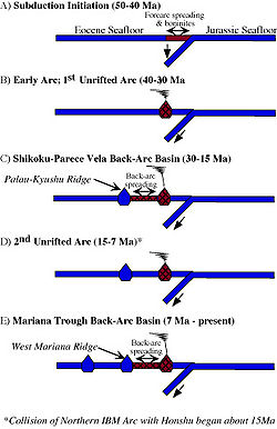
Back-arc basin
Back-arc basins are geologic features, submarine basins associated with island arcs and subduction zones.They are found at some convergent plate boundaries, presently concentrated in the Western Pacific ocean. Most of them result from tensional forces caused by oceanic trench rollback and the...
. The arc was disrupted during rifting but began to build again as a distinct magmatic system once seafloor spreading began. Arc volcanism, especially explosive volcanism, waned during much of this episode, with a resurgence beginning about 20 Ma in the south and about 17 Ma in the north. Tephra from northern and southern IBM show that strong compositional differences observed for the modern arc have existed over most of the arc's history, with northern IBM being more depleted and southern IBM being relatively enriched. About 15 Ma, the northernmost IBM began to collide with Honshū, probably as a result of new subduction along the Nankai Trough.
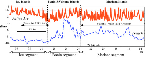
A new episode of rifting to form the Mariana Trough back-arc basin
Back-arc basin
Back-arc basins are geologic features, submarine basins associated with island arcs and subduction zones.They are found at some convergent plate boundaries, presently concentrated in the Western Pacific ocean. Most of them result from tensional forces caused by oceanic trench rollback and the...
began sometime after 10 Ma, with seafloor spreading beginning about 3-4 Ma. Because disruption of the arc is the first stage in forming any back-arc basin, the present Mariana arc volcanoes cannot be older than 3-4 Ma but the Izu-Bonin volcanoes could be as old as ~25 Ma. The Izu interarc rifts began to form about 2 Ma.
IBM Arc system components
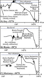
The forearc is that part of the arc system between the trench and the magmatic front of the arc and includes uplifted sectors of the forearc situated near the magmatic front, sometimes called the ‘frontal arc’. The IBM forearc from Guam to Japan is about 200 km wide. Uplifted portions of the forearc, composed of Eocene igneous basement surmounted by reef terraces of Eocene
Eocene
The Eocene Epoch, lasting from about 56 to 34 million years ago , is a major division of the geologic timescale and the second epoch of the Paleogene Period in the Cenozoic Era. The Eocene spans the time from the end of the Palaeocene Epoch to the beginning of the Oligocene Epoch. The start of the...
and younger age, produce the island chain from Guam north to Ferdinand de Medinilla in the Marianas. Similarly, the Bonin or Ogasawara Islands are mostly composed of Eocene igneous rocks. There is no accretionary prism
Accretionary wedge
An accretionary wedge or accretionary prism is formed from sediments that are accreted onto the non-subducting tectonic plate at a convergent plate boundary...
associated with the IBM forearc or trench.
The magmatic axis of the arc is well defined from Honshū to Guam. This ‘magmatic arc’ is often submarine, with volcanoes built on a submarine platform that lies between 1 and 4 km water depth. Volcanic islands are common in the Izu segment, including O-shima
Izu Oshima
is a volcanic island in the Izu Islands and administered by the Tokyo Metropolitan government, Japan, lies about 100 km south of Tokyo, 22 km east of the Izu Peninsula and 36 km southwest of Bōsō Peninsula. serves as the local government of the island...
, Hachijojima
Hachijojima
is a volcanic Japanese island in the Philippine Sea, administered by Tōkyō and located approximately south of the Special Wards of Tōkyō. It is the southernmost and most isolated of the Izu Seven Islands group of the seven northern islands of the Izu archipelago...
, and Miyakejima
Miyakejima
is an island in the Izu group, southeast of Honshū, Japan, administered by the Tokyo Metropolitan government, with an area of 55.50 km². The island, 180 km south of Tokyo, is located at 34.5N and 139.34E. As of January 1, 2006, the population of the island is 2884...
. The Izu segment farther south also contains several submarine felsic calderas. The Izu arc segment is also punctuated by inter-arc rifts. The Bonin segment to the south of the Sofugan Tectonic Line contains mostly submarine volcanoes and also some that rise slightly above sealevel, such as Nishino-shima. The Bonin segment is characterized by a deep basin, the Ogasawara Trough, between the magmatic arc and the Bonin Islands forearc uplift. The highest elevations in the IBM arc (not including the Izu Peninsula
Izu Peninsula
The is a large mountainous peninsula with deeply indented coasts to the west of Tokyo on the Pacific coast of the island of Honshū, Japan. Formerly the eponymous Izu Province, Izu peninsula is now a part of Shizuoka Prefecture...
, where IBM comes onshore in Japan) are found in the southern part of the Bonin segment, where the extinct volcanic islands of Minami Iwo Jima and Kita Iwo Jima rise to almost 1000 m above sealevel. The bathymetric high associated with magmatic arc of the Izu and Bonin segments is often referred to as the Shichito Ridge in Japanese publications, and the Bonins are often referred to as the Ogasawara Islands. Volcanoes erupting lavas of unusual composition – the shoshonitic province - are found in the transition between the Bonin and Mariana arc segments, including Iwo Jima
Iwo Jima
Iwo Jima, officially , is an island of the Japanese Volcano Islands chain, which lie south of the Ogasawara Islands and together with them form the Ogasawara Archipelago. The island is located south of mainland Tokyo and administered as part of Ogasawara, one of eight villages of Tokyo...
. The magmatic arc in the Marianas is submarine to the north of Uracas, south of which the Mariana arc includes volcanic islands (from north to south): Asuncion
Asuncion Island
Asuncion is the third northernmost independent island in the Northern Mariana Islands chain at .It is located in the far northern part of the Mariana arc of volcanic islands, situated northwest of Agrihan and southeast of the Maug Islands; the island of Pagan lies to the southwest...
, Maug, Agrigan
Agrihan
Agrihan is a stratovolcano which forms an island in the Northern Mariana Islands in the Pacific Ocean. The entire island is a massive volcano which rises over from the ocean floor, and is the fifth largest in the Marianas volcanic arc. At , its summit is the highest point in Micronesia...
, Pagan, Alamagan
Alamagan
The Northern Marianas island of Alamagan is located north from Saipan and is 11.12 km² in area. The island's volcano has a large caldera at the summit. The volcano last erupted around 870 AD, with an error bar of 100 years. It involved pyroclastic flows, and had a VEI of 4...
, Guguan
Guguan
Guguan is an island in the Northern Marianas island chain and is 130 miles north of Saipan. It measures only 3.87 km² but contains two volcanoes, one of which is active. A major eruption in 1883 produced pyroclastic flows as well as lava flows. The coast is bordered by steep basaltic rock with...
, Sarigan
Sarigan
Sarigan is a small island in the Northern Mariana Island chain. It is the result of a Holocene Era stratovolcano with no known historic eruptions, although a swarm of volcano-tectonic earthquakes took place here in the summer of 2005....
, and Anatahan
Anatahan
Anatahan is one of the most active volcanoes of the Northern Mariana Islands. The island of Anatahan is 9 kilometers long and has a land area of . Formerly inhabited, it now has no population because of the always-present danger of volcanic eruptions...
. Mariana volcanoes again becomes submarine south of Anatahan.
The back-arc regions of the three segments are quite different. The Izu segment is marked by several volcanic cross-chains which extend SW away from the magmatic front. The magmatically-starved Bonin arc segment has no back-arc basin, inter-arc rift, or rear-arc cross chains. The Mariana segment is characterized by an actively spreading back arc basin known as the Mariana Trough. The Mariana Trough shows marked variations along strike, with seafloor spreading south of 19°15’ and rifting farther north.
The IBM arc system southwest of Guam is markedly different than the region to the north. The forearc region is very narrow and the intersection of backarc basin spreading axis with the arc magmatic systems is complex.
Behavior and composition of the Western Pacific plate
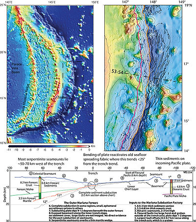
Everything on the Pacific plate that enters the IBM trench is subducted. The next section discusses some modifications of the lithosphere just prior to its descent and the age and composition of oceanic crust and sediments on the Pacific plate adjacent to the trench. In addition to subducted sediments and crust of the Pacific plate, there is also a very substantial volume of material from the overriding IBM forearc that is lost to the subduction zone by tectonic erosion .IBM Trench and outer trench swell
Oceanic trench
The oceanic trenches are hemispheric-scale long but narrow topographic depressions of the sea floor. They are also the deepest parts of the ocean floor....
and the associated outer trench swell
Outer trench swell
The outer trench swell, outer trench high, or outer rise is a subtle ridge on the seafloor near an oceanic trench, where a descending plate begins to flex and fault in preparation for its descent into the mantle at a subduction zone...
mark where Pacific Plate begins its descent into the IBM Subduction Zone. The IBM trench is where the Pacific Plate lithosphere
Lithosphere
The lithosphere is the rigid outermost shell of a rocky planet. On Earth, it comprises the crust and the portion of the upper mantle that behaves elastically on time scales of thousands of years or greater.- Earth's lithosphere :...
begins to sink. The IBM trench is devoid of any significant sediment fill; the ~400 m or so thickness of sediments is completely subducted with the downgoing plate. The IBM outer trench swell rises to about 300 m above the surrounding seafloor just before the trench. The lithosphere that is about to descend into a trench starts to bend just outboard of the trench; the seafloor is elevated into a broad swell that is a few hundred meters high and referred to as the "outer trench bulge" or “outer trench rise”. The about-to-be subducted plate is highly faulted, allowing seawater to penetrate into the plate interior, where hydration of mantle
Mantle (geology)
The mantle is a part of a terrestrial planet or other rocky body large enough to have differentiation by density. The interior of the Earth, similar to the other terrestrial planets, is chemically divided into layers. The mantle is a highly viscous layer between the crust and the outer core....
peridotite
Peridotite
A peridotite is a dense, coarse-grained igneous rock, consisting mostly of the minerals olivine and pyroxene. Peridotite is ultramafic, as the rock contains less than 45% silica. It is high in magnesium, reflecting the high proportions of magnesium-rich olivine, with appreciable iron...
may generate serpentinite
Serpentinite
Serpentinite is a rock composed of one or more serpentine group minerals. Minerals in this group are formed by serpentinization, a hydration and metamorphic transformation of ultramafic rock from the Earth's mantle...
. Serpentinite thus generated may carry water deep into the mantle as a result of subduction.
Geology and composition of the westernmost Pacific plate
The Pacific platePacific Plate
The Pacific Plate is an oceanic tectonic plate that lies beneath the Pacific Ocean. At 103 million square kilometres, it is the largest tectonic plate....
subducts in the IBM trench, so understanding what is subducted beneath IBM requires understanding the history of the western Pacific. The IBM arc system subducts mid-Jurassic
Jurassic
The Jurassic is a geologic period and system that extends from about Mya to Mya, that is, from the end of the Triassic to the beginning of the Cretaceous. The Jurassic constitutes the middle period of the Mesozoic era, also known as the age of reptiles. The start of the period is marked by...
to Early Cretaceous
Cretaceous
The Cretaceous , derived from the Latin "creta" , usually abbreviated K for its German translation Kreide , is a geologic period and system from circa to million years ago. In the geologic timescale, the Cretaceous follows the Jurassic period and is followed by the Paleogene period of the...
lithosphere
Lithosphere
The lithosphere is the rigid outermost shell of a rocky planet. On Earth, it comprises the crust and the portion of the upper mantle that behaves elastically on time scales of thousands of years or greater.- Earth's lithosphere :...
, with younger lithosphere in the north and older lithosphere in the south. It is not possible to directly know the composition of subducted materials presently being processed by the IBM Subduction Factory – what is now 130 km deep in the subduction zone entered the trench 4 – 10 million years ago. However, the composition of the western Pacific seafloor-oceanic crust
Oceanic crust
Oceanic crust is the part of Earth's lithosphere that surfaces in the ocean basins. Oceanic crust is primarily composed of mafic rocks, or sima, which is rich in iron and magnesium...
- sediments, crust, and mantle lithosphere - varies sufficiently systematically that, to a first approximation, we can understand what is now being processed by studying what lies on the seafloor east of the IBM trench.
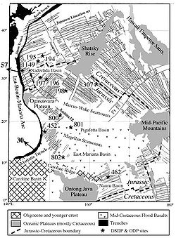
The Pacific plate seafloor east of the IBM arc system can be subdivided into a northern portion that is bathymetrically ‘smooth’ and a southern portion that is bathymetrically rugged, separated by the Ogasawara Plateau. These large-scale variations mark distinct geologic histories to the north and south. The featureless north is dominated by the Nadezhda Basin. In the south, crude alignments of seamount
Seamount
A seamount is a mountain rising from the ocean seafloor that does not reach to the water's surface , and thus is not an island. These are typically formed from extinct volcanoes, that rise abruptly and are usually found rising from a seafloor of depth. They are defined by oceanographers as...
s, atolls, and islands define three great, WNW-ESE trending chains : the Marcus Island-Wake Island
Wake Island
Wake Island is a coral atoll having a coastline of in the North Pacific Ocean, located about two-thirds of the way from Honolulu west to Guam east. It is an unorganized, unincorporated territory of the United States, administered by the Office of Insular Affairs, U.S. Department of the Interior...
-Ogasawara Plateau, the Magellan Seamounts Chain, and the Caroline Islands
Caroline Islands
The Caroline Islands are a widely scattered archipelago of tiny islands in the western Pacific Ocean, to the north of New Guinea. Politically they are divided between the Federated States of Micronesia in the eastern part of the group, and Palau at the extreme western end...
Ridge. The first two chains formed by off-ridge volcanism during Cretaceous
Cretaceous
The Cretaceous , derived from the Latin "creta" , usually abbreviated K for its German translation Kreide , is a geologic period and system from circa to million years ago. In the geologic timescale, the Cretaceous follows the Jurassic period and is followed by the Paleogene period of the...
time, whereas the Caroline Islands chain formed over the past 20 million years. Two important basins lie between these chains: the Pigafetta Basin lies between the Marcus-Wake and Magellan chains, and the East Mariana Basin lies between the Magellan and Caroline chains.
Geomagnetic reversal
A geomagnetic reversal is a change in the Earth's magnetic field such that the positions of magnetic north and magnetic south are interchanged. The Earth's field has alternated between periods of normal polarity, in which the direction of the field was the same as the present direction, and reverse...
timescale and confirmed by Ocean Drilling Program
Ocean Drilling Program
The Ocean Drilling Program was an international cooperative effort to explore and study the composition and structure of the Earth's ocean basins. ODP, which began in 1985, was the direct successor to the highly successful Deep Sea Drilling Project initiated in 1968 by the United States...
scientific drilling
Scientific drilling
Scientific drilling is a way to probe down into the Earth, allowing scientists and students to obtain samples of sediments, crust, and upper mantle. In addition to rock samples, drilling technology allows humans to obtain samples of connate fluids and of the subsurface biosphere, mostly microbial...
. Three major sets of magnetic anomalies have been identified in the area of interest. Each of these lineation sets comprises M-series (mid-Jurassic to mid-Cretaceous) magnetic anomalies that are essentially "growth rings" of the Pacific Plate. These anomaly sets indicate that the small, roughly triangular Pacific plate grew by spreading along three ridges . The oldest identifiable lineations are M33 to M35 or perhaps even M38 . It is difficult to say how old these lineations and the older crust might be; the oldest magnetic lineations for which ages have been assigned are M29 (157 Ma; . Magnetic lineations as old as M29 are not known from other oceans, and the area in the Western Pacific that lies inside the M29 lineation - that is, crust older than M29 - is on the order of 3x10⁶ km2, about a third of the size of the United States. ODP site 801 lies on seafloor that isconsiderably older than M29 and the MORB basement there yields Ar-Ar ages of 167±5 Ma . The oldest sediments at site 801C are midde Jurassic, Callovian
Callovian
In the geologic timescale, the Callovian is an age or stage in the Middle Jurassic, lasting between 164.7 ± 4.0 Ma and 161.2 ± 4.0 Ma. It is the last stage of the Middle Jurassic, following the Bathonian and preceding the Oxfordian....
or latest Bathonian
Bathonian
In the geologic timescale the Bathonian is an age or stage of the Middle Jurassic. It lasted from approximately 167.7 Ma to around 164.7 Ma...
(~162 Ma; ).
Seafloor spreading in the Pacific during the Cretaceous
Cretaceous
The Cretaceous , derived from the Latin "creta" , usually abbreviated K for its German translation Kreide , is a geologic period and system from circa to million years ago. In the geologic timescale, the Cretaceous follows the Jurassic period and is followed by the Paleogene period of the...
evolved from a more E-W 'Tethyan'
Tethys Ocean
The Tethys Ocean was an ocean that existed between the continents of Gondwana and Laurasia during the Mesozoic era before the opening of the Indian Ocean.-Modern theory:...
orientation to the modern N-S trend. This occurred during mid-Cretaceous time, a ~35-40 Ma interval characterized by a lack of magnetic reversals known as the Cretaceous Superchron or Quiet Zone. Subsequently, the location of N-S trending spreading ridges relative to the Pacific Basin migrated progressively to the east throughout Cretaceous and Tertiary time, resulting in the present marked asymmetry of the Pacific, with very young seafloor in the Eastern Pacific and very old seafloor in the Western Pacific.
Sediments being delivered to the IBM trench are not thick considering that this some of Earth's oldest seafloor. Away from seamounts, the pelagic sequence is dominated by chert and pelagic clay, with little carbonate. Carbonates are important near guyots, common in the southern part of the region. Interestingly, Cenozoic sediments are unimportant except for volcanic ash
Volcanic ash
Volcanic ash consists of small tephra, which are bits of pulverized rock and glass created by volcanic eruptions, less than in diameter. There are three mechanisms of volcanic ash formation: gas release under decompression causing magmatic eruptions; thermal contraction from chilling on contact...
and Asian loess
Loess
Loess is an aeolian sediment formed by the accumulation of wind-blown silt, typically in the 20–50 micrometre size range, twenty percent or less clay and the balance equal parts sand and silt that are loosely cemented by calcium carbonate...
deposited adjacent to Japan and carbonate sediments associated with the relatively shallow Caroline Ridge and Caroline plate
Caroline Plate
The Caroline Plate is a small tectonic plate located north of New Guinea. It forms a subduction zone along the border with the Bird's Head Plate and the Woodlark Plate to the south. A transform boundary forms the northern border with the Pacific Plate. Along the border with the Philippine Sea Plate...
. Strong seafloor currents are probably responsible for this erosion or non-deposition.
The compositions of sediments being subducted beneath the northern and southern parts of the IBM arc are significantly different, because of the Cretaceous off-ridge volcanic succession in the south that is missing in the north. Lavas and volcaniclastics associated with an intense episode of intraplate volcanism correspond in time closely to the Cretaceous Superchron. Off-ridge volcanism became increasingly important approaching the Ontong-Java Plateau. There are 100–400 m thick tholeiitic
Tholeiite
The tholeiitic magma series is one of two main magma series in igneous rocks, the other magma series being the calc–alkaline. A magma series is a series of compositions that describes the evolution of a mafic magma, which is high in magnesium and iron and produces basalt or gabbro, as it...
sills
Sill (geology)
In geology, a sill is a tabular sheet intrusion that has intruded between older layers of sedimentary rock, beds of volcanic lava or tuff, or even along the direction of foliation in metamorphic rock. The term sill is synonymous with concordant intrusive sheet...
in the East Mariana Basin and Pigafetta Basin , and at least 650 m of tholeiitic flows and sills in the Nauru Basin, near ODP Site 462. suggest that this province may reflect the formation of a mid-Cretaceous spreading system in the Nauru and East Mariana basins. Farther north, deposits related to this episode consist of thick sequences of Aptian
Aptian
The Aptian is an age in the geologic timescale or a stage in the stratigraphic column. It is a subdivision of the Early or Lower Cretaceous epoch or series and encompasses the time from 125.0 ± 1.0 Ma to 112.0 ± 1.0 Ma , approximately...
-Albian
Albian
The Albian is both an age of the geologic timescale and a stage in the stratigraphic column. It is the youngest or uppermost subdivision of the Early/Lower Cretaceous epoch/series. Its approximate time range is 112.0 ± 1.0 Ma to 99.6 ± 0.9 Ma...
volcaniclastic turbidites shed from emerging volcanic islands, such as preserved at DSDP site 585 and ODP sites 800 and 801. A few hundred meters of volcaniclastic deposits probably characterizes the sedimentary succession in and around the East Mariana and Pigafetta basins. Farther north, at DSDP sites 196 and 307 and ODP site 1149, there is little evidence of mid-Cretaceous volcanic activity. It appears that the Aptian-Albian volcanic episode was largely restricted to the region south of present 20°N latitude. Paleomagnetic and plate kinematic considerations place this broad region of off-ridge volcanism in the present vicinity of Polynesia
Polynesia
Polynesia is a subregion of Oceania, made up of over 1,000 islands scattered over the central and southern Pacific Ocean. The indigenous people who inhabit the islands of Polynesia are termed Polynesians and they share many similar traits including language, culture and beliefs...
, where today off-ridge volcanism, shallow bathymetry, and thin lithosphere is known as the 'Superswell' .
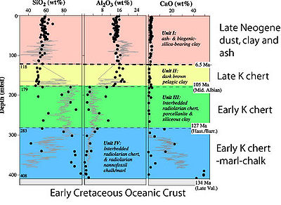
Ocean Drilling Program
The Ocean Drilling Program was an international cooperative effort to explore and study the composition and structure of the Earth's ocean basins. ODP, which began in 1985, was the direct successor to the highly successful Deep Sea Drilling Project initiated in 1968 by the United States...
site 1149, east of the Izu-Bonin segment. The sediments drilled at ODP site 1149 are about 400 m thick and are as old as 134 million years. The sedimentary section is a typical pelagic stratigraphy
Stratigraphy
Stratigraphy, a branch of geology, studies rock layers and layering . It is primarily used in the study of sedimentary and layered volcanic rocks....
, accumulated mostly in the Cretaceous but also in the last 7 million years (late Neogene
Neogene
The Neogene is a geologic period and system in the International Commission on Stratigraphy Geologic Timescale starting 23.03 ± 0.05 million years ago and ending 2.588 million years ago...
) built on a basement of Early Cretaceous
Cretaceous
The Cretaceous , derived from the Latin "creta" , usually abbreviated K for its German translation Kreide , is a geologic period and system from circa to million years ago. In the geologic timescale, the Cretaceous follows the Jurassic period and is followed by the Paleogene period of the...
oceanic crust. The lowermost portion is carbonate and chert, the next layer is very chert-rich, the third layer is clay-rich. This is followed by a long depositional hiatus before sedimentation resumes ~6.5 Ma (Late Miocene
Miocene
The Miocene is a geological epoch of the Neogene Period and extends from about . The Miocene was named by Sir Charles Lyell. Its name comes from the Greek words and and means "less recent" because it has 18% fewer modern sea invertebrates than the Pliocene. The Miocene follows the Oligocene...
), with deposition of volcanic ash, clay, and windblown dust. The stratigraphy east of the Mariana segment differs from that being subducted beneath the Izu-Bonin segment in having a much greater abundance of Early Cretaceous intra-plate volcanics and flood basalts.
About 470m of oceanic crust
Oceanic crust
Oceanic crust is the part of Earth's lithosphere that surfaces in the ocean basins. Oceanic crust is primarily composed of mafic rocks, or sima, which is rich in iron and magnesium...
was penetrated at ODP site 801C during Legs 129 and 185. These are typical mid-ocean ridge basalt that were affected by low-temperature hydrothermal alteration. This crust is overlain by a 3 m thick, bright yellow hydrothermal deposit and about 60 m of alkali olivine basalt
Basalt
Basalt is a common extrusive volcanic rock. It is usually grey to black and fine-grained due to rapid cooling of lava at the surface of a planet. It may be porphyritic containing larger crystals in a fine matrix, or vesicular, or frothy scoria. Unweathered basalt is black or grey...
, 157.4±0.5 Ma old .
Geophysics of the subducted slab and mantle
The deep structure of the IBM system has been imaged using a variety of geophysical techniquesGeophysics
Geophysics is the physics of the Earth and its environment in space; also the study of the Earth using quantitative physical methods. The term geophysics sometimes refers only to the geological applications: Earth's shape; its gravitational and magnetic fields; its internal structure and...
. This section provides an overview of these data, including a discussion of mantle
Mantle (geology)
The mantle is a part of a terrestrial planet or other rocky body large enough to have differentiation by density. The interior of the Earth, similar to the other terrestrial planets, is chemically divided into layers. The mantle is a highly viscous layer between the crust and the outer core....
structure at depths >200 km.
Seismicity
Spatial patterns of seismicity are essential for locating and understanding the morphology and rheologyRheology
Rheology is the study of the flow of matter, primarily in the liquid state, but also as 'soft solids' or solids under conditions in which they respond with plastic flow rather than deforming elastically in response to an applied force....
of subducting lithospheric
Lithosphere
The lithosphere is the rigid outermost shell of a rocky planet. On Earth, it comprises the crust and the portion of the upper mantle that behaves elastically on time scales of thousands of years or greater.- Earth's lithosphere :...
slabs
Slab (geology)
In geology, a slab is the portion of a tectonic plate that is being subducted.Slabs constitute an important part of the global plate tectonic system. They drive plate tectonics both by pulling along the lithosphere to which they are attached in a processes known as slab pull and by inciting...
, and this is particularly true for the IBM Wadati-Benioff zone (WBZ). first outlined the most important features of the IBM WBZ. Their study detected a zone of deep earthquakes beneath the southern Marianas and provided some of the first constraints on the deep, vertical nature of subducting Pacific lithosphere beneath southern IBM. They also found a region of reduced shallow seismicity (≤70 km) and an absence of deep (≥ 300 km) events beneath the Volcano Islands adjacent to the junction of the Izu Bonin and Mariana trenches, where the trench trends nearly parallel to the convergence vector.
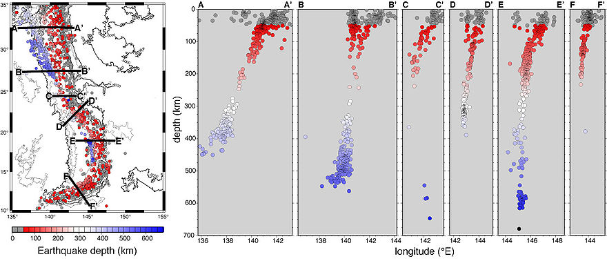
Deep earthquakes, here defined as seismic events ≥300 km deep, are common beneath parts of the IBM arc system (Figures 10, 11). Deep events in the IBM system are less frequent than for most other subduction zones with deep seismicity, such as Tonga/Fiji/Kermadec and South America. Beneath northern IBM, deep seismicity extends southward to ~27.5°N, and a small pocket of events between 275 km and 325 km depth exists at ~22°N. There is narrow band of deep earthquakes beneath southern IBM between ~21°N and ~17°N, but south of this there are extremely few deep events. Although early studies assumed that seismicity demarcated the upper boundary of the slab, more recent evidence has shown that many of these earthquakes occur within the slab. For instance, a study by showed that a region of events beneath northernmost IBM region occur ~20 km beneath the top of the subducting plate. They propose that transformational faulting, which occurs when metastable olivine changes to a more compact spinel structure, produces this zone of seismicity. Indeed, the faulting mechanism for deep earthquakes is a hotly debated topic (e.g.), and has yet to be resolved.
Double seismic zones (DSZs) have been detected in several parts of the IBM subduction zone, but their locations within the slab as well as interpretations for their existence vary dramatically. Beneath southern IBM, found a DSZ lying 80 km and 120 km deep, with the two zones separated by 30 35 km. Earthquake focal mechanism
Focal mechanism
The focal mechanism of an earthquake describes the inelastic deformation in the source region that generates the seismic waves. In the case of a fault-related event it refers to the orientation of the fault plane that slipped and the slip vector and is also known as a fault-plane solution...
s indicate that the upper zone, where most events occur, is in downdip compression, while the lower zone is in downdip extension. This DSZ is located at a depth where the curvature of slab is greatest; at greater depths it unbends into a more planar donfiguration. suggested that unbending or thermal stresses in the upper 150 km of the slab may the primary cause of the seismicity. For northern IBM, used a refined earthquake relocation scheme to detect a DSZ between depths of 300 km and 400 km, which also has a spacing of 30 35 km between the upper and lower zones. They interpreted data from S to P converted phases and thermal modeling to propose that the DSZ results from transformational faulting of a metastable olivine wedge in the slab. Recent work suggests that compositional variations in the subducting slab may also contribute to double seismic zone , or that DSZs represent the locus of serpentine dehydration in the slab .
Mariana Arc Volcanism and Hydrothermal Activity
Bathymetry of the Mariana arc region , showing all 51 edifices presently named along the volcanic front between 12°30’N and 23°10’N. Hydrothermally or volcanically active submarine edifices are labeled red; active subaerial edifices are labeled green. Inactive submarine and subaerial edifices are labeled in smaller black and green font, respectively. For all edifices, caldera labels are in bold italics. Black circles (20 km diameter) identify those volcanic centers composed of multiple individual edifices. Solid red line is the backarc spreading center.Arc Volcanism
identified 76 volcanic edifices along 1370 km of the Mariana arc, grouped into 60 ‘‘volcanic centers,’’ of which at least 26 (20 submarine) are hydrothermally or volcanically active. The overall volcanic center density is 4.4/100 km of arc, and that of active centers is 1.9/100 km. Active volcanoes lie 80 to 230 km above the subducting Pacific plate, and ~25% lie behind the arc magmatic front. There is no evidence for a regular spacing of volcanoes along the Mariana arc. The frequency distribution of volcano spacing along the arc magmatic front peaks between 20 and 30 km and shows the asymmetric, long-tail shape typical for many other arcs. The first global compilation of arc volcanoes using recent bathymetric data estimated that arcs that are at least partially submarine have a population of almost 700 volcanoes, of which at least 200 are submerged .Arc Hydrothermal Activity
estimated that intraoceanic arcs combined may contribute hydrothermal emissions equal to ~10% of that from the global mid-ocean ridge system.See also
- Mariana TroughMariana TroughThe Mariana Trough is an active back-arc basin in the western Pacific Ocean . It is an integral part of the Izu-Bonin-Mariana Arc system.-Location and Bathymetry:...
- Mariana TrenchMariana TrenchThe Mariana Trench or Marianas Trench is the deepest part of the world's oceans. It is located in the western Pacific Ocean, to the east of the Mariana Islands. The trench is about long but has a mean width of only...
- Northern Mariana IslandsNorthern Mariana IslandsThe Northern Mariana Islands, officially the Commonwealth of the Northern Mariana Islands , is a commonwealth in political union with the United States, occupying a strategic region of the western Pacific Ocean. It consists of 15 islands about three-quarters of the way from Hawaii to the Philippines...
- South Chamorro SeamountSouth Chamorro SeamountSouth Chamorro Seamount is a large serpentinite mud volcano and seamount located in the Izu-Bonin-Mariana Arc, one of 16 such volcanoes in the arc. These seamounts are at their largest in diameter and in height...
External links
- http://volcano.und.edu/vwdocs/volc_images/southeast_asia/mariana/basic_geology.htm - VolcanoWorld about the Mariana arc subaerial volcanoes
- http://www.pmel.noaa.gov/vents/marianas/multimedia06.html - NOAA Ring of Fire 2006 investigations in the Mariana arc - cool videos etc.
- http://oceanexplorer.noaa.gov/explorations/04fire/welcome.html - NOAA Ring of Fire 2004 investigations in the Mariana arc - cool videos etc.
- http://oceanexplorer.noaa.gov/explorations/03fire/welcome.html - NOAA Ring of Fire 2003 investigations in the Mariana arc - cool videos etc.
- http://vids.myspace.com/index.cfm?fuseaction=vids.channel&ChannelID=33358833 - interview with Dr. R. Embley about NOAA studies of Mariana submarine volcanoes
- http://www.nsf-margins.org/IBM07/ - information about a 2007 geoscientific meeting concerned with the IBM arc, including presentations and posters that can be downloaded.
- http://www.volcano.si.edu/world/region.cfm?rnum=0804 - Volcanoes of the IBM arc