
Istanbul Province
Encyclopedia
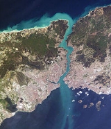
Istanbul Province is a province
located in north-west Turkey
. It has an area of 5,196 km² and a population of 13,255,685. The population was 10,018,735 in 2000. It is surrounded by the provinces of Tekirdağ
to the west, Kocaeli
to the east, the Black Sea
to the northern part and the Sea of Marmara
to the south. The Bosphorus (Boğaziçi) Strait divides the province in two parts: the Europe
an side and the Asia
n side.
The capital of the province is the city of Istanbul
, which, since 2004, has the same boundaries as the province.
The province also includes the Princes' Islands
constitued as Adalar District (Island District).
Provinces of Turkey
Turkey is divided into 81 provinces, called il in Turkish .A province is administered by an appointed governor , and was formerly termed a "governorate" ....
located in north-west Turkey
Turkey
Turkey , known officially as the Republic of Turkey , is a Eurasian country located in Western Asia and in East Thrace in Southeastern Europe...
. It has an area of 5,196 km² and a population of 13,255,685. The population was 10,018,735 in 2000. It is surrounded by the provinces of Tekirdağ
Tekirdag Province
The Tekirdağ Province is in Trakya , the northwestern part of Turkey. The capital city is Tekirdağ. It is famous for its meatball called "Tekirdağ köfte" and the Turkish alcoholic drink called Tekirdağ rakısı.-Districts:...
to the west, Kocaeli
Izmit
İzmit is a city in Turkey, administrative center of Kocaeli Province as well as the Kocaeli Metropolitan Municipality. It is located at the Gulf of İzmit in the Sea of Marmara, about east of Istanbul, on the northwestern part of Anatolia. The city center has a population of 294.875...
to the east, the Black Sea
Black Sea
The Black Sea is bounded by Europe, Anatolia and the Caucasus and is ultimately connected to the Atlantic Ocean via the Mediterranean and the Aegean seas and various straits. The Bosphorus strait connects it to the Sea of Marmara, and the strait of the Dardanelles connects that sea to the Aegean...
to the northern part and the Sea of Marmara
Sea of Marmara
The Sea of Marmara , also known as the Sea of Marmora or the Marmara Sea, and in the context of classical antiquity as the Propontis , is the inland sea that connects the Black Sea to the Aegean Sea, thus separating Turkey's Asian and European parts. The Bosphorus strait connects it to the Black...
to the south. The Bosphorus (Boğaziçi) Strait divides the province in two parts: the Europe
Europe
Europe is, by convention, one of the world's seven continents. Comprising the westernmost peninsula of Eurasia, Europe is generally 'divided' from Asia to its east by the watershed divides of the Ural and Caucasus Mountains, the Ural River, the Caspian and Black Seas, and the waterways connecting...
an side and the Asia
Asia
Asia is the world's largest and most populous continent, located primarily in the eastern and northern hemispheres. It covers 8.7% of the Earth's total surface area and with approximately 3.879 billion people, it hosts 60% of the world's current human population...
n side.
The capital of the province is the city of Istanbul
Istanbul
Istanbul , historically known as Byzantium and Constantinople , is the largest city of Turkey. Istanbul metropolitan province had 13.26 million people living in it as of December, 2010, which is 18% of Turkey's population and the 3rd largest metropolitan area in Europe after London and...
, which, since 2004, has the same boundaries as the province.
The province also includes the Princes' Islands
Princes' Islands
The Princes' Islands , are a chain of nine islands off the coast of Istanbul, Turkey, in the Sea of Marmara. The islands also constitute the Adalar district of Istanbul Province...
constitued as Adalar District (Island District).
Cities
| Rank | City | 1990 Census | 2000 Census | 2007 Census | 2008 Estimate |
|---|---|---|---|---|---|
| 1 | Istanbul Istanbul Istanbul , historically known as Byzantium and Constantinople , is the largest city of Turkey. Istanbul metropolitan province had 13.26 million people living in it as of December, 2010, which is 18% of Turkey's population and the 3rd largest metropolitan area in Europe after London and... |
8,629,431 | 10,803,468 | 12,573,836 | 12,697,164 |
| 2 | Sultanbeyli Sultanbeyli Sultanbeyli is a working class suburb of Istanbul, Turkey on the Asian side, inland from Kartal and Pendik. It has a population of 272,758 , more than triple the 1990 figure of 82,298. The mayor is Hüseyin Keskin .- History :... |
82,298 | 175,700 | 272,758 | 283,962 |
| 3 | Esenyurt Esenyurt Esenyurt is a district of the Istanbul Province and is a part of the metropolitan municipality of Istanbul. It is situated in the western, European part of the city and had a population of 403,895 inhabitants by the end of 2009. The mayor is Necmi Kadıoğlu .-External links:* www.esenyurthaber.com... |
70,280 | 148,981 | 253,084 | 263,837 |
| 4 | Beylikdüzü Beylikdüzü Beylikdüzü is a district in the suburbs of Istanbul, Turkey. The mayor is Yusuf Uzun .... |
2,500 | 39,884 | 112,131 | 122,452 |
| 5 | Samandıra | 22,888 | 67,438 | 112,653 | 117,933 |
| 6 | Sarıgazi | 22,125 | 48,466 | 76,855 | 80,911 |
| 7 | Çekmeköy Çekmeköy Çekmeköy is a district in the suburbs of Istanbul, Turkey. In 2007, the population of Çekmeköy was 70,683.... |
13,523 | 37,502 | 70,683 | 75,423 |
| 8 | Kıraç Kiraç Ali Tufan Kıraç , better known as Kıraç, 1972 is a Turkish musician, known as a composer and performing artist.He has contributed albums such as Kayıp Şehir, Zaman and many others... |
2,239 | 28,810 | 63,293 | 68,219 |
| 9 | Arnavutköy Arnavutköy (district) Arnavutköy is a city and a rural district in Istanbul Province, Turkey, newly formed in 2008 from the large rural part of Gaziosmanpaşa district and parts of other districts, in particular Çatalca. The mayor is Ahmet Haşim Baltacı .... |
21,143 | 45,557 | 62,492 | 64,911 |
| 10 | Silivri Silivri Silivri is a city and a district in Istanbul Province along the Sea of Marmara in Turkey, outside of metropolitan Istanbul, containing many holiday and weekend homes for residents of the city. The largest city in the district is also named Silivri... |
26,049 | 44,530 | 62,247 | 64,376 |
| 11 | Yakuplu | 2,841 | 31,676 | 51,862 | 54,746 |
| 12 | Yenidoğan | 1,200 | 28,447 | 49,593 | 52,614 |
| 13 | Gürpınar Gürpinar Gürpınar is a district of Van Province and south of Van. Gurpinar's total area is 4700 km2 and is the largest area of the districts of Turkey. It has 72 villages and many historical areas.- History :... |
10,191 | 31,068 | 45,682 | 47,770 |
| 14 | Büyükçekmece Büyükçekmece Büyükçekmece is a district and municipality in the suburbs of Istanbul, Turkey on the Sea of Marmara coast of the European side, west of the city. It is largely an industrial area with a population of 380,000... |
22,394 | 35,860 | 44,287 | 45,575 |
| 15 | Taşdelen | 9,747 | 28,216 | 39,774 | 41,425 |
| 16 | Mimarsinan | 7,690 | 25,828 | 39,244 | 41,156 |
| 17 | Tepecik | 12,240 | 18,798 | 33,192 | 35,248 |
| 18 | Çatalca Çatalca Çatalca is a city and a rural district in Istanbul, Turkey. It is in Thrace, on the ridge between the Marmara and the Black Sea. Most people living in Çatalca are either farmers or those visiting vacation homes. Many families from Istanbul come to Çatalca during weekends to hike in the forests or... |
11,550 | 15,779 | 27,807 | 28,763 |
| 19 | Bahçeşehir | 2,500 | 19,018 | 25,116 | 25,987 |
| 20 | Boğazköy | 4,495 | 15,850 | 22,410 | 23,347 |
| 21 | Kumburgaz | 7,118 | 10,352 | 20,883 | 22,387 |
| 22 | Alemdağ | 6,684 | 15,277 | 21,292 | 22,151 |
| 23 | Hadımköy | 6,486 | 14,278 | 19,733 | 20,512 |
| 24 | Çavuşbaşı | 4,693 | 15,753 | 19,539 | 20,080 |
| 25 | Taşoluk | 2,527 | 20,000 | 13,068 | 13,688 |
| 26 | Selimpaşa Selimpaşa Selimpaşa, known in Byzantine times as Epibates is a small town in the European part of Turkey, near Silivri in Istanbul Province.The city is located on the northwestern coast of the Marmara Sea, west of Istanbul and east from Silivri on the highway . The town is a native place of the Orthodox... |
8,401 | 9,151 | 11,955 | 12,356 |
| 27 | Orhanlı | 2,735 | 6,048 | 11,314 | 11,819 |
| 28 | Bolluca | 2,409 | 7,320 | 10,875 | 11,373 |
| 29 | Haraççı | 2,671 | 8,520 | 10,266 | 10,713 |
| 30 | Bahçeköy | 4,072 | 6,107 | 9,847 | 10,381 |
Districts
|
Çekmeköy Çekmeköy is a district in the suburbs of Istanbul, Turkey. In 2007, the population of Çekmeköy was 70,683.... Esenler Esenler is a district of Istanbul, Turkey, on its European side. Esenler is mainly densely packed, working class residential in the midst of its industrial neighbouring districts of Gaziosmanpaşa, Güngören and Bağcılar... Esenyurt Esenyurt is a district of the Istanbul Province and is a part of the metropolitan municipality of Istanbul. It is situated in the western, European part of the city and had a population of 403,895 inhabitants by the end of 2009. The mayor is Necmi Kadıoğlu .-External links:* www.esenyurthaber.com... Eyüp -External links:* * * * *... Fatih Fatih is a municipality and district in Istanbul, Turkey that encompasses most of the peninsula coinciding with historic Constantinople. In 2009, the district of Eminönü, formerly a separate municipality located at the tip of the peninsula, was merged into Fatih... Gaziosmanpasa Gaziosmanpaşa is an impoverished working class municipality and district of Istanbul, Turkey, on its European side. With a population of 400,000 plus, it is one of the most populous districts. In 2009 Gaziosmanpaşa district were the divided to three districts: Gaziosmanpaşa, the central;... Güngören Güngören is a small industrial and working class residential district of Istanbul, Turkey. It is located near the district of Bakırköy. The mayor is Şakir Yücel Karaman .-History:... Kadiköy Kadıköy is a large, populous, and cosmopolitan district of İstanbul, Turkey on the Asian side of the Sea of Marmara, facing the historic city centre on the European side of the Bosporus... Kagithane Kağıthane is a working class district of the city of Istanbul, Turkey, in a valley inland from the upmarket Etiler. Built along a stream that runs into the Golden Horn. The mayor is Fazlı Kılıç .-History:... Kartal Kartal is a district of Istanbul, Turkey located on the Asian side of the city, on the coast of the Marmara Sea between Maltepe and Pendik. The mayor is Altınok Öz . Despite being far from the city centre, Kartal is heavily populated now. . Total land area is 147,000 m² which includes some... Küçükçekmece Küçükçekmece is a large, crowded suburb on the European side of Istanbul, Turkey 23 km out of the city, beyond Atatürk Airport. The population of the area reaches 600,000. This area covers 118 km².-Location:... |
Pendik Pendik is a district of Istanbul, Turkey on the Asian side between Kartal and Tuzla, on the Marmara Sea. Its population is 625.365 and its mayor is Salih Kenan Şahin .-History:... Sancaktepe Sancaktepe is a district in the suburbs of Istanbul, Turkey. It became a district in the year 2008.... Sariyer Sarıyer is the northernmost district of Istanbul, Turkey, on the European side of the city. With a long shore along the water, the district boasts both a beautiful coastline and a lush forest. The Sarıyer district is a huge area consisting of the villages on the European side of the Bosphorus from... Sultanbeyli Sultanbeyli is a working class suburb of Istanbul, Turkey on the Asian side, inland from Kartal and Pendik. It has a population of 272,758 , more than triple the 1990 figure of 82,298. The mayor is Hüseyin Keskin .- History :... Sultangazi Sultangazi is one of Istanbul's new districts. It was founded in 2008 for "New Local Government Law" in Istanbul, Turkey.Esenler and Başakşehir are at west, Gaziosmanpaşa is at south, and Eyüp is at north and east. Gaziosmanpaşa district were the divided to three districts, Sultangazi is one of... Sile Şile is a small holiday city on the Black Sea, 70 km from the city of Istanbul, Turkey. Şile is the also the name of the district and the municipality that contain the city center of Şile... Sisli Şişli is one of 39 districts of Istanbul, Turkey. Located on the European side of the city, it is bordered by Beşiktaş to the east, Sarıyer to the north, Eyüp and Kağıthane to the west, and Beyoğlu to the south... Tuzla (district) Tuzla is a small town, a suburb of Istanbul, Turkey on the Asian side of the city beyond Kartal and Pendik. Tuzla is on a headland on the coast of the Marmara Sea, at the eastern limit of the city. The mayor is Şadi Yazıcı .-History:... Ümraniye Ümraniye is a very large working class district of Istanbul, Turkey with a population of over 250,000. It became district in 1987 by secession from Üsküdar. Also; Ömerli, Koçullu, Sırapınar and Hüseyinli villages were separated from Beykoz district in same year. Finally, Nişantepe quarter passed... Üsküdar Üsküdar is a large and densely populated municipality of Istanbul, Turkey, on the Anatolian shore of the Bosphorus. It is bordered on the north by Beykoz, on the east by Ümraniye, on the southeast by Ataşehir, on the south by Kadıköy, and on the west by the Bosphorus, with the areas of Beşiktaş,... Zeytinburnu Zeytinburnu is a working class neighbourhood, municipality and district on the European side of İstanbul, Turkey, on the shore of the Marmara Sea just outside the walls of the ancient city, beyond the fortress of Yedikule... |