

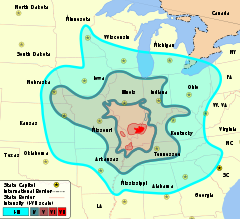
Isoseismal map
Encyclopedia
Seismology
Seismology is the scientific study of earthquakes and the propagation of elastic waves through the Earth or through other planet-like bodies. The field also includes studies of earthquake effects, such as tsunamis as well as diverse seismic sources such as volcanic, tectonic, oceanic,...
an isoseismal map is used to show lines of equal felt seismic intensity, generally measured on the Modified Mercalli scale. Such maps help to identify earthquake
Earthquake
An earthquake is the result of a sudden release of energy in the Earth's crust that creates seismic waves. The seismicity, seismism or seismic activity of an area refers to the frequency, type and size of earthquakes experienced over a period of time...
epicenter
Epicenter
The epicenter or epicentre is the point on the Earth's surface that is directly above the hypocenter or focus, the point where an earthquake or underground explosion originates...
s, particularly where no instrumental
Seismometer
Seismometers are instruments that measure motions of the ground, including those of seismic waves generated by earthquakes, volcanic eruptions, and other seismic sources...
records exist, such as for historical earthquakes
Historical earthquakes
Historical earthquakes is a list of significant earthquakes from before the 20th century. As the events listed here occurred before routine instrumental recordings, they rely mainly on the analysis of written sources. There is often significant uncertainty in location and magnitude and sometimes...
. They also contain important information on ground conditions at particular locations, the underlying geology
Geology
Geology is the science comprising the study of solid Earth, the rocks of which it is composed, and the processes by which it evolves. Geology gives insight into the history of the Earth, as it provides the primary evidence for plate tectonics, the evolutionary history of life, and past climates...
, radiation pattern of the seismic wave
Seismic wave
Seismic waves are waves of energy that travel through the earth, and are a result of an earthquake, explosion, or a volcano that imparts low-frequency acoustic energy. Many other natural and anthropogenic sources create low amplitude waves commonly referred to as ambient vibrations. Seismic waves...
s and the response of different types of buildings. They form an important part of the macroseismic approach, i.e. that part of seismology dealing with non-instrumental data. The shape and size of the isoseismal regions can be used to help determine the magnitude, focal depth and focal mechanism
Focal mechanism
The focal mechanism of an earthquake describes the inelastic deformation in the source region that generates the seismic waves. In the case of a fault-related event it refers to the orientation of the fault plane that slipped and the slip vector and is also known as a fault-plane solution...
of an earthquake.
History
The first known isoseismal map was produced for the 1810 earthquake in MórMór
Mór is a town in Fejér county, Hungary. Among the smaller towns in the middle Transdanubian region of Hungary, it lies between Vértes and Bakony Hills, in the northwestern corner of Fejér Country. The historic roots of the present town go back to the Celtic an Roman Period...
in Hungary
Hungary
Hungary , officially the Republic of Hungary , is a landlocked country in Central Europe. It is situated in the Carpathian Basin and is bordered by Slovakia to the north, Ukraine and Romania to the east, Serbia and Croatia to the south, Slovenia to the southwest and Austria to the west. The...
was published by Kitaibel and Tomtsányi in 1814. The first, six-level intensity scale was proposed by Egen in 1828 for an earthquake in Rhineland
Rhineland
Historically, the Rhinelands refers to a loosely-defined region embracing the land on either bank of the River Rhine in central Europe....
. Robert Mallet
Robert Mallet
Robert Mallet FRS , Irish geophysicist, civil engineer, and inventor who distinguished himself in research on earthquakes and is sometimes called the father of seismology.-Early life:...
coined the term 'isoseismal' and produced a map for the 1857 Great Neapolitan Earthquake
Great Neapolitan Earthquake
The Great Neapolitan Earthquake was an earthquake that occurred on December 16, 1857, in the Basilicata region of Italy southeast of the city of Naples. The epicentre was in Montemurro, on the western border of the modern province of Potenza. Several towns were destroyed, and estimated fatalities...
with a threefold intensity scale and used this and other information to identify the epicentral area (a term he also coined). Later studies made use of similar techniques, the main changes being to the actual seismic intensity scale employed.
Methodology
Firstly observations of the felt intensity need to be obtained for all areas affected by the tremor. In the case of recent earthquakes news reports are augmented by sending out questionnaires or by collecting information online about the intensity of the shaking. For a historical earthquake the procedure is much the same, except that it requires searching through contemporary accounts in newspapers, letters and diaries etc. Once the information has been assembled and intensities assigned at the location of the individual observations, these are plotted on a map. Isoseismal lines are then drawn to link together areas of equal shaking. Because of local variations in the ground conditions isoseismals will generally separate zones of broadly similar felt intensity, while containing areas of both higher and lower degrees of shaking. To make the isoseismals less subjective, attempts have been made to use computer-based methods of contouring such as krigingKriging
Kriging is a group of geostatistical techniques to interpolate the value of a random field at an unobserved location from observations of its value at nearby locations....
, rather than relying on visual interpolation
Interpolation
In the mathematical field of numerical analysis, interpolation is a method of constructing new data points within the range of a discrete set of known data points....
.