
Islands of Indonesia
Encyclopedia
Indonesia
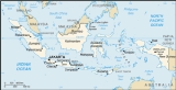
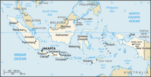
Indonesia , officially the Republic of Indonesia , is a country in Southeast Asia and Oceania. Indonesia is an archipelago comprising approximately 13,000 islands. It has 33 provinces with over 238 million people, and is the world's fourth most populous country. Indonesia is a republic, with an...
comprises 17,508 - 18,306 island
Island
An island or isle is any piece of sub-continental land that is surrounded by water. Very small islands such as emergent land features on atolls can be called islets, cays or keys. An island in a river or lake may be called an eyot , or holm...
s and 8,844 that have been named according to estimates made by the Government of Indonesia
Politics of Indonesia
Politics of Indonesia takes place in a framework of a presidential representative democratic republic, whereby the President of Indonesia is both head of state and head of government, and of a multi-party system. Executive power is exercised by the government. Legislative power is vested in both...
, with 922 of those permanently inhabited. The islands span 5400 kilometres (3,355.4 mi) eastward from Sabang
Sabang
Sabang is a city consisting of several islands in Aceh, Indonesia. The metropolitan area is located on Weh Island, 17 km north of Banda Aceh. The city covers an area of 118 square kilometres and according to the 2000 census had a population of 23,654 people...
in northern Sumatra
Sumatra
Sumatra is an island in western Indonesia, westernmost of the Sunda Islands. It is the largest island entirely in Indonesia , and the sixth largest island in the world at 473,481 km2 with a population of 50,365,538...
to Merauke
Merauke
Merauke is a town considered to be one of the easternmost towns in Indonesia, located in Merauke Regency, Papua province, Indonesia. It is next to Maro River.In 2006 it had a population of 71,838....
in Irian Jaya. According to a 2002 survey by National Institute of Aeronautics and Space
National Institute of Aeronautics and Space
National Institute of Aeronautics and Space is the Indonesian government space agency. It was established on November 27, 1964 by former Indonesian president Suharto after one year's existence of an informal space agency organization. LAPAN is responsible for long-term civilian and military...
(LAPAN), Indonesia has 18,306 islands. According to the CIA factbook there are 17,508 islands. Much of Indonesia is seismically active and the number, size, submergence and emergence and shape of islands continues to evolve.
The Indonesian Archipelago is part of Malay Archipelago
Malay Archipelago
The Malay Archipelago refers to the archipelago between mainland Southeastern Asia and Australia. The name was derived from the anachronistic concept of a Malay race....
.
Major islands
- Sunda IslandsSunda IslandsThe Sunda Islands are a group of islands that form part of the Malay archipelago.They are further divided into the Greater Sunda Islands and the Lesser Sunda Islands.-Administration:...
- Greater Sunda IslandsGreater Sunda IslandsThe Greater Sunda Islands are a group of large islands within the Malay archipelago. Jawa , smallest but by far the most populous and important; Sumatera in the west, directly across the Strait of Malacca from Malaysia; Kalimantan, the Indonesian sector of large, compact, minicontinent Borneo; and...
- BorneoBorneoBorneo is the third largest island in the world and is located north of Java Island, Indonesia, at the geographic centre of Maritime Southeast Asia....
- divided between Indonesian KalimantanKalimantanIn English, the term Kalimantan refers to the Indonesian portion of the island of Borneo, while in Indonesian, the term "Kalimantan" refers to the whole island of Borneo....
, BruneiBruneiBrunei , officially the State of Brunei Darussalam or the Nation of Brunei, the Abode of Peace , is a sovereign state located on the north coast of the island of Borneo, in Southeast Asia...
, and Malaysia's states of SabahSabahSabah is one of 13 member states of Malaysia. It is located on the northern portion of the island of Borneo. It is the second largest state in the country after Sarawak, which it borders on its southwest. It also shares a border with the province of East Kalimantan of Indonesia in the south...
and SarawakSarawakSarawak is one of two Malaysian states on the island of Borneo. Known as Bumi Kenyalang , Sarawak is situated on the north-west of the island. It is the largest state in Malaysia followed by Sabah, the second largest state located to the North- East.The administrative capital is Kuching, which...
. - Java, formerly Jawa Dwipa.
- SumatraSumatraSumatra is an island in western Indonesia, westernmost of the Sunda Islands. It is the largest island entirely in Indonesia , and the sixth largest island in the world at 473,481 km2 with a population of 50,365,538...
, formerly Swarna Dwipa. - SulawesiSulawesiSulawesi is one of the four larger Sunda Islands of Indonesia and is situated between Borneo and the Maluku Islands. In Indonesia, only Sumatra, Borneo, and Papua are larger in territory, and only Java and Sumatra have larger Indonesian populations.- Etymology :The Portuguese were the first to...
, formerly Celebes.
- Borneo
- Lesser Sunda IslandsLesser Sunda IslandsThe Lesser Sunda Islands or Nusa Tenggara are a group of islands in the southern Maritime Southeast Asia, north of Australia. Together with the Greater Sunda Islands to the west they make up the Sunda Islands...
- Greater Sunda Islands
- Maluku IslandsMaluku IslandsThe Maluku Islands are an archipelago that is part of Indonesia, and part of the larger Maritime Southeast Asia region. Tectonically they are located on the Halmahera Plate within the Molucca Sea Collision Zone...
- New GuineaNew GuineaNew Guinea is the world's second largest island, after Greenland, covering a land area of 786,000 km2. Located in the southwest Pacific Ocean, it lies geographically to the east of the Malay Archipelago, with which it is sometimes included as part of a greater Indo-Australian Archipelago...
- divided between Indonesian provinces of PapuaPapua (Indonesian province)Papua comprises most of the western half of the island of New Guinea and nearby islands. Its capital is Jayapura. It's the largest and easternmost province of Indonesia. The province originally covered the entire western half of New Guinea...
and West Papua and the independent nation of Papua New GuineaPapua New GuineaPapua New Guinea , officially the Independent State of Papua New Guinea, is a country in Oceania, occupying the eastern half of the island of New Guinea and numerous offshore islands...
.
East JavaEast JavaEast Java is a province of Indonesia. It is located on the eastern part of the island of Java and includes neighboring Madura and islands to its east and to its north East Java is a province of Indonesia. It is located on the eastern part of the island of Java and includes neighboring Madura and...
- BaweanBaweanBawean is an island of Indonesia located approximately 150 km north of Surabaya in the Java Sea, off the coast of Java. It is administered by Gresik Regency of East Java province. It is approximately 15 km in diameter and is circumnavigated by a single narrow road. Bawean is dominated by...
- Kangean IslandsKangean IslandsThe Kangean Islands form an archipelago part of Indonesia, are located in the Java Sea approximately north of Bali and 120 km east of Madura Island. The islands are administratively a part of Sumenep Regency within East Java province.The largest island, at about 490 km², is Kangean Island...
- MaduraMaduraMadura is an Indonesian island off the northeastern coast of Java. The island comprises an area of approximately 4,250 km². Madura is administered as part of the East Java province. It is separated from Java by the narrow Strait of Madura.-History:...
- Raas
- Raja Island
- Sempu Island
AcehAcehAceh is a special region of Indonesia, located on the northern tip of the island of Sumatra. Its full name is Daerah Istimewa Aceh , Nanggroë Aceh Darussalam and Aceh . Past spellings of its name include Acheh, Atjeh and Achin...
199 islands
- Banyak IslandsBanyak IslandsThe Banyak Islands are a group of mostly uninhabited islands located between Simeulue and Nias off the western coast of Sumatra in Indonesia's Aceh Province, consisting of 99 small land masses. The largest island in the group is Tuangku , with the principal town of Alaban...
, 99 islands- Balai
- TuangkuTuangkuTuangku is the main and largest island in the Banyak Islands group in Indonesia. The largest town on the island is Alaban....
- Lasia
- WehWeh IslandWeh Island or Pulau Weh or Pulo Weh is a small active volcanic island to the northwest of Sumatra. It was originally connected to the Sumatran mainland and became separated by sea after the volcano's last eruption in the Pleistocene era. The island is situated in the Andaman Sea...
- Simeulue
North SumatraNorth SumatraNorth Sumatra is a province of Indonesia on the Sumatra island. Its capital is Medan. It is the most populous Indonesian province outside of Java. It is slightly larger than Sri Lanka in area.- Geography and population :...
419 islands
- NiasNiasNīas is an island off the western coast of Sumatra, Indonesia. Nias is also the name of the archipelago, containing the Hinako archipelago....
Islands - HinakoHinakoHinako Islands is a group of small islands off the coast of Nias in the North Sumatra province of Indonesia.The islands are a popular surfing destination, especially the largest island of Bawa, and nearby Asu.- Surfing :...
Islands - Batu IslandsBatu IslandsThe Batu Islands are an archipelago of Indonesia located in the Indian Ocean off the west coast of Sumatra, between Nias and Siberut. The three primary islands, of approximately equal size, are Pini, Tanahmasa, and Tanahbala. There are forty-eight smaller islands, of which less than half are...
(formerly Batoe Eilanden), 51 islands - Berhala on the Strait of MalaccaStrait of MalaccaThe Strait of Malacca is a narrow, stretch of water between the Malay Peninsula and the Indonesian island of Sumatra. It is named after the Malacca Sultanate that ruled over the archipelago between 1414 to 1511.-Extent:...
- Jake
- Makole
- Masa
- SamosirSamosirFor the Regency named Samosir, see Samosir Regency.Samosir, or Samosir Island, is a large volcanic island in Lake Toba, located in the north of the island of Sumatra in Indonesia. Administratively, Samosir Island is governed as six of the nine districts within Samosir Regency. The lake and island...
, on Lake TobaLake TobaLake Toba is a lake and supervolcano. The lake is 100 kilometres long and 30 kilometres wide, and 505 metres at its deepest point. Located in the middle of the northern part of the Indonesian island of Sumatra with a surface elevation of about , the lake stretches from to...
West SumatraWest SumatraWest Sumatra is a province of Indonesia. It lies on the west coast of the island Sumatra. It borders the provinces of North Sumatra to the north, Riau and Jambi to the east, and Bengkulu to the southeast. It includes the Mentawai Islands off the coast...
- Mentawai IslandsMentawai IslandsThe Mentawai Islands are a chain of about seventy islands and islets off the western coast of Sumatra in Indonesia. Siberut is the largest of the islands. The other major islands are Sipura, North Pagai and South Pagai . The islands lie approximately 150 km off the Sumatran coast, across the...
- SiberutSiberutSiberut is the largest and northernmost of the Mentawai Islands, lying 150 kilometres west of Sumatra in the Indian Ocean. A part of Indonesia, the island is the most important home for the Mentawai people. The western half of the island was set aside as the Siberut National Park in 1993...
- SipuraSipuraSipura, or Sipora located off Sumatra in Indonesia, is the smallest and most developed of the four Mentawai Islands at only 845 km². The regency capital of the Mentawai Islands, Tua Pejat, is found on Sipora. An estimated 10-15% of the original rainforest remains on this island.Sipora is a...
(Sipora) - North PagaiNorth PagaiNorth Pagai is one of the Mentawai Islands off the west coast of Sumatra in Indonesia. It is south of Sipura and north of South Pagai Island....
- South PagaiSouth PagaiSouth Pagai is one of the Mentawai Islands off the west coast of Sumatra in Indonesia. It is south of North Pagai Island...
- Siberut
- PasumpahanPasumpahanPasumpahan is an island in the sub-district of Bungus, West Sumatra Province, Indonesia.Located 200 m from Sikuai Island, tourism sites in Pasumpahan include white sand beaches and coral reefs....
- SikuaiSikuaiSikuai is an island in the sub-district of Bungus Teluk Kabung, City of Padang, West Sumatra Province, Indonesia.The island is located about a half mile from the center of Padang and can be achieved using marine transportation such as ships, approximately 35 minutes from port of Muara...
LampungLampungLampung is a province of Indonesia. It is located on the southern tip of the island of Sumatra and borders the provinces of Bengkulu and South Sumatra. Lampung is the original home of the Lampung people, who speak a distinct language from other people in Sumatra and have their own alphabet. Its...
- Child of KrakatoaKrakatoaKrakatoa is a volcanic island made of a'a lava in the Sunda Strait between the islands of Java and Sumatra in Indonesia. The name is used for the island group, the main island , and the volcano as a whole. The island exploded in 1883, killing approximately 40,000 people, although some estimates...
(Anak Krakatau) - Sebuku
- SebesiSebesiSebesi is an Indonesian island in the Sunda Strait, between Java and Sumatra. It rises to a height of and lies about 12 km to the north of the Krakatoa Islands and is the closest large island, about the same area and height as the remmant of Rakata. Like Krakatoa, it too is volcanic, although...
- Legundi
Riau
- RupatRupatRupat is an island in the Strait of Malacca, Riau province, Indonesia. It lies just off the eastern coast of Sumatra, across from Dumai city, across the Strait of Rupat . Its area is 1490 km². At a population of 30,000, the island is sparsely populated, with a population density of 20 per...
- BengkalisBengkalisBengkalis Regency is a regency of Indonesia in the Riau province. The regency, which comprises the whole Bengkalis island in the Strait of Malacca, has been established since 1956...
- PadangPadang IslandPadang Island is an island in Riau province, Indonesia, close to the east coast of Sumatra island. The area is 1109 km². It should not be confused with the city of Padang, Sumatra, or the island Padang in Borneo....
- RangsangRangsangRangsang is an island in the Strait of Malacca, Sumatra, Indonesia. Its area is 908 km². It is just north of Tebing Tinggi Island and just east of Karimun and Kundur islands in Riau Islands. An Indonesian Navy warship is named after the island...
- Tebing Tinggi IslandTebing Tinggi IslandTebing Tinggi Island is an island off the northern coast of Riau Province, Sumatra, Indonesia. Not to be confused with Tebing Tinggi city in North Sumatra. It is directly west of Padang Island and directly south of Rangsang Island....
- Basu
Riau Islands
about 3,200 islands- Natuna Islands (Kepulauan Natuna)
- South NatunaSouth NatunaSouth Natuna is an archipelago off the west coast of the island of Borneo, the southernmost group of the Natuna Islands in the South China Sea. Geographically it is part of the Tudjuh Archipelago, and administratively part of the Riau Islands province of Indonesia. The archipelago is spread out...
Islands - AnambasAnambasAnambas archipelago is a small archipelago of Indonesia, located in the South China Sea between the Malaysian mainland to the west and the island of Borneo to the east...
Islands - Natuna BesarNatuna BesarNatuna Besar is the main island of the Natuna Besar Archipelago, as well as the Natuna Islands, which are part of the Riau Islands Province, Indonesia. The Natuna archipelago is one of the northernmost island groups of Indonesia...
Islands - Tambelan Islands
- Badas IslandsBadas IslandsBadas Islands is a group of islands in the Tudjuh Archipelago in the South China Sea between the Malayasian mainland to the west and the island of Borneo to the east. Administratively it is part of the Riau Islands province of Indonesia....
- Badas Islands
- South Natuna
- Riau ArchipelagoRiau ArchipelagoNot to be confused with Riau Islands Province, a province of Indonesia.The Riau Archipelago is the core group of islands within the Riau Islands Province in Indonesia, and located south of Singapore...
- BatamBatamBatam is an island and city in Riau Islands Province of Indonesia, known for its free trade zone area as part of the Sijori Growth Triangle, is located off Singapore's south coast...
- BunguranBunguranBunguran is a small archipelago of Indonesia, located in the South China Sea....
- BintanBintanBintan Island or Negeri Segantang Lada is an island in the Riau archipelago of Indonesia. It is part of the Riau Islands province, the capital of which, Tanjung Pinang, lies in the island's south and is the island's main community....
- Penyengat
- BulanBulan IslandBulan Island or Bulang is the island located 2.5 km Southwest of Batam Island, 100 km2., in Sijori Growth Triangle, Riau Islands Province, Indonesia.- References :...
- Galang
- KarimunKarimunFor the car, see Suzuki KarimunKarimun is one of the islands in the Riau Islands province of Indonesia. It is southwest of Singapore and west of Batam. The island's main city is Tanjung Balai Karimun. As of 1997, the island had a population of 155,000.In the past, Karimun was the destination of...
- Kundur
- RempangRempangRempang is an island, located 2,5 km South-East of Batam,165.83 km². belonging to a group of three islands called Barelang A member of the Riau Archipelago, in the Riau Islands province of Indonesia, Rempang is located just south of Batam and north of Galang which themselves are just south...
- Batam
- Lingga IslandsLingga IslandsNot to be confused with "Linga", a common Scottish island name, see Linga The Lingga Islands or Lingga Archipelago are a group of islands in Indonesia, located south of Singapore, along both sides of the equator, off the eastern coast of Riau Islands province on Sumatra island...
- LinggaLingga IslandLingga Island is the largest and most populated of the Lingga Islands, Indonesia. It has an area of . It is located south of the Riau Islands off the east coast of Sumatra. The other major island of the archipelago is Singkep....
with nearby islands: - SingkepSingkepSingkep is an island in the Lingga Archipelago in Indonesia. Its area is . It is separated from the east coast of Sumatra by the Berhala Strait. It is surrounded by islands P. Posik to the west, P. Serak to the SW, P. Lalang to the South, and P. Selayar of Riau Islands between Lingga and...
with nearby islands:
- Lingga
East KalimantanEast KalimantanEast Kalimantan is the second largest Indonesian province, located on the Kalimantan region on the east of Borneo island. The resource-rich province has two major cities, Samarinda and Balikpapan...
- Derawan IslandsDerawan IslandsThe Derawan Islands are in the province of East Kalimantan in Indonesia. They include Derawan, Sangalaki, Kakaban, Maratua, Panjang, and Samama Island and submerged reefs and islets...
- KakabanKakabanKakaban island is part of the Derawan Islands, East Kalimantan, Indonesia.The island has an area of and is quite steep with limestone cliffs covered with dense jungle right down to the water's edge and few beaches...
- Kakaban
- Balabalagan IslandsBalabalagan IslandsBalabalagan Islands are an archipelago in the Makassar Strait off the east coast of Kalimantan , halfway between it and Sulawesi, Indonesia....
- BunyuBunyuBunyu is an Indonesian island in the Bulungan Regency in East Kalimantan province.It is situated in the eastern Celebes Sea, off the northeastern coast of Borneo. It lies just off the north end of the delta of the Sesayap River, with the south delta having Tarakan Island, the north Mandul...
- Sebatik
- TarakanTarakan IslandTarakan is an island off the coast of East Kalimantan, Indonesia. It is a marshy island situated in the eastern Celebes Sea, off the northeastern coast of Borneo. The island occupies an area of .-Petroleum:...
South KalimantanSouth KalimantanSouth Kalimantan/South Borneo is one of the thirty-three Provinces of Indonesia and one of four Indonesian provinces in the Indonesian part of Borneo. The provincial capital is Banjarmasin...
- Laut Kecil IslandsLaut Kecil IslandsLaut Kecil Islands is an archipelago in the south of Borneo. Administratively, the islands are belong to South Kalimantan province of Indonesia. Main islands include Matasiri, Kalambau, and Kadapongan....
- LautLaut IslandLaut is an island in the Kota Baru Regency in the Indonesian province of South Kalimantan. It has an area of 2,062 km2....
- SebukuSebuku (Borneo)Sebuku is a island south-east of Borneo and administratively part of South Kalimantan, Indonesia. Sebuku is home to a large coal mine operated by Straits Asia Resources, which produces 3 million tonnes of coal every year....
Central KalimantanCentral KalimantanCentral Kalimantan is a province of Indonesia, one of four in Kalimantan - the Indonesian part of the island of Borneo. Its provincial capital is Palangka Raya.The province has a population of just over 2.2 million at the 2010 Census...
- Damar
- Palau Buaya
- Palau Burung
- Palau Baning
West KalimantanWest KalimantanWest Kalimantan is a province of Indonesia. It is one of four Indonesian provinces in Kalimantan, the Indonesian part of the island of Borneo. Its capital city Pontianak is located right on the Equator....
- Karimata IslandsKarimata islandsThe Karimata Islands are a chain of small islands off the west coast of Indonesian Borneo, the largest of which is Karimata, being about 20 km across , and situated at...
- Karimata
- Bawal
- Galam
- Maya KarimataMaya KarimataMaya Karimata is an island in Ketapang district in West Kalimantan Province, Indonesia. Its area is 992.1 km2.It belongs to the Borneo archipelago and is situated at Lat: 1.15° S Long: 109.55° E...
(Maya)
North SulawesiNorth SulawesiNorth Sulawesi is a province of Indonesia. It is on the island of Sulawesi, and borders the province of Gorontalo to the west . The islands of Sangihe and Talaud form the northern part of the province, which border Davao del Sur in the Philippines.The capital and largest city in North Sulawesi is...
- Talaud IslandsTalaud IslandsTalaud Islands is a group of islands located north of Sulawesi island in Indonesia, northeast of the Sangihe Islands...
- Karakelang
- Salibabu
- Kabaruan
- Sangihe IslandsSangihe IslandsThe Sangihe Islands – – are a group of islands constitute 2 regencies in northern Indonesia, the Sangihe Islands Regency & Sitaro Islands Regency...
- Sangir Besar (Sangir)
- Nanipa
- Bukide
- Siau
- TagulandangTagulandangTagulandang is a district in Islands District Sitaro, North Sulawesi, Indonesia....
- Lembeh
- BunakenBunakenBunaken is an island of 8 km², part of the Bunaken National Marine Park. Bunaken is located at the northern tip of the island of Sulawesi, Indonesia. It belongs administratively to the municipality of Manado...
- Manado Tua
- Nain
- Talise
- BangkaBangka IslandBangka is an island lying east of Sumatra, Indonesia. Population 626,955. Area: c.4,600 sq mi .There is an additional small island named Pulau Bangka in northern Sulawesi, Indonesia.-Geography:...
Central SulawesiCentral SulawesiCentral Sulawesi is a province of Indonesia located in the centre of Sulawesi. It was established on 13 April 1964....
- Togian IslandsTogian IslandsThe Togian Islands are an archipelago of 56 islands and islets, in the Gulf of Tomini, off the coast of Central Sulawesi, in Indonesia. The three largest islands are Batudaka, Togian, and Talatakoh...
- Togian
- Banggai Islands
- PelengPelengPeleng is an island off the East coast of Sulawesi, Indonesia and is the largest island of the Banggai Islands group of islands...
- BanggaiBanggaiBanggai Archipelago is a group of islands, which is located at the far eastern end of Central Sulawesi, Indonesia. It makes up a newly established regency after splitting out of Luwuk. It is surrounded by the Banda Sea's Gulf of Tolo , and the Molucca Sea...
- Bowokan IslandsBowokan IslandsBowokan Islands is the southern group of smaller islands within Banggai Islands chain of Banggai Regency of Central Sulawesi. The largest island is named Bowokan Island. Salue Timpaus Strait is to the east, and Gulf of Tolo to the West....
(Kepulauan Treko)
- Peleng
South SulawesiSouth SulawesiSouth Sulawesi is a province of Indonesia, located on the western southern peninsula of Sulawesi Island. The province is bordered by Central Sulawesi province to the north, South East Sulawesi province to the east and West Sulawesi province to the west...
- Pabbiring IslandsPabbiring IslandsThe Pabbiring Islands are an archipelago off the west coast of South Sulawesi, Indonesia, scattered northwest of the city of Makassar....
- Sabalana IslandsSabalana IslandsThe Sabalana Islands are an Atoll in the Flores Sea in Indonesia, lying just north of the Lesser Sunda Islands, closer to Sumbawa than Sulawesi. They are west of Tanahjampea Island and northeast of the Tengah Islands . Administratively, the atoll belongs to the province of South Sulawesi...
- Tengah IslandsTengah IslandsTengah Islands are a group of islands in the Flores Sea in Indonesia, lying just north of the Lesser Sunda Islands, scattered off the north coast of Mount Tambora in Sumbawa. They are southwest of the Sabalana Islands....
- Selayar Islands
- Selayar IslandSelayar IslandSelayar Island is the main island of the Selayar Islands . It lies off the coast of Cape Bira of South Sulawesi Province. The Selayar Straits separate it from the mainland of Sulawesi. Its main city is Benteng, towns Bonelohe, Padang, Barangbarang, over 50 miles long and very narrow; area, 248 mi²...
- Selayar Island
- Takabonerate IslandsTakabonerate IslandsTakabonerate Islands are in Indonesia (also Taka Bone Rata) consist of Latondu, Rajuni, Tinabo, Pasi Telu, and Taka Lumungan. It is 3 to 4 hours by boat from Benteng of Selayar Island. Together they make up the Takabonerate Subdistrict of Selayar Regency. It is part of a National Marine Park, with...
Southeast Sulawesi
- Tukangbesi IslandsTukangbesi IslandsTukangbesi Islands is a group of islands off the coast of Sulawesi immediately east of Buton island in the Banda Sea region, and part of Sulawesi Tenggara. There is a Tukang Besi language...
- WakatobiWakatobiWakatobi is the name of an archipelago and regency located in an area of Sulawesi Tenggara , Indonesia. The name Wakatobi is derived from the names of the main islands that form the archipelago: Wangiwangi Island, Kaledupa, Tomea, and Binongko...
- WangiwangiWangiwangi IslandWangiwangi Island is in the northwest cluster of the Tukangbesi Islands, seat of Wakatobi Subdistrict. To the west is the Gulf of Kolowana Watabo . The Wangi Wangi White-eye is a recently-discovered endangered bird on the island.The Island caretaker is Greg Lochhead, originally from Cringleford ....
- Wangiwangi
- Wakatobi
- WowoniWowoniWowoni is an island in the Banda Sea, Indonesia, off the south east coast of Sulawesi. Its area is 715 km²....
- ButonButonButon , is an island in Indonesia located off the southeast peninsula of Sulawesi.-History:In the precolonial era, the island, then usually known as Butung, was within the sphere of influence of Ternate...
- MunaMuna IslandMuna is an island in the South East Sulawesi province of Indonesia with an area of . It is located just southeast of the island of Sulawesi....
- KabaenaKabaenaKabaena is an island in the Flores Sea, Indonesia, off the coast of Sulawesi. It is a part of South East Sulawesi province. Its area is 873 km²....
BaliBaliBali is an Indonesian island located in the westernmost end of the Lesser Sunda Islands, lying between Java to the west and Lombok to the east...
- BaliBaliBali is an Indonesian island located in the westernmost end of the Lesser Sunda Islands, lying between Java to the west and Lombok to the east...
- Nusa PenidaNusa PenidaNusa Penida is an island southeast of Bali island, Indonesia. Administratively, the island is a district of Klungkung regency. There are two small islands nearby: Nusa Lembongan and Nusa Ceningan. The Badung Strait separates the island and Bali. The interior of Nusa Penida is hilly with a maximum...
- Nusa LembonganNusa LembonganNusa Lembongan is an island located southeast of Bali at , Indonesia forming part of the Lesser Sunda Islands.Nusa Lembongan is the most famous of the three islands.- Administration :...
- Nusa Ceningan
- Pulau Menjangan
- Gili Selang
- Gili Tepekong
- Gili Biaha
- Gili Mimpang
West Nusa TenggaraWest Nusa TenggaraWest Nusa Tenggara is a province in south-central Indonesia. The province encompasses the western portion of the Lesser Sunda Islands, except for Bali as the Wallace line running the length of the Lombok Strait forms the western boundary of the province....
- LombokLombokLombok is an island in West Nusa Tenggara province, Indonesia. It forms part of the chain of the Lesser Sunda Islands, with the Lombok Strait separating it from Bali to the west and the Alas Strait between it and Sumbawa to the east...
- SumbawaSumbawaSumbawa is an Indonesian island, located in the middle of the Lesser Sunda Islands chain, with Lombok to the west, Flores to the east, and Sumba further to the southeast. It is in the province of West Nusa Tenggara....
- Sangeang
- Moyo IslandMoyo IslandMoyo is an island in Indonesia's West Nusa Tenggara province. It is off the north coast Sumbawa Island, and has an area of 349 km2....
- Satonda
East Nusa TenggaraEast Nusa TenggaraEast Nusa Tenggara is a province of Indonesia, located in the eastern portion of the Lesser Sunda Islands, including West Timor. The provincial capital is Kupang, located on West Timor...
- Alor Islands, 14 islands + 1 (East TimorEast TimorThe Democratic Republic of Timor-Leste, commonly known as East Timor , is a state in Southeast Asia. It comprises the eastern half of the island of Timor, the nearby islands of Atauro and Jaco, and Oecusse, an exclave on the northwestern side of the island, within Indonesian West Timor...
)- Alor
- Kepa
- PantarPantarPantar is the second largest island in the Indonesian Alor Archipelago, after Alor. To the east is the island of Alor and other small islands in the archipelago; to the west is the Alor Strait, which separates it from the Solor Archipelago. To the south is the Ombai Strait, and 72 km away,...
- FloresFloresFlores is one of the Lesser Sunda Islands, an island arc with an estimated area of 14,300 km² extending east from the Java island of Indonesia. The population was 1.831.000 in the 2010 census and the largest town is Maumere. Flores is Portuguese for "flowers".Flores is located east of Sumbawa...
- Babi
- KomodoKomodo (island)Komodo is one of the 17,508 islands that make up the Republic of Indonesia. The island has a surface area of 390 km² and over 2000 inhabitants. The inhabitants of the island are descendants of former convicts who were exiled to the island and who have mixed themselves with the Bugis from...
- Palu'ePalu'ePalu'e Island is an island located north of Flores Island in the Flores Sea. It is part of Lesser Sunda Islands. Palu'e island is under the administrative region of Sikka regency of East Nusa Tenggara province, Indonesia....
(Palu) - Rinca
- Rote IslandRote Islandright|thumb|300px|Satellite photo of RotiRote Island is an island of Indonesia, part of the East Nusa Tenggara province of the Lesser Sunda Islands. It has an area of . It lies northeast of the Australian coast and northeast of the Ashmore and Cartier Islands. The island is situated to the...
- SavuSavuSavu is the largest of a group of three islands, situated midway between Sumba and Rote, west of Timor, in Indonesia's eastern province, East Nusa Tenggara. Ferries connect the islands to Waingapu, on Sumba, and Kupang, in West Timor...
(Sawu) - Solor Islands
- AdonaraAdonaraAdonara is an island in the Lesser Sunda Islands of Indonesia, located east of the larger island of Flores in the Solor Archipelago. To the east lies Lembata, formerly known as Lomblen. It is the highest of the islands of the archipelago, reaching an altitude of 1,659 metres, and it has an area of...
- LembataLembataLembata is an island in the Lesser Sunda Islands, formerly known as Lomblen island, is the largest island of the Solor Archipelago, in the Lesser Sunda Islands, Indonesia. It forms part of the province of Nusa Tenggara Timur. The length of the island is about 80 km from the Southwest to the...
(Lomblen) - SolorSolorSolor is a volcanic island located off the eastern tip of Flores island in the Lesser Sunda Islands of Indonesia, in the Solor Archipelago. The island supports a small population that has been whaling for hundreds of years. They speak the languages of Adonara and Lamaholot. There are at least five...
- Adonara
- SumbaSumbaSumba is an island in eastern Indonesia, is one of the Lesser Sunda Islands, and is in the province of East Nusa Tenggara. Sumba has an area of 11,153 km², and the population was officially at 611,422 in 2005...
- TimorTimorTimor is an island at the southern end of Maritime Southeast Asia, north of the Timor Sea. It is divided between the independent state of East Timor, and West Timor, belonging to the Indonesian province of East Nusa Tenggara. The island's surface is 30,777 square kilometres...
, divided between Indonesia (West TimorWest TimorWest Timor is the western and Indonesian portion of the island of Timor and part of the province of East Nusa Tenggara, .During the colonial period it was known as "Dutch Timor" and was a centre of Dutch loyalists during the Indonesian National Revolution...
) and the independent nation of East TimorEast TimorThe Democratic Republic of Timor-Leste, commonly known as East Timor , is a state in Southeast Asia. It comprises the eastern half of the island of Timor, the nearby islands of Atauro and Jaco, and Oecusse, an exclave on the northwestern side of the island, within Indonesian West Timor...
Maluku
- BuruBuruBuru is the third largest island within Maluku Islands of Malay Archipelago. It lies between the Banda Sea to the south and Seram Sea to the north, west of Ambon and Seram islands. The island belongs to Maluku province of Indonesia and includes the Buru and South Buru regencies...
- SeramSeramSeram is an island in the Maluku province of Indonesia. It is located north of Ambon Island. The chief port/town is Masohi.- Geography and geology :...
- AmbonAmbon IslandAmbon Island is part of the Maluku Islands of Indonesia. The island has an area of , and is mountainous, well watered, and fertile. Ambon Island consists of 2 territories: The main city and seaport is Ambon , which is also the capital of Maluku province and Maluku Tengah Ambon Island is part of the...
(Amboyna) - SaparuaSaparuaSaparua is an island east of Ambon Island in the Indonesian province of Maluku. The main port is in the south at Kota Saparua.Saparua was the location of Indonesian national hero, Pattimura's rebellion against Dutch forces.Paperu is a village on the island....
- Ambon
- Gorong archipelagoGorong archipelagoGorong archipelago is between Watubela archipelago and Ceram in the Molucca Islands....
- Watubela archipelagoWatubela archipelagoWatubela is an archipelago in the Maluku Islands, east of Ceram and north of Kai Islands, and southwest of Bomberai Peninsula of Papua, Indonesia. It includes islands Kasiui and Tioor.-External links:*...
- BandaBanda IslandsThe Banda Islands are a volcanic group of ten small volcanic islands in the Banda Sea, about south of Seram Island and about east of Java, and are part of the Indonesian province of Maluku. The main town and administrative centre is Bandanaira, located on the island of the same name. They rise...
- Tayandu IslandsTayandu IslandsThe Tayandu Islands are a group of low-lying islands just west of the larger Kai Islands of Maluku, Indonesia. The main group consists of Tayando , Walir, Heniar and several smaller isle-lets...
(Kepulauan Tayahad) - Kai IslandsKai IslandsThe Kai Islands of Indonesia are in the south-eastern part of the Maluku Islands, in Maluku Province.-Geography:...
- Aru IslandsAru IslandsThe Aru Islands are a group of about ninety-five low-lying islands in the Maluku province of eastern Indonesia. They also form a regency of Indonesia.-Geography:...
- Enu
- KobroorKobroorKobroor is an island in the Aru Islands in the Arafura Sea. It is situated in the Maluku Province, Indonesia. Its area is 1723 km². The other main islands in the archipelago are Tanahbesar , Trangan, Kola and Maikoor....
- MaikoorMaikoorMaikoor is an island in the Aru Islands in the Arafura Sea. It is situated in the Maluku Province, Indonesia. Its area is 398 km². The other main islands in the archipelago are Kobroor, Tanahbesar , Trangan and Kola....
- TranganTranganTrangan is an Indonesian island in the Aru Islands in the Arafura Sea. It is situated in the Maluku Province, Indonesia. Its area is 2149 km². The other main islands in the archipelago are Tanahbesar , Kobroor, Kola and Maikoor....
- Wokam
- Tanimbar IslandsTanimbar IslandsThe Tanimbar Islands, also called Timor Laut, are a group of about 65 islands in the Maluku province of Indonesia, including Fordata, Larat, Maru, Molu, Nuswotar, Selaru, Selu, Seira, Wotap, Wuliaru and Yamdena.-Geography:...
- SelaruSelaruSelaru is an island in Indonesia in the Tanimbar Islands group, Southeast Maluku. It is located south of Yamdena.-External links:**...
- YamdenaYamdenaYamdena is the largest of the Tanimbar Islands in the Maluku Province of Indonesia. Saumlaki is the chief town, located on the south end of the island....
- Selaru
- BabarBabar IslandThe Babar Islands are located in Maluku Province, Indonesia between latitudes 7 degrees 31 minutes South to 8 degrees 13 minutes South and from longitudes 129 degrees 30 minutes East to 130 degrees 05 minutes East...
- Barat Daya IslandsBarat Daya IslandsThe Barat Daya Islands are a group of islands in the Maluku province of Indonesia. The Indonesian phrase barat daya means 'south-west'.-Geography:...
- RomangRomangRomang is an island, part of Barat Daya Islands in Indonesia, located at , east of Wetar Island.-External links:*...
- LiranLiranLiran Island is a small island off the southwest coast of Wetar Island, Indonesia. 12 km to the southwest is the East Timorese island Atauro. Liran is the westernmost of the Barat Daya Islands in the province of Maluku.Liran is surrounded by coral reefs....
- Damer
- WetarWetarThe tropical island of Wetar belongs to the Indonesian province of Maluku and is the largest island of the Barat Daya Islands . It lies east of the Lesser Sunda Islands, which include nearby Alor and Timor, but it is politically part of the Maluku Islands...
- Romang
- Leti Islands
- Small volcanic islands in Banda SeaBanda SeaThe Banda Sea is a sea in the Maluku Islands of Indonesia, technically part of the Pacific Ocean but separated from it by hundreds of islands, as well as the Halmahera and Ceram Seas...
North MalukuNorth MalukuNorth Maluku is a province of northeastern Indonesia. It covers the northern part of the Maluku Islands, which are split between it and the province of Maluku. Maluku province used to cover the entire group...
- HalmaheraHalmaheraHalmahera is the largest island in the Maluku Islands. It is part of the North Maluku province of Indonesia.Halmahera has a land area of 17,780 km² and a population in 1995 of 162,728...
, with nearby islands:- Machian (Makian)
- MorotaiMorotaiMorotai Island Regency is a regency of North Maluku province, Indonesia, located on Morotai Island. The population was 54,876 in 2007.-History:...
- TernateTernateTernate is an island in the Maluku Islands of eastern Indonesia. It is located off the west coast of the larger island of Halmahera, the center of the powerful former Sultanate of Ternate....
- TidoreTidoreTidore is a city, island, and archipelago in the Maluku Islands of eastern Indonesia, west of the larger island of Halmahera. In the pre-colonial era, the kingdom of Tidore was a major regional political and economic power, and a fierce rival of nearby Ternate, just to the north.-Geography:Tidor...
- BacanBacanBacan refers to a group of islands in the Maluku Islands of Indonesia and to that group's largest island. The islands are mountainous and forested. The islands lie south of Ternate and west of Halmahera's southernmost arm...
- MorotaiMorotaiMorotai Island Regency is a regency of North Maluku province, Indonesia, located on Morotai Island. The population was 54,876 in 2007.-History:...
- Widi Islands
- Obi IslandsObi IslandsThe Obi Islands are a group of islands in the Indonesian province of Maluku. They lie north of Buru and Ceram....
- Sula islandsSula IslandsThe Sula Islands are a group of islands in North Maluku in Indonesia. Its three main islands are Mangole, Sanae and Taliabu, with smaller islands Lifamatola and Seho. It is administered as Kepulauan Sula Regency...
West Papua
610 islands, 35 inhabited- Asia IslandsAsia IslandsThe Asia Islands are a group of three small islands between Ayu Islands and Palau. They are located 117 km north of Waigeo.The individual islands are known as Fani, Igin and Miarin....
- Ayu IslandsAyu Islands.The Ayu Islands , are a small archipelago south of the Asia Islands and north of Raja Ampat Islands in Indonesia. This group is formed by two coral atolls....
- Palau Ayu
- Palau Reni
- Raja Ampat IslandsRaja Ampat IslandsLocated off the northwest tip of Bird's Head Peninsula on the island of New Guinea, in Indonesia's West Papua province, Raja Ampat, or the Four Kings, is an archipelago comprising over 1,500 small islands, cays and shoals surrounding the four main islands of Misool, Salawati, Batanta and Waigeo,...
- BatantaBatantaBatanta is one of the four major islands in the Raja Ampat Islands in Papua province, Indonesia. Its area is 453 km² and its highest point is 1184 m.- Fauna :The following mammals are found on the island:...
- Fam IslandsFam IslandsFam Islands are a group of islands in Raja Ampat of West Papua, Indonesia. The main islands are Fam Besar, Inus, Yar. They lie northwest of Batanta island, in the straits between Waigeo and Batanta and New Guinea....
- Boo IslandsBoo Islands.Boo Islands are a small group of islands in the westernmost part of Raja Ampat, West Papua, Indonesia. The main island is Boo Besar, others include Boo Kecil....
- MisoolMisoolMisool is one of the four major islands in the Raja Ampat Islands in West Papua , Indonesia. Its area is 2034 km². The highest point is 535 m and the main town is Waigama, on the island's northern coast, and Lilinta....
- WaigeoWaigeoWaigeo is an island in West Papua province of eastern Indonesia. The island is also known as Amberi, or Waigiu. It is the largest of the four main islands in the Raja Ampat Islands archipelago, between Halmahera and about 65 km to the northwest coast of New Guinea...
- Gam
- Kawe
- Batanta
- Karas
- Semai
PapuaPapua (Indonesian province)Papua comprises most of the western half of the island of New Guinea and nearby islands. Its capital is Jayapura. It's the largest and easternmost province of Indonesia. The province originally covered the entire western half of New Guinea...
- Biak Islands
- BiakBiakBiak features a tropical rainforest climate with nearly identical temperatures throughout the course of the year. The average annual temperature in the city is 27 degrees celsius, which is also generally the average temperature of each day in Biak...
- Numfor
- YapenYapenYapen is an island of western New Guinea, Indonesia. The Yapen Strait separates Yapen and the Biak Islands to the north. It is in Cenderawasih Bay. To the west is Mios Num Strait between it and Mios Num Island, and the east Kurudu Island. The southeast are the Amboi Islands and the southwest...
- Mios NumMios NumMios Num is an island of western New Guinea, Indonesia, just west of Yapen. The Mios Num Strait separates it from Yapen. It is in Cenderawasih Bay. Numfoor and Biak are to the north, with Aruri Strait in between....
- SupioriSupioriSupiori is an island just west of Biak in the Schouten Islands in Papua province, Indonesia. It has a rugged surface with highest point at 1034 metres. Its area is 659 square kilometres....
- Biak
- KomoranKomoranKomoran is an island just south of the much larger Yos Sudarso near the south coast of New Guinea in Papua province, Indonesia. Its area is 695 km²....
- Yos SudarsoYos Sudarso IslandPulau Yos Sudarso is an island in Papua province, Indonesia. It is separated only by narrow channels from the main island of New Guinea. It also known as Pulau Dolok, Pulau Dolak and Pulau Kimaam, has also been known as Kolepom Island, and in the Dutch colonial period was known as Frederik Hendrik...