

Islands of Equatorial Guinea
Encyclopedia
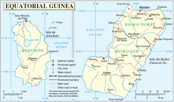
Equatorial Guinea
Equatorial Guinea, officially the Republic of Equatorial Guinea where the capital Malabo is situated.Annobón is the southernmost island of Equatorial Guinea and is situated just south of the equator. Bioko island is the northernmost point of Equatorial Guinea. Between the two islands and to the...
comprises the former Spanish territory of Fernando Poo
Bioko
Bioko is an island 32 km off the west coast of Africa, specifically Cameroon, in the Gulf of Guinea. It is the northernmost part of Equatorial Guinea with a population of 124,000 and an area of . It is volcanic with its highest peak the Pico Basile at .-Geography:Bioko has a total area of...
, together with Annobón
Annobón
Annobón may refer to:* Annobón Province* Annobonese language* Annobon people...
island, the latter formerly part of the Spanish territory of Elobey, Annobón and Corisco, which was located in the Gulf of Guinea
Gulf of Guinea
The Gulf of Guinea is the northeasternmost part of the tropical Atlantic Ocean between Cape Lopez in Gabon, north and west to Cape Palmas in Liberia. The intersection of the Equator and Prime Meridian is in the gulf....
and in the Corisco Bay.
The region covers 2,052 km² and has a population of about 265,000. It is split into three political jurisdictions:
- AnnobónAnnobón ProvinceAnnobón , also known as Pagalu or Pigalu, is an island of Equatorial Guinea. It is located in the South Atlantic Ocean at , about 220 miles west of Gabon and south west of São Tomé Island...
- Bioko NorteBioko Norte ProvinceBioko Norte Province is the most populated province of Equatorial Guinea. Its capital is Malabo. It occupies the northern part of the island of Bioko, the remainder of which comprises Bioko Sur Province....
- Bioko SurBioko Sur ProvinceBioko Sur Province is a province of Equatorial Guinea. Its capital is Luba. It occupies the southern part of the island of Bioko, the remnant of which comprises Bioko Norte Province....
.
- The islands located in the Corisco Bay are not part of the Insular Region but are included in the Litoral ProvinceLitoral Province (Equatorial Guinea)Litoral Province is a province of Equatorial Guinea. Its capital is Bata the other two cities are Mbini and Kogo. The Littoral Province has the largest population of Equatorial Guinea....
which is part of Continental RegionRío MuniRío Muni is the Continental Region of Equatorial Guinea, and comprises the mainland geographical region, covering 26,017 km².-History:Río Muni was ceded by Portugal to Spain in 1778 in the Treaty of El Pardo...
(Litoral ProvinceLitoral Province (Equatorial Guinea)Litoral Province is a province of Equatorial Guinea. Its capital is Bata the other two cities are Mbini and Kogo. The Littoral Province has the largest population of Equatorial Guinea....
).
The largest city and regional administrative capital is located in Malabo
Malabo
Malabo is the capital of Equatorial Guinea, located on the northern coast of Bioko Island on the rim of a sunken volcano....
. The other main cities are Luba
Luba
Luba may refer to:*Slavic origin feminine name which means "someone who has love"*Luba, Equatorial Guinea*Luba, Abra, a municipality in the Philippines*Ľubá, a village and municipality in the Nitra region of south-west Slovakia...
, Riaba
Riaba
Riaba is a town in Equatorial Guinea. It is also the 30th largest settlement in the country.-Location and population:It is located in Bioko Sur Province.It has a population of 1,071.-Road communications:...
, Rebola, Baney
Baney
Baney is a town in Equatorial Guinea. It is located in Bioko Norte Province and has a population of 2365....
, and San Antonio de Palé
San Antonio de Palé
San Antonio de Palé, is the capital of Annobón, an island in Equatorial Guinea that was once part of the Spanish Empire in Africa.A small town, it has only 600 inhabitants, the majority of whom speak the Annobonese creole. It is located in the extreme north of the island, which is the driest and...
.
Bioko
Bioko
Bioko is an island 32 km off the west coast of Africa, specifically Cameroon, in the Gulf of Guinea. It is the northernmost part of Equatorial Guinea with a population of 124,000 and an area of . It is volcanic with its highest peak the Pico Basile at .-Geography:Bioko has a total area of...
Bioko island is located about 40 km away from Cameroon
Cameroon
Cameroon, officially the Republic of Cameroon , is a country in west Central Africa. It is bordered by Nigeria to the west; Chad to the northeast; the Central African Republic to the east; and Equatorial Guinea, Gabon, and the Republic of the Congo to the south. Cameroon's coastline lies on the...
. Bioko has the nation's capital Malabo. Bioko island was known as "Fernando Poo" until the 70's, is also the largest island of the Gulf of Guinea
Gulf of Guinea
The Gulf of Guinea is the northeasternmost part of the tropical Atlantic Ocean between Cape Lopez in Gabon, north and west to Cape Palmas in Liberia. The intersection of the Equator and Prime Meridian is in the gulf....
, covering 2,017 km².
Annobón
Annobón
Annobón may refer to:* Annobón Province* Annobonese language* Annobon people...
With just 17 km², Annobón is the most remote territory of the Republic of Equatorial Guinea
Equatorial Guinea
Equatorial Guinea, officially the Republic of Equatorial Guinea where the capital Malabo is situated.Annobón is the southernmost island of Equatorial Guinea and is situated just south of the equator. Bioko island is the northernmost point of Equatorial Guinea. Between the two islands and to the...
, is a small volcanic island located 670 km away from Malabo and 580 km away from Bata, and in the other side of the equator
Equator
An equator is the intersection of a sphere's surface with the plane perpendicular to the sphere's axis of rotation and containing the sphere's center of mass....
. Between Annobón and Bioko are located the islands of São Tomé and Príncipe
São Tomé and Príncipe
São Tomé and Príncipe, officially the Democratic Republic of São Tomé and Príncipe, is a Portuguese-speaking island nation in the Gulf of Guinea, off the western equatorial coast of Central Africa. It consists of two islands: São Tomé and Príncipe, located about apart and about , respectively, off...
, Annobón is also the most remote island of the Gulf of Guinea.
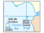
Corisco
Corisco, or Mandj, is a small island of Equatorial Guinea, located 29 km southwest of the Rio Muni estuary that defines the border with Gabon...
Corisco is located 25 km away from the Rio Muni estuary. Its surface is about 15 km² and has a population of 150. Corisco is the home of the Benga people, due the legendary beauty of the Benga women, for long time this island was known as "Isla del Amor" (Love island). Most of the inhabitants are "mestizos".
Elobey Grande
Elobey Grande
Elobey Grande or Great Elobey is an island of Equatorial Guinea, lying at the mouth of the Mitémélé River. It is sparsely inhabited. Elobey Chico is a smaller island offshore, now uninhabited but once the colonial capital of the Rio Muni....
and Elobey Chico
Elobey Chico
Elobey Chico or Little Elobey is a small island offshore the coast of Equatorial Guinea, lying near the mouth of the Mitémélé River. The island is now uninhabited but was once de facto colonial capital of the Spanish territory of Rio Muni....
Lying at the mouth of the Rio Muni. The surface of both islands is just about 2.46 km² and just 10 km away from Gabon
Gabon
Gabon , officially the Gabonese Republic is a state in west central Africa sharing borders with Equatorial Guinea to the northwest, Cameroon to the north, and with the Republic of the Congo curving around the east and south. The Gulf of Guinea, an arm of the Atlantic Ocean is to the west...
. "Elobey Grande" it is sparsely inhabited, the main settlement is the village of M’Belobi. "Elobey Chico" is a smaller island offshore, now uninhabited but once the colonial capital of the Rio Muni. Both Elobeys are part of the municipality of Corisco.