

Isla Navarino
Encyclopedia
Isla Navarino is a Chile
an island located strategically between Isla Grande de Tierra del Fuego
, to the north, and Cape Horn
, to the south. The island forms part of the Commune of Cabo de Hornos, the southernmost commune in Chile and in the world, belonging to Antártica Chilena Province
in the XII Region of Magallanes and Chilean Antarctica
. It constitutes the nearest land to the Antarctic continent. Its population is concentrated primarily in the communal capital, Puerto Williams
, and in small settlements like Puerto Navarino
and Puerto Toro
. The highest point of the island is Pico Navarino at 1195 meters.
archaeological site at Wulaia Bay, which C. Michael Hogan terms the Bahia Wulaia Dome Middens. Interest in the Yamana
or Yahgan culture attracts tourists, and there is a regional museum, the Martin Gusinde Anthropological Museum, where illustration of the Yaghan culture and the remains of the English missions can be seen. Aquatic birds, and the geology and botany of the island, also attract tourists.
 The scenic coast of Navarino Island offers opportunities for sea kayaking among small barren islands and channels surrounded by native vegetation and populated by a rich variety of birds.
There is fishing in the Murray Channel
. Boat trips can also be taken to visit the glaciers of the northwest arm of the Beagle Channel
(located in the Alberto de Agostini National Park
), and towards Cape Horn and Chilean Antarctica
.
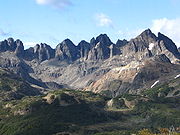
There is a five day hiking
circuit around the jagged pinnacles known as the Dientes de Navarino
. The trail passes peaks known as Cerro Clem and Montes Lindenmayer, named in 2001 by the Chilean Ministry of Natural Resources for the author of the Lonely Planet
guide. There are also areas for rock climbing.
There are several ranches, and the northern section of the island is suitable for horseback riding.
Salmon trout are found in abundance in Navarino Lake, and in the North coast of the island, the sea enters deep coves suitable for fishing snook.
. In the more southern areas annual precipitation increases to about 800 mm, with a slight diminution in temperatures. Precipitation is distributed more or less uniformly across the year, and some falls as snow. In the extensive southernmost part of the island, including Lakes Navarino and Windhond, there is an increase in precipitation, a diminution of summer temperatures and an increase in the winter temperatures by wind drift.
, whose characteristic species are Lenga Beech (Nothofagus pumilio), with Ñirre Beech (Nothofagus antarctica
) in the driest areas, Coihue of Magallanes
(Nothofagus betuloides) in the wettest areas and some shrublands and Magellanic moorland
in areas of poor drainage.
Immediately to the south is the evergreen Magellanic rainforest
, probably associated with the increased precipitation, the greater altitude and an improvement in the drainage. The characteristic species is Nothofagus betuloides (Coihue of Magallanes
), forming pure communities in sectors of greater altitude or coasts exposed to the wind.
The south portion of the island, surrounding Lakes Navarino and Windhond, and the territories of the southern coast, have a vegetation of Magellanic moorland
. This includes a series of vegetal communities, the Esfagnosa Tundra (Sphagnum magellanicum
) and the Pulvinada Tundra (Donatia fascicularis - Astelia pumilia).
At higher altitudes, the terrain is Andean Desert, which lacks trees or tall shrubs and is less than 30% covered by vegetation.
See Omora Ethnobotanical Park
.
 Cultural historical sites are Bahia Wulaia
and the English Mission of Douglas Creek. The large Stirling House, an iron Mecano construction brought in 1869 from England by the English missionaries
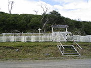
, previously was in Ushuaia and then in Tekenika Bay, being finally installed in Douglas Creek. In the Yahgan cemetery at Mejillones Bay, there are tombs, dating from the first half of the 20th century, which show elements of religious syncretism
.
Villa Ukika is a district of Puerto Williams where the few last Yamana
or Yahgan live. In Puerto Navarino
, a fishing port for king crabs, there are beautiful wooden buildings, mainly of the 1930s. Puerto Toro
is the world's southernmost settlement.
There is skiing in Cerro La Bandera, near Puerto Williams.
Whales and orcas can be seen in Windhond Bay. The area of Isla Navarino and the surrounding islands have been declared a UNESCO
Biosphere Reserve
in June 2005, called Cabo de Hornos Biosphere Reserve.
, daily except Sundays. In addition there is a weekly a ferry, crossing the Strait of Magellan
and the Brecknock, Cockburn and Beagle Channels. The boat trip takes between 30 and 36 hours. As of January 2011, there was also a commercial connection by motorboat between Ushuaia and Isla Navarino.
Chile
Chile ,officially the Republic of Chile , is a country in South America occupying a long, narrow coastal strip between the Andes mountains to the east and the Pacific Ocean to the west. It borders Peru to the north, Bolivia to the northeast, Argentina to the east, and the Drake Passage in the far...
an island located strategically between Isla Grande de Tierra del Fuego
Isla Grande de Tierra del Fuego
Isla Grande de Tierra del Fuego is an island near the southern tip of South America from which it is separated by the Strait of Magellan...
, to the north, and Cape Horn
Cape Horn
Cape Horn is the southernmost headland of the Tierra del Fuego archipelago of southern Chile, and is located on the small Hornos Island...
, to the south. The island forms part of the Commune of Cabo de Hornos, the southernmost commune in Chile and in the world, belonging to Antártica Chilena Province
Antártica Chilena Province
Antártica Chilena Province is the southernmost and one of four provinces in Chile's southernmost region, Magallanes and Antártica Chilena Region . The capital is Puerto Williams...
in the XII Region of Magallanes and Chilean Antarctica
Magallanes y la Antártica Chilena Region
The XII Magallanes and Antártica Chilena Region is one of Chile's 15 first order administrative divisions...
. It constitutes the nearest land to the Antarctic continent. Its population is concentrated primarily in the communal capital, Puerto Williams
Puerto Williams
Puerto Williams is a Chilean port, located on Isla Navarino facing the Beagle Channel. It is the capital of the Chilean Antarctic Province, one of four provinces located in the Magellan and Chilean Antartica Region...
, and in small settlements like Puerto Navarino
Puerto Navarino
Puerto Navarino is a Chilean port facing the Beagle Channel in western Navarino Island. Puerto Navarino belongs to Cabo de Hornos commune and is connected to Puerto Williams by a gravel road.-External links:***...
and Puerto Toro
Puerto Toro
Puerto Toro, founded 1892 by Governor of Punta Arenas Señoret is a hamlet on the eastern coast of Navarino Island, Chile.It belongs to the Commune of Cabo de Hornos, in Antártica Chilena Province of Magallanes y Antártica Chilena Region...
. The highest point of the island is Pico Navarino at 1195 meters.
Historical background
History and archaeology may be the most valuable resource of Navarino Island and its adjacent sectors. There is a significant YaghanYaghan
The Yaghan, also called Yagán, Yahgan , Yámana or Yamana, are the indigenous inhabitants of the islands south of Isla Grande de Tierra del Fuego extending their presence into Cape Horn...
archaeological site at Wulaia Bay, which C. Michael Hogan terms the Bahia Wulaia Dome Middens. Interest in the Yamana
Yamana
Yamana may mean:* Yámana, an alternate name for the Yaghan language and people, in Chile and Argentina* Yamana clan, a Japanese clan * Yamana Gold Inc., a Canadian-based gold mining company operating in South and Central America...
or Yahgan culture attracts tourists, and there is a regional museum, the Martin Gusinde Anthropological Museum, where illustration of the Yaghan culture and the remains of the English missions can be seen. Aquatic birds, and the geology and botany of the island, also attract tourists.
Features
There is fishing in the Murray Channel
Murray Channel
The Murray Channel is a channel of Chile located in the Commune of Cabo de Hornos, in the Antártica Chilena Province of the Magallanes y la Antártica Chilena Region. It separates Hoste Island from Navarino Island and is bounded by the Beagle Channel to the north...
. Boat trips can also be taken to visit the glaciers of the northwest arm of the Beagle Channel
Beagle Channel
thumb|right|300px|Aereal view of Beagle Channel. The Chilean [[Navarino Island]] is seen in the top-right while the Argentine part of [[Isla Grande de Tierra del Fuego]] is seen at the bottom-left....
(located in the Alberto de Agostini National Park
Alberto de Agostini National Park
Alberto de Agostini National Park is a park located in the Chilean part of Tierra del Fuego. It covers and includes the Cordillera Darwin mountain range. The park is named after Alberto Maria De Agostini, who was an Italian missionary and explorer. Several tidewater glaciers and steep fjords form...
), and towards Cape Horn and Chilean Antarctica
Antártica Chilena Province
Antártica Chilena Province is the southernmost and one of four provinces in Chile's southernmost region, Magallanes and Antártica Chilena Region . The capital is Puerto Williams...
.
There is a five day hiking
Hiking
Hiking is an outdoor activity which consists of walking in natural environments, often in mountainous or other scenic terrain. People often hike on hiking trails. It is such a popular activity that there are numerous hiking organizations worldwide. The health benefits of different types of hiking...
circuit around the jagged pinnacles known as the Dientes de Navarino
Dientes de Navarino
Dientes de Navarino are a mountain range in Navarino Island located just south of Puerto Williams, along the Beagle Channel coast....
. The trail passes peaks known as Cerro Clem and Montes Lindenmayer, named in 2001 by the Chilean Ministry of Natural Resources for the author of the Lonely Planet
Lonely Planet
Lonely Planet is the largest travel guide book and digital media publisher in the world. The company is owned by BBC Worldwide, which bought a 75% share from the founders Maureen and Tony Wheeler in 2007 and the final 25% in February 2011...
guide. There are also areas for rock climbing.
There are several ranches, and the northern section of the island is suitable for horseback riding.
Salmon trout are found in abundance in Navarino Lake, and in the North coast of the island, the sea enters deep coves suitable for fishing snook.
Climate
In the northern coastal strip, where Puerto Williams is, the annual average precipitation is 467 mm., with a temperature of 6°C. The average temperature in the warmest month is 9.6°C, and in the coldest month 1.9°C., which is similar to the climate of UshuaiaUshuaia
Ushuaia may refer to the following:*Ushuaia, a city in Argentina.**Ushuaia Department, an administrative division**Ushuaia River**Ushuaia International Airport**Colegio Nacional de Ushuaia, National School of Ushuaia....
. In the more southern areas annual precipitation increases to about 800 mm, with a slight diminution in temperatures. Precipitation is distributed more or less uniformly across the year, and some falls as snow. In the extensive southernmost part of the island, including Lakes Navarino and Windhond, there is an increase in precipitation, a diminution of summer temperatures and an increase in the winter temperatures by wind drift.
Flora
In the North end of the island the vegetation is characterized by the deciduous Magellanic forestMagellanic subpolar forests
The Magellanic subpolar forests are a terrestrial ecoregion of southernmost South America, covering parts of southern Chile and Argentina, and is part of the Neotropic ecozone...
, whose characteristic species are Lenga Beech (Nothofagus pumilio), with Ñirre Beech (Nothofagus antarctica
Nothofagus antarctica
Nothofagus antarctica , is a deciduous tree or shrub native to southern Chile and Argentina from about 36°S to Tierra del Fuego . The southernmost occurrence is on Hoste Island, making it the southernmost trees on earth...
) in the driest areas, Coihue of Magallanes
Coihue
Nothofagus dombeyi is a tree species native to southern Chile and the Andean parts of Argentine Patagonia. It grows from 35 to 45° South latitude between 700 and 1,200 m above mean sea level. It forms dense forests, like those found in the Los Alerces and Nahuel Huapi national parks...
(Nothofagus betuloides) in the wettest areas and some shrublands and Magellanic moorland
Magellanic subpolar forests
The Magellanic subpolar forests are a terrestrial ecoregion of southernmost South America, covering parts of southern Chile and Argentina, and is part of the Neotropic ecozone...
in areas of poor drainage.
Immediately to the south is the evergreen Magellanic rainforest
Magellanic subpolar forests
The Magellanic subpolar forests are a terrestrial ecoregion of southernmost South America, covering parts of southern Chile and Argentina, and is part of the Neotropic ecozone...
, probably associated with the increased precipitation, the greater altitude and an improvement in the drainage. The characteristic species is Nothofagus betuloides (Coihue of Magallanes
Coihue
Nothofagus dombeyi is a tree species native to southern Chile and the Andean parts of Argentine Patagonia. It grows from 35 to 45° South latitude between 700 and 1,200 m above mean sea level. It forms dense forests, like those found in the Los Alerces and Nahuel Huapi national parks...
), forming pure communities in sectors of greater altitude or coasts exposed to the wind.
The south portion of the island, surrounding Lakes Navarino and Windhond, and the territories of the southern coast, have a vegetation of Magellanic moorland
Magellanic subpolar forests
The Magellanic subpolar forests are a terrestrial ecoregion of southernmost South America, covering parts of southern Chile and Argentina, and is part of the Neotropic ecozone...
. This includes a series of vegetal communities, the Esfagnosa Tundra (Sphagnum magellanicum
Sphagnum magellanicum
Sphagnum magellanicum is one of the most common species of mosses in Chile. It has a distinctive reddish colour which makes it easy to recognise among other sphagnum species in Chile....
) and the Pulvinada Tundra (Donatia fascicularis - Astelia pumilia).
At higher altitudes, the terrain is Andean Desert, which lacks trees or tall shrubs and is less than 30% covered by vegetation.
See Omora Ethnobotanical Park
Omora Ethnobotanical Park
Omora Ethnobotanical Park is a protected area of Chile located west of Puerto Williams on Navarino Island in the extreme southern Magellan and Chilean Antarctica Region. The Omora Park is a research, education and conservation center for the Cape Horn Biosphere Reserve...
.
Natural and Cultural Features
Bahia Wulaia
Bahia Wulaia is a bay on the western shore of Isla Navarino along the Murray Channel in extreme southern Chile. The island and adjacent strait are part of the commune of Cabo de Hornos in the Antártica Chilena Province, which is part of the Magallanes and Antartica Chilena Region. There is an...
and the English Mission of Douglas Creek. The large Stirling House, an iron Mecano construction brought in 1869 from England by the English missionaries
South American Missionary Society
The South American Mission Society was founded at Brighton in 1844 as the Patagonian Mission. Captain Allen Gardiner, R.N., was the first secretary. The name "Patagonian Mission" was retained for twenty years, when the new title was adopted...
, previously was in Ushuaia and then in Tekenika Bay, being finally installed in Douglas Creek. In the Yahgan cemetery at Mejillones Bay, there are tombs, dating from the first half of the 20th century, which show elements of religious syncretism
Syncretism
Syncretism is the combining of different beliefs, often while melding practices of various schools of thought. The term means "combining", but see below for the origin of the word...
.
Villa Ukika is a district of Puerto Williams where the few last Yamana
Yamana
Yamana may mean:* Yámana, an alternate name for the Yaghan language and people, in Chile and Argentina* Yamana clan, a Japanese clan * Yamana Gold Inc., a Canadian-based gold mining company operating in South and Central America...
or Yahgan live. In Puerto Navarino
Puerto Navarino
Puerto Navarino is a Chilean port facing the Beagle Channel in western Navarino Island. Puerto Navarino belongs to Cabo de Hornos commune and is connected to Puerto Williams by a gravel road.-External links:***...
, a fishing port for king crabs, there are beautiful wooden buildings, mainly of the 1930s. Puerto Toro
Puerto Toro
Puerto Toro, founded 1892 by Governor of Punta Arenas Señoret is a hamlet on the eastern coast of Navarino Island, Chile.It belongs to the Commune of Cabo de Hornos, in Antártica Chilena Province of Magallanes y Antártica Chilena Region...
is the world's southernmost settlement.
There is skiing in Cerro La Bandera, near Puerto Williams.
Whales and orcas can be seen in Windhond Bay. The area of Isla Navarino and the surrounding islands have been declared a UNESCO
UNESCO
The United Nations Educational, Scientific and Cultural Organization is a specialized agency of the United Nations...
Biosphere Reserve
Biosphere reserve
The Man and the Biosphere Programme of UNESCO was established in 1971 to promote interdisciplinary approaches to management, research and education in ecosystem conservation and sustainable use of natural resources.-Development:...
in June 2005, called Cabo de Hornos Biosphere Reserve.
Access
Puerto Williams can be reached by air from Punta Arenas, by DAPDAP
Dap or DAP may refer to:*Dap greeting, a form of greeting in which two people slap and grasp hands briefly; also called a 'fist bump'*Delivered at Place, one of the rules defined by Incoterms 2010 for general modes of transportation...
, daily except Sundays. In addition there is a weekly a ferry, crossing the Strait of Magellan
Strait of Magellan
The Strait of Magellan comprises a navigable sea route immediately south of mainland South America and north of Tierra del Fuego...
and the Brecknock, Cockburn and Beagle Channels. The boat trip takes between 30 and 36 hours. As of January 2011, there was also a commercial connection by motorboat between Ushuaia and Isla Navarino.
Towns and Villages
- Puerto Bevan
- Puerto WilliamsPuerto WilliamsPuerto Williams is a Chilean port, located on Isla Navarino facing the Beagle Channel. It is the capital of the Chilean Antarctic Province, one of four provinces located in the Magellan and Chilean Antartica Region...
- Puerto NavarinoPuerto NavarinoPuerto Navarino is a Chilean port facing the Beagle Channel in western Navarino Island. Puerto Navarino belongs to Cabo de Hornos commune and is connected to Puerto Williams by a gravel road.-External links:***...
- Caleta Eugenia
- Puerto ToroPuerto ToroPuerto Toro, founded 1892 by Governor of Punta Arenas Señoret is a hamlet on the eastern coast of Navarino Island, Chile.It belongs to the Commune of Cabo de Hornos, in Antártica Chilena Province of Magallanes y Antártica Chilena Region...
- Villa Ukika