
Isla Aves
Encyclopedia
Isla de Aves or Aves Island, is a Caribbean dependency
of Venezuela
. It has been the subject of numerous territorial dispute
s between the neighboring independent islands, such as Dominica
, and European mother countries of surrounding dependent islands, such as the Netherlands
. It lies to the west of the Leeward Islands
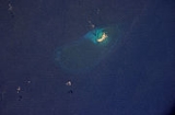
chain at 15°40′18"N 63°36′59"W. It is 375 m in length and never more than 50 m in width, and rises 4 m above the sea on a calm day. According to the UN Law of the Seas
it is classified as a rock, which would only give Venezuela a twelve mile economic zone. However, Venezuela claims it is an island which grants it a 200 mile Exclusive Economic Zone. Mostly sand, a small portion has some scrubby vegetation. It is sometimes completely submerged during hurricanes. It is 115 miles southwest of the closest land, Montserrat
, 140 miles west of Dominica
and 340 miles north of the Venezuelan mainland.
For some time the island has been in danger of eroding altogether, and Venezuelan authorities are considering ways to protect it, along with the territorial claims to the Caribbean Sea
which radiate from Isla Aves. The impact of Hurricane Allen
in the 1980 Atlantic hurricane season
divided it into two parts, but accretions of coral
have subsequently reunited it. On August 17, 2007, the force of Hurricane Dean
severely eroded the island.
The island is a resting and breeding place for seabirds and the Green Sea Turtle
(Chelonia mydas). Its low profile makes it a hazard to navigation, and many ships have been wrecked here.
Aves Island is a particularly rare amateur radio
"entity", under the ITU prefix YV0. A 2006 expedition by operators to the island required 14 years of planning. Though one member suffered a fatal heart attack, over 42,000 contacts were made during their week-long stay.
, Spain
, Portugal
and the Netherlands
. Throughout the 17th, 18th and 19th centuries, the inhabitants of the Dutch
islands St. Eustatius and Saba regularly visited Aves to collect turtle and bird eggs.
In 1678, the entire fleet of 17 vessels under the command of Comte d'Estrées
was wrecked on the Aves reefs beyond a planned raid on the Dutch island of Curaçao
.
In 1854 a US captain discovered the abundant quantities of guano
on Aves and systematic collection started not long after. Both the Dutch and Venezuelan authorities found out and protested. The Dutch sent a warship to Aves. Its captain found Americans loading guano. He informed them that the Dutch considered Aves to belong to the Netherlands.
The Dutch authorities on Curaçao
, under whom St. Eustatius and Saba fell, sat down with the Venezuelans and together decided to find a mutually acceptable sovereign to decide about the ownership of Aves Island. The Queen of Spain
was accepted by both parties, and in 1865 Isabella II ruled on the issue, deciding in favor of the Spanish speaking heirs of her ancestors' empire.
However, Isabella's judgment acknowledged the time honored rights of the inhabitants of the Dutch islands St. Eustatius, Saba and St. Maarten to fish in the waters around Aves. As this was the main issue the Dutch had, they accepted the ruling. Later, some Dutch historians argued that Isabella's advisors could have mixed up Aves with Las Aves Archipelago
lying between Bonaire and Los Roques, just off the coast of Venezuela.
In the meantime, in 1859 the Administrator of St. Eustatius granted a concession to collect guano on Aves to ‘Edward Green, Kean & Co.’ in Baltimore at f. 2.50 per ton. He decided that “even though Aves was never permanently settled by the Dutch, the inhabitants of Statia and Saba had made use of the island longer than anyone can remember,” which “constituted proof of possession.” He gave a provisionary concession and asked the Governor in Curaçao to confirm. The Governor, meanwhile, had received a request to mine guano on Aves from a group of business men on Dutch St. Maarten, “who had assured themselves that Aves was recognized as a possession of the Dutch government.”
From 1878 to 1912 the island was again occupied by American guano
miners until supplies were eventually exhausted.
Isla de Aves was included in Venezuela's territorial reorganization done by President Joaquin Crespo
in 1895. By 1905, Isla de Aves was a municipality called "Municipio Oriental" part of Colon Federal Territory.
In 1950, a Venezuelan Navy fleet consisting of two patrol boats and one transport boat were sent to take control of the island with a group of soldiers. On June 2, 1978, the Venezuelan Navy were sent to set up a scientific naval base named Simón Bolívar
on the lee (west) side near the southern tip of the island, constructed as a platform built on stilts partially in the water, which was permanently inhabited by a group of scientists and military personnel.
On March 28, 1978, Venezuela, using Aves Island as its reference, agreed its maritime borders
with the USA between Aves Island and Puerto Rico in the United States – Venezuela Maritime Boundary Treaty
; this treaty came into force on 24 November 1980 after it was ratified by both parties. On June 17, 1980, Venezuela agreed with France that longitude 62D 48M 52S W should be the maritime boundary
between Aves Island and Guadeloupe and Martinique.
During a visit to Venezuela, Dominica Prime Minister Roosevelt Skerrit
, in June 2006, stated that Aves Island belongs to Venezuela, ending the territorial claim but not a maritime claim.
Caribbean Sea
The Caribbean Sea is a sea of the Atlantic Ocean located in the tropics of the Western hemisphere. It is bounded by Mexico and Central America to the west and southwest, to the north by the Greater Antilles, and to the east by the Lesser Antilles....
of Venezuela
Venezuela
Venezuela , officially called the Bolivarian Republic of Venezuela , is a tropical country on the northern coast of South America. It borders Colombia to the west, Guyana to the east, and Brazil to the south...
. It has been the subject of numerous territorial dispute
Territorial dispute
A territorial dispute is a disagreement over the possession/control of land between two or more states or over the possession or control of land by a new state and occupying power after it has conquered the land from a former state no longer currently recognized by the new state.-Context and...
s between the neighboring independent islands, such as Dominica
Dominica
Dominica , officially the Commonwealth of Dominica, is an island nation in the Lesser Antilles region of the Caribbean Sea, south-southeast of Guadeloupe and northwest of Martinique. Its size is and the highest point in the country is Morne Diablotins, which has an elevation of . The Commonwealth...
, and European mother countries of surrounding dependent islands, such as the Netherlands
Netherlands
The Netherlands is a constituent country of the Kingdom of the Netherlands, located mainly in North-West Europe and with several islands in the Caribbean. Mainland Netherlands borders the North Sea to the north and west, Belgium to the south, and Germany to the east, and shares maritime borders...
. It lies to the west of the Leeward Islands
Leeward Islands
The Leeward Islands are a group of islands in the West Indies. They are the northern islands of the Lesser Antilles chain. As a group they start east of Puerto Rico and reach southward to Dominica. They are situated where the northeastern Caribbean Sea meets the western Atlantic Ocean...
chain at 15°40′18"N 63°36′59"W. It is 375 m in length and never more than 50 m in width, and rises 4 m above the sea on a calm day. According to the UN Law of the Seas
United Nations Convention on the Law of the Sea
The United Nations Convention on the Law of the Sea , also called the Law of the Sea Convention or the Law of the Sea treaty, is the international agreement that resulted from the third United Nations Conference on the Law of the Sea , which took place from 1973 through 1982...
it is classified as a rock, which would only give Venezuela a twelve mile economic zone. However, Venezuela claims it is an island which grants it a 200 mile Exclusive Economic Zone. Mostly sand, a small portion has some scrubby vegetation. It is sometimes completely submerged during hurricanes. It is 115 miles southwest of the closest land, Montserrat
Montserrat
Montserrat is a British overseas territory located in the Leeward Islands, part of the chain of islands called the Lesser Antilles in the West Indies. This island measures approximately long and wide, giving of coastline...
, 140 miles west of Dominica
Dominica
Dominica , officially the Commonwealth of Dominica, is an island nation in the Lesser Antilles region of the Caribbean Sea, south-southeast of Guadeloupe and northwest of Martinique. Its size is and the highest point in the country is Morne Diablotins, which has an elevation of . The Commonwealth...
and 340 miles north of the Venezuelan mainland.
For some time the island has been in danger of eroding altogether, and Venezuelan authorities are considering ways to protect it, along with the territorial claims to the Caribbean Sea
Caribbean Sea
The Caribbean Sea is a sea of the Atlantic Ocean located in the tropics of the Western hemisphere. It is bounded by Mexico and Central America to the west and southwest, to the north by the Greater Antilles, and to the east by the Lesser Antilles....
which radiate from Isla Aves. The impact of Hurricane Allen
Hurricane Allen
Hurricane Allen was the first and strongest hurricane of the 1980 Atlantic hurricane season. It was one of the strongest hurricanes in recorded history, one of the few hurricanes to reach Category 5 status on the Saffir-Simpson Hurricane Scale on three separate occasions, and spent more time...
in the 1980 Atlantic hurricane season
1980 Atlantic hurricane season
The 1980 Atlantic hurricane season officially began on June 1, 1980, and lasted until November 30, 1980. These dates conventionally delimit the period of each year when most tropical cyclones form in the Atlantic basin. The season was fairly active, with eleven storms forming, of which nine reached...
divided it into two parts, but accretions of coral
Coral
Corals are marine animals in class Anthozoa of phylum Cnidaria typically living in compact colonies of many identical individual "polyps". The group includes the important reef builders that inhabit tropical oceans and secrete calcium carbonate to form a hard skeleton.A coral "head" is a colony of...
have subsequently reunited it. On August 17, 2007, the force of Hurricane Dean
Hurricane Dean
The name Dean was used for five tropical cyclones in the Northern Atlantic Ocean:*1983's Tropical Storm Dean, which struck the coast of Virginia, causing minor erosion and flooding...
severely eroded the island.
The island is a resting and breeding place for seabirds and the Green Sea Turtle
Green Sea Turtle
The Green sea turtle or green turtle is a large sea turtle of the family Cheloniidae. It is the only species in the genus Chelonia. Its range extends throughout tropical and subtropical seas around the world, with two distinct populations in the Atlantic and Pacific Oceans...
(Chelonia mydas). Its low profile makes it a hazard to navigation, and many ships have been wrecked here.
Aves Island is a particularly rare amateur radio
Amateur radio
Amateur radio is the use of designated radio frequency spectrum for purposes of private recreation, non-commercial exchange of messages, wireless experimentation, self-training, and emergency communication...
"entity", under the ITU prefix YV0. A 2006 expedition by operators to the island required 14 years of planning. Though one member suffered a fatal heart attack, over 42,000 contacts were made during their week-long stay.
History
The island was most likely discovered by Avaro Sanzze in 1584, though it was not settled. It was subsequently claimed for Great BritainKingdom of Great Britain
The former Kingdom of Great Britain, sometimes described as the 'United Kingdom of Great Britain', That the Two Kingdoms of Scotland and England, shall upon the 1st May next ensuing the date hereof, and forever after, be United into One Kingdom by the Name of GREAT BRITAIN. was a sovereign...
, Spain
Spain
Spain , officially the Kingdom of Spain languages]] under the European Charter for Regional or Minority Languages. In each of these, Spain's official name is as follows:;;;;;;), is a country and member state of the European Union located in southwestern Europe on the Iberian Peninsula...
, Portugal
Portugal
Portugal , officially the Portuguese Republic is a country situated in southwestern Europe on the Iberian Peninsula. Portugal is the westernmost country of Europe, and is bordered by the Atlantic Ocean to the West and South and by Spain to the North and East. The Atlantic archipelagos of the...
and the Netherlands
Netherlands
The Netherlands is a constituent country of the Kingdom of the Netherlands, located mainly in North-West Europe and with several islands in the Caribbean. Mainland Netherlands borders the North Sea to the north and west, Belgium to the south, and Germany to the east, and shares maritime borders...
. Throughout the 17th, 18th and 19th centuries, the inhabitants of the Dutch
Netherlands
The Netherlands is a constituent country of the Kingdom of the Netherlands, located mainly in North-West Europe and with several islands in the Caribbean. Mainland Netherlands borders the North Sea to the north and west, Belgium to the south, and Germany to the east, and shares maritime borders...
islands St. Eustatius and Saba regularly visited Aves to collect turtle and bird eggs.
In 1678, the entire fleet of 17 vessels under the command of Comte d'Estrées
Jean II d'Estrées
Jean II d'Estrées, , was a Marshal of France, and an important naval commander of Louis XIV.Jean d'Estrées was born in a noble family from Picardie...
was wrecked on the Aves reefs beyond a planned raid on the Dutch island of Curaçao
Curaçao
Curaçao is an island in the southern Caribbean Sea, off the Venezuelan coast. The Country of Curaçao , which includes the main island plus the small, uninhabited island of Klein Curaçao , is a constituent country of the Kingdom of the Netherlands...
.
In 1854 a US captain discovered the abundant quantities of guano
Guano
Guano is the excrement of seabirds, cave dwelling bats, and seals. Guano manure is an effective fertilizer due to its high levels of phosphorus and nitrogen and also its lack of odor. It was an important source of nitrates for gunpowder...
on Aves and systematic collection started not long after. Both the Dutch and Venezuelan authorities found out and protested. The Dutch sent a warship to Aves. Its captain found Americans loading guano. He informed them that the Dutch considered Aves to belong to the Netherlands.
The Dutch authorities on Curaçao
Curaçao
Curaçao is an island in the southern Caribbean Sea, off the Venezuelan coast. The Country of Curaçao , which includes the main island plus the small, uninhabited island of Klein Curaçao , is a constituent country of the Kingdom of the Netherlands...
, under whom St. Eustatius and Saba fell, sat down with the Venezuelans and together decided to find a mutually acceptable sovereign to decide about the ownership of Aves Island. The Queen of Spain
Spain
Spain , officially the Kingdom of Spain languages]] under the European Charter for Regional or Minority Languages. In each of these, Spain's official name is as follows:;;;;;;), is a country and member state of the European Union located in southwestern Europe on the Iberian Peninsula...
was accepted by both parties, and in 1865 Isabella II ruled on the issue, deciding in favor of the Spanish speaking heirs of her ancestors' empire.
However, Isabella's judgment acknowledged the time honored rights of the inhabitants of the Dutch islands St. Eustatius, Saba and St. Maarten to fish in the waters around Aves. As this was the main issue the Dutch had, they accepted the ruling. Later, some Dutch historians argued that Isabella's advisors could have mixed up Aves with Las Aves Archipelago
Las Aves Archipelago
The Las Aves Archipelagois a pristine archipelago in the Caribbean Sea, and is part of the Federal Dependencies of Venezuela. It is located north of the Venezuelan states of Aragua and Carabobo, between the Dutch island Bonaire in the west, and the Los Roques Archipelago in the east, at . The prime...
lying between Bonaire and Los Roques, just off the coast of Venezuela.
In the meantime, in 1859 the Administrator of St. Eustatius granted a concession to collect guano on Aves to ‘Edward Green, Kean & Co.’ in Baltimore at f. 2.50 per ton. He decided that “even though Aves was never permanently settled by the Dutch, the inhabitants of Statia and Saba had made use of the island longer than anyone can remember,” which “constituted proof of possession.” He gave a provisionary concession and asked the Governor in Curaçao to confirm. The Governor, meanwhile, had received a request to mine guano on Aves from a group of business men on Dutch St. Maarten, “who had assured themselves that Aves was recognized as a possession of the Dutch government.”
From 1878 to 1912 the island was again occupied by American guano
Guano
Guano is the excrement of seabirds, cave dwelling bats, and seals. Guano manure is an effective fertilizer due to its high levels of phosphorus and nitrogen and also its lack of odor. It was an important source of nitrates for gunpowder...
miners until supplies were eventually exhausted.
Isla de Aves was included in Venezuela's territorial reorganization done by President Joaquin Crespo
Joaquín Crespo
Joaquín Sinforiano de Jesús Crespo Torres was a politician, soldier, a member of the Great Liberal Party of Venezuela and President of Venezuela from 1884 to 1886 and again from 1892 to 1898...
in 1895. By 1905, Isla de Aves was a municipality called "Municipio Oriental" part of Colon Federal Territory.
In 1950, a Venezuelan Navy fleet consisting of two patrol boats and one transport boat were sent to take control of the island with a group of soldiers. On June 2, 1978, the Venezuelan Navy were sent to set up a scientific naval base named Simón Bolívar
Simón Bolívar
Simón José Antonio de la Santísima Trinidad Bolívar y Palacios Ponte y Yeiter, commonly known as Simón Bolívar was a Venezuelan military and political leader...
on the lee (west) side near the southern tip of the island, constructed as a platform built on stilts partially in the water, which was permanently inhabited by a group of scientists and military personnel.
On March 28, 1978, Venezuela, using Aves Island as its reference, agreed its maritime borders
Maritime boundary
Maritime boundary is a conceptual means of division of the water surface of the planet into maritime areas that are defined through surrounding physical geography or by human geography. As such it usually includes areas of exclusive national rights over the mineral and biological resources,...
with the USA between Aves Island and Puerto Rico in the United States – Venezuela Maritime Boundary Treaty
United States – Venezuela Maritime Boundary Treaty
The United States – Venezuela Maritime Boundary Treaty is a 1978 treaty between the United States and Venezuela which delimits the maritime boundary between Venezuelan islands in the Caribbean Sea and the American territories of Puerto Rico and the Virgin Islands.The treaty was signed in Caracas on...
; this treaty came into force on 24 November 1980 after it was ratified by both parties. On June 17, 1980, Venezuela agreed with France that longitude 62D 48M 52S W should be the maritime boundary
Maritime boundary
Maritime boundary is a conceptual means of division of the water surface of the planet into maritime areas that are defined through surrounding physical geography or by human geography. As such it usually includes areas of exclusive national rights over the mineral and biological resources,...
between Aves Island and Guadeloupe and Martinique.
During a visit to Venezuela, Dominica Prime Minister Roosevelt Skerrit
Roosevelt Skerrit
Roosevelt Skerrit is a Dominican politician who has been Prime Minister of Dominica since 2004; he has also been the Member of Parliament for the Vieille Case constituency since 2000...
, in June 2006, stated that Aves Island belongs to Venezuela, ending the territorial claim but not a maritime claim.
See also
- Ankoko IslandAnkoko IslandAnkoko Island is located at the confluence of the Cuyuni River and Wenamu River, at , on the border between Venezuela and the disputed area of Guayana Esequiba, Guyana....
(Another disputed territory involving Venezuela) - Exclusive Economic ZoneExclusive Economic ZoneUnder the law of the sea, an exclusive economic zone is a seazone over which a state has special rights over the exploration and use of marine resources, including production of energy from water and wind. It stretches from the seaward edge of the state's territorial sea out to 200 nautical...
External links
- Information about the island
- Official Communique from the CARICOM heads of government– Subheader OECS-Venezuela
- Bird Island: time to act - Editorial on the Commonwealth of Dominica taking steps to reclaim sovereignty over the island.
- Aves Island a Strategic Island in the Caribbean Sea - by Thomson Fontaine - Should Dominica Stake a Claim to the Island? (The Dominican, October 21, 2002)
- 2006 amateur radio activity, including pictures
- NASA Earth Observatory
Articles and papers
- "Island' talk for Caricom, Venezuela - (July 7, 2006) - Barbados NationNews
- OECS searching for Bird Island solution - (March 16, 2006) - Caribbean Net News
- Shock over Bird Island - (November 10, 2005) - Barbados Advocate News
- Drama over Bird Island (November 10, 2005) - Barbados Advocate News
- OECS raps Caracas' claim to island (November 9, 2005) - Barbados NationNews
- Caricom to meet over Aves Island (October 24, 2005) - Barbados NationNews
- History proves Venezuelan ownership of Isla de Aves
- VicePresident Rangel thinks that the "empire" is behind claim to Aves Island