
Interstate 89
Encyclopedia
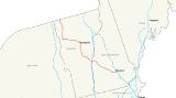
Interstate 89 is an interstate highway in the New England
region of the United States
travelling between Bow, New Hampshire
and Highgate Springs, Vermont. As with all odd-numbered primary interstates, I-89 is signed as a north–south highway. However, the northwest-to-southeast path the road actually takes, serves in two capacities: as an east–west interstate highway north of Interstate 90
in New England, and as a substantial part of the main connection between the major cities of Montreal
and Boston
. The largest cities directly served by I-89 are Concord, New Hampshire
and Burlington, Vermont
. I-89 is one of three Interstate highways whose entire route is located within the New England states.
Interstate 89 connects smaller cities and rural areas within New Hampshire and Vermont, and maintains two lanes of traffic in each direction throughout the route. Unlike its neighboring Interstates (91
and 93
), it does not intersect any even-numbered Interstates along its route. It does, however, parallel (and interchange multiple times with) portions of three U.S. routes: U.S. Route 4
from Enfield
to White River Junction
; U.S. Route 2
from Montpelier
to Colchester
, and U.S. Route 7
from Burlington
to the Canadian border.
|NH
|| 60.80 || 97.89
|-
|VT
|| 130.25 || 209.70
|-
|Total || 191.05 || 307.59
|}
, at its southern terminus, and Lebanon
, on the Vermont border. Mileage signs along I-89 in each direction consistently list one of the two cities. Also located along I-89 in New Hampshire are the towns of Grantham
, New London
and Warner
.
Starting at an intersection with Interstate 93
and New Hampshire Route 3A
in the town of Bow
, just south of the New Hampshire
capital city of Concord
, the highway runs a northwest path through the Dartmouth-Lake Sunapee Region
. One exit directly serves Concord (Exit 2) before the highway enters the neighboring town of Hopkinton
. east–west New Hampshire Route 11
joins I-89 at Exit 11 and runs concurrently with it for about 3 miles (4.8 km) before departing at Exit 12. At Exit 13 in Grantham
, New Hampshire Route 10
enters I-89, and the pair of highways form another concurrency, this one for about 15 miles (24.1 km). Guide signs for exit 16 southeast of Lebanon
display the name "Purmort", a made-up name taken from the name of an early settler in order to meet naming conventions for interstate exits. However, a community by that name has now taken root around the exit.
The highway continues northwest, passing through Lebanon, in which the Dartmouth-Hitchcock Medical Center
is located. A few miles north of this point is Dartmouth College
. U.S. Route 4
parallels I-89 through Lebanon. Exits 17-20 serve the city of Lebanon and are passed in quick succession. At Exit 19, northbound New Hampshire Route 10
separates from I-89 and joins westbound U.S. Route 4
to pass through West Lebanon
. The final exit in New Hampshire is Exit 20, providing access to West Lebanon's large retail district along New Hampshire Route 12A. Just after this interchange, the highway crosses the Connecticut River
and enters Vermont
, where it remains for the rest of its run northwest to the Canadian border.
 Interstate 89 is one of Vermont's most important roads, as it is the only Interstate highway to directly serve both Vermont's capital city (Montpelier
) and largest city (Burlington
). Other important cities and towns located along I-89 are Barre, Waterbury
, and St. Albans
. Williston
, which has become Burlington's big-box retail center (and one of the fastest-growing towns in the state) over the past decade, also has an interchange along I-89.
Crossing the Connecticut River
into Vermont, I-89 continues the northwesterly direction it carried in New Hampshire. The Interstate intersects I-91
at an unnumbered interchange immediately upon entering Vermont. Shortly afterward, another interchange with U.S. 4
occurs. The highway begins to enter the scenic rolling hills of Vermont, turning almost due northward about 20 miles (32 kilometres) from the New Hampshire
state line, and continues through the high country of central Vermont. The Interstate passes through the towns of Sharon
, Royalton
, Bethel
, Randolph
, Brookfield
, and Williamstown
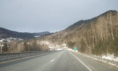
before reaching the "twin cities" of Barre and Montpelier in the middle of Vermont. The interstate's highest point was said to be in the town of Brookfield, although the sign that made the declaration was taken down in the late 1990s.
Another directional shift, again to the northwest, occurs while passing the interchange for Montpelier
. For the next 40 miles (64 km), I-89's path isn't so much chosen as it is logical: paralleling the Winooski River
and U.S. Route 2
, the highway cuts through the section of the Appalachians
known as the Green Mountains
, and is surrounded by peaks of over 4,000 feet (1,219 m), such as Camel's Hump. U.S. 2 crosses the Interstate frequently, and has several interchanges with it, en route to Burlington.
Interstate 89 was unique due to one instance of its signage. Between (Vermont) Exits 9 & 10, a sign showing the distance to the next control cities in each direction was completely in metric. While there are many instances of signs being in both miles and kilometres, this was the only case of solely metric in the entire Interstate System. Both signs were replaced in 2010 and show distances in miles only. (Interstate 19
in Arizona
used to be the other "only signed in metric" interstate in the U.S., but has been changed over in recent years as the last 2 km have been changed.) Speed limit signs have always been posted in mph.
After Exit 11 in Richmond
, I-89 leaves the Green Mountains to enter the Champlain Valley and a notable shift in the landscape is visible. Here, just outside of Burlington
, the highway turns northward once again. Also, at this turn is where the only official auxiliary highway starts, Interstate 189
. A second highway, Interstate 289, was proposed as a beltway through Burlington's northeastern suburbs in the 1980s; amidst controversy, the highway has only been partially completed as Vermont Route 289
, a Super two
roadway. It has yet to directly meet its parent.
Passing I-189, I-89 sees the busiest freeway interchange in the entire state, Exit 14. A full cloverleaf interchange at this exit provides access to downtown Burlington, the University of Vermont
, and the retail-heavy Dorset Street, via U.S. 2. Heading north from Burlington, the landscape quickly fades from suburban development into rolling hills more characteristic of northern New England, providing a vista overlooking Lake Champlain
. I-89 passes through Milton, Georgia, St. Albans, Swanton, and finally the border town of Highgate Springs. The highway ends at the Canadian border in Highgate Springs
. Its final exit, which northbound motorists can use to reverse direction onto I-89 south without crossing the border, is Exit 22 - the highest exit number along the route. U.S. Route 7
has its northern terminus at this interchange as well.
Although the divided highway continues about 5 miles (8 km) into Phillipsburg, Quebec as Route 133
, this changes back to a two-lane road, until Autoroute 35
starts outside of Saint-Jean-sur-Richelieu, Quebec
, and continues to Montreal
. The I-89 border crossing is the only instance where an Interstate entering Quebec
does not become an Autoroute upon entry. However, Autoroute 35
will be extended in the next few years, creating a freeway-to-freeway connection.
New England
New England is a region in the northeastern corner of the United States consisting of the six states of Maine, New Hampshire, Vermont, Massachusetts, Rhode Island, and Connecticut...
region of the United States
United States
The United States of America is a federal constitutional republic comprising fifty states and a federal district...
travelling between Bow, New Hampshire
Bow, New Hampshire
Bow is a town in Merrimack County, New Hampshire, United States. The population was 7,519 at the 2010 census.- History :Incorporated in 1727, the town was one of several formed to ease population pressures on the Seacoast. The town's name comes from its establishment along a bend, or "bow", in the...
and Highgate Springs, Vermont. As with all odd-numbered primary interstates, I-89 is signed as a north–south highway. However, the northwest-to-southeast path the road actually takes, serves in two capacities: as an east–west interstate highway north of Interstate 90
Interstate 90
Interstate 90 is the longest Interstate Highway in the United States at . It is the northernmost coast-to-coast interstate, and parallels US 20 for the most part. Its western terminus is in Seattle, at Edgar Martinez Drive S. near Safeco Field and CenturyLink Field, and its eastern terminus is in...
in New England, and as a substantial part of the main connection between the major cities of Montreal
Montreal
Montreal is a city in Canada. It is the largest city in the province of Quebec, the second-largest city in Canada and the seventh largest in North America...
and Boston
Boston
Boston is the capital of and largest city in Massachusetts, and is one of the oldest cities in the United States. The largest city in New England, Boston is regarded as the unofficial "Capital of New England" for its economic and cultural impact on the entire New England region. The city proper had...
. The largest cities directly served by I-89 are Concord, New Hampshire
Concord, New Hampshire
The city of Concord is the capital of the state of New Hampshire in the United States. It is also the county seat of Merrimack County. As of the 2010 census, its population was 42,695....
and Burlington, Vermont
Burlington, Vermont
Burlington is the largest city in the U.S. state of Vermont and the shire town of Chittenden County. Burlington lies south of the U.S.-Canadian border and some south of Montreal....
. I-89 is one of three Interstate highways whose entire route is located within the New England states.
Interstate 89 connects smaller cities and rural areas within New Hampshire and Vermont, and maintains two lanes of traffic in each direction throughout the route. Unlike its neighboring Interstates (91
Interstate 91
Interstate 91 is an Interstate Highway in the New England region of the United States. It provides the primary north–south thoroughfare in the western part of New England...
and 93
Interstate 93
Interstate 93 is an Interstate Highway in the New England section of the United States. Its southern terminus is in Canton, Massachusetts, in the Boston metropolitan area, at Interstate 95; its northern terminus is near St. Johnsbury, Vermont, at Interstate 91...
), it does not intersect any even-numbered Interstates along its route. It does, however, parallel (and interchange multiple times with) portions of three U.S. routes: U.S. Route 4
U.S. Route 4
U.S. Route 4 is a long United States highway that runs from East Greenbush, New York, in the west to Portsmouth, New Hampshire, in the east, traversing through Vermont.In New York, US 4 is signed north–south to reflect its alignment in the state...
from Enfield
Enfield, New Hampshire
Enfield is a town in Grafton County, New Hampshire, United States. The population was 4,582 at the 2010 census. The town includes the villages of Enfield, Enfield Center, Upper Shaker Village, Lower Shaker Village, Lockehaven, and Montcalm....
to White River Junction
White River Junction, Vermont
White River Junction is an unincorporated village and census-designated place in the town of Hartford in Windsor County, Vermont, United States...
; U.S. Route 2
U.S. Route 2
U.S. Route 2 is an east–west U.S. Highway spanning across the northern continental United States. US 2 consists of two segments connected by various roadways in southern Canada...
from Montpelier
Montpelier, Vermont
Montpelier is a city in the U.S. state of Vermont that serves as the state capital and the shire town of Washington County. As the capital of Vermont, Montpelier is the site of the Vermont State House, seat of the legislative branch of Vermont government. The population was 7,855 at the 2010...
to Colchester
Colchester, Vermont
Colchester is a town in Chittenden County, Vermont, United States. The population was 17,067 at the 2010 census. It is the fourth-largest municipality and second-largest town in Vermont by population.-Geography:...
, and U.S. Route 7
U.S. Route 7
U.S. Route 7 is a north–south United States highway in western New England that runs for from Norwalk, Connecticut, to Highgate, Vermont. The highway's southern terminus is at Interstate 95 in Norwalk, Connecticut...
from Burlington
Burlington, Vermont
Burlington is the largest city in the U.S. state of Vermont and the shire town of Chittenden County. Burlington lies south of the U.S.-Canadian border and some south of Montreal....
to the Canadian border.
Route description
|-|NH
New Hampshire
New Hampshire is a state in the New England region of the northeastern United States of America. The state was named after the southern English county of Hampshire. It is bordered by Massachusetts to the south, Vermont to the west, Maine and the Atlantic Ocean to the east, and the Canadian...
|| 60.80 || 97.89
|-
|VT
Vermont
Vermont is a state in the New England region of the northeastern United States of America. The state ranks 43rd in land area, , and 45th in total area. Its population according to the 2010 census, 630,337, is the second smallest in the country, larger only than Wyoming. It is the only New England...
|| 130.25 || 209.70
|-
|Total || 191.05 || 307.59
|}
New Hampshire
Interstate 89 runs for about 60.6 miles (97.5 km) in the state of New Hampshire, and is the major freeway corridor through the western part of the state. Despite being signed as a north–south freeway, its first 8 miles (12.9 km) actually run east–west before shifting to the northwest. The two major population centers along I-89's length in New Hampshire are ConcordConcord, New Hampshire
The city of Concord is the capital of the state of New Hampshire in the United States. It is also the county seat of Merrimack County. As of the 2010 census, its population was 42,695....
, at its southern terminus, and Lebanon
Lebanon, New Hampshire
As of the census of 2000, there were 12,568 people, 5,500 households, and 3,178 families residing in the city. The population density was 311.4 people per square mile . There were 5,707 housing units at an average density of 141.4 per square mile...
, on the Vermont border. Mileage signs along I-89 in each direction consistently list one of the two cities. Also located along I-89 in New Hampshire are the towns of Grantham
Grantham, New Hampshire
Grantham is a town in Sullivan County, New Hampshire, United States. The population was 2,985 at the 2010 census. This made Grantham the fastest growing town numerically in Sullivan County between the 2000 and 2010 censuses...
, New London
New London, New Hampshire
New London is a town in Merrimack County, New Hampshire, United States. The population was 4,397 at the 2010 census.The town center, where 1,415 people resided at the 2010 census, is defined as the New London census-designated place , and is located on a hilltop along New Hampshire Route 114 north...
and Warner
Warner, New Hampshire
Warner is a town in Merrimack County, New Hampshire, United States. The population was 2,833 at the 2010 census. The town is home to The College of Saint Mary Magdalen, Rollins State Park and Mount Kearsarge State Forest....
.
Starting at an intersection with Interstate 93
Interstate 93
Interstate 93 is an Interstate Highway in the New England section of the United States. Its southern terminus is in Canton, Massachusetts, in the Boston metropolitan area, at Interstate 95; its northern terminus is near St. Johnsbury, Vermont, at Interstate 91...
and New Hampshire Route 3A
New Hampshire Route 3A
New Hampshire Route 3A is a designation held by two separate state highways in New Hampshire. The two segments, although not directly connected, are linked by U.S. Route 3, from which they derive their route number.-Southern segment:...
in the town of Bow
Bow, New Hampshire
Bow is a town in Merrimack County, New Hampshire, United States. The population was 7,519 at the 2010 census.- History :Incorporated in 1727, the town was one of several formed to ease population pressures on the Seacoast. The town's name comes from its establishment along a bend, or "bow", in the...
, just south of the New Hampshire
New Hampshire
New Hampshire is a state in the New England region of the northeastern United States of America. The state was named after the southern English county of Hampshire. It is bordered by Massachusetts to the south, Vermont to the west, Maine and the Atlantic Ocean to the east, and the Canadian...
capital city of Concord
Concord, New Hampshire
The city of Concord is the capital of the state of New Hampshire in the United States. It is also the county seat of Merrimack County. As of the 2010 census, its population was 42,695....
, the highway runs a northwest path through the Dartmouth-Lake Sunapee Region
Dartmouth-Lake Sunapee Region
The Dartmouth-Lake Sunapee area of the U.S. state of New Hampshire, ranges from Bradford northwest along Interstate 89 to New Hampshire's border with Vermont at the city of Lebanon....
. One exit directly serves Concord (Exit 2) before the highway enters the neighboring town of Hopkinton
Hopkinton, New Hampshire
Hopkinton is a town in Merrimack County, New Hampshire, United States. The population was 5,589 at the 2010 census. It consists of three villages: Hopkinton, West Hopkinton, and Contoocook...
. east–west New Hampshire Route 11
New Hampshire Route 11
New Hampshire Route 11 is a long east–west state highway in New Hampshire, running westward along the southern shore of Lake Winnipesaukee. Its eastern terminus is at the Maine state line in the city of Rochester, where it continues north as Maine State Route 11. U.S. Route 202, which runs...
joins I-89 at Exit 11 and runs concurrently with it for about 3 miles (4.8 km) before departing at Exit 12. At Exit 13 in Grantham
Grantham, New Hampshire
Grantham is a town in Sullivan County, New Hampshire, United States. The population was 2,985 at the 2010 census. This made Grantham the fastest growing town numerically in Sullivan County between the 2000 and 2010 censuses...
, New Hampshire Route 10
New Hampshire Route 10
New Hampshire Route 10 is a north–south state highway in the U.S. state of New Hampshire. Its southern terminus is at the Massachusetts state line in the town of Winchester. In Massachusetts the highway becomes Massachusetts Route 10. Total length of the highway is .-Route description:NH 10...
enters I-89, and the pair of highways form another concurrency, this one for about 15 miles (24.1 km). Guide signs for exit 16 southeast of Lebanon
Lebanon, New Hampshire
As of the census of 2000, there were 12,568 people, 5,500 households, and 3,178 families residing in the city. The population density was 311.4 people per square mile . There were 5,707 housing units at an average density of 141.4 per square mile...
display the name "Purmort", a made-up name taken from the name of an early settler in order to meet naming conventions for interstate exits. However, a community by that name has now taken root around the exit.
The highway continues northwest, passing through Lebanon, in which the Dartmouth-Hitchcock Medical Center
Dartmouth-Hitchcock Medical Center
Dartmouth-Hitchcock Medical Center is New Hampshire's only academic medical center and is headquartered on a campus in the heart of the Upper Connecticut River Valley, in Lebanon, New Hampshire....
is located. A few miles north of this point is Dartmouth College
Dartmouth College
Dartmouth College is a private, Ivy League university in Hanover, New Hampshire, United States. The institution comprises a liberal arts college, Dartmouth Medical School, Thayer School of Engineering, and the Tuck School of Business, as well as 19 graduate programs in the arts and sciences...
. U.S. Route 4
U.S. Route 4
U.S. Route 4 is a long United States highway that runs from East Greenbush, New York, in the west to Portsmouth, New Hampshire, in the east, traversing through Vermont.In New York, US 4 is signed north–south to reflect its alignment in the state...
parallels I-89 through Lebanon. Exits 17-20 serve the city of Lebanon and are passed in quick succession. At Exit 19, northbound New Hampshire Route 10
New Hampshire Route 10
New Hampshire Route 10 is a north–south state highway in the U.S. state of New Hampshire. Its southern terminus is at the Massachusetts state line in the town of Winchester. In Massachusetts the highway becomes Massachusetts Route 10. Total length of the highway is .-Route description:NH 10...
separates from I-89 and joins westbound U.S. Route 4
U.S. Route 4
U.S. Route 4 is a long United States highway that runs from East Greenbush, New York, in the west to Portsmouth, New Hampshire, in the east, traversing through Vermont.In New York, US 4 is signed north–south to reflect its alignment in the state...
to pass through West Lebanon
West Lebanon, New Hampshire
West Lebanon, New Hampshire, is a district within the city of Lebanon on the Connecticut River. The area contains a major shopping plaza strip along New Hampshire Route 12A, serving the Upper Valley communities along Interstates 89 and 91...
. The final exit in New Hampshire is Exit 20, providing access to West Lebanon's large retail district along New Hampshire Route 12A. Just after this interchange, the highway crosses the Connecticut River
Connecticut River
The Connecticut River is the largest and longest river in New England, and also an American Heritage River. It flows roughly south, starting from the Fourth Connecticut Lake in New Hampshire. After flowing through the remaining Connecticut Lakes and Lake Francis, it defines the border between the...
and enters Vermont
Vermont
Vermont is a state in the New England region of the northeastern United States of America. The state ranks 43rd in land area, , and 45th in total area. Its population according to the 2010 census, 630,337, is the second smallest in the country, larger only than Wyoming. It is the only New England...
, where it remains for the rest of its run northwest to the Canadian border.
Vermont
Montpelier, Vermont
Montpelier is a city in the U.S. state of Vermont that serves as the state capital and the shire town of Washington County. As the capital of Vermont, Montpelier is the site of the Vermont State House, seat of the legislative branch of Vermont government. The population was 7,855 at the 2010...
) and largest city (Burlington
Burlington, Vermont
Burlington is the largest city in the U.S. state of Vermont and the shire town of Chittenden County. Burlington lies south of the U.S.-Canadian border and some south of Montreal....
). Other important cities and towns located along I-89 are Barre, Waterbury
Waterbury, Vermont
Waterbury is a town in Washington County in central Vermont, in the United States. It is also the name of a village within that town. The population was 4,915 at the 2000 census.-Economy:-Industry:...
, and St. Albans
St. Albans, Vermont
Places named St. Albans, Vermont:*St. Albans , Vermont, town in Franklin County, Vermont, established in 1763**St. Albans Raid, 1864*St. Albans , Vermont, city in Franklin County, Vermont, established in 1902...
. Williston
Williston, Vermont
Williston is a town in Chittenden County, Vermont, United States. The population was 8,698 at the 2010 census, an increase of over 1,000 people since the 2000 census...
, which has become Burlington's big-box retail center (and one of the fastest-growing towns in the state) over the past decade, also has an interchange along I-89.
Crossing the Connecticut River
Connecticut River
The Connecticut River is the largest and longest river in New England, and also an American Heritage River. It flows roughly south, starting from the Fourth Connecticut Lake in New Hampshire. After flowing through the remaining Connecticut Lakes and Lake Francis, it defines the border between the...
into Vermont, I-89 continues the northwesterly direction it carried in New Hampshire. The Interstate intersects I-91
Interstate 91
Interstate 91 is an Interstate Highway in the New England region of the United States. It provides the primary north–south thoroughfare in the western part of New England...
at an unnumbered interchange immediately upon entering Vermont. Shortly afterward, another interchange with U.S. 4
U.S. Route 4
U.S. Route 4 is a long United States highway that runs from East Greenbush, New York, in the west to Portsmouth, New Hampshire, in the east, traversing through Vermont.In New York, US 4 is signed north–south to reflect its alignment in the state...
occurs. The highway begins to enter the scenic rolling hills of Vermont, turning almost due northward about 20 miles (32 kilometres) from the New Hampshire
New Hampshire
New Hampshire is a state in the New England region of the northeastern United States of America. The state was named after the southern English county of Hampshire. It is bordered by Massachusetts to the south, Vermont to the west, Maine and the Atlantic Ocean to the east, and the Canadian...
state line, and continues through the high country of central Vermont. The Interstate passes through the towns of Sharon
Sharon, Vermont
Sharon is a town in Windsor County, Vermont, United States. It had a population of 1,411 at the 2000 census. The town is home to The Sharon Academy.-History:...
, Royalton
Royalton, Vermont
Royalton is a town in Windsor County, Vermont, United States. The population was 2,603 at the 2000 census. It includes the villages of Royalton, South Royalton, and North Royalton...
, Bethel
Bethel, Vermont
Bethel is a town in Windsor County, Vermont, United States. The population was 1,968 at the 2000 census. The town includes the locations of Bethel-Gilead, East Bethel, Lilliesville, Lympus , and West Bethel...
, Randolph
Randolph, Vermont
Randolph is a town in Orange County, Vermont, United States. The population was 4,853 at the 2000 census, making Randolph the largest town in Orange County. The town is a commercial center for many of the smaller, rural farming communities that surround it....
, Brookfield
Brookfield, Vermont
Brookfield is a town in Orange County, Vermont, United States. It was created by Vermont charter on August 5, 1781. The population was 1,222 at the 2000 census. Brookfield is best known for its floating bridge which spans Sunset Lake buoyed by pontoons...
, and Williamstown
Williamstown, Vermont
Williamstown is a town in Orange County, Vermont, United States. The population was 3,225 at the 2000 census.-Geography:According to the United States Census Bureau, the town has a total area of 40.3 square miles , of which 40.2 square miles is land and 0.2 square mile is...
before reaching the "twin cities" of Barre and Montpelier in the middle of Vermont. The interstate's highest point was said to be in the town of Brookfield, although the sign that made the declaration was taken down in the late 1990s.
Another directional shift, again to the northwest, occurs while passing the interchange for Montpelier
Montpelier, Vermont
Montpelier is a city in the U.S. state of Vermont that serves as the state capital and the shire town of Washington County. As the capital of Vermont, Montpelier is the site of the Vermont State House, seat of the legislative branch of Vermont government. The population was 7,855 at the 2010...
. For the next 40 miles (64 km), I-89's path isn't so much chosen as it is logical: paralleling the Winooski River
Winooski River
The Winooski River is a tributary of Lake Champlain, approximately long, in northern Vermont in the United States. Although not Vermont's longest river, it is one of the state's most significant, forming a major valley way from Lake Champlain through the Green Mountains towards the Connecticut...
and U.S. Route 2
U.S. Route 2
U.S. Route 2 is an east–west U.S. Highway spanning across the northern continental United States. US 2 consists of two segments connected by various roadways in southern Canada...
, the highway cuts through the section of the Appalachians
Appalachian Mountains
The Appalachian Mountains #Whether the stressed vowel is or ,#Whether the "ch" is pronounced as a fricative or an affricate , and#Whether the final vowel is the monophthong or the diphthong .), often called the Appalachians, are a system of mountains in eastern North America. The Appalachians...
known as the Green Mountains
Green Mountains
The Green Mountains are a mountain range in the U.S. state of Vermont. The range extends approximately .-Peaks:The most notable mountains in the range include:*Mount Mansfield, , the highest point in Vermont*Killington Peak, *Mount Ellen,...
, and is surrounded by peaks of over 4,000 feet (1,219 m), such as Camel's Hump. U.S. 2 crosses the Interstate frequently, and has several interchanges with it, en route to Burlington.
Interstate 89 was unique due to one instance of its signage. Between (Vermont) Exits 9 & 10, a sign showing the distance to the next control cities in each direction was completely in metric. While there are many instances of signs being in both miles and kilometres, this was the only case of solely metric in the entire Interstate System. Both signs were replaced in 2010 and show distances in miles only. (Interstate 19
Interstate 19
Interstate 19 is an intrastate Interstate Highway located entirely within the state of Arizona. I-19 runs from Nogales, roughly 1,500 feet from the Mexican border, to Tucson, at Interstate 10...
in Arizona
Arizona
Arizona ; is a state located in the southwestern region of the United States. It is also part of the western United States and the mountain west. The capital and largest city is Phoenix...
used to be the other "only signed in metric" interstate in the U.S., but has been changed over in recent years as the last 2 km have been changed.) Speed limit signs have always been posted in mph.
After Exit 11 in Richmond
Richmond, Vermont
Richmond is a town in Chittenden County, Vermont, United States. The 2000 census revealed a population of 4,090.Local students attend Mount Mansfield Union High School, Camel's Hump Middle School, And Richmond Elementary School. Mount Mansfield Union High is in the neighboring town of Jericho...
, I-89 leaves the Green Mountains to enter the Champlain Valley and a notable shift in the landscape is visible. Here, just outside of Burlington
Burlington, Vermont
Burlington is the largest city in the U.S. state of Vermont and the shire town of Chittenden County. Burlington lies south of the U.S.-Canadian border and some south of Montreal....
, the highway turns northward once again. Also, at this turn is where the only official auxiliary highway starts, Interstate 189
Interstate 189
Interstate 189 is an auxiliary Interstate Highway in Chittenden County, Vermont, United States. The highway extends for from Interstate 89 exit 13 in South Burlington to U.S. Route 7 just inside the Burlington city limits...
. A second highway, Interstate 289, was proposed as a beltway through Burlington's northeastern suburbs in the 1980s; amidst controversy, the highway has only been partially completed as Vermont Route 289
Vermont Route 289
Vermont Route 289 is a state highway located within the town of Essex in Chittenden County, Vermont, United States. It is a long limited-access highway that extends from VT 2A southeast to VT 117 on the north bank of the Winooski River...
, a Super two
Super two
A super two, super two-lane highway or wide two lane is a two-lane surface road built to high standards, typically including partial control of access, occasional passing lanes and hard shoulders...
roadway. It has yet to directly meet its parent.
Passing I-189, I-89 sees the busiest freeway interchange in the entire state, Exit 14. A full cloverleaf interchange at this exit provides access to downtown Burlington, the University of Vermont
University of Vermont
The University of Vermont comprises seven undergraduate schools, an honors college, a graduate college, and a college of medicine. The Honors College does not offer its own degrees; students in the Honors College concurrently enroll in one of the university's seven undergraduate colleges or...
, and the retail-heavy Dorset Street, via U.S. 2. Heading north from Burlington, the landscape quickly fades from suburban development into rolling hills more characteristic of northern New England, providing a vista overlooking Lake Champlain
Lake Champlain
Lake Champlain is a natural, freshwater lake in North America, located mainly within the borders of the United States but partially situated across the Canada—United States border in the Canadian province of Quebec.The New York portion of the Champlain Valley includes the eastern portions of...
. I-89 passes through Milton, Georgia, St. Albans, Swanton, and finally the border town of Highgate Springs. The highway ends at the Canadian border in Highgate Springs
Highgate, Vermont
Highgate is a town in Franklin County, Vermont, United States. The population was 3,397 at the 2000 census. The town is on the border of Quebec, Canada and is a border town of Philipsburg, Quebec.-History:...
. Its final exit, which northbound motorists can use to reverse direction onto I-89 south without crossing the border, is Exit 22 - the highest exit number along the route. U.S. Route 7
U.S. Route 7
U.S. Route 7 is a north–south United States highway in western New England that runs for from Norwalk, Connecticut, to Highgate, Vermont. The highway's southern terminus is at Interstate 95 in Norwalk, Connecticut...
has its northern terminus at this interchange as well.
Although the divided highway continues about 5 miles (8 km) into Phillipsburg, Quebec as Route 133
Quebec route 133
Route 133 is a historic and heritage road of the Montérégie region in the province of Quebec, with north/south orientation and located on the eastern shore of the Richelieu River...
, this changes back to a two-lane road, until Autoroute 35
Quebec Autoroute 35
Autoroute 35 is a north-south Autoroute in southern Quebec. It currently runs from Saint-Jean-sur-Richelieu to Autoroute 10 in Chambly....
starts outside of Saint-Jean-sur-Richelieu, Quebec
Quebec
Quebec or is a province in east-central Canada. It is the only Canadian province with a predominantly French-speaking population and the only one whose sole official language is French at the provincial level....
, and continues to Montreal
Montreal
Montreal is a city in Canada. It is the largest city in the province of Quebec, the second-largest city in Canada and the seventh largest in North America...
. The I-89 border crossing is the only instance where an Interstate entering Quebec
Quebec
Quebec or is a province in east-central Canada. It is the only Canadian province with a predominantly French-speaking population and the only one whose sole official language is French at the provincial level....
does not become an Autoroute upon entry. However, Autoroute 35
Quebec Autoroute 35
Autoroute 35 is a north-south Autoroute in southern Quebec. It currently runs from Saint-Jean-sur-Richelieu to Autoroute 10 in Chambly....
will be extended in the next few years, creating a freeway-to-freeway connection.
Exit list
Exits are numbered consecutively.| County | Location | Mile | # Exit number An exit number is a number assigned to a road junction, usually an exit from a freeway. It is usually marked on the same sign as the destinations of the exit, as well as a sign in the gore.... |
Destinations | Notes |
|---|---|---|---|---|---|
New Hampshire |
|||||
| Merrimack Merrimack County, New Hampshire -Demographics:As of the census of 2000, there were 136,225 people, 51,843 households, and 35,460 families residing in the county. The population density was 146 people per square mile . There were 56,244 housing units at an average density of 60 per square mile... |
Bow Bow, New Hampshire Bow is a town in Merrimack County, New Hampshire, United States. The population was 7,519 at the 2010 census.- History :Incorporated in 1727, the town was one of several formed to ease population pressures on the Seacoast. The town's name comes from its establishment along a bend, or "bow", in the... |
.svg.png) NH Route 3A NH Route 3ANew Hampshire Route 3A New Hampshire Route 3A is a designation held by two separate state highways in New Hampshire. The two segments, although not directly connected, are linked by U.S. Route 3, from which they derive their route number.-Southern segment:... |
At-grade intersection. | ||
Southern terminus of  I-89 designation. I-89 designation. |
|||||
| 0.0 |        I-93 I-93Interstate 93 Interstate 93 is an Interstate Highway in the New England section of the United States. Its southern terminus is in Canton, Massachusetts, in the Boston metropolitan area, at Interstate 95; its northern terminus is near St. Johnsbury, Vermont, at Interstate 91... North to I-393 Interstate 393 Interstate 393 is a spur extending east from Interstate 93 at Concord, New Hampshire, USA. The primary purpose of the road is to bypass a densely-built commercial strip on Route 9 in the eastern part of Concord. Several times a year, I-393 also serves traffic to events at New Hampshire Motor... /US-4 U.S. Route 4 U.S. Route 4 is a long United States highway that runs from East Greenbush, New York, in the west to Portsmouth, New Hampshire, in the east, traversing through Vermont.In New York, US 4 is signed north–south to reflect its alignment in the state... - Concord Concord, New Hampshire The city of Concord is the capital of the state of New Hampshire in the United States. It is also the county seat of Merrimack County. As of the 2010 census, its population was 42,695.... , Seacoast Seacoast Region (New Hampshire) The Seacoast Region is the southeast area of the U.S. state of New Hampshire. The region stretches 18 miles along the Atlantic Ocean from New Hampshire's border with Salisbury, Massachusetts to the Piscataqua River and New Hampshire's border with Kittery, Maine. The shoreline is generally very...  Interstate 93 Interstate 93Interstate 93 Interstate 93 is an Interstate Highway in the New England section of the United States. Its southern terminus is in Canton, Massachusetts, in the Boston metropolitan area, at Interstate 95; its northern terminus is near St. Johnsbury, Vermont, at Interstate 91... South - Manchester Manchester, New Hampshire Manchester is the largest city in the U.S. state of New Hampshire, the tenth largest city in New England, and the largest city in northern New England, an area comprising the states of Maine, New Hampshire, and Vermont. It is in Hillsborough County along the banks of the Merrimack River, which... , Boston |
||||
| 0.2 | 1 | Logging Hill Road - Bow Bow, New Hampshire Bow is a town in Merrimack County, New Hampshire, United States. The population was 7,519 at the 2010 census.- History :Incorporated in 1727, the town was one of several formed to ease population pressures on the Seacoast. The town's name comes from its establishment along a bend, or "bow", in the... |
Signed "Local traffic only." | ||
| Concord Concord, New Hampshire The city of Concord is the capital of the state of New Hampshire in the United States. It is also the county seat of Merrimack County. As of the 2010 census, its population was 42,695.... |
2.1 | 2 |  NH Route 13 NH Route 13New Hampshire Route 13 New Hampshire Route 13 is a long north–south state highway in the state of New Hampshire, United States. The highway runs from Brookline to Concord.... (Clinton Street) - Concord Concord, New Hampshire The city of Concord is the capital of the state of New Hampshire in the United States. It is also the county seat of Merrimack County. As of the 2010 census, its population was 42,695.... |
||
| 3.8 | 3 | Stickney Hill Road | Northbound exit/southbound entrance only. | ||
| Hopkinton Hopkinton, New Hampshire Hopkinton is a town in Merrimack County, New Hampshire, United States. The population was 5,589 at the 2010 census. It consists of three villages: Hopkinton, West Hopkinton, and Contoocook... |
6.6 | 4 |     US-202/NH-9 to NH-103 US-202/NH-9 to NH-103New Hampshire Route 103 New Hampshire Route 103 is a long east–west highway in west-central New Hampshire, United States. The highway runs from Claremont, near the Vermont border on the Connecticut River, to Hopkinton, west of Concord.... - Hopkinton Hopkinton, New Hampshire Hopkinton is a town in Merrimack County, New Hampshire, United States. The population was 5,589 at the 2010 census. It consists of three villages: Hopkinton, West Hopkinton, and Contoocook... |
Northbound exit, southbound entrance only. | |
| 8.5 | 5 | US 202 U.S. Route 202 U.S. Route 202 is a highway stretching from Delaware to Maine, also passing through the states of Pennsylvania, New Jersey, New York, Connecticut, Massachusetts, and New Hampshire.... /NH 9 - Henniker Henniker, New Hampshire Henniker is a town in Merrimack County, New Hampshire, United States. As of the 2010 census, the town had a total population of 4,836. Henniker is home to New England College, Ames State Forest and Craney Hill State Forest.... , Keene Keene, New Hampshire Keene is a city in Cheshire County, New Hampshire, United States. The population was 23,409 at the 2010 census. It is the county seat of Cheshire County.Keene is home to Keene State College and Antioch University New England, and hosts the annual Pumpkin Fest... (north); Hopkinton (south) |
Left exit northbound. Access to US-202/NH-9 West only from I-89 North. Access to I-89 North only from US-202/NH-9 West. Access to I-89 South only from US-202/NH-9 East. |
||
| 10.4 | 6 |  NH Route 127 NH Route 127New Hampshire Route 127 New Hampshire Route 127 is a north–south state highway in central New Hampshire. The highway runs from Hopkinton in Merrimack County northward to Sanbornton in Belknap County.... - Contoocook Contoocook, New Hampshire Contoocook is a village and census-designated place within the town of Hopkinton in Merrimack County, New Hampshire, United States. The population was 1,444 at the 2010 census.-History:... , West Hopkinton |
|||
| Warner Warner, New Hampshire Warner is a town in Merrimack County, New Hampshire, United States. The population was 2,833 at the 2010 census. The town is home to The College of Saint Mary Magdalen, Rollins State Park and Mount Kearsarge State Forest.... |
14.2 | 7 | NH Route 103 New Hampshire Route 103 New Hampshire Route 103 is a long east–west highway in west-central New Hampshire, United States. The highway runs from Claremont, near the Vermont border on the Connecticut River, to Hopkinton, west of Concord.... - Davisville, Contoocook |
To NH Route 127 New Hampshire Route 127 New Hampshire Route 127 is a north–south state highway in central New Hampshire. The highway runs from Hopkinton in Merrimack County northward to Sanbornton in Belknap County.... . |
|
| 17.4 | 8 | NH Route 103 - Warner Warner, New Hampshire Warner is a town in Merrimack County, New Hampshire, United States. The population was 2,833 at the 2010 census. The town is home to The College of Saint Mary Magdalen, Rollins State Park and Mount Kearsarge State Forest.... |
Northbound exit/southbound entrance only. | ||
| 20.0 | 9 | NH Route 103 - Warner, Bradford Bradford, New Hampshire Bradford is a town in Merrimack County, New Hampshire, United States. The population was 1,650 at the 2010 census. The main village of the town, where 356 people resided at the 2010 census, is defined as the Bradford census-designated place , and is located west of the junction of New Hampshire... |
|||
| Sutton Sutton, New Hampshire Sutton is a town in Merrimack County, New Hampshire, United States. The population was 1,837 at the 2010 census. Sutton is home to Wadleigh State Beach on Kezar Lake.-History:... |
27.2 | 10 | North Road | To Sutton Sutton, New Hampshire Sutton is a town in Merrimack County, New Hampshire, United States. The population was 1,837 at the 2010 census. Sutton is home to Wadleigh State Beach on Kezar Lake.-History:... via  NH 114 NH 114New Hampshire Route 114 New Hampshire Route 114 is a long secondary north–south highway in central New Hampshire. The highway runs between Bedford, in Hillsborough County and Grantham, in Sullivan County.... . |
|
| New London New London, New Hampshire New London is a town in Merrimack County, New Hampshire, United States. The population was 4,397 at the 2010 census.The town center, where 1,415 people resided at the 2010 census, is defined as the New London census-designated place , and is located on a hilltop along New Hampshire Route 114 north... |
31.2 | 11 |   NH Route 11 NH Route 11New Hampshire Route 11 New Hampshire Route 11 is a long east–west state highway in New Hampshire, running westward along the southern shore of Lake Winnipesaukee. Its eastern terminus is at the Maine state line in the city of Rochester, where it continues north as Maine State Route 11. U.S. Route 202, which runs... East (King Hill Road) - New London New London, New Hampshire New London is a town in Merrimack County, New Hampshire, United States. The population was 4,397 at the 2010 census.The town center, where 1,415 people resided at the 2010 census, is defined as the New London census-designated place , and is located on a hilltop along New Hampshire Route 114 north... |
To NH Route 114 New Hampshire Route 114 New Hampshire Route 114 is a long secondary north–south highway in central New Hampshire. The highway runs between Bedford, in Hillsborough County and Grantham, in Sullivan County.... . |
|
| I-89 and NH 11 New Hampshire Route 11 New Hampshire Route 11 is a long east–west state highway in New Hampshire, running westward along the southern shore of Lake Winnipesaukee. Its eastern terminus is at the Maine state line in the city of Rochester, where it continues north as Maine State Route 11. U.S. Route 202, which runs... form a 3.7 miles (6 km) long concurrency Concurrency (road) A concurrency, overlap, or coincidence in a road network is an instance of one physical road bearing two or more different highway, motorway, or other route numbers... . |
|||||
| 34.9 | 12 |   NH-11 NH-11New Hampshire Route 11 New Hampshire Route 11 is a long east–west state highway in New Hampshire, running westward along the southern shore of Lake Winnipesaukee. Its eastern terminus is at the Maine state line in the city of Rochester, where it continues north as Maine State Route 11. U.S. Route 202, which runs... West to NH-103A - New London, Sunapee Sunapee, New Hampshire Sunapee is a town in Sullivan County, New Hampshire, United States. The population was 3,365 at the 2010 census. Sunapee is home to part of Lake Sunapee... |
|||
| Sullivan Sullivan County, New Hampshire -Demographics:As of the census of 2000, there were 40,458 people, 16,530 households, and 11,174 families residing in the county. The population density was 29/; . There were 20,158 housing units at an average density of 38 per square mile... |
Sunapee Sunapee, New Hampshire Sunapee is a town in Sullivan County, New Hampshire, United States. The population was 3,365 at the 2010 census. Sunapee is home to part of Lake Sunapee... |
37.0 | 12A | To NH Route 114 New Hampshire Route 114 New Hampshire Route 114 is a long secondary north–south highway in central New Hampshire. The highway runs between Bedford, in Hillsborough County and Grantham, in Sullivan County.... - Georges Mills Georges Mills, New Hampshire Georges Mills is an unincorporated village in the town of Sunapee in Sullivan County, New Hampshire, in the United States. It is located in the northeast corner of the town, on a strip of land between the north end of Lake Sunapee and the south shore of Otter Pond. New Hampshire Route 11 runs... , Springfield Springfield, New Hampshire Springfield is a town in Sullivan County, New Hampshire, United States. The population was 1,311 at the 2010 census. Gile State Forest is located within the town.-History:... |
To NH Route 11 New Hampshire Route 11 New Hampshire Route 11 is a long east–west state highway in New Hampshire, running westward along the southern shore of Lake Winnipesaukee. Its eastern terminus is at the Maine state line in the city of Rochester, where it continues north as Maine State Route 11. U.S. Route 202, which runs... . |
| Grantham Grantham, New Hampshire Grantham is a town in Sullivan County, New Hampshire, United States. The population was 2,985 at the 2010 census. This made Grantham the fastest growing town numerically in Sullivan County between the 2000 and 2010 censuses... |
43.0 | 13 |   NH Route 10 NH Route 10New Hampshire Route 10 New Hampshire Route 10 is a north–south state highway in the U.S. state of New Hampshire. Its southern terminus is at the Massachusetts state line in the town of Winchester. In Massachusetts the highway becomes Massachusetts Route 10. Total length of the highway is .-Route description:NH 10... South - Grantham Grantham, New Hampshire Grantham is a town in Sullivan County, New Hampshire, United States. The population was 2,985 at the 2010 census. This made Grantham the fastest growing town numerically in Sullivan County between the 2000 and 2010 censuses... , Croydon Croydon, New Hampshire Croydon is a town in Sullivan County, New Hampshire, United States. The population was 764 at the 2010 census.- History :Incorporated in 1763, the town takes its name from Croydon, a suburb of London, England.- Geography :... |
||
| Southern terminus of I-89/ NH 10 New Hampshire Route 10 New Hampshire Route 10 is a north–south state highway in the U.S. state of New Hampshire. Its southern terminus is at the Massachusetts state line in the town of Winchester. In Massachusetts the highway becomes Massachusetts Route 10. Total length of the highway is .-Route description:NH 10... concurrency Concurrency (road) A concurrency, overlap, or coincidence in a road network is an instance of one physical road bearing two or more different highway, motorway, or other route numbers... . |
|||||
| 48.2 | 14 | North Grantham | Northbound entrance, southbound exit only. Old Route 10. |
||
| Grafton Grafton County, New Hampshire Grafton County is a county located in the U.S. state of New Hampshire. As of the 2010 census, the population was 89,118. Its county seat is North Haverhill, which is a village within the town of Haverhill. Until 1972, the county courthouse and other offices were located in downtown Woodsville, a... |
Enfield Enfield, New Hampshire Enfield is a town in Grafton County, New Hampshire, United States. The population was 4,582 at the 2010 census. The town includes the villages of Enfield, Enfield Center, Upper Shaker Village, Lower Shaker Village, Lockehaven, and Montcalm.... |
50.2 | 15 | Smith Pond Road/Old Route 10 | |
| 52.0 | 16 | Eastman Hill Road — Purmort | To Whaleback Ski Area. | ||
| Lebanon Lebanon, New Hampshire As of the census of 2000, there were 12,568 people, 5,500 households, and 3,178 families residing in the city. The population density was 311.4 people per square mile . There were 5,707 housing units at an average density of 141.4 per square mile... |
54.1 | 17 |  US-4 US-4U.S. Route 4 U.S. Route 4 is a long United States highway that runs from East Greenbush, New York, in the west to Portsmouth, New Hampshire, in the east, traversing through Vermont.In New York, US 4 is signed north–south to reflect its alignment in the state... To NH-4A - Enfield Enfield, New Hampshire Enfield is a town in Grafton County, New Hampshire, United States. The population was 4,582 at the 2010 census. The town includes the villages of Enfield, Enfield Center, Upper Shaker Village, Lower Shaker Village, Lockehaven, and Montcalm.... , Canaan Canaan, New Hampshire Canaan is a town in Grafton County, New Hampshire, United States. The population was 3,909 at the 2010 census. It is the location of Mascoma State Forest... |
||
| 56.2 | 18 |  NH 120 NH 120New Hampshire Route 120 New Hampshire Route 120 is a long secondary north–south state highway in Sullivan and Grafton counties in the upper Connecticut River Valley region of New Hampshire. NH 120 runs between the towns of Claremont and Hanover.... - Lebanon Lebanon, New Hampshire As of the census of 2000, there were 12,568 people, 5,500 households, and 3,178 families residing in the city. The population density was 311.4 people per square mile . There were 5,707 housing units at an average density of 141.4 per square mile... , Hanover Hanover, New Hampshire Hanover is a town along the Connecticut River in Grafton County, New Hampshire, United States. The population was 11,260 at the 2010 census. CNN and Money magazine rated Hanover the sixth best place to live in America in 2011, and the second best in 2007.... |
To Dartmouth College Dartmouth College Dartmouth College is a private, Ivy League university in Hanover, New Hampshire, United States. The institution comprises a liberal arts college, Dartmouth Medical School, Thayer School of Engineering, and the Tuck School of Business, as well as 19 graduate programs in the arts and sciences... . To U.S. Route 4U.S. Route 4 U.S. Route 4 is a long United States highway that runs from East Greenbush, New York, in the west to Portsmouth, New Hampshire, in the east, traversing through Vermont.In New York, US 4 is signed north–south to reflect its alignment in the state... . |
||
| Northern terminus of I-89/ NH 10 New Hampshire Route 10 New Hampshire Route 10 is a north–south state highway in the U.S. state of New Hampshire. Its southern terminus is at the Massachusetts state line in the town of Winchester. In Massachusetts the highway becomes Massachusetts Route 10. Total length of the highway is .-Route description:NH 10... concurrency Concurrency (road) A concurrency, overlap, or coincidence in a road network is an instance of one physical road bearing two or more different highway, motorway, or other route numbers... . |
|||||
| 58.2 | 19 |  US-4/NH-10 North — Lebanon, West Lebanon US-4/NH-10 North — Lebanon, West LebanonWest Lebanon, New Hampshire West Lebanon, New Hampshire, is a district within the city of Lebanon on the Connecticut River. The area contains a major shopping plaza strip along New Hampshire Route 12A, serving the Upper Valley communities along Interstates 89 and 91... |
|||
| 60.3 | 20 |  NH Route 12A - West Lebanon, Claremont NH Route 12A - West Lebanon, ClaremontClaremont, New Hampshire There were 5,685 households out of which 27.4% had children under the age of 18 living with them, 45.5% were married couples living together, 10.3% had a female householder with no husband present, and 39.7% were non-families. 32.2% of all households were made up of individuals and 14.7% had... |
|||
Vermont |
|||||
| Windsor | Hartford Hartford, Vermont Hartford is a town in Windsor County in the U.S. state of Vermont. It is located on the New Hampshire border, at the intersection of Interstates 89 and 91. It is the site of the confluence of the White River and the Connecticut River; the Ottauquechee River also flows through the town... |
0.6 |  Interstate 91 Interstate 91Interstate 91 Interstate 91 is an Interstate Highway in the New England region of the United States. It provides the primary north–south thoroughfare in the western part of New England... North - White River Junction White River Junction, Vermont White River Junction is an unincorporated village and census-designated place in the town of Hartford in Windsor County, Vermont, United States... Interstate 91Interstate 91 Interstate 91 is an Interstate Highway in the New England region of the United States. It provides the primary north–south thoroughfare in the western part of New England... South - Brattleboro Brattleboro, Vermont Brattleboro, originally Brattleborough, is a town in Windham County, Vermont, United States, located in the southeast corner of the state, along the state line with New Hampshire. The population was 12,046 at the 2010 census... |
 To U.S. Route 5 To U.S. Route 5U.S. Route 5 U.S. Route 5 is a north–south United States highway running through the New England states of Connecticut, Massachusetts, and Vermont. Significant cities along the route include New Haven, Connecticut; Hartford, Connecticut; and Springfield, Massachusetts. From Hartford northward to St... Norwich Norwich, Vermont Norwich is a town in Windsor County, Vermont, United States, located along the Connecticut River opposite Hanover, New Hampshire. The population was 3,544 at the 2000 census.... : use US-5 North. North Hartland Hartland, Vermont Hartland is a town in Windsor County, Vermont, United States. The population was 3,223 at the 2000 census.-Geography:According to the United States Census Bureau, the town has a total area of 45.2 square miles , of which 45.0 square miles is land and 0.2 square mile is water... : use US-5 South. |
|
| Hartford (Quechee) Hartford, Vermont Hartford is a town in Windsor County in the U.S. state of Vermont. It is located on the New Hampshire border, at the intersection of Interstates 89 and 91. It is the site of the confluence of the White River and the Connecticut River; the Ottauquechee River also flows through the town... |
3.9 | 1 | U.S. Route 4 U.S. Route 4 U.S. Route 4 is a long United States highway that runs from East Greenbush, New York, in the west to Portsmouth, New Hampshire, in the east, traversing through Vermont.In New York, US 4 is signed north–south to reflect its alignment in the state... - Woodstock, Rutland, Quechee Quechee, Vermont Quechee is one of five unincorporated villages in the town of Hartford, Windsor County, Vermont. Quechee is also a census-designated place. It is the site of the Quechee Gorge on the Ottauquechee River and is also the home to the Quechee Lakes planned community initiated in the late 1960s, which... (south) |
Artery road to Quechee Quechee, Vermont Quechee is one of five unincorporated villages in the town of Hartford, Windsor County, Vermont. Quechee is also a census-designated place. It is the site of the Quechee Gorge on the Ottauquechee River and is also the home to the Quechee Lakes planned community initiated in the late 1960s, which... , Woodstock, Rutland, and Killington Ski Resort Killington Ski Resort Killington Mountain Resort & Ski Area is a ski resort near Killington, Vermont. It is the largest ski area in the Eastern United States, and has the largest vertical in New England as well at 3050 feet.-History:In 1954, Perry H... . |
|
| Sharon Sharon, Vermont Sharon is a town in Windsor County, Vermont, United States. It had a population of 1,411 at the 2000 census. The town is home to The Sharon Academy.-History:... |
13.4 | 2 |    VT-132 VT-132Vermont Route 132 Vermont Route 132 is a state highway in eastern Vermont, United States. It runs east to west from VT 14 in Sharon in the west to U.S. Route 5 in Norwich from the New Hampshire border in the east. The route interchanges with Interstate 89 at exit 2, an interchange situated ... to VT-14 Vermont Route 14 Vermont Route 14 is a north–south state highway in northeastern Vermont, United States. It is long and extends from U.S. Route 4 and U.S. Route 5 in White River Junction to Vermont Route 100 in Newport. Between White River Junction and the city of Barre, the route parallels Interstate 89. Vermont... - Sharon Sharon, Vermont Sharon is a town in Windsor County, Vermont, United States. It had a population of 1,411 at the 2000 census. The town is home to The Sharon Academy.-History:... , South Royalton Royalton, Vermont Royalton is a town in Windsor County, Vermont, United States. The population was 2,603 at the 2000 census. It includes the villages of Royalton, South Royalton, and North Royalton... (north) |
||
| Royalton Royalton, Vermont Royalton is a town in Windsor County, Vermont, United States. The population was 2,603 at the 2000 census. It includes the villages of Royalton, South Royalton, and North Royalton... |
22.1 | 3 |  VT-107 VT-107Vermont Route 107 Vermont Route 107 is an east–west state highway in Windsor County, Vermont, United States. It runs for from Stockbridge in the west to Royalton in the east. VT 107 mostly serves to connect VT 100 to Interstate 89 .-Route description:VT 107 begins at an intersection... to VT-14 Vermont Route 14 Vermont Route 14 is a north–south state highway in northeastern Vermont, United States. It is long and extends from U.S. Route 4 and U.S. Route 5 in White River Junction to Vermont Route 100 in Newport. Between White River Junction and the city of Barre, the route parallels Interstate 89. Vermont... - Bethel Bethel, Vermont Bethel is a town in Windsor County, Vermont, United States. The population was 1,968 at the 2000 census. The town includes the locations of Bethel-Gilead, East Bethel, Lilliesville, Lympus , and West Bethel... , Royalton Royalton, Vermont Royalton is a town in Windsor County, Vermont, United States. The population was 2,603 at the 2000 census. It includes the villages of Royalton, South Royalton, and North Royalton... (north); Rutland (south) |
 To VT Route 100 To VT Route 100Vermont Route 100 Vermont Route 100 is a north–south state highway in Vermont, United States. Running through the center of the state, it travels nearly the entire length of Vermont and is long... . |
|
| Orange | Randolph Randolph, Vermont Randolph is a town in Orange County, Vermont, United States. The population was 4,853 at the 2000 census, making Randolph the largest town in Orange County. The town is a commercial center for many of the smaller, rural farming communities that surround it.... |
30.9 | 4 |   VT-66 VT-66Vermont Route 66 Vermont Route 66 is a short state highway located entirely within the town of Randolph in Orange County, Vermont, United States. It serves as a connection between the center and east side of the town.... to VT-12 Vermont Route 12 Vermont Route 12 is a north-south state highway in Vermont that runs from Weathersfield to Morrisville.-Route description:Route 12 begins at the New Hampshire state line on the Connecticut River in the town of Weathersfield. It continues north along the west bank of the Connecticut River,... - Randolph Randolph, Vermont Randolph is a town in Orange County, Vermont, United States. The population was 4,853 at the 2000 census, making Randolph the largest town in Orange County. The town is a commercial center for many of the smaller, rural farming communities that surround it.... |
To VT Route 14 Vermont Route 14 Vermont Route 14 is a north–south state highway in northeastern Vermont, United States. It is long and extends from U.S. Route 4 and U.S. Route 5 in White River Junction to Vermont Route 100 in Newport. Between White River Junction and the city of Barre, the route parallels Interstate 89. Vermont... . To Vermont Technical College Vermont Technical College Vermont Technical College is a public technical college with two main campuses located in Randolph Center and Williston, Vermont. The College also has nursing campuses in other locations throughout the state... . |
| Willamstown Williamstown, Vermont Williamstown is a town in Orange County, Vermont, United States. The population was 3,225 at the 2000 census.-Geography:According to the United States Census Bureau, the town has a total area of 40.3 square miles , of which 40.2 square miles is land and 0.2 square mile is... |
43.0 | 5 |  VT-64 VT-64Vermont Route 64 Vermont Route 64 is a short state highway in central Vermont, United States. It connects Vermont Route 12 in Northfield to Vermont Route 14 in Williamstown.-Route description:... to VT-12 Vermont Route 12 Vermont Route 12 is a north-south state highway in Vermont that runs from Weathersfield to Morrisville.-Route description:Route 12 begins at the New Hampshire state line on the Connecticut River in the town of Weathersfield. It continues north along the west bank of the Connecticut River,... /VT-14 Vermont Route 14 Vermont Route 14 is a north–south state highway in northeastern Vermont, United States. It is long and extends from U.S. Route 4 and U.S. Route 5 in White River Junction to Vermont Route 100 in Newport. Between White River Junction and the city of Barre, the route parallels Interstate 89. Vermont... - Northfield Northfield, Vermont Northfield is a town in Washington County, Vermont, United States. It lies in a valley within the Green Mountains, and has been the home of Norwich University since 1866. The town contains the village of Northfield, where over half of its population lives. The population was 6,207 at the 2010... , Williamstown Williamstown, Vermont Williamstown is a town in Orange County, Vermont, United States. The population was 3,225 at the 2000 census.-Geography:According to the United States Census Bureau, the town has a total area of 40.3 square miles , of which 40.2 square miles is land and 0.2 square mile is... |
To Norwich University Norwich University Norwich University is a private university located in Northfield, Vermont . The university was founded in 1819 at Norwich, Vermont, as the American Literary, Scientific and Military Academy. It is the oldest of six Senior Military Colleges, and is recognized by the United States Department of... from points south. |
|
| Washington Washington County, Vermont Washington County is a county located in the U.S. state of Vermont. As of 2010, the population was 59,534; Vermont's third-most populous county after Chittenden County and Rutland County. Its shire town is Montpelier, the state capital. The center of population of Vermont is located in Washington... |
Berlin Berlin, Vermont Berlin is a town in Washington County, Vermont, United States. The population was 2,864 at the 2000 census. Being the town between Barre, Vermont and Montpelier, Vermont, the two largest cities in the region, much of the commercial business of the region can be found in Berlin, including parts of... |
46.9 | 6 |  VT-63 VT-63Vermont Route 63 Vermont Route 63 is a short state highway in Washington County, Vermont, United States. It connects Interstate 89 to Vermont Route 14 south of the city of Barre.-Route description:... to VT-14 Vermont Route 14 Vermont Route 14 is a north–south state highway in northeastern Vermont, United States. It is long and extends from U.S. Route 4 and U.S. Route 5 in White River Junction to Vermont Route 100 in Newport. Between White River Junction and the city of Barre, the route parallels Interstate 89. Vermont... - South Barre South Barre, Vermont South Barre is a census-designated place in the town of Barre in Washington County, Vermont, United States. The population was 1,242 at the 2000 census.-Geography:... , Barre |
Western terminus of VT Route 63. |
| 50.3 | 7 |   VT-62 VT-62Vermont Route 62 Vermont Route 62 is a short state highway in Washington County, Vermont, United States. The road was designed to serve as a connector between Interstate 89 and the industrial and commercial centers of Berlin and Barre, akin to the three-digit spur interstates that are present throughout the United... to US-302 - Berlin Berlin, Vermont Berlin is a town in Washington County, Vermont, United States. The population was 2,864 at the 2000 census. Being the town between Barre, Vermont and Montpelier, Vermont, the two largest cities in the region, much of the commercial business of the region can be found in Berlin, including parts of... , Barre |
Western terminus of VT Route 62. | ||
| Montpelier Montpelier, Vermont Montpelier is a city in the U.S. state of Vermont that serves as the state capital and the shire town of Washington County. As the capital of Vermont, Montpelier is the site of the Vermont State House, seat of the legislative branch of Vermont government. The population was 7,855 at the 2010... |
52.9 | 8 |  US-2 US-2U.S. Route 2 U.S. Route 2 is an east–west U.S. Highway spanning across the northern continental United States. US 2 consists of two segments connected by various roadways in southern Canada... to VT-12 Vermont Route 12 Vermont Route 12 is a north-south state highway in Vermont that runs from Weathersfield to Morrisville.-Route description:Route 12 begins at the New Hampshire state line on the Connecticut River in the town of Weathersfield. It continues north along the west bank of the Connecticut River,... - Montpelier Montpelier, Vermont Montpelier is a city in the U.S. state of Vermont that serves as the state capital and the shire town of Washington County. As the capital of Vermont, Montpelier is the site of the Vermont State House, seat of the legislative branch of Vermont government. The population was 7,855 at the 2010... , St. Johnsbury St. Johnsbury, Vermont St. Johnsbury is the shire town of Caledonia County, Vermont, United States. The population was 7,571 at the 2000 census. St. Johnsbury is located approximately northwest of the Connecticut River and south of the Canadian border.St... |
Northeastern Vermont via U.S. Route 2 U.S. Route 2 U.S. Route 2 is an east–west U.S. Highway spanning across the northern continental United States. US 2 consists of two segments connected by various roadways in southern Canada... East. To Norwich University Norwich University Norwich University is a private university located in Northfield, Vermont . The university was founded in 1819 at Norwich, Vermont, as the American Literary, Scientific and Military Academy. It is the oldest of six Senior Military Colleges, and is recognized by the United States Department of... from points north. |
|
| Middlesex Middlesex, Vermont Middlesex is a town in Washington County, Vermont, United States. The population was 1,729 at the 2000 census.-Geography:According to the United States Census Bureau, the town has a total area of 39.9 square miles , of which, 39.7 square miles of it is land and 0.2 square miles of... |
58.7 | 9 |  US-2 US-2U.S. Route 2 U.S. Route 2 is an east–west U.S. Highway spanning across the northern continental United States. US 2 consists of two segments connected by various roadways in southern Canada... to VT-100B - Middlesex Middlesex, Vermont Middlesex is a town in Washington County, Vermont, United States. The population was 1,729 at the 2000 census.-Geography:According to the United States Census Bureau, the town has a total area of 39.9 square miles , of which, 39.7 square miles of it is land and 0.2 square miles of... , Moretown Moretown, Vermont Moretown is a town in Washington County, Vermont, United States. The population was 1,653 at the 2000 census.-Geography:According to the United States Census Bureau, the town has a total area of 40.2 square miles , of which 40.1 square miles is land and 0.1 square mile is... |
parallels I-89 here. Access to Sugarbush Resort Sugarbush Resort Sugarbush Resort is a ski resort located in the Mad River Valley in Warren, Vermont. It is one of the largest ski resorts in New England. The resort encompasses more than 4000 acres total, 578 acres skiable, 53 miles of trails, and 16 ski lifts... and Mad River Glen Mad River Glen Mad River Glen is a ski area in Fayston, Vermont. Its terrain has been ranked by SKI magazine as the most challenging on the east coast of the United States. Located within the Green Mountain range, it sits in the Mad River Valley, close to the larger Sugarbush Resort... via VT Route 100B from points south. |
|
| Waterbury Waterbury, Vermont Waterbury is a town in Washington County in central Vermont, in the United States. It is also the name of a village within that town. The population was 4,915 at the 2000 census.-Economy:-Industry:... |
63.8 | 10 | VT-100 Vermont Route 100 Vermont Route 100 is a north–south state highway in Vermont, United States. Running through the center of the state, it travels nearly the entire length of Vermont and is long... to US-2 U.S. Route 2 U.S. Route 2 is an east–west U.S. Highway spanning across the northern continental United States. US 2 consists of two segments connected by various roadways in southern Canada... - Waterbury Waterbury, Vermont Waterbury is a town in Washington County in central Vermont, in the United States. It is also the name of a village within that town. The population was 4,915 at the 2000 census.-Economy:-Industry:... , Stowe Stowe, Vermont Stowe is a town in Lamoille County, Vermont, United States. The population was 4,339 at the 2000 census. Tourism is a significant industry.-Geography:... |
Access to Sugarbush and Mad River Glen from points north. Bolton Valley Bolton Valley Bolton Valley is a mid-sized ski area in northern Vermont in the United States.-History:The resort was founded in 1966 by Ralph DesLauriers and his father. Bolton thrived for many years as a family-friendly resort and spawned two famous skiers, Rob and Eric DesLauriers, who went on to star in... ski resort from points south. To Ben & Jerry's Ben & Jerry's Ben & Jerry's is an American ice cream company, a division of the British-Dutch Unilever conglomerate, that manufactures ice cream, frozen yogurt, sorbet, and ice cream novelty products, manufactured by Ben & Jerry's Homemade Holdings, Inc., headquartered in South Burlington, Vermont, United... Factory Headquarters. |
|
| Chittenden Chittenden County, Vermont Chittenden County is a county located in the U.S. state of Vermont. As of 2010, the population was 156,545. Its shire town is Burlington. Chittenden is the most populous county in the state, with more than twice as many residents as Vermont's second-most populous county, Rutland.Chittenden County... |
Richmond Richmond, Vermont Richmond is a town in Chittenden County, Vermont, United States. The 2000 census revealed a population of 4,090.Local students attend Mount Mansfield Union High School, Camel's Hump Middle School, And Richmond Elementary School. Mount Mansfield Union High is in the neighboring town of Jericho... |
78.4 | 11 |  US-2 US-2U.S. Route 2 U.S. Route 2 is an east–west U.S. Highway spanning across the northern continental United States. US 2 consists of two segments connected by various roadways in southern Canada... to VT-117 - Richmond Richmond, Vermont Richmond is a town in Chittenden County, Vermont, United States. The 2000 census revealed a population of 4,090.Local students attend Mount Mansfield Union High School, Camel's Hump Middle School, And Richmond Elementary School. Mount Mansfield Union High is in the neighboring town of Jericho... , Williston Williston, Vermont Williston is a town in Chittenden County, Vermont, United States. The population was 8,698 at the 2010 census, an increase of over 1,000 people since the 2000 census... (north), Bolton Bolton, Vermont Bolton is a town in Chittenden County, Vermont, United States. The population was 971 at the 2000 census.The principal transportation artery of the town is US Route 2, which follows the north side of the Winooski River... (south) |
 To VT Route 289 To VT Route 289Vermont Route 289 Vermont Route 289 is a state highway located within the town of Essex in Chittenden County, Vermont, United States. It is a long limited-access highway that extends from VT 2A southeast to VT 117 on the north bank of the Winooski River... . To Bolton Valley from points north. |
| Williston Williston, Vermont Williston is a town in Chittenden County, Vermont, United States. The population was 8,698 at the 2010 census, an increase of over 1,000 people since the 2000 census... |
84.0 | 12 |  VT-2A to US-2 VT-2A to US-2U.S. Route 2 U.S. Route 2 is an east–west U.S. Highway spanning across the northern continental United States. US 2 consists of two segments connected by various roadways in southern Canada... - Williston, Essex Junction Essex Junction, Vermont Essex Junction is a village in the town of Essex in Chittenden County, Vermont, United States. The population was 8,591 at the 2000 census. It was incorporated on November 15, 1892.... |
To Burlington International Airport Burlington International Airport Burlington International Airport is a joint-use public and military airport in Chittenden County, Vermont, United States. It is owned by the City of Burlington... from points south. |
|
| South Burlington South Burlington, Vermont -Economy:CommutAir, a regional airline, is headquartered in the city, by the airport. The Magic Hat Brewing Company, one of the United States's larger craft breweries, is located here.One measure of economic activity is retail sales... |
87.5 | 13 |   I-189 I-189Interstate 189 Interstate 189 is an auxiliary Interstate Highway in Chittenden County, Vermont, United States. The highway extends for from Interstate 89 exit 13 in South Burlington to U.S. Route 7 just inside the Burlington city limits... to US-7 U.S. Route 7 U.S. Route 7 is a north–south United States highway in western New England that runs for from Norwalk, Connecticut, to Highgate, Vermont. The highway's southern terminus is at Interstate 95 in Norwalk, Connecticut... - Burlington Burlington, Vermont Burlington is the largest city in the U.S. state of Vermont and the shire town of Chittenden County. Burlington lies south of the U.S.-Canadian border and some south of Montreal.... (north), Shelburne Shelburne, Vermont Shelburne is a town in southwestern Chittenden County, Vermont, United States, along the shores of Lake Champlain. The population was 7,144 at the 2010 census.-History:... , Middlebury (south) |
Eastern terminus of Interstate 189. | |
| 88.7 | 14E-W | U.S. Route 2 - South Burlington South Burlington, Vermont -Economy:CommutAir, a regional airline, is headquartered in the city, by the airport. The Magic Hat Brewing Company, one of the United States's larger craft breweries, is located here.One measure of economic activity is retail sales... , Burlington Burlington, Vermont Burlington is the largest city in the U.S. state of Vermont and the shire town of Chittenden County. Burlington lies south of the U.S.-Canadian border and some south of Montreal.... |
To Burlington Burlington, Vermont Burlington is the largest city in the U.S. state of Vermont and the shire town of Chittenden County. Burlington lies south of the U.S.-Canadian border and some south of Montreal.... , Champlain College Champlain College Champlain College is a private, coeducational college located in Burlington, Vermont. It offers professionally focused programs that incorporate an interdisciplinary core curriculum. In addition to its main campus, the College maintains study-abroad campuses in Montreal and Dublin, and offers... , University of Vermont University of Vermont The University of Vermont comprises seven undergraduate schools, an honors college, a graduate college, and a college of medicine. The Honors College does not offer its own degrees; students in the Honors College concurrently enroll in one of the university's seven undergraduate colleges or... . Access to Burlington International. Exit is used by 42,000 cars daily. |
||
| Winooski Winooski, Vermont Winooski is a city in Chittenden County, Vermont, in the United States. Located at the mouth of the Winooski River, as of the 2010 census the city population was 7,267... |
90.5 | 15 |  VT Route 15 VT Route 15Vermont Route 15 Vermont Route 15 is an east–west state highway in northern Vermont, United States. Its western terminus is at U.S. Route 2 and U.S. Route 7 in Winooski and its eastern terminus is at US 2 in Danville. It runs for and is known as the Grand Army of the Republic Highway.Its numbering originates from... - Essex Junction Essex Junction, Vermont Essex Junction is a village in the town of Essex in Chittenden County, Vermont, United States. The population was 8,591 at the 2000 census. It was incorporated on November 15, 1892.... , Winooski Winooski, Vermont Winooski is a city in Chittenden County, Vermont, in the United States. Located at the mouth of the Winooski River, as of the 2010 census the city population was 7,267... , Colchester Colchester, Vermont Colchester is a town in Chittenden County, Vermont, United States. The population was 17,067 at the 2010 census. It is the fourth-largest municipality and second-largest town in Vermont by population.-Geography:... |
To Saint Michael's College Saint Michael's College Saint Michael's College is a private, residential liberal arts Catholic college. The campus is located in Colchester, Vermont. It was founded in 1904 by the Society of Saint Edmund, a French order of Catholic priests.-History:... . Northbound exit/southbound entrance only. |
|
| Colchester Colchester, Vermont Colchester is a town in Chittenden County, Vermont, United States. The population was 17,067 at the 2010 census. It is the fourth-largest municipality and second-largest town in Vermont by population.-Geography:... |
91.5 | 16 | US-2/US-7 U.S. Route 7 U.S. Route 7 is a north–south United States highway in western New England that runs for from Norwalk, Connecticut, to Highgate, Vermont. The highway's southern terminus is at Interstate 95 in Norwalk, Connecticut... to VT-15 Vermont Route 15 Vermont Route 15 is an east–west state highway in northern Vermont, United States. Its western terminus is at U.S. Route 2 and U.S. Route 7 in Winooski and its eastern terminus is at US 2 in Danville. It runs for and is known as the Grand Army of the Republic Highway.Its numbering originates from... - Winooski, Colchester Colchester, Vermont Colchester is a town in Chittenden County, Vermont, United States. The population was 17,067 at the 2010 census. It is the fourth-largest municipality and second-largest town in Vermont by population.-Geography:... |
||
| 97.9 | 17 | US-2/US-7 - Lake Champlain Lake Champlain Lake Champlain is a natural, freshwater lake in North America, located mainly within the borders of the United States but partially situated across the Canada—United States border in the Canadian province of Quebec.The New York portion of the Champlain Valley includes the eastern portions of... Islands, Milton Milton, Vermont Milton is a town in Chittenden County, Vermont, United States. The population was 10,352 at the 2010 census. According to local legend, the town was named for the English poet John Milton, but the name most likely originated from William FitzWilliam, 4th Earl FitzWilliam, who held the title... (north); Colchester Colchester, Vermont Colchester is a town in Chittenden County, Vermont, United States. The population was 17,067 at the 2010 census. It is the fourth-largest municipality and second-largest town in Vermont by population.-Geography:... (south) |
|||
| Franklin Franklin County, Vermont Franklin County is a county located in the U.S. state of Vermont. It is part of the Burlington-South Burlington, VT Metropolitan Statistical Area. As of 2010, the population was 47,746. Its shire town is the City of St. Albans.-Geography:... |
Georgia Georgia, Vermont Georgia is a town in Franklin County, Vermont, United States. The population was 4,375 at the 2000 census.-Geography:According to the United States Census Bureau, the town has a total area of 45.2 square miles , of which, 39.5 square miles of it is land and 5.7 square miles of it ... |
106.6 | 18 |  US-7/VT-104A - Fairfax US-7/VT-104A - FairfaxFairfax, Vermont Fairfax is a town in Franklin County, Vermont, United States. The population was 3,765 at the 2000 census.-Geography:According to the United States Census Bureau, the town has a total area of 40.5 square miles , of which, 40.2 square miles of it is land and 0.3 square miles of it ... , Georgia Center Georgia, Vermont Georgia is a town in Franklin County, Vermont, United States. The population was 4,375 at the 2000 census.-Geography:According to the United States Census Bureau, the town has a total area of 45.2 square miles , of which, 39.5 square miles of it is land and 5.7 square miles of it ... (north); Milton (south) |
|
| St. Albans St. Albans (town), Vermont St. Albans is a town in Franklin County, Vermont. The population was 6,392 at the 2010 census. The town completely surrounds the city of St. Albans, which was separated from the town and incorporated in 1902. References to "St. Albans" prior to this date generally refer to the town center, which... |
113.8 | 19 |   US-7/VT-36 US-7/VT-36Vermont Route 36 Vermont Route 36 is a state highway in Franklin County, Vermont, United States. It is an L-shaped highway running south and east from VT 78 in the village of Swanton in the north to VT 108 in the town of Bakersfield in the east. The portion from St... /VT-104 - St. Albans St. Albans (city), Vermont St. Albans is a city in and the shire town of Franklin County, Vermont, in the United States. At the 2000 census, the city population was 7,650. St Albans City is completely surrounded by St. Albans town, which is incorporated separately from the city of St. Albans... |
||
| 117.6 | 20 |  US-7 to VT-207 US-7 to VT-207Vermont Route 207 Vermont Route 207 is a north–south state highway in Franklin County, Vermont, United States. It begins in the town of St. Albans at U.S. Route 7 and runs north to the small village of Morses Line within the town of Franklin, where it intersects Vermont Route 235 about south of the Canadian border... - St. Albans |
|||
| Swanton Swanton (town), Vermont Swanton is a town in Franklin County, Vermont, United States. The population was 6,203 at the 2000 census.-Geography:According to the United States Census Bureau, the town has a total area of 61.7 square miles , of which 48.4 square miles is land and 13.3 square miles is... |
123.4 | 21 |  US-7/VT-78 US-7/VT-78Vermont Route 78 Vermont Route 78 is an east–west state highway in northwestern Vermont, United States. It begins at U.S. Route 2 in Alburgh near the New York and Canadian borders, and runs southeast to VT 105 in Sheldon... - Swanton |
||
| Highgate Highgate, Vermont Highgate is a town in Franklin County, Vermont, United States. The population was 3,397 at the 2000 census. The town is on the border of Quebec, Canada and is a border town of Philipsburg, Quebec.-History:... |
129.8 | 22 | U.S. Route 7 South - Highgate Springs |
Northern terminus of US 7. Northbound: last exit before Canada. |
|
| 130.3 | United States United States The United States of America is a federal constitutional republic comprising fifty states and a federal district... /Canada Canada Canada is a North American country consisting of ten provinces and three territories. Located in the northern part of the continent, it extends from the Atlantic Ocean in the east to the Pacific Ocean in the west, and northward into the Arctic Ocean... border. Northern terminus of I-89. I-89 north becomes Quebec Route 133Quebec route 133 Route 133 is a historic and heritage road of the Montérégie region in the province of Quebec, with north/south orientation and located on the eastern shore of the Richelieu River... . |
||||
Auxiliary routes
- Interstate 289 was originally slated to go around Burlington, but it was never completed. The lone completed section of the highway is signed as Vermont Route 289Vermont Route 289Vermont Route 289 is a state highway located within the town of Essex in Chittenden County, Vermont, United States. It is a long limited-access highway that extends from VT 2A southeast to VT 117 on the north bank of the Winooski River...
.