
Interstate 70 in Pennsylvania
Encyclopedia
In the U.S. state
of Pennsylvania
, Interstate 70
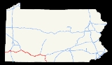
runs east–west across the southwest part of the state serving the southern half of the Pittsburgh metropolitan area. About half of the route is concurrent with Interstate 76
along the Pennsylvania Turnpike
(this is the oldest segment of I-70 in Pennsylvania, having been completed in 1940). I-70 is one of only a few Interstate Highways to have a traffic signal - in this case, with U.S. Route 30 at Breezewood, where it leaves the Turnpike and heads south towards Maryland
.
The portion of I-70 between Washington, Pennsylvania
(immediately after it ends its brief concurrency
with Interstate 79
) and New Stanton, Pennsylvania
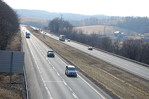
falls well below modern Interstate Highway standards
. This section, among other things, employs a jersey barrier
in the very narrow median as well as very short entrance ramps at several interchanges, requiring a stop sign
to be employed at these ramps instead of the typical yield sign
. As the Pennsylvania Turnpike
is grandfathered
from Interstate standards as well as the aforementioned traffic signal in Breezewood, this makes the majority of I-70 not up to standards, with the short section south of Breezewood to Maryland
as well as the 21-mile section from I-79 to West Virginia
being the only sections of I-70 in Pennsylvania being up to Interstate standards.
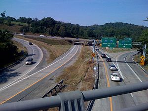
I-70 crosses the Monongahela River
on the Speers-Belle Vernon Bridge and the Youghiogheny River
on the Smithton High Level Bridge.
. The route from West Virginia
split at Washington, with one branch heading northeast to meet the Pennsylvania Turnpike
near Pittsburgh and the other heading east, bypassing Pittsburgh to the south (via a planned bypass of Pennsylvania Route 71
) to the New Stanton interchange
. The piece south from the Breezewood interchange into Maryland
was also in the network. The route between US 30 in Breezewood and US 522 in Warfordsburg was originally known as Pennsylvania Route 126. In 1957, preliminary numbers were assigned; the longer route via Pittsburgh (now Interstate 79 and Interstate 376
) became the main line of I-70, while the southern bypass (now I-70) became Interstate 70S. A southern extension of Interstate 79
(which had previously only run from Erie south to Pittsburgh) to Charleston, West Virginia
in 1963 resulted in changes to I-70. On February 26, 1964, as part of the formation of Interstate 76
(east of downtown Pittsburgh), AASHTO approved a rerouting of I-70 along I-70S. The former I-70 became I-79 from Washington to downtown Pittsburgh and I-76 to and along the Turnpike to New Stanton. This brought the routing of I-70 to its present form.
U.S. state
A U.S. state is any one of the 50 federated states of the United States of America that share sovereignty with the federal government. Because of this shared sovereignty, an American is a citizen both of the federal entity and of his or her state of domicile. Four states use the official title of...
of Pennsylvania
Pennsylvania
The Commonwealth of Pennsylvania is a U.S. state that is located in the Northeastern and Mid-Atlantic regions of the United States. The state borders Delaware and Maryland to the south, West Virginia to the southwest, Ohio to the west, New York and Ontario, Canada, to the north, and New Jersey to...
, Interstate 70
Interstate 70
Interstate 70 is an Interstate Highway in the United States that runs from Interstate 15 near Cove Fort, Utah, to a Park and Ride near Baltimore, Maryland. It was the first Interstate Highway project in the United States. I-70 approximately traces the path of U.S. Route 40 east of the Rocky...
runs east–west across the southwest part of the state serving the southern half of the Pittsburgh metropolitan area. About half of the route is concurrent with Interstate 76
Interstate 76 (east)
Interstate 76 is an Interstate Highway in the United States, running 435 miles from an interchange with Interstate 71 west of Akron, Ohio, east to Interstate 295 near Camden, New Jersey....
along the Pennsylvania Turnpike
Pennsylvania Turnpike
The Pennsylvania Turnpike is a toll highway system operated by the Pennsylvania Turnpike Commission in the Commonwealth of Pennsylvania, United States. The three sections of the turnpike system total . The main section extends from Ohio to New Jersey and is long...
(this is the oldest segment of I-70 in Pennsylvania, having been completed in 1940). I-70 is one of only a few Interstate Highways to have a traffic signal - in this case, with U.S. Route 30 at Breezewood, where it leaves the Turnpike and heads south towards Maryland
Maryland
Maryland is a U.S. state located in the Mid Atlantic region of the United States, bordering Virginia, West Virginia, and the District of Columbia to its south and west; Pennsylvania to its north; and Delaware to its east...
.
The portion of I-70 between Washington, Pennsylvania
Washington, Pennsylvania
Washington is a city in and the county seat of Washington County, Pennsylvania, United States, within the Pittsburgh Metro Area in the southwestern part of the state...
(immediately after it ends its brief concurrency
Concurrency (road)
A concurrency, overlap, or coincidence in a road network is an instance of one physical road bearing two or more different highway, motorway, or other route numbers...
with Interstate 79
Interstate 79
Interstate 79 is an Interstate Highway in the eastern United States, designated from Interstate 77 in Charleston, West Virginia to Pennsylvania Route 5 and Pennsylvania Route 290 in Erie, Pennsylvania...
) and New Stanton, Pennsylvania
New Stanton, Pennsylvania
New Stanton is a borough in Westmoreland County, Pennsylvania, United States. The population was 1,906 at the 2000 census. New Stanton is often used as a control city in western parts of Pennsylvania, as I-70 joins the Pennsylvania Turnpike eastbound towards Breezewood, Pennsylvania in New...
falls well below modern Interstate Highway standards
Interstate Highway standards
Standards for Interstate Highways in the United States are defined by the American Association of State Highway and Transportation Officials in the publication A Policy on Design Standards - Interstate System...
. This section, among other things, employs a jersey barrier
Jersey barrier
A Jersey barrier or Jersey wall is a modular concrete barrier employed to separate lanes of traffic. It is designed to both minimize vehicle damage in cases of incidental contact while still preventing crossover in the case of head-on accidents....
in the very narrow median as well as very short entrance ramps at several interchanges, requiring a stop sign
Stop sign
A Stop sign is a traffic sign to notify drivers that they must stop before proceeding.-Specifications:The Vienna Convention on Road Signs and Signals proposed standard stop sign diameters of 0.6, 0.9 or 1.2 metres. UK and New Zealand stop signs are 750, 900 or 1200 mm, according to sign...
to be employed at these ramps instead of the typical yield sign
Yield sign
In road transport, a ' or ' traffic sign indicates that each driver must prepare to stop if necessary to let a driver on another approach proceed. A driver who stops has yielded the right of way to another...
. As the Pennsylvania Turnpike
Pennsylvania Turnpike
The Pennsylvania Turnpike is a toll highway system operated by the Pennsylvania Turnpike Commission in the Commonwealth of Pennsylvania, United States. The three sections of the turnpike system total . The main section extends from Ohio to New Jersey and is long...
is grandfathered
Grandfather clause
Grandfather clause is a legal term used to describe a situation in which an old rule continues to apply to some existing situations, while a new rule will apply to all future situations. It is often used as a verb: to grandfather means to grant such an exemption...
from Interstate standards as well as the aforementioned traffic signal in Breezewood, this makes the majority of I-70 not up to standards, with the short section south of Breezewood to Maryland
Maryland
Maryland is a U.S. state located in the Mid Atlantic region of the United States, bordering Virginia, West Virginia, and the District of Columbia to its south and west; Pennsylvania to its north; and Delaware to its east...
as well as the 21-mile section from I-79 to West Virginia
West Virginia
West Virginia is a state in the Appalachian and Southeastern regions of the United States, bordered by Virginia to the southeast, Kentucky to the southwest, Ohio to the northwest, Pennsylvania to the northeast and Maryland to the east...
being the only sections of I-70 in Pennsylvania being up to Interstate standards.
I-70 crosses the Monongahela River
Monongahela River
The Monongahela River is a river on the Allegheny Plateau in north-central West Virginia and southwestern Pennsylvania in the United States...
on the Speers-Belle Vernon Bridge and the Youghiogheny River
Youghiogheny River
The Youghiogheny River , or the Yough for short, is a tributary of the Monongahela River in the U.S. states of West Virginia, Maryland, and Pennsylvania...
on the Smithton High Level Bridge.
History
By 1947, present Interstate 70 across Pennsylvania was included in the planned Interstate Highway SystemInterstate Highway System
The Dwight D. Eisenhower National System of Interstate and Defense Highways, , is a network of limited-access roads including freeways, highways, and expressways forming part of the National Highway System of the United States of America...
. The route from West Virginia
West Virginia
West Virginia is a state in the Appalachian and Southeastern regions of the United States, bordered by Virginia to the southeast, Kentucky to the southwest, Ohio to the northwest, Pennsylvania to the northeast and Maryland to the east...
split at Washington, with one branch heading northeast to meet the Pennsylvania Turnpike
Pennsylvania Turnpike
The Pennsylvania Turnpike is a toll highway system operated by the Pennsylvania Turnpike Commission in the Commonwealth of Pennsylvania, United States. The three sections of the turnpike system total . The main section extends from Ohio to New Jersey and is long...
near Pittsburgh and the other heading east, bypassing Pittsburgh to the south (via a planned bypass of Pennsylvania Route 71
Pennsylvania Route 71
Pennsylvania Route 71 was a state highway in the U.S. state of Pennsylvania, serving the Washington-Greensburg corridor that Interstate 70 now serves. The western terminus of the route was at U.S. Route 40 in North Bethlehem Township. The eastern terminus was at U.S...
) to the New Stanton interchange
Interchange (road)
In the field of road transport, an interchange is a road junction that typically uses grade separation, and one or more ramps, to permit traffic on at least one highway to pass through the junction without directly crossing any other traffic stream. It differs from a standard intersection, at which...
. The piece south from the Breezewood interchange into Maryland
Maryland
Maryland is a U.S. state located in the Mid Atlantic region of the United States, bordering Virginia, West Virginia, and the District of Columbia to its south and west; Pennsylvania to its north; and Delaware to its east...
was also in the network. The route between US 30 in Breezewood and US 522 in Warfordsburg was originally known as Pennsylvania Route 126. In 1957, preliminary numbers were assigned; the longer route via Pittsburgh (now Interstate 79 and Interstate 376
Interstate 376
Interstate 376 is a major auxiliary route of the Interstate Highway System in the U.S. state of Pennsylvania, located entirely within the Allegheny Plateau. It runs from I-80 near Sharon south and east to a junction with the Pennsylvania Turnpike in Monroeville, after having crossed the Turnpike...
) became the main line of I-70, while the southern bypass (now I-70) became Interstate 70S. A southern extension of Interstate 79
Interstate 79
Interstate 79 is an Interstate Highway in the eastern United States, designated from Interstate 77 in Charleston, West Virginia to Pennsylvania Route 5 and Pennsylvania Route 290 in Erie, Pennsylvania...
(which had previously only run from Erie south to Pittsburgh) to Charleston, West Virginia
Charleston, West Virginia
Charleston is the capital and largest city of the U.S. state of West Virginia. It is located at the confluence of the Elk and Kanawha Rivers in Kanawha County. As of the 2010 census, it has a population of 51,400, and its metropolitan area 304,214. It is the county seat of Kanawha County.Early...
in 1963 resulted in changes to I-70. On February 26, 1964, as part of the formation of Interstate 76
Interstate 76 (east)
Interstate 76 is an Interstate Highway in the United States, running 435 miles from an interchange with Interstate 71 west of Akron, Ohio, east to Interstate 295 near Camden, New Jersey....
(east of downtown Pittsburgh), AASHTO approved a rerouting of I-70 along I-70S. The former I-70 became I-79 from Washington to downtown Pittsburgh and I-76 to and along the Turnpike to New Stanton. This brought the routing of I-70 to its present form.
Exit list
| County | Location | Mile | Exit Exit number An exit number is a number assigned to a road junction, usually an exit from a freeway. It is usually marked on the same sign as the destinations of the exit, as well as a sign in the gore.... |
Destinations | Notes |
|---|---|---|---|---|---|
| Washington Washington County, Pennsylvania -Government and politics:As of November 2008, there are 152,534 registered voters in Washington County .* Democratic: 89,027 * Republican: 49,025 * Other Parties: 14,482... |
Donegal Township Donegal Township, Washington County, Pennsylvania Donegal Township is a township in Washington County, Pennsylvania, United States. The population was 2,428 at the 2000 census.-Geography:According to the United States Census Bureau, the township has a total area of , of which, of it is land and of it is water.-Demographics:As of the census of... |
0.89 | 1 | West Alexander West Alexander, Pennsylvania West Alexander is an unincorporated community in Washington County, Pennsylvania, United States. The population was 320 at the 2000 census, at which time it was a borough... |
|
| 5.65 | 6 | ||||
| Buffalo Township Buffalo Township, Washington County, Pennsylvania Buffalo Township is a township in Washington County, Pennsylvania, United States. The population was 2,100 at the 2000 census.-Geography:According to the United States Census Bureau, the township has a total area of , of which, of it is land and 0.05% is water.-Demographics:As of the census of... |
11.00 | 11 | |||
| North Franklin Township North Franklin Township, Pennsylvania North Franklin Township is a township in Washington County, Pennsylvania, United States. The population was 4,818 at the 2000 census.-Geography:... |
14.81 | 15 | |||
| Canton Township Canton Township, Washington County, Pennsylvania Canton Township is a township in Washington County, Pennsylvania, United States. The population was 8,826 at the 2000 census.-Geography:According to the United States Census Bureau, the township has a total area of , all of it land.-Demographics:... |
15.96 | 16 | Jessop Place | ||
| Washington Washington, Pennsylvania Washington is a city in and the county seat of Washington County, Pennsylvania, United States, within the Pittsburgh Metro Area in the southwestern part of the state... |
16.65 | 17 | |||
| South Strabane Township South Strabane Township, Pennsylvania South Strabane Township is a township in Washington County, Pennsylvania, United States. The population was 9,346 at the 2000 census. The township is named after the town of Strabane in County Tyrone, Northern Ireland.-Geography:... |
17.51 | 18 | West end of I-79 overlap | ||
| 18.56 | 19 | Signed as exits 19A (south) and 19B (north) | |||
| 19.00 | 20 | ||||
| 21.02 | 21 | – Morgantown | East end of I-79 overlap | ||
| Somerset Township Somerset Township, Washington County, Pennsylvania Somerset Township is a township in Washington County, Pennsylvania, United States. The population was 2,701 at the 2000 census.-Geography:... |
24.50 | 25 | |||
| 27.42 | 27 | Dunningsville | |||
| 30.50 | 31 | Kammerer | |||
| 32.54 | 32A | ||||
| Bentleyville Bentleyville, Pennsylvania Bentleyville is a borough in Washington County, Pennsylvania, United States. The population was 2,502 at the 2000 census.-Geography:Bentleyville is located at . U.S... |
32.94 | 32B | |||
| Fallowfield Township Fallowfield Township, Pennsylvania Fallowfield Township is a township in Washington County, Pennsylvania, United States. The population was 4,461 at the 2000 census.-Geography:... |
35.03 | 35 | |||
| 36.43 | 36 | Lover | Westbound exit and eastbound entrance | ||
| 37.46 | 37 | Signed as exits 37A (south) and 37B (north) | |||
| Speers Speers, Pennsylvania Speers is a borough in Washington County, Pennsylvania, United States. The population was 1,241 at the 2000 census.-Geography:According to the United States Census Bureau, the borough of Speers has a total area of , of which, of it is land and of it is water.-Demographics:As of the census of... |
39.74 | 39 | Speers | ||
| 40.19 | 40 | ||||
| Westmoreland Westmoreland County, Pennsylvania -Demographics:As of the census of 2000, there were 369,993 people, 149,813 households, and 104,569 families residing in the county. The population density was 361 people per square mile . There were 161,058 housing units at an average density of 157 per square mile... |
Rostraver Township Rostraver Township, Pennsylvania Rostraver Township is a township in Westmoreland County, Pennsylvania, United States. The population was 11,634 at the 2000 census.-History:Rostraver Township is the location of the Household No. 1 Site, which was once occupied by a Monongahela village.... |
40.72 | 41 | ||
| North Belle Vernon North Belle Vernon, Pennsylvania North Belle Vernon is a borough in Westmoreland County, Pennsylvania, United States. The population was 2,107 at the 2000 census.-Geography:North Belle Vernon is located at .... |
41.46 | 42 | North Belle Vernon | ||
| Rostraver Township Rostraver Township, Pennsylvania Rostraver Township is a township in Westmoreland County, Pennsylvania, United States. The population was 11,634 at the 2000 census.-History:Rostraver Township is the location of the Household No. 1 Site, which was once occupied by a Monongahela village.... |
42.13 | 42A | Monessen | Westbound exit and eastbound entrance | |
| 42.64 | 43 | Signed as exits 43A (south) and 43B (north) westbound | |||
| 44.10 | 44 | Arnold City | |||
| 46.36 | 46 | Signed as exits 46A (south) and 46B (north) | |||
| South Huntingdon Township South Huntingdon Township, Pennsylvania South Huntingdon Township is a township in Westmoreland County, Pennsylvania, United States. The population was 6,175 at the 2000 census.-Geography:... |
48.85 | 49 | Smithton Smithton, Pennsylvania Smithton is a borough in Westmoreland County, Pennsylvania, United States. The population was 444 at the 2000 census.Smithton's early industry was in coal mining, coke ovens, and shipping goods produced in the valley of Jacobs Creek.... |
||
| 51.13 | 51 | Signed as exits 51A (east) and 51B (west) | |||
| 53.19 | 53 | Yukon | |||
| Sewickley Township Sewickley Township, Pennsylvania Sewickley Township is a township in Westmoreland County, Pennsylvania, United States. The population was 6,230 at the 2000 census.-Geography:... |
53.82 | 54 | Madison Madison, Pennsylvania Madison is a borough in Westmoreland County, Pennsylvania, United States. The population was 510 at the 2000 census.-Geography:Madison is located at .... |
||
| New Stanton New Stanton, Pennsylvania New Stanton is a borough in Westmoreland County, Pennsylvania, United States. The population was 1,906 at the 2000 census. New Stanton is often used as a control city in western parts of Pennsylvania, as I-70 joins the Pennsylvania Turnpike eastbound towards Breezewood, Pennsylvania in New... |
56.87 | 57A | Hunker Hunker, Pennsylvania Hunker is a borough in Westmoreland County, Pennsylvania, United States. The population was 329 at the 2000 census.-Geography:Hunker is located at .... |
Westbound exit and eastbound entrance | |
| 56.95 | 57B | New Stanton | Signed as exit 57 eastbound | ||
| 57.32 | |||||
| , Cleveland | West end of I-76 overlap | ||||
| Donegal | 91 | ||||
| Somerset | Somerset | 110 | |||
| Bedford Bedford County, Pennsylvania Bedford County is a county located in the U.S. state of Pennsylvania. As of the 2010 census, the population was 49,762. The county seat is Bedford. It is part of the Altoona, Pennsylvania, Metropolitan Statistical Area.- History :... |
Bedford | 146 | |||
| East Providence Township East Providence Township, Pennsylvania East Providence Township is a township in Bedford County, Pennsylvania in the United States of America. The population was 1,858 at the 2000 census... |
161 | East end of I-76 overlap | |||
| East end of freeway | |||||
| West end of US 30 overlap | |||||
| 147.05 | 147 | East end of US 30 overlap; at-grade intersection At-grade intersection An at-grade intersection is a junction at which two or more transport axes cross at the same level .-Traffic management:With areas of high or fast traffic, an at-grade intersection normally requires a traffic control device such as a stop sign, traffic light or railway signal to manage conflicting... |
|||
| West end of freeway | |||||
| Fulton Fulton County, Pennsylvania Fulton County is a county located in the U.S. state of Pennsylvania. As of 2010, the population was 14,845.Fulton County was created on April 19, 1850, from part of Bedford County and named for inventor Robert Fulton.Its county seat is McConnellsburg.... |
148.68 | 149 | No westbound entrance | ||
| Brush Creek Township Brush Creek Township, Pennsylvania Brush Creek Township is a township in Fulton County, Pennsylvania, United States. The population was 730 at the 2000 census.-Geography:According to the United States Census Bureau, the township has a total area of , all of it land.-Demographics:... |
151.16 | 151 | |||
| 155.75 | 156 | ||||
| Union Township Union Township, Fulton County, Pennsylvania Union Township is a township located in Fulton County, Pennsylvania. As of the 2000 census, the township had a total population of 634.-Geography:... |
163.21 | 163 | |||
| Bethel Township Bethel Township, Fulton County, Pennsylvania Bethel Township is a township in Fulton County, Pennsylvania, United States. The population was 1,420 at the 2000 census.-Geography:According to the United States Census Bureau, the township has a total area of , of which, of it is land and 0.03% is water.-Demographics:As of the census of 2000,... |
167.93 | 168 | West end of US 522 overlap | ||