
.gif)
Interstate 480 (Iowa-Nebraska)
Encyclopedia
Interstate 480 is an auxiliary Interstate Highway, a mere 5 miles (8 km) long, that connects Interstate 80
in downtown Omaha, Nebraska
, with Interstate 29
in Council Bluffs, Iowa
. The portion of I-480 in Nebraska
has been named the Gerald R. Ford Freeway, named in honor of the former President, who was a native of Omaha. For most of its length, I-480 is overlapped
by a U.S. Highway; for 2 miles (3.2 km) with U.S. Route 75 and for 1 miles (1.6 km) with U.S. Route 6
. Interstate 480 includes the Grenville Dodge Memorial Bridge over the Missouri River
.
with Interstate 80 to the east and west and with U.S. Route 75, known as the Kennedy Freeway, to the south. Going north, I-480 passes the Hanscom Park
neighborhood to the west and the Vinton Street Commercial Historic District
to the east. At exit 1A, I-480 intersects Martha Street, which before January 1, 2003, was the eastern end of Nebraska Highway 38. North of Martha Street, I-480 passes the Gerald R. Ford Birthsite and Gardens
. At the Leavenworth Street exit, the highway divides the Leavenworth neighborhood from the Old Market neighborhood. Shortly after the Leavenworth Street exit is the Harney Street exit, which provides access to U.S. Route 6 from eastbound I-480. before the North Freeway interchange, I-480 passes beneath Dodge and Douglas Streets, which are the westbound and eastbound lanes of U.S. 6, respectively.
 Just to the southwest of the Creighton University
campus is the North Freeway
interchange, where US 75 leaves eastbound I-480 and joins westbound. The North Freeway was originally planned to be an Interstate Highway, "I-580", connecting northern Omaha to downtown, but this project was canceled with the interchange in midst of construction. A number of so-called ghost ramp
s can be found, but these are being eliminated during the reconstruction of this interchange. Here, I-480 turns to the east towards Council Bluffs, Iowa
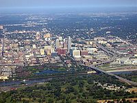
. I-480 passes between the NoDo and Downtown Omaha
neighborhoods. Farther east, it dips to the southeast near Qwest Center Omaha
, part of the "NoDo" neighborhood. Immediately before crossing the Missouri River
, U.S. Route 6 joins I-480 to cross into Iowa. This bridge over the Missouri River was constructed in 1965 - 66 to replace the old Ak-Sar-Ben Bridge
which had been the first highway bridge across the river in this area.
Upon entering Council Bluffs
, I-480 meets up with Interstate 29
3/4 mi from the Missouri River. On the other side of this interchange, I-480 ends where U.S. 6 traffic encounters signal-controlled intersections.
 In the late 1950s the construction of what was then referred to as Route 3 was highly controversial. It conveniently crossed through the western and northern edges of Downtown Omaha
, two areas city leaders had considered "blighted" since the 1930s. The heavily Catholic, ethnic European neighborhoods the route went through rallied against the demolition of their homes, and the city's parks advocates provided resistance as well. Eventually the Interstate planners won out, and the city's historic Jefferson Square
was demolished, as well as dozens of homes along the route.
In 1999, a bill was introduced in the United States House of Representatives
that would have extended I-480 south along U.S. Highway 75 in southern Omaha and in Bellevue, Nebraska
, then east through Plattsmouth to connect with Interstate 29
near Glenwood, Iowa
, increasing the length of Interstate 480 to 19 miles (30.6 km). However, this bill was tabled in the committee.
began a project to bring the I-480 / U.S. 75 interchange up to Interstate Highway standards. Construction work on this was expected to be completed by 2009, but it has been delayed to 2011 due to shortage of funding.
Interstate 80
Interstate 80 is the second-longest Interstate Highway in the United States, following Interstate 90. It is a transcontinental artery running from downtown San Francisco, California to Teaneck, New Jersey in the New York City Metropolitan Area...
in downtown Omaha, Nebraska
Omaha, Nebraska
Omaha is the largest city in the state of Nebraska, United States, and is the county seat of Douglas County. It is located in the Midwestern United States on the Missouri River, about 20 miles north of the mouth of the Platte River...
, with Interstate 29
Interstate 29
Interstate 29 is an Interstate Highway in the Midwestern United States. I-29 runs from Kansas City, Missouri, at a junction with Interstate 35 and Interstate 70 to the Canadian border near Pembina, North Dakota, where it connects with Manitoba Highway 75 via the short Manitoba Highway 29.-Route...
in Council Bluffs, Iowa
Council Bluffs, Iowa
Council Bluffs, known until 1852 as Kanesville, Iowathe historic starting point of the Mormon Trail and eventual northernmost anchor town of the other emigrant trailsis a city in and the county seat of Pottawattamie County, Iowa, United States and is on the east bank of the Missouri River across...
. The portion of I-480 in Nebraska
Nebraska
Nebraska is a state on the Great Plains of the Midwestern United States. The state's capital is Lincoln and its largest city is Omaha, on the Missouri River....
has been named the Gerald R. Ford Freeway, named in honor of the former President, who was a native of Omaha. For most of its length, I-480 is overlapped
Concurrency (road)
A concurrency, overlap, or coincidence in a road network is an instance of one physical road bearing two or more different highway, motorway, or other route numbers...
by a U.S. Highway; for 2 miles (3.2 km) with U.S. Route 75 and for 1 miles (1.6 km) with U.S. Route 6
U.S. Route 6
U.S. Route 6 , also called the Grand Army of the Republic Highway, a name that honors an American Civil War veterans association, is a main route of the U.S. Highway system, running east-northeast from Bishop, California to Provincetown, Massachusetts. Until 1964, it continued south from Bishop to...
. Interstate 480 includes the Grenville Dodge Memorial Bridge over the Missouri River
Missouri River
The Missouri River flows through the central United States, and is a tributary of the Mississippi River. It is the longest river in North America and drains the third largest area, though only the thirteenth largest by discharge. The Missouri's watershed encompasses most of the American Great...
.
Route description
Interstate 480 begins at an interchangeInterchange (road)
In the field of road transport, an interchange is a road junction that typically uses grade separation, and one or more ramps, to permit traffic on at least one highway to pass through the junction without directly crossing any other traffic stream. It differs from a standard intersection, at which...
with Interstate 80 to the east and west and with U.S. Route 75, known as the Kennedy Freeway, to the south. Going north, I-480 passes the Hanscom Park
Hanscom Park
Hanscom Park is a historic neighborhood in Midtown Omaha, Nebraska. Its namesake public park is one of the oldest parks in Omaha, donated to the City in 1872. U.S. President Gerald R. Ford was born in a house in the Hanscom Park neighborhood...
neighborhood to the west and the Vinton Street Commercial Historic District
Vinton Street Commercial Historic District
The Vinton Street Commercial Historic District is located along Vinton Street between Elm Street on the west and South 17th Street on the east in south Omaha, Nebraska. This district is located within Sheelytown, a residential neighborhood that had historically significant populations of Irish,...
to the east. At exit 1A, I-480 intersects Martha Street, which before January 1, 2003, was the eastern end of Nebraska Highway 38. North of Martha Street, I-480 passes the Gerald R. Ford Birthsite and Gardens
Gerald R. Ford Birthsite and Gardens
The Gerald R. Ford Birthsite and Gardens in Omaha, Nebraska marks the location of the house at 3202 Woolworth Avenue where U.S. President Gerald R. Ford lived for a couple of weeks after his birth in July 1913...
. At the Leavenworth Street exit, the highway divides the Leavenworth neighborhood from the Old Market neighborhood. Shortly after the Leavenworth Street exit is the Harney Street exit, which provides access to U.S. Route 6 from eastbound I-480. before the North Freeway interchange, I-480 passes beneath Dodge and Douglas Streets, which are the westbound and eastbound lanes of U.S. 6, respectively.
Creighton University
Creighton University is a private, coeducational, Jesuit, Roman Catholic university located in Omaha, Nebraska, United States. Founded by the Society of Jesus in 1878, the school is one of 28 member institutions of the Association of Jesuit Colleges and Universities. The university is accredited by...
campus is the North Freeway
North Freeway
North Freeway may refer to:*North Freeway *North Freeway *North Freeway...
interchange, where US 75 leaves eastbound I-480 and joins westbound. The North Freeway was originally planned to be an Interstate Highway, "I-580", connecting northern Omaha to downtown, but this project was canceled with the interchange in midst of construction. A number of so-called ghost ramp
Ghost ramp
An unused highway may reference a highway or highway ramp that was partially or fully constructed but was unused or later closed. An unused ramp can be referred to as a stub ramp, stub street, stub-out, or simply stub. The following is a list:-External links:* - photographic essay of Baltimore area...
s can be found, but these are being eliminated during the reconstruction of this interchange. Here, I-480 turns to the east towards Council Bluffs, Iowa
Council Bluffs, Iowa
Council Bluffs, known until 1852 as Kanesville, Iowathe historic starting point of the Mormon Trail and eventual northernmost anchor town of the other emigrant trailsis a city in and the county seat of Pottawattamie County, Iowa, United States and is on the east bank of the Missouri River across...
. I-480 passes between the NoDo and Downtown Omaha
Downtown Omaha
Downtown Omaha is the central business, government and social core of the Omaha-Council Bluffs metropolitan area, and is located in Omaha, Nebraska. The boundaries are 20th Street on the west to the Missouri River on the east and the centerline of Leavenworth Street on the south to the centerline...
neighborhoods. Farther east, it dips to the southeast near Qwest Center Omaha
Qwest Center Omaha
CenturyLink Center is an arena and convention center facility in the North Downtown neighborhood in Omaha, Nebraska. The 1.1 million ft² facility has an 18,300-seat arena, a 194,000-ft² exhibition hall and 62,000 ft² of meeting space....
, part of the "NoDo" neighborhood. Immediately before crossing the Missouri River
Missouri River
The Missouri River flows through the central United States, and is a tributary of the Mississippi River. It is the longest river in North America and drains the third largest area, though only the thirteenth largest by discharge. The Missouri's watershed encompasses most of the American Great...
, U.S. Route 6 joins I-480 to cross into Iowa. This bridge over the Missouri River was constructed in 1965 - 66 to replace the old Ak-Sar-Ben Bridge
Ak-Sar-Ben Bridge
The Ak-Sar-Ben Bridge was a truss bridge that was the first road bridge to cross the Missouri River connecting Omaha, Nebraska and Council Bluffs, Iowa...
which had been the first highway bridge across the river in this area.
Upon entering Council Bluffs
Council Bluffs, Iowa
Council Bluffs, known until 1852 as Kanesville, Iowathe historic starting point of the Mormon Trail and eventual northernmost anchor town of the other emigrant trailsis a city in and the county seat of Pottawattamie County, Iowa, United States and is on the east bank of the Missouri River across...
, I-480 meets up with Interstate 29
Interstate 29
Interstate 29 is an Interstate Highway in the Midwestern United States. I-29 runs from Kansas City, Missouri, at a junction with Interstate 35 and Interstate 70 to the Canadian border near Pembina, North Dakota, where it connects with Manitoba Highway 75 via the short Manitoba Highway 29.-Route...
3/4 mi from the Missouri River. On the other side of this interchange, I-480 ends where U.S. 6 traffic encounters signal-controlled intersections.
History
Downtown Omaha
Downtown Omaha is the central business, government and social core of the Omaha-Council Bluffs metropolitan area, and is located in Omaha, Nebraska. The boundaries are 20th Street on the west to the Missouri River on the east and the centerline of Leavenworth Street on the south to the centerline...
, two areas city leaders had considered "blighted" since the 1930s. The heavily Catholic, ethnic European neighborhoods the route went through rallied against the demolition of their homes, and the city's parks advocates provided resistance as well. Eventually the Interstate planners won out, and the city's historic Jefferson Square
Jefferson Square (Omaha)
Jefferson Square was the last of three original public parks extant in Omaha, Nebraska. Bounded by North 15th, 16th, Chicago and Cass Streets, the park was dedicated November 25, 1865. It was razed by the city March 18, 1969 to make way for the construction of Interstate 480 in Downtown Omaha...
was demolished, as well as dozens of homes along the route.
In 1999, a bill was introduced in the United States House of Representatives
United States House of Representatives
The United States House of Representatives is one of the two Houses of the United States Congress, the bicameral legislature which also includes the Senate.The composition and powers of the House are established in Article One of the Constitution...
that would have extended I-480 south along U.S. Highway 75 in southern Omaha and in Bellevue, Nebraska
Bellevue, Nebraska
Bellevue is a city in Sarpy County, Nebraska, United States. The population was 50,137 at the 2010 census. Eight miles south of Omaha, Bellevue is part of the Omaha-Council Bluffs metropolitan area. Originally settled in the 1830s, It was the first state capitol. Bellevue was incorporated in...
, then east through Plattsmouth to connect with Interstate 29
Interstate 29
Interstate 29 is an Interstate Highway in the Midwestern United States. I-29 runs from Kansas City, Missouri, at a junction with Interstate 35 and Interstate 70 to the Canadian border near Pembina, North Dakota, where it connects with Manitoba Highway 75 via the short Manitoba Highway 29.-Route...
near Glenwood, Iowa
Glenwood, Iowa
Glenwood is a city in and the county seat of Mills County, Iowa, United States. The population was 5,269 in the 2010 census, a decline from 5,358 in the 2000 census. -History:...
, increasing the length of Interstate 480 to 19 miles (30.6 km). However, this bill was tabled in the committee.
Future
In 2005, the Nebraska Department of RoadsNebraska Department of Roads
The Nebraska Department of Roads is the state government agency charged with building and maintaining the state and federal highways in the U.S. state of Nebraska. The main headquarters of the agency is located in Lincoln, the capital city...
began a project to bring the I-480 / U.S. 75 interchange up to Interstate Highway standards. Construction work on this was expected to be completed by 2009, but it has been delayed to 2011 due to shortage of funding.