
.gif)
Interstate 215 (Utah)
Encyclopedia
Interstate 215 also known locally as the belt route or two-fifteen, is an auxiliary interstate in the U.S. state
of Utah
that forms a 270-degree loop around Salt Lake City and many of its suburbs. The route begins at the mouth of Parley's Canyon
at the junction of I-80 and heads south through the edge of the Salt Lake City metropolitan area
's eastern suburbs of East Millcreek
, Holladay
, and Cottonwood Heights
. It continues west through Murray
before turning north again, passing through the city's first-ring western suburbs of Taylorsville
and West Valley City
. It then enters North Salt Lake
and Davis County
for a short distance before defaulting onto I-15.
The interstate was proposed in the mid-1950s, along with the I-15 and I-80 through Salt Lake City. At the time, only the western portion of the belt route was given to I-215. The eastern portion of the belt route was designated Interstate 415. However, the I-415 designation was scrapped to provide a single route number for the entire route in 1969, with the I-215 designation covering the complete belt route. The freeway was constructed in segments, beginning with a section completed in 1963 from Redwood Road in North Salt Lake to 2100 North near the airport
. Originally planned to be complete in the mid-1970s, challenges from citizens' groups over environmental impact statements led to the completion of the last section of I-215 in 1989 between 6200 South in Knudsen's Corner and 4500 South in Holladay.
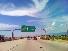
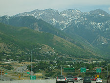
at the southeast corner of Salt Lake City that connects I-80, Foothill Drive (State Route 186, or SR-186) and Parleys Way. At this point, I-215 splits into three legs, connecting I-80 toward Salt Lake City, Foothill Drive and Parleys Way, and I-80 through Parley's Canyon. From here, the freeway travels southeast along the Salt Lake Valley
's east bench with three lanes in each direction. The route enters a residential area of East Millcreek
and turns south. Then, the first exit appears, an incomplete diamond interchange
with 3300 South (SR-171) that is missing an off-ramp from northbound I-215. Past this interchange, an on-ramp connects 3800 South to northbound I-215. A block further south is a partial interchange lacking an off-ramp from northbound I-215 onto 3900 South. Entering Holladay
, I-215 is heading south but soon turns southwest. An off-ramp here allows northbound motorists to connect to Wasatch Boulevard. However, this exit is signed as 3900 South and 3300 South because of the incomplete interchanges on both roads. Past an interchange at 4500 South (SR-266) that serves southbound I-215, the road turns south again and begins descending toward Knudsen's Corner and Cottonwood Heights
. At this point, the southbound lanes are lower than the parallel northbound lanes. The belt route flattens out upon reaching an interchange at 6200 South at Knudsen's Corner.
 As the freeway enters Cottonwood Heights, it turns west and becomes a sunken freeway. Then, it reaches an interchange at 2000 East (SR-152) This interchange features a grade-separated ramp from northbound 2000 East to eastbound I-215. Past this junction, another interchange at Union Park Avenue appears. Another grade-separated ramp from Union Park Avenue is present. The road enters Murray as an interchange serving westbound motorists connects 280 East and State Street (U.S. Route 89
, or US-89). Eastbound travelers connect to State Street further west at a separate exit. The road turns northwest for a short time to approach a junction at I-15. Approaching the interchange, the route gains two lanes and reverts to a ground-level freeway. The freeway crosses I-15 and loses one lane as it enters Taylorsville
and curves to the northwest, crossing the Jordan River
in the process. Right before a partial cloverleaf interchange at Redwood Road (SR-68) the route turns west one final time before turning north after the interchange. The freeway continues north and has another partial cloverleaf interchange at 4700 South (SR-266). The route enters the populous West Valley City
suburb and encounters 3500 South (SR-171), where its eastbound lanes have a grade-separated ramp to northbound I-215. The road turns northeast and enters an industrial area of western Salt Lake City. After reaching a cloverleaf interchange
at SR-201, the route turns north again. Beyond a single-point urban interchange
at California Avenue, the freeway continues north.
A partial stack interchange
involving I-80, Redwood Road, and the access road to Salt Lake City International Airport
is next. The freeway loses one lane in each direction as the interstate passes the airport to the east. Two diamond interchanges at 700 North and 2100 North occur as the freeway approaches Davis County
. Past 2100 North, the freeway enters rural Salt Lake County
, and the road curves to the northwest. An interchange at Legacy Parkway
gives northbound I-215 motorists and southbound Legacy Parkway motorists their respective connections. The road turns east and loses one lane in each direction. There is a diamond interchange
at SR-68 before the road defaults onto northbound I-15 south of North Salt Lake
.
 A belt route around Salt Lake City was first proposed in 1955, with the Utah Highway Department (the predecessor to the present-day Utah Department of Transportation
) holding hearings concerning construction beginning in early 1958. The southeast quadrant of the route was originally placed from a junction at proposed I-15 in Murray northeasterly through Murray and Holladay, eventually reaching the east bench at 3900 South. From there, it would have run north toward the mouth of Parley's Canyon at proposed I-80 (at the time US-40). Almost immediately, this plan was met with opposition among local residents in the area. The proposed route would have bisected the primarily residential Holladay suburb, as well as the southern portion of Murray. After more than two years of hearings and widespread opposition from residents, the Highway Department released their proposed routing in June 1960, which placed the southeast quadrant where it runs today. While quelling criticism from some, others remained in opposition, saying the route was still too intrusive along residential areas. The western quadrant was also admonished for being placed to close to other major arterials. In November 1963, a small, two-lane portion of the northwest quadrant of the belt route opened from Redwood Road (SR-68) in Davis County west and south to 2100 North, north of the Salt Lake City International Airport
. This portion of road was extended east to I-15 in North Salt Lake and upgraded to freeway standards by 1969.
Construction of the southeast quadrant from I-80 (at the time replacing US-40) at Parley's Canyon to 4600 South in Holladay began in mid-1965. This involved realigning Wasatch Boulevard to parallel the route and truncating that road at 3300 South. Prior to this, Wasatch Boulevard connected to US-40. The section from I-80 to 3300 South opened by January 1967, with the portion of roadway from 3300 South to 4500 South opening in November 1969.
By 1973, construction was progressing on the western quadrant between I-15 in Murray and SR-201 (at the time US-40A/US-50A). Land acquisition was also taking place for the rest of the southeastern quadrant between 300 East in Murray and 4600 South in Holladay. However, a citizens' group named Cottonwood Inc. halted right-of-way acquirements due to the lack of an environmental impact statement (EIS). Also controversial was a proposed cloverleaf interchange at 2000 East. By mid-1975, an EIS was released with four main alternatives: a no-build alternative which would leave a gap in the southeast quadrant, building the road along the modern-day path (at about 6400 South), moving the southern portion southwest through Fort Union and Midvale to 7200 South, or extending the eastern portion further south to Sandy and then west along 9000 South. Cottonwood Inc. filed a lawsuit challenging the EIS. Meanwhile, I-215 from SR-201 in the western quadrant to 280 East in Murray opened in November 1976.
After 1976, gaps in the belt route were present from 2100 North near the airport to SR-201 and from State Street in Murray to 4600 South in Holladay. The first step in completing the gap was taken in June 1979, when construction of the interstate from State Street to 700 East began. This was followed by the Cottonwood Inc. lawsuit being awarded in favor of UDOT in November 1979. In July 1985, the route from 280 East to Union Park Avenue was completed. At the time, this portion of road was the most expensive in the state in terms of cost per mile, due to the road being depressed below surrounding neighborhoods. The next section to open was from 2100 North south to I-80 in 1987. This was followed by a section between Union Park Avenue and 2000 East, opened in November 1987, which was also built as a sunken freeway. The western quadrant of the freeway was completed in October 1988, closing the gap between SR-201 and I-80 (however, the California Avenue interchange wasn't opened until mid-1989). In August 1989, the road from 2000 East to 6200 South was finished, and the belt route was completed with the opening of freeway between 4500 South and 6200 South in October 1989.
Since 1989, the only major modifications that have occurred on the belt route have consisted of the rebuilding of the southern I-15 interchange in 2001, widening from six to eight lanes from 4700 South in Taylorsville to I-15 in Murray in 2004, and the addition of an interchange at Legacy Parkway
in 2008. The 3300 South and 4500 South overpasses were rebuilt as well, in 2008 and 2007 respectively.
As part of the original proposal of a belt route through Salt Lake City, the southeastern quadrant received the designation of I-415. To maintain continuity in the belt route, the 415 number was replaced in favor of the I-215 designation covering the entire route in 1969.
U.S. state
A U.S. state is any one of the 50 federated states of the United States of America that share sovereignty with the federal government. Because of this shared sovereignty, an American is a citizen both of the federal entity and of his or her state of domicile. Four states use the official title of...
of Utah
Utah
Utah is a state in the Western United States. It was the 45th state to join the Union, on January 4, 1896. Approximately 80% of Utah's 2,763,885 people live along the Wasatch Front, centering on Salt Lake City. This leaves vast expanses of the state nearly uninhabited, making the population the...
that forms a 270-degree loop around Salt Lake City and many of its suburbs. The route begins at the mouth of Parley's Canyon
Parley's Canyon
Parley's Canyon is a canyon located in the U.S. state of Utah. The canyon provides the route of Interstate 80 up the western slope of the Wasatch Mountains and is a relatively wide, straight canyon. The lower part of the canyon, however, is relatively twisty and had to be dynamited to make way for...
at the junction of I-80 and heads south through the edge of the Salt Lake City metropolitan area
Salt Lake City metropolitan area
The Salt Lake City Metropolitan Statistical Area, as defined by the United States Census Bureau, is an area consisting of three counties in north central Utah, anchored by Salt Lake City. As of the 2000 census, the MSA had a population of 968,858. As of July 1, 2009 the U.S...
's eastern suburbs of East Millcreek
East Millcreek, Utah
East Millcreek was a census-designated place in Salt Lake County, Utah, United States, that has since been consolidated with neighboring Millcreek CDP. The population was 21,385 at the 2000 census, a minute increase over the 1990 figure of 21,184. It was originally proposed to be included in the...
, Holladay
Holladay, Utah
Holladay is a city in Salt Lake County, Utah, United States. It is part of the Salt Lake City, Utah Metropolitan Statistical Area. The population was 26,472 at the 2010 census, a significant increase from 14,561 in 2000. The city was incorporated on November 29, 1999 as Holladay-Cottonwood, and the...
, and Cottonwood Heights
Cottonwood Heights, Utah
Cottonwood Heights is a city located in Salt Lake County, Utah, United States, along the east bench of the Salt Lake Valley. It lies south of the cities of Holladay and Murray, east of Midvale, and north of Sandy within the Salt Lake City, Utah Metropolitan Statistical Area. Following a successful...
. It continues west through Murray
Murray, Utah
Murray is a city situated on the Wasatch Front in the core of Salt Lake Valley in the U.S. state of Utah. Named for territorial governor Eli Murray, it is the state's fourteenth largest city. According to the 2010 census, Murray has approximately 46,746 residents.Murray is close to Salt Lake City,...
before turning north again, passing through the city's first-ring western suburbs of Taylorsville
Taylorsville, Utah
Taylorsville is a city in Salt Lake County, Utah, United States. It is part of the Salt Lake City, Utah Metropolitan Statistical Area. The population was 57,439 at the 2000 census...
and West Valley City
West Valley City, Utah
West Valley City is a city in Salt Lake County and a suburb of Salt Lake City in the U.S. state of Utah. The population was 129,480 at the 2010 census,...
. It then enters North Salt Lake
North Salt Lake, Utah
North Salt Lake is a city in Davis County, Utah, United States. It is part of the Ogden–Clearfield, Utah Metropolitan Statistical Area. The population was 8,749 at the 2000 census.-Geography:North Salt Lake is located at ....
and Davis County
Davis County, Utah
Davis County is a county located in the U.S. state of Utah. As of 2010 the population was 306,479, a 28.2% increase over the 2000 figure of 238,994. It was named for Daniel C. Davis, captain in the Mormon Battalion. The county is part of the Ogden–Clearfield Metropolitan Statistical Area as...
for a short distance before defaulting onto I-15.
The interstate was proposed in the mid-1950s, along with the I-15 and I-80 through Salt Lake City. At the time, only the western portion of the belt route was given to I-215. The eastern portion of the belt route was designated Interstate 415. However, the I-415 designation was scrapped to provide a single route number for the entire route in 1969, with the I-215 designation covering the complete belt route. The freeway was constructed in segments, beginning with a section completed in 1963 from Redwood Road in North Salt Lake to 2100 North near the airport
Salt Lake City International Airport
Salt Lake City International Airport is a major public airport in Utah. A joint civil-military facility, it is located in western Salt Lake City, approximately four miles from the central business district...
. Originally planned to be complete in the mid-1970s, challenges from citizens' groups over environmental impact statements led to the completion of the last section of I-215 in 1989 between 6200 South in Knudsen's Corner and 4500 South in Holladay.
Route description
I-215 begins at an interchange at the mouth of Parley's CanyonParley's Canyon
Parley's Canyon is a canyon located in the U.S. state of Utah. The canyon provides the route of Interstate 80 up the western slope of the Wasatch Mountains and is a relatively wide, straight canyon. The lower part of the canyon, however, is relatively twisty and had to be dynamited to make way for...
at the southeast corner of Salt Lake City that connects I-80, Foothill Drive (State Route 186, or SR-186) and Parleys Way. At this point, I-215 splits into three legs, connecting I-80 toward Salt Lake City, Foothill Drive and Parleys Way, and I-80 through Parley's Canyon. From here, the freeway travels southeast along the Salt Lake Valley
Salt Lake Valley
Salt Lake Valley is a valley in Salt Lake County in the north-central portion of the U.S. state of Utah. It contains Salt Lake City and many of its suburbs, notably West Valley City, Murray, Sandy, and West Jordan; its total population is 1,029,655 as of 2010...
's east bench with three lanes in each direction. The route enters a residential area of East Millcreek
East Millcreek, Utah
East Millcreek was a census-designated place in Salt Lake County, Utah, United States, that has since been consolidated with neighboring Millcreek CDP. The population was 21,385 at the 2000 census, a minute increase over the 1990 figure of 21,184. It was originally proposed to be included in the...
and turns south. Then, the first exit appears, an incomplete diamond interchange
Diamond interchange
A diamond interchange is a common type of road junction, used where a freeway crosses a minor road. The freeway itself is grade-separated from the minor road, one crossing the other over a bridge...
with 3300 South (SR-171) that is missing an off-ramp from northbound I-215. Past this interchange, an on-ramp connects 3800 South to northbound I-215. A block further south is a partial interchange lacking an off-ramp from northbound I-215 onto 3900 South. Entering Holladay
Holladay, Utah
Holladay is a city in Salt Lake County, Utah, United States. It is part of the Salt Lake City, Utah Metropolitan Statistical Area. The population was 26,472 at the 2010 census, a significant increase from 14,561 in 2000. The city was incorporated on November 29, 1999 as Holladay-Cottonwood, and the...
, I-215 is heading south but soon turns southwest. An off-ramp here allows northbound motorists to connect to Wasatch Boulevard. However, this exit is signed as 3900 South and 3300 South because of the incomplete interchanges on both roads. Past an interchange at 4500 South (SR-266) that serves southbound I-215, the road turns south again and begins descending toward Knudsen's Corner and Cottonwood Heights
Cottonwood Heights, Utah
Cottonwood Heights is a city located in Salt Lake County, Utah, United States, along the east bench of the Salt Lake Valley. It lies south of the cities of Holladay and Murray, east of Midvale, and north of Sandy within the Salt Lake City, Utah Metropolitan Statistical Area. Following a successful...
. At this point, the southbound lanes are lower than the parallel northbound lanes. The belt route flattens out upon reaching an interchange at 6200 South at Knudsen's Corner.
U.S. Route 89 in Utah
In the U.S. state of Utah, U.S. Route 89 is a long north–south state highway spanning more than through the central part of the state. Between Provo and Brigham City, US-89 serves as a local road, paralleling Interstate 15, but the portions from Arizona north to Provo and Brigham City...
, or US-89). Eastbound travelers connect to State Street further west at a separate exit. The road turns northwest for a short time to approach a junction at I-15. Approaching the interchange, the route gains two lanes and reverts to a ground-level freeway. The freeway crosses I-15 and loses one lane as it enters Taylorsville
Taylorsville, Utah
Taylorsville is a city in Salt Lake County, Utah, United States. It is part of the Salt Lake City, Utah Metropolitan Statistical Area. The population was 57,439 at the 2000 census...
and curves to the northwest, crossing the Jordan River
Jordan River (Utah)
The Jordan River in the U.S. state of Utah is a river about long. Regulated by pumps at its headwaters at Utah Lake, it flows northward through the Salt Lake Valley and empties into the Great Salt Lake. Four of Utah's five largest cities—Salt Lake City, West Valley City, West Jordan and...
in the process. Right before a partial cloverleaf interchange at Redwood Road (SR-68) the route turns west one final time before turning north after the interchange. The freeway continues north and has another partial cloverleaf interchange at 4700 South (SR-266). The route enters the populous West Valley City
West Valley City, Utah
West Valley City is a city in Salt Lake County and a suburb of Salt Lake City in the U.S. state of Utah. The population was 129,480 at the 2010 census,...
suburb and encounters 3500 South (SR-171), where its eastbound lanes have a grade-separated ramp to northbound I-215. The road turns northeast and enters an industrial area of western Salt Lake City. After reaching a cloverleaf interchange
Cloverleaf interchange
A cloverleaf interchange is a two-level interchange in which left turns, reverse direction in left-driving regions, are handled by ramp roads...
at SR-201, the route turns north again. Beyond a single-point urban interchange
Single-point urban interchange
A single-point urban interchange , also called a single-point interchange or single-point diamond interchange , is a type of highway interchange...
at California Avenue, the freeway continues north.
A partial stack interchange
Stack interchange
A stack interchange is a free-flowing grade separated junction between two roads.In countries where one drives on the right, left turns are handled by semi-directional flyover/under ramps...
involving I-80, Redwood Road, and the access road to Salt Lake City International Airport
Salt Lake City International Airport
Salt Lake City International Airport is a major public airport in Utah. A joint civil-military facility, it is located in western Salt Lake City, approximately four miles from the central business district...
is next. The freeway loses one lane in each direction as the interstate passes the airport to the east. Two diamond interchanges at 700 North and 2100 North occur as the freeway approaches Davis County
Davis County, Utah
Davis County is a county located in the U.S. state of Utah. As of 2010 the population was 306,479, a 28.2% increase over the 2000 figure of 238,994. It was named for Daniel C. Davis, captain in the Mormon Battalion. The county is part of the Ogden–Clearfield Metropolitan Statistical Area as...
. Past 2100 North, the freeway enters rural Salt Lake County
Salt Lake County, Utah
Salt Lake County is a county located in the U.S. state of Utah. It had a population of 1,029,655 at the 2010 census. Its county seat and largest city is Salt Lake City, the state capital. It occupies Salt Lake Valley, as well as parts of the surrounding mountains, the Oquirrh Mountains to the west...
, and the road curves to the northwest. An interchange at Legacy Parkway
Legacy Parkway
Legacy Parkway is a four-lane freeway completely within Davis County in the northern part of the U.S. state of Utah, running from Interstate 215 in North Salt Lake to Interstate 15 and US-89 in Farmington. Construction began in 2006 and was completed in 2008, with the freeway opening in September...
gives northbound I-215 motorists and southbound Legacy Parkway motorists their respective connections. The road turns east and loses one lane in each direction. There is a diamond interchange
Diamond interchange
A diamond interchange is a common type of road junction, used where a freeway crosses a minor road. The freeway itself is grade-separated from the minor road, one crossing the other over a bridge...
at SR-68 before the road defaults onto northbound I-15 south of North Salt Lake
North Salt Lake, Utah
North Salt Lake is a city in Davis County, Utah, United States. It is part of the Ogden–Clearfield, Utah Metropolitan Statistical Area. The population was 8,749 at the 2000 census.-Geography:North Salt Lake is located at ....
.
History
Utah Department of Transportation
The Utah Department of Transportation is an agency of the state government for the U.S. state of Utah. The agency is usually referred to by its initials UDOT . UDOT is charged with maintaining the network of state highways in Utah. The agency is headquartered in the Calvin L. Rampton state office...
) holding hearings concerning construction beginning in early 1958. The southeast quadrant of the route was originally placed from a junction at proposed I-15 in Murray northeasterly through Murray and Holladay, eventually reaching the east bench at 3900 South. From there, it would have run north toward the mouth of Parley's Canyon at proposed I-80 (at the time US-40). Almost immediately, this plan was met with opposition among local residents in the area. The proposed route would have bisected the primarily residential Holladay suburb, as well as the southern portion of Murray. After more than two years of hearings and widespread opposition from residents, the Highway Department released their proposed routing in June 1960, which placed the southeast quadrant where it runs today. While quelling criticism from some, others remained in opposition, saying the route was still too intrusive along residential areas. The western quadrant was also admonished for being placed to close to other major arterials. In November 1963, a small, two-lane portion of the northwest quadrant of the belt route opened from Redwood Road (SR-68) in Davis County west and south to 2100 North, north of the Salt Lake City International Airport
Salt Lake City International Airport
Salt Lake City International Airport is a major public airport in Utah. A joint civil-military facility, it is located in western Salt Lake City, approximately four miles from the central business district...
. This portion of road was extended east to I-15 in North Salt Lake and upgraded to freeway standards by 1969.
Construction of the southeast quadrant from I-80 (at the time replacing US-40) at Parley's Canyon to 4600 South in Holladay began in mid-1965. This involved realigning Wasatch Boulevard to parallel the route and truncating that road at 3300 South. Prior to this, Wasatch Boulevard connected to US-40. The section from I-80 to 3300 South opened by January 1967, with the portion of roadway from 3300 South to 4500 South opening in November 1969.
By 1973, construction was progressing on the western quadrant between I-15 in Murray and SR-201 (at the time US-40A/US-50A). Land acquisition was also taking place for the rest of the southeastern quadrant between 300 East in Murray and 4600 South in Holladay. However, a citizens' group named Cottonwood Inc. halted right-of-way acquirements due to the lack of an environmental impact statement (EIS). Also controversial was a proposed cloverleaf interchange at 2000 East. By mid-1975, an EIS was released with four main alternatives: a no-build alternative which would leave a gap in the southeast quadrant, building the road along the modern-day path (at about 6400 South), moving the southern portion southwest through Fort Union and Midvale to 7200 South, or extending the eastern portion further south to Sandy and then west along 9000 South. Cottonwood Inc. filed a lawsuit challenging the EIS. Meanwhile, I-215 from SR-201 in the western quadrant to 280 East in Murray opened in November 1976.
After 1976, gaps in the belt route were present from 2100 North near the airport to SR-201 and from State Street in Murray to 4600 South in Holladay. The first step in completing the gap was taken in June 1979, when construction of the interstate from State Street to 700 East began. This was followed by the Cottonwood Inc. lawsuit being awarded in favor of UDOT in November 1979. In July 1985, the route from 280 East to Union Park Avenue was completed. At the time, this portion of road was the most expensive in the state in terms of cost per mile, due to the road being depressed below surrounding neighborhoods. The next section to open was from 2100 North south to I-80 in 1987. This was followed by a section between Union Park Avenue and 2000 East, opened in November 1987, which was also built as a sunken freeway. The western quadrant of the freeway was completed in October 1988, closing the gap between SR-201 and I-80 (however, the California Avenue interchange wasn't opened until mid-1989). In August 1989, the road from 2000 East to 6200 South was finished, and the belt route was completed with the opening of freeway between 4500 South and 6200 South in October 1989.
Since 1989, the only major modifications that have occurred on the belt route have consisted of the rebuilding of the southern I-15 interchange in 2001, widening from six to eight lanes from 4700 South in Taylorsville to I-15 in Murray in 2004, and the addition of an interchange at Legacy Parkway
Legacy Parkway
Legacy Parkway is a four-lane freeway completely within Davis County in the northern part of the U.S. state of Utah, running from Interstate 215 in North Salt Lake to Interstate 15 and US-89 in Farmington. Construction began in 2006 and was completed in 2008, with the freeway opening in September...
in 2008. The 3300 South and 4500 South overpasses were rebuilt as well, in 2008 and 2007 respectively.
As part of the original proposal of a belt route through Salt Lake City, the southeastern quadrant received the designation of I-415. To maintain continuity in the belt route, the 415 number was replaced in favor of the I-215 designation covering the entire route in 1969.