

Instrument approach
Encyclopedia
Instrument flight rules
Instrument flight rules are one of two sets of regulations governing all aspects of civil aviation aircraft operations; the other are visual flight rules ....
(IFR), an instrument approach or instrument approach procedure (IAP) is a series of predetermined maneuvers for the orderly transfer of an aircraft under instrument flight conditions from the beginning of the initial approach to a landing, or to a point from which a landing may be made visually.
There are two main classifications for IAPs: precision and non-precision. A third type of approach, available only to IFR flights but not considered a true instrument approach, is discussed below. Precision approaches utilize both lateral (localizer
Localizer
In aviation, a localizer is one of the components of an Instrument Landing System , and it provides runway centerline guidance to aircraft. In some cases, a course projected by localizer is at an angle to the runway . It is then called a Localizer Type Directional Aid...
) and vertical (glideslope) information. Non-precision approaches provide lateral course information only.
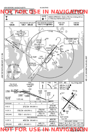
The publications depicting instrument approach procedures are called Terminal Procedures, but are commonly referred to by pilots as approach plate
Approach plate
Approach Plates is a common term used to describe the printed procedures or charts, more formally Instrument Approach Procedures, that pilots use to fly approaches during Instrument Flight Rules operations. Each country maintains their own instrument approach procedures according to International...
s. These documents graphically depict the specific procedure to be followed by a pilot for a particular type of approach to a given runway. They depict prescribed altitudes and headings to be flown, as well as obstacles, terrain, and potentially conflicting airspace. In addition, they also list missed approach procedures and commonly used radio frequencies.
In the past, the requirement for large land-based navigation aid (NAVAID) facilities has generally limited the use of instrument approaches to land-based (i.e. asphalt, gravel, turf, ice) runways (including those aboard aircraft carrier
Aircraft carrier
An aircraft carrier is a warship designed with a primary mission of deploying and recovering aircraft, acting as a seagoing airbase. Aircraft carriers thus allow a naval force to project air power worldwide without having to depend on local bases for staging aircraft operations...
s). However, recent advances in GPS approach technology have permitted the creation of instrument approaches at water aerodromes such as Rangeley Lake
Rangeley Lake
Rangeley Lake is located in Franklin County, Maine in the United States. It is fed by several streams. Its waters flow out from the lake's northwestern end into the short Rangeley River, then into Mooselookmeguntic Lake, and ultimately into the Androscoggin River, Merrymeeting Bay, the lower...
Seaplane Base in Maine
Maine
Maine is a state in the New England region of the northeastern United States, bordered by the Atlantic Ocean to the east and south, New Hampshire to the west, and the Canadian provinces of Quebec to the northwest and New Brunswick to the northeast. Maine is both the northernmost and easternmost...
, USA.
Basic principles
Instrument approaches are generally designed such that a pilot of an aircraft in instrument meteorological conditionsInstrument meteorological conditions
Instrument meteorological conditions is an aviation flight category that describes weather conditions that require pilots to fly primarily by reference to instruments, and therefore under Instrument Flight Rules , rather than by outside visual references under Visual Flight Rules . Typically, this...
(IMC), by the means of radio
Radio navigation
Radio navigation or radionavigation is the application of radio frequencies to determine a position on the Earth. Like radiolocation, it is a type of radiodetermination.The basic principles are measurements from/to electric beacons, especially...
, GPS or INS
Inertial navigation system
An inertial navigation system is a navigation aid that uses a computer, motion sensors and rotation sensors to continuously calculate via dead reckoning the position, orientation, and velocity of a moving object without the need for external references...
navigation with no assistance from air traffic control
Air traffic control
Air traffic control is a service provided by ground-based controllers who direct aircraft on the ground and in the air. The primary purpose of ATC systems worldwide is to separate aircraft to prevent collisions, to organize and expedite the flow of traffic, and to provide information and other...
, can navigate to the airport, hold in the vicinity of the airport if required, then fly to a position from where he or she can obtain sufficient visual reference of the runway for a safe landing to be made, or execute a missed approach if the visibility is below the minimums required to execute a safe landing. The whole of the approach is defined and published in this way so that aircraft can land if they suffer from radio failure; it also allows instrument approaches to be made procedurally
Procedural control
Procedural control is a method of providing air traffic control services without the use of radar. It is used in regions of the world, specifically sparsely-populated land areas and oceans, where radar coverage is either prohibitively expensive or is simply not feasible...
at airports where air traffic control does not use radar or in the case of radar failure.
An instrument approach procedure may have as many as four separate segments depending on how the approach procedure is structured. These segments include:
- Initial approach: The segment between the initial approach fixInitial approach fixThe Initial Approach Fix is the point where the initial approach segment of an instrument approach begins. An instrument approach procedure may have more than one Initial Approach Fix and initial approach segment. The initial approach fix is usually a designated intersection, VOR, NDB, or DME fix...
(IAF) and the intermediate fix (IF), or the point where the aircraft is established on the intermediate course or final approach course. - Intermediate Approach: The segment between the IF or point, and the final approach fix (FAF).
- Final approach: The segment between the FAF or point, and the runway, airport, or missed approach pointMissed approach pointMissed approach point is the "point prescribed in each instrument approach at which a missed approach procedure shall be executed if the required visual reference does not exist." It defines the point for precision and non-precision approaches when the missed approach segment of a flight begins...
(MAP). - Missed approach: The segment between the MAP or the point of arrival at decision height and the missed approach fix at the prescribed altitude.
When aircraft are under radar control
Radar control
Radar control is a method of providing air traffic control services with the use of radar and Automatic Dependent Surveillance . The provision of air traffic control services without the use of radar is called procedural control.-Separation:...
, air traffic controllers may replace some or all of these phases of the approach with radar vectors (the provision of headings on which the controller expects the pilot to navigate his aircraft) to the final approach, to allow traffic levels to be increased over those of which a fully procedural approach is capable. It is very common for air traffic controllers to vector aircraft to the final approach aid, e.g. the ILS
Instrument Landing System
An instrument landing system is a ground-based instrument approach system that provides precision guidance to an aircraft approaching and landing on a runway, using a combination of radio signals and, in many cases, high-intensity lighting arrays to enable a safe landing during instrument...
, which is then used for the final approach. In the case of the rarely used Ground-Controlled Approach
Ground-controlled approach
In aviation a ground-controlled approach , is a type of service provided by air-traffic controllers whereby they guide aircraft to a safe landing in adverse weather conditions based on radar images...
(GCA
Ground-controlled approach
In aviation a ground-controlled approach , is a type of service provided by air-traffic controllers whereby they guide aircraft to a safe landing in adverse weather conditions based on radar images...
), the instrumentation (normally Precision Approach Radar
Precision Approach Radar
Precision approach radar is a type of radar guidance system designed to provide lateral and vertical guidance to an aircraft pilot for landing, until the landing threshold is reached. After the aircraft reaches the decision height or decision altitude , guidance is advisory only...
) is on the ground and monitored by a controller, who then relays precise instructions for adjustment of heading and altitude to the pilot in the approaching aircraft.
Low visibility approaches
Many instrument approaches allow for landing in conditions of low visibility. ICAO classifies ILS approaches as being in one of the following categories:| Category | Decision Height (above threshold) | RVR Runway visual range Runway Visual Range is a term used in aviation meteorology to define the distance over which a pilot of an aircraft on the centreline of the runway can see the runway surface markings delineating the runway or identifying its centre line... limit | Visibility |
|---|---|---|---|
| I | 200 ft | 550 m or 2400 ft (1200 ft is approved at some airports) | 800 m |
| II | 100 ft | 350 m or 1200 ft | N/A |
| IIIa | 50 ft < DH < 100 ft | 200 m | N/A |
| IIIb | 0 < DH < 50 ft | less than 200 m but not less than 75 m | N/A |
| IIIc | No DH | No RVR | N/A |
CAT III minima depend on roll-out control and redundancy of the autopilot. Smaller aircraft will generally only be equipped to fly a CAT I ILS. For larger aircraft it is typical that these approaches are under the control of the flight control system with the flight crew providing a supervisory role.
A head-up display
Head-Up Display
A head-up display or heads-up display is any transparent display that presents data without requiring users to look away from their usual viewpoints...
(HUD) allows the flight crew to fly the aircraft using the guidance cues from the ILS sensors so that if such a large deviation were seen, the pilot would be able to respond in an appropriate and safe manner. This is becoming increasingly popular with "feeder" airlines and most manufacturers of regional jets are now offering HUDs as either standard or optional equipment. In addition a HUD can provide a low visibility take-off capability.
For both automatic and HUD landing systems, the equipment requires special approval for its design and also for each individual installation. The design takes into consideration all of the additional safety requirements for operating an aircraft close to the ground and takes into consideration the ability of the flight crew to react to a "system anomaly." Once installed, the equipment also has additional maintenance requirements to ensure that it is fully capable of supporting reduced visibility operations.
For all CAT II or III approaches, additional crew training is required for such approaches, and a certain number of low visibility approaches must either be performed or simulated in a set period of time for pilots to stay 'current' in performing them.
For practical reasons Category IIIc approaches are rare, but Category IIIb approaches are relatively common at major airports.
There are also air traffic control considerations with low visibility approaches: when using ILS, the integrity of the signal must be protected, which requires that certain areas of the airport close to the installations being free of other aircraft and vehicles. Also there must be bigger gaps between aircraft on final approach to both protect the ILS signal and to cope with slower runway vacation times. In addition, the airport itself has special considerations for low visibility operations including different lighting for approach area, runways, and taxiways as well as the location of emergency equipment.
Precision approaches and systems
- ILSInstrument Landing SystemAn instrument landing system is a ground-based instrument approach system that provides precision guidance to an aircraft approaching and landing on a runway, using a combination of radio signals and, in many cases, high-intensity lighting arrays to enable a safe landing during instrument...
– Instrument Landing System - MLSMicrowave landing systemA microwave landing system is an all-weather, precision landing system originally intended to replace or supplement instrument landing systems...
– Microwave Landing System - PARPrecision Approach RadarPrecision approach radar is a type of radar guidance system designed to provide lateral and vertical guidance to an aircraft pilot for landing, until the landing threshold is reached. After the aircraft reaches the decision height or decision altitude , guidance is advisory only...
– Precision Approach Radar (militaryMilitaryA military is an organization authorized by its greater society to use lethal force, usually including use of weapons, in defending its country by combating actual or perceived threats. The military may have additional functions of use to its greater society, such as advancing a political agenda e.g...
) - LAASLocal Area Augmentation SystemThe Local Area Augmentation System is an all-weather aircraft landing system based on real-time differential correction of the GPS signal. Local reference receivers located around the airport send data to a central location at the airport. This data is used to formulate a correction message, which...
– Local Area Augmentation System (a ground-based augmentation system (GBAS) for global navigation satellite systemGlobal Navigation Satellite SystemA satellite navigation or SAT NAV system is a system of satellites that provide autonomous geo-spatial positioning with global coverage. It allows small electronic receivers to determine their location to within a few metres using time signals transmitted along a line-of-sight by radio from...
s (GNSS)) - JPALSJoint Precision Approach and Landing SystemThe Joint Precision Approach and Landing System is a military, all-weather landing system based on real-time differential correction of the GPS signal, augmented with a local area correction message, and transmitted to the user via secure means...
– Joint Precision Approach and Landing System - GCA – Ground-Controlled Approach (mostly military)
- GLS – GNSS Landing System
Non-precision approaches and systems
- LocalizerLocalizerIn aviation, a localizer is one of the components of an Instrument Landing System , and it provides runway centerline guidance to aircraft. In some cases, a course projected by localizer is at an angle to the runway . It is then called a Localizer Type Directional Aid...
- VORVHF omnidirectional rangeVOR, short for VHF omnidirectional radio range, is a type of radio navigation system for aircraft. A VOR ground station broadcasts a VHF radio composite signal including the station's identifier, voice , and navigation signal. The identifier is typically a two- or three-letter string in Morse code...
– VHF Omnidirectional Range - NDBNon-directional beaconA non-directional beacon is a radio transmitter at a known location, used as an aviation or marine navigational aid. As the name implies, the signal transmitted does not include inherent directional information, in contrast to other navigational aids such as low frequency radio range, VHF...
– Non-Directional Beacon with complementary Automatic Direction Finder (ADF) installed on board - LDALocalizer Type Directional AidA Localizer Type Directional Aid is a type of localizer-based instrument approach to an airport. It is used in places where, due to terrain and other factors, the localizer antenna array is not aligned with the runway it serves. In these cases, the localizer antenna array may be offset A Localizer...
– Localizer Type Directional Aid - SDFSimplified Directional FacilitySimplified Directional Facility or SDF is a localizer-based instrument non-precision approach to an airport, which provides final approach course similar to Instrument Landing System and Localizer Type Directional Aid approaches, although not as precise.The SDF signal is fixed at either 6 or 12...
– Simplified Directional Facility - GPS – Global Positioning System (with or without vertical navigation capability, which usually requires extra precision typically afforded by using WAASWide Area Augmentation SystemThe Wide Area Augmentation System is an air navigation aid developed by the Federal Aviation Administration to augment the Global Positioning System , with the goal of improving its accuracy, integrity, and availability...
, EGNOSEuropean Geostationary Navigation Overlay ServiceThe European Geostationary Navigation Overlay Service is a satellite based augmentation system developed by the European Space Agency, the European Commission and EUROCONTROL. It supplements the GPS, GLONASS and Galileo systems by reporting on the reliability and accuracy of the signals...
, or other signal correction systems) - TACANTactical Air NavigationA tactical air navigation system, commonly referred to by the acronym TACAN, is a navigation system used by military aircraft. It provides the user with bearing and distance to a ground or ship-borne station. It is a more accurate version of the VOR/DME system that provides bearing and range...
– Tactical Air Navigation - SRASurveillance radar approachIn aviation, Approach Surveillance Radar is a type of radar instrument approach provided with active assistance from Air Traffic Control. The only airborne radio equipment required for radar approaches is a functioning radio transmitter and receiver. The radar controller vectors the aircraft to...
– Surveillance Radar Approach (known in some countries as an ASR approach) - ASRAirport Surveillance RadarAn airport surveillance radar is a radar system used at airports to detect and display the position of aircraft in the terminal area.-Digital Airport Surveillance Radar :...
– Airport Surveillance Radar (military designation for SRA)
Decision height or altitude
A decision height (DH) or decision altitude (DA) is a specified heightHeight
Height is the measurement of vertical distance, but has two meanings in common use. It can either indicate how "tall" something is, or how "high up" it is. For example "The height of the building is 50 m" or "The height of the airplane is 10,000 m"...
or altitude
Altitude
Altitude or height is defined based on the context in which it is used . As a general definition, altitude is a distance measurement, usually in the vertical or "up" direction, between a reference datum and a point or object. The reference datum also often varies according to the context...
in the precision approach at which a missed approach
Missed approach
Missed approach is an instrument flight rules procedure which is a standard component segment of an instrument approach. Generally, if the pilot flying or the pilot in command determines by the time the aircraft is at the decision height or missed approach point , that the runway or its...
must be initiated if the required visual reference, such as the runway or runway environment, to continue the approach has not been acquired. This allows the pilot sufficient time to safely re-configure the aircraft to climb and execute the missed approach procedures while avoiding terrain and obstacles.
Minimum descent altitude
The minimum descent altitude (MDA) is the lowest altitude (in feet MSL) to which descent is authorized on final approach, or during circle-to-land maneuvering in execution of a non-precision approach. Unlike a DH, a missed approach need not be initiated immediately upon reaching the altitude; that decision can be made at any time before reaching the missed approach pointMissed approach point
Missed approach point is the "point prescribed in each instrument approach at which a missed approach procedure shall be executed if the required visual reference does not exist." It defines the point for precision and non-precision approaches when the missed approach segment of a flight begins...
(MAP). A pilot flying a non-precision approach may descend to the MDA and maintain it until reaching the MAP, then initiate a missed approach if the required visual reference was not obtained. An aircraft must not descend below the MDA until visual reference is obtained, which differs slightly from a DH in that while the missed approach procedure must be initiated at or prior to the DH, because of its vertical momentum, during a precision approach an aircraft may end up descending slightly below the DH during the course of the missed approach.
If a runway has both precision and non-precision approaches defined, the MDA of the non-precision approach is almost always greater than the DH of the precision approach, due to the lack of vertical guidance of the non-precision approach: the actual difference will also depend on the accuracy of the navaid upon which the approach is based, with ADF approaches and SRAs tending to have the highest MDAs.
Reverse sensing
Reverse sensing is an instrument error only associated with the localizer. It occurs when the aircraft flies a "localizer back course" approach. The CDI in the aircraft will cease to be function as a command instrument and instead will read the opposite of what the pilot is to fly; that is, the CDI will command you to fly left when the aircraft in fact needs to fly right to intercept the approach course, and vice versa. Reverse sensing is not a factor in aircraft equipped with a Horizontal Situation Indicator (HSI).Multipathing
Multipathing is the second error associated with the ILS. In this case, unlike reverse sensing, it is associated with both the glideslope and the localiser. This occurs when distortions of the glide slope or radio waves are received by the aircraft. Distorted signals can reach the aircraft when a large metal object moves into the radiation zone of the transmitter. For instance an aircraft ahead of you or a taxiing aircraft or truck on the taxi way will produce a distorted signal..Reversal procedure
If conducting approach, and the pilot is not lined up for a Straight-in Approach, then a course reversal may be necessary. This can be used on either a VOR, ADF or ILS approach. The idea of a reversal is to turn the aircraft around by 180 degrees therefore lining the aircraft up with the runway. This will line the aircraft up for final, and can be accomplished in three different ways: Procedure Turn, Holding Pattern, or Teardrop Course Reversal.- Procedure turn: Standardized way of reversing course to get lined up on final approach. The approach chart must indicate that a procedure turn is authorized for the approach, via a procedure turn barb. Note that when a procedure turn exists for an approach, the maximum speed of the aircraft should never exceed 200 knots IAS. This is typically entered by tracking the localizer outbound, and then turning 45 degrees off of the localizer. After that, the pilot extends the leg, and conducts a roughly 180-degree turn, depending on the wind, and then flying back toward the localizer path and reintercepting it, so the pilot can track the localizer inbound.
- HoldingHolding (aviation)In aviation, holding is a maneuver designed to delay an aircraft already in flight while keeping it within a specified airspace.-Implementation:...
pattern: commonly referred to as the racetrack pattern. It is another method of course reversal, but it can also be used for losing altitude within protected airspace. Only one circuit within the holding pattern is approved. ATC must be advised if the pilot needs more circuits, and ATC must approve the request prior to doing so. A holding pattern used for this purpose will be depicted in U.S. Government publications as the "hold-in-lieu-of-PT" holding pattern symbol. - Teardrop procedure turn: If the controlled airspace is extremely limited, a teardrop may be used to reverse the direction of the aircraft and permit the aircraft to lose altitude. This procedure is shaped like a teardrop, hence the name. The approach chart, usually the profile view section, will give limitations as to how far you can get from the VOR. So, this method of course reversal is all about perception. The pilot must use timing, given a known airspeed, or DME to remain within the limits described on the approach chart.
Direct approach
A Direct instrument approach requires no procedure turn or other reversal course procedures for alignment (NoPT), as the arrival direction coincides with the final approach course. The direct approach can be finished with a straight-in landing or circle to land procedure, if necessary and published.Circling to land
A circle to land maneuver is the opposite of a straight-in landing. It is a maneuver used when a runway is not aligned within 30 degrees of the final approach course of the instrument approach procedure or the final approach requires 400 feet of descent (or more) per nautical mile, and therefore requires some visual maneuvering of the aircraft in the vicinity of the airport after the instrument portion of the approach is completed for the aircraft to become aligned with the runway to land.It's very common for a circle to land maneuver be executed during a straight-in approach to a different runway, e.g. an ILS approach to one runway, followed by a low-altitude pattern flying, ending in a landing on a different runway. This way, approach procedures to one runway can be used to land on any runway at the airport, as the other runways may lack instrument procedures or their approaches cannot be used for other reasons (traffic considerations, navigation aids being out of service, etc.).
Circling to land is considered more difficult and less safe than a straight-in landing, especially under Instrument meteorological conditions
Instrument meteorological conditions
Instrument meteorological conditions is an aviation flight category that describes weather conditions that require pilots to fly primarily by reference to instruments, and therefore under Instrument Flight Rules , rather than by outside visual references under Visual Flight Rules . Typically, this...
, due to the fact that the aircraft is at a relatively low altitude and must remain within a small distance from the airport in order to be assured of obstacle clearance (often only a couple of miles, even for larger, faster aircraft). In any case, the pilot must maintain visual contact with the runway at all times - loss of visual contact must result in an immediate climb to the published safe altitude.
Pilots should be aware that there are significant differences in obstacle clearance criteria between procedures designed in accordance with ICAO PANS-OPS and US TERPS. This is especially true in respect of Circling Approaches where the assumed radius of turn and minimum obstacle clearance are markedly different.
Instrument currency
In some countries instrument-rated pilots are required to perform a minimum number of instrument approaches in a set period to remain current. Pilots may also have to fly a certain number of low visibility approaches (CAT II or CAT III) to remain current at performing these. When practicing instrument approaches in visual meteorological conditionsVisual meteorological conditions
In aviation, visual meteorological conditions is an aviation flight category in which visual flight rules flight is permitted—that is, conditions in which pilots have sufficient visibility to fly the aircraft maintaining visual separation from terrain and other aircraft. They are the opposite of...
, a safety pilot
Safety pilot
A safety pilot is a certified pilot who scans for other aircraft while another pilot practices instrument approaches or other maneuvers under simulated low visibility conditions while the practicing pilot wears a view limiting device that prevents the pilot from seeing outside the cockpit window...
will be required if the pilot practicing instrument approach wears a view-limiting device, which restricts his field of view to the instrument panel. A safety pilot's basic role is to observe and help to avoid traffic.
In the United States, to maintain IFR currency, a pilot must have flown 6 instrument approaches and holds within the last 6 months. After this period there is a grace period of another 6 months, that allows flight with a safety pilot; after that, examination by an instructor is required.
Back Course Approach
A back course approach is a type of approach in which a pilot flies the localizer on the opposite (back) side from the original direction it was primarily designed to be flown. Usually, when one flies a front course approach, the shaded side of the localizer will be on the right on an approach plate. However, if flying a back course approach, the shaded side of the localizer would be on the left, due to the back course heading. By flying the back course, the Course Deviation IndicatorCourse deviation indicator
Course Deviation Indicator is an avionics instrument used in aircraft navigation to determine an aircraft's lateral position in relation to a track. If the location of the aircraft is to the left of course, the needle deflects to the right, and vice versa.-Use:The instrument shows the direction...
(CDI) needle will deflect to the opposite side, depending on what type of equipment exists in the aircraft. If the needle starts to move away from center, the aircraft would be flown away from the needle in order to re-intercept the correct inbound track; turning toward the needle, such as is required on a front course, would cause the aircraft to deviate further from the correct inbound track.
The localizer transmits on both sides, making this approach possible. Because the glide slope is not transmitted on the back side of the localizer, a back course approach is classed as a non-precision approach as it has no vertical guidance. Any (false) movements of the glideslope needle during a back course approach must always be ignored.
This type of approach typically is found at smaller airports that do not have ILS approaches on both ends of the runway, where often the older localizer antennas are less directional. These transmit a signal from the back that is sufficient enough to be used in a back course approach. Newer localizer antennas are highly directional, and often cannot be used for a back course approach.
Simultaneous close parallel approaches
At some airports, multiple parallel runways are available for operations, but are so closely spaced (less than 4300 feet between centerlines) that they present a hazard for simultaneous use under ordinary conditions. Simultaneous operations on such runways can be carried out using ILS and special Precision Runway MonitorPrecision Runway Monitor
In aviation, Precision Runway Monitor System is a high-speed, high-precision radar system developed by Raytheon for use in monitoring simultaneous close parallel instrument approaches to airports...
radars and three controllers, with special procedures known as simultaneous close parallel approaches.
In this type of approach, two aircraft approach and land simultaneously on closely spaced parallel runways, with extra air traffic controllers assigned to monitor each approach path on special PRM
Precision Runway Monitor
In aviation, Precision Runway Monitor System is a high-speed, high-precision radar system developed by Raytheon for use in monitoring simultaneous close parallel instrument approaches to airports...
radar. A zone between the runways is designated as the No Transgression Zone (NTZ), and if either of the aircraft nears or strays into this zone, the other approaching aircraft is told to break off by the PRM controller, at which point that aircraft must veer away from the approach path (without the use of autopilot). The aircraft must have two radios, one tuned to the tower controller in the usual way, and another tuned (for monitoring only, no transmission) to the PRM controller.
If runways are less than 3000 feet apart but at least 750 feet apart, simultaneous offset instrument approaches (SOIAs) may be used. The procedure is similar to that described above, except that one aircraft flies the ILS/PRM approach, and the other flies an offset LDA/PRM approach at an angle to the runway centerline. The aircraft flying the LDA/PRM approach with glide path is positioned to be behind the ILS/PRM aircraft, and must have the ILS/PRM aircraft in sight before beginning a visual segment to the approach at or before the missed approach point. During the visual segment, the LDA/PRM aircraft must keep the ILS/PRM aircraft in sight as it aligns with the centerline of the runway.
Visual Approach
A visual approach is a nonprecision approach carried out using visual references to the runway, when weather conditions permit. While it is not an instrument approach in the strict sense, visual approach clearances are issued only to IFR flights (because VFR flights must always approach and land visually).A visual approach may be requested by the pilot or offered by ATC. Visual approaches are possible when weather conditions permit continuous visual contact with the destination airport. They are issued in such weather conditions in order to expedite handling of IFR traffic.
A pilot may accept a visual approach clearance as soon as he has the destination airport in sight. ATC must ensure that weather conditions at the airport are above certain minima (in the U.S., a ceiling of 1000 feet AGL or greater and visibility of 3 statute miles) before issuing the clearance. Once the pilot has accepted the clearance, he assumes responsibility for separation and wake turbulence avoidance and may navigate as necessary to complete the approach visually.
Visual approaches are very commonly used for IFR flights at some airports that routinely experience good visual meteorological conditions.
Airport Requirements
In the United States, the requirements for an airport to offer instrument approaches are contained in FAA Order 8200.97 AIRMAN AND AIRCRAFT APPROVAL FOR REDUCED VISIBILITY FLIGHT OPERATIONS, INCLUDING CATEGORY II/III OPERATIONS.Audio and Multimedia Resources
- Audio and commentary of a full-procedure RNAV (GPS) approach into Flint Bishop International Airport (KFNT)
- Audio of a US instrument rating checkride - Part 1 (including RNAV 18 at KFNT)
- Audio of a US instrument rating checkride - Part 2 (including VOR 9 at KFNT partial panel and the ILS 9R at KPTK)