
Indiana State Road 145
Encyclopedia
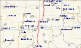
State Road 145 is a north–south road in the southwest portion of the U.S. State
of Indiana
.
about 8 miles (12.9 km) to the northeast of Tell City
, near the Perry County Municipal Airport. It runs north through the small towns of Bristow and Sassafras, and intersects Interstate 64
at exit 72 at Kitterman Corners. At Birdseye
, it meets State Road 64
and is concurrent with that road for 4.35 miles (7 km) as it heads east to the Hoosier National Forest
. It then strikes north again through the forest and across Patoka Lake
, and terminates in French Lick
at State Road 56
.
U.S. state
A U.S. state is any one of the 50 federated states of the United States of America that share sovereignty with the federal government. Because of this shared sovereignty, an American is a citizen both of the federal entity and of his or her state of domicile. Four states use the official title of...
of Indiana
Indiana
Indiana is a US state, admitted to the United States as the 19th on December 11, 1816. It is located in the Midwestern United States and Great Lakes Region. With 6,483,802 residents, the state is ranked 15th in population and 16th in population density. Indiana is ranked 38th in land area and is...
.
Route description
State Road 145 begins at State Road 37Indiana State Road 37
State Road 37 in the U.S. State of Indiana is a major route in Indiana, running as a 4-lane divided highway for 110 miles of its course....
about 8 miles (12.9 km) to the northeast of Tell City
Tell City, Indiana
Tell City is a city in Troy Township, Perry County, Indiana, along the Ohio River, Indiana's southern border. The population was 7,272 at the 2010 census. The city is the county seat of Perry County.-History:...
, near the Perry County Municipal Airport. It runs north through the small towns of Bristow and Sassafras, and intersects Interstate 64
Interstate 64
Interstate 64 is an Interstate Highway in the Midwestern and Southeastern United States. Its western terminus is at I-70, U.S. 40, and U.S. 61 in Wentzville, Missouri. Its eastern terminus is at an interchange with I-264 and I-664 at Bowers Hill in Chesapeake, Virginia. As I-64 is concurrent with...
at exit 72 at Kitterman Corners. At Birdseye
Birdseye, Indiana
Birdseye is a town in Jefferson Township, Dubois County, Indiana, United States. As of the 2010 census, the town population was 415. It was platted in 1880. Popular tradition says the town was first known as Bird, after Rev...
, it meets State Road 64
Indiana State Road 64
State Road 64 in the U.S. State of Indiana is an east–west highway that crosses most of the southern portion of the state, covering a distance of about .-Route description:...
and is concurrent with that road for 4.35 miles (7 km) as it heads east to the Hoosier National Forest
Hoosier National Forest
The Hoosier National Forest, in the hills of south central Indiana, is a property managed by the United States Forest Service. Composed of four separate sections, it has a total area of . It is headquartered in Bedford, with a regional office in Tell City...
. It then strikes north again through the forest and across Patoka Lake
Patoka Lake
Patoka Lake is the second largest reservoir in Indiana and is spread across Dubois, Crawford, and Orange counties in southern Indiana.Created as a joint effort between the US Army Corps of Engineers and the Indiana Department of Natural Resources the lake is one of eight such reservoirs built in...
, and terminates in French Lick
French Lick, Indiana
French Lick is a town in French Lick Township, Orange County, Indiana, United States. The population was 1,807 at the 2010 census. In early 2006 the French Lick Resort Casino, the state's tenth casino in the modern legalized era, opened drawing national attention to the small town.- History :French...
at State Road 56
Indiana State Road 56
State Road 56 in the U.S. state of Indiana is a route that travels the south central part of the state from west to east.-Route description:...
.