

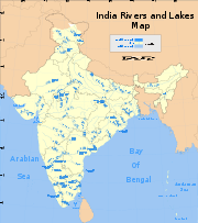
Indian Rivers Inter-link
Encyclopedia
India
India , officially the Republic of India , is a country in South Asia. It is the seventh-largest country by geographical area, the second-most populous country with over 1.2 billion people, and the most populous democracy in the world...
's rivers by canals and so reduce persistent water shortages in parts of India.
History
Plans for parts of the Indian Rivers Inter-link were mooted in the British period. In 1972 the then Minister for Irrigation K. L. Rao proposed a 2640 kilometer long link between the Ganges and Cauvery rivers. In 1974 plans were proposed for the Garland canal. In 1982 the National Water Development Agency was set up to carry out surveys of the links and prepare feasibility studies.The Project
The Inter-link would consist of two parts, a northern Himalayan River Development component and a southern Peninsular River Development component.Himalayan development
The northern component would consist of a series of dams built along the Ganges and Brahmaputra rivers in India, NepalNepal
Nepal , officially the Federal Democratic Republic of Nepal, is a landlocked sovereign state located in South Asia. It is located in the Himalayas and bordered to the north by the People's Republic of China, and to the south, east, and west by the Republic of India...
and Bhutan
Bhutan
Bhutan , officially the Kingdom of Bhutan, is a landlocked state in South Asia, located at the eastern end of the Himalayas and bordered to the south, east and west by the Republic of India and to the north by the People's Republic of China...
for the purposes of storage. Canals would be built to transfer surplus water from the eastern tributaries of the Ganges to the west. The Brahmaputra and its tributaries would be linked with the Ganges and the Ganges with the Mahanadi river
Mahanadi River
The Mahanadi in East Central India. It drains an area of around 141,600 km2 and has a total course of 858 km. The river flows through the states of Chhattisgarh and Orissa.-Source:...
. This part of the project would provide additional irrigation for about 220,000 square kilometres and generate about 30 gigawatts of electricity. In theory it would provide extra flood control in the Ganges and Brahmaputra river basins. It could also provide excess water for the controversial Farakka Barrage
Farakka Barrage
Farakka Barrage is a barrage across the Ganges River, located in the Indian state of West Bengal, roughly from the border with Bangladesh near Chapai Nawabganj District. Construction was started in 1961 and completed in 1975. Operations began on April 21, 1975. The barrage is about long...
which could be used to flush out the silt at the port of Calcutta.
Peninsular development
The main part of the project would send water from the eastern part of India to the south and west. The southern development project would consist of four main parts. First, the Mahanadi, GodavariGodavari River
The Godavari is a river that runs from western to southern India and is considered to be one of the big river basins in India. With a length of 1465 km, it is the second longest river in India , that runs within the country and also the longest river in South India...
. Krishna
Krishna River
The Krishna River , is one of the longest rivers in central-southern India, about . It is also referred to as Krishnaveni in its original nomenclature...
and Cauvery rivers would all be linked by canals. Extra water storage dams would be built along the course of these rivers. The purpose of this would be to transfer surplus water from the Mahanadi and Godavari rivers to the south of India. Second, those rivers that flow west to the north of Bombay and the south of Tapi
Tapti River
The Tapi River ancient original name Tapi River , is a river in central India. It is one of the major rivers of peninsular India with a length of around 724 km...
would be linked. Due to the irregular fluctuations in water levels in the region, as much storage capacity would be built as possible. The water would be used by the urban areas of Bombay and also to provide irrigation in the coastal areas of Maharashtra
Maharashtra
Maharashtra is a state located in India. It is the second most populous after Uttar Pradesh and third largest state by area in India...
. Third the Ken
Ken River
The Ken River is one the major rivers of the Bundelkhand region of central India, and flows through two states, Madhya Pradesh and Uttar Pradesh...
and Chambal
Chambal River
The Chambal River is a tributary of the Yamuna River in central India, and forms part of the greater Gangetic drainage system. The river flows north-northeast through Madhya Pradesh, running for a time through Rajasthan, then forming the boundary between Rajasthan and Madhya Pradesh before turning...
rivers would be linked in order to provide better water facilities for Madhya Pradesh
Madhya Pradesh
Madhya Pradesh , often called the Heart of India, is a state in central India. Its capital is Bhopal and Indore is the largest city....
and Uttar Pradesh
Uttar Pradesh
Uttar Pradesh abbreviation U.P. , is a state located in the northern part of India. With a population of over 200 million people, it is India's most populous state, as well as the world's most populous sub-national entity...
. Finally a number of west-flowing rivers along the Western Ghats
Western Ghats
The Western Ghats, Western Ghauts or the Sahyādri is a mountain range along the western side of India. It runs north to south along the western edge of the Deccan Plateau, and separates the plateau from a narrow coastal plain along the Arabian Sea. The Western Ghats block rainfall to the Deccan...
simply discharge into the Arabian Sea
Arabian Sea
The Arabian Sea is a region of the Indian Ocean bounded on the east by India, on the north by Pakistan and Iran, on the west by the Arabian Peninsula, on the south, approximately, by a line between Cape Guardafui in northeastern Somalia and Kanyakumari in India...
. As many of these as possible would be diverted for irrigation purposes. The Peninsular part of the project would provide additional irrigation to 130,000 square kilometres and generation an additional 4 gigawatts of power.
Criticism
Critics of the Inter-link scheme have alleged that the environmental impact of these projects would be extreme. They point out that little water is genuinely "surplus" or wasted merely because it runs into the sea. Diverting water from so many rivers would have a serious impact on the mangroves of the coastal regions and hence on fish stocks, that extra irrigation will cause salt levels to rise and that the project will take precious, and disputed, water from BangladeshBangladesh
Bangladesh , officially the People's Republic of Bangladesh is a sovereign state located in South Asia. It is bordered by India on all sides except for a small border with Burma to the far southeast and by the Bay of Bengal to the south...
causing India international problems. Critics also point to the enormous costs conservatively estimated at some $115bn USD which India can ill afford. It has also been suggested that the program is a vast vote-buying exercise on the part of sections of the Indian political establishment.