
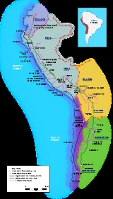
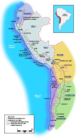
Inca road system
Encyclopedia
Inca Trail to Machu Picchu
The Inca trail to Machu Picchu consists of three overlapping trails: Mollepata, Classic and One Day. Mollepata is the longest of the three routes with the highest mountain pass and intersects with the Classic route before crossing "Dead Woman's Pass"...
. Part of the road network was built by cultures that precede the Inca Empire notably the Wari culture.
Main routes
The eastern route ran high in the puna grasslandPuna grassland
The Puna grassland ecoregion, of the montane grasslands and shrublands biome, is found in the central Andes Mountains of South America. It is considered one of the eight Natural Regions in Peru, but extends south as far as northern Argentina and Chile....
s and mountain valleys from Quito, Ecuador
Quito
San Francisco de Quito, most often called Quito , is the capital city of Ecuador in northwestern South America. It is located in north-central Ecuador in the Guayllabamba river basin, on the eastern slopes of Pichincha, an active stratovolcano in the Andes mountains...
to Mendoza, Argentina
Mendoza, Argentina
Mendoza is the capital city of Mendoza Province, in Argentina. It is located in the northern-central part of the province, in a region of foothills and high plains, on the eastern side of the Andes. As of the , Mendoza's population was 110,993...
. The western route followed the coastal plain except in coastal deserts where it hugged the foothills. More than twenty routes ran over the western mountains, while others traversed the eastern cordillera in the mountains and lowlands. Some of these roads reach heights of over 5000 metres (16,404.2 ft) above sea level. The trails connected the regions of the Inca empire
Inca Empire
The Inca Empire, or Inka Empire , was the largest empire in pre-Columbian America. The administrative, political and military center of the empire was located in Cusco in modern-day Peru. The Inca civilization arose from the highlands of Peru sometime in the early 13th century...
from the northern provincial capital in Quito, Ecuador
Quito
San Francisco de Quito, most often called Quito , is the capital city of Ecuador in northwestern South America. It is located in north-central Ecuador in the Guayllabamba river basin, on the eastern slopes of Pichincha, an active stratovolcano in the Andes mountains...
past the modern city of Santiago, Chile
Santiago, Chile
Santiago , also known as Santiago de Chile, is the capital and largest city of Chile, and the center of its largest conurbation . It is located in the country's central valley, at an elevation of above mean sea level...
in the south. The Inca road system linked together about 40000 kilometres (24,854.9 mi) of roadway and provided access to over 3000000 square kilometres (1,158,306.5 sq mi) of territory.
Situated between 500 to 800 m (1,640.4 to 2,624.7 ft) above sea level, this monumental road, which could reach 20 metres (65.6 ft) in width, connected populated areas, administrative centres, agricultural and mining zones as well as ceremonial centres and sacred spaces.
These roads provided easy, reliable and quick routes for the Empire's civilian and military communications, personnel movement, and logistical support. The prime users were imperial soldiers, porters and llama
Llama
The llama is a South American camelid, widely used as a meat and pack animal by Andean cultures since pre-Hispanic times....
caravans, along with the nobility and individuals on official duty. Permission was required before others could walk along the roads, and tolls were charged at some bridges. Although the Inca roads varied greatly in scale, construction, and appearance, for the most part they varied between about 1 to 4 m (3.3 to 13.1 ft) in width.
Much of the system was the result of the Incas claiming exclusive right over numerous traditional routes, some of which had been built centuries earlier mostly by the Wari Empire
Wari Empire
The Wari Empire was a political formation that emerged around AD 600 in the central highlands of Peru and lasted for about 500 years, to 1100 AD. It operated about the same time as the Tiwanaku culture and at one time was thought to have been derived from it. In 2008 archeologists found a...
. Many new sections were built or upgraded substantially: through Chile's Atacama desert, and along the western margin of Lake Titicaca, serve as two examples. The Incas developed techniques to overcome the difficult territory of the Andes
Andes
The Andes is the world's longest continental mountain range. It is a continual range of highlands along the western coast of South America. This range is about long, about to wide , and of an average height of about .Along its length, the Andes is split into several ranges, which are separated...
. On steep slopes they built stone steps resembling giant flights of stairs. In desert areas near the coast they built low walls to keep the sand from drifting over the road.
The Qhapaq Ñan (English: Great Inca Road, or Main Andean Road, and meaning "the beautiful road") constituted the principal north-south highway of the Inca Empire
Inca Empire
The Inca Empire, or Inka Empire , was the largest empire in pre-Columbian America. The administrative, political and military center of the empire was located in Cusco in modern-day Peru. The Inca civilization arose from the highlands of Peru sometime in the early 13th century...
traveling 6000 kilometres (3,728.2 mi) along the spine of the Andes
Andes
The Andes is the world's longest continental mountain range. It is a continual range of highlands along the western coast of South America. This range is about long, about to wide , and of an average height of about .Along its length, the Andes is split into several ranges, which are separated...
.
The Qhapaq Ñan unified this immense and heterogeneous empire through a well-organized political system of power. It allowed the Inca to control his Empire and to send troops as needed from the capital, Cusco
Cusco
Cusco , often spelled Cuzco , is a city in southeastern Peru, near the Urubamba Valley of the Andes mountain range. It is the capital of the Cusco Region as well as the Cuzco Province. In 2007, the city had a population of 358,935 which was triple the figure of 20 years ago...
.
The most important Inca road was the Camino Real, as it is known in Spanish, with a length of 5200 kilometres (3,231.1 mi). It began in Quito, Ecuador, passed through Cusco, and ended in what is now Tucumán, Argentina. The Camino Real traversed the mountain ranges of the Andes, with peak altitudes of more than 5000 m (16,404.2 ft). El Camino de la Costa, the coastal trail, with a length of 4000 kilometres (2,485.5 mi), ran parallel to the sea and was linked with the Camino Real by many smaller routes.
Bridges
Various means were used to bridge water courses. Rafts were used to cross wide meandering rivers. Bridges built of stone or floating reeds were used in marshy highlands. Inca rope bridges provided access across narrow valleys. A bridge across the Apurímac River, west of Cuzco, spanned a distance of 45 metres. Ravines were sometimes crossed by hanging baskets, or oroya, which could span distances of over 50 metres. Bridges were sometimes built in pairs.
Inca Trail to Machu Picchu
Machu PicchuMachu Picchu
Machu Picchu is a pre-Columbian 15th-century Inca site located above sea level. It is situated on a mountain ridge above the Urubamba Valley in Peru, which is northwest of Cusco and through which the Urubamba River flows. Most archaeologists believe that Machu Picchu was built as an estate for...
itself was far off the beaten path, and served as a royal estate populated by the ruling Inca and several hundred servants. It required regular infusions of goods and services from Cuzco and other parts of the empire. This is evidenced by the fact that there are no large government storage facilities at the site. A 1997 study concluded that the site's agricultural potential would not have been sufficient to support residents, even on a seasonal basis.
Schematic overview of the altitude changes
The trail starts around Km 82 along the Urubamba River in a zone that the Peruvians call "Quechua": This zone is between 2300–3500m (7,539–11,473 ft) and has temperate, dry weather with average temperatures that range from 0 to 21C (32 to 70F). The rainy season is from December to March. The rest of the year is dry or even parched from May through September. This region is extensively cultivated and essentially, there is no natural vegetation left.Effect of the conquest
The true extent of the road network is not completely known, since the Spaniards, post conquestSpanish conquest of the Inca Empire
The Spanish conquest of the Inca Empire was one of the most important campaigns in the Spanish colonization of the Americas. This historic process of military conquest was made by Spanish conquistadores and their native allies....
, either dug up the road completely in some areas, or allowed it to deteriorate and fall into ruin under iron-clad horses' hooves, or the metal wheels of ox-carts.
Today, only 25 percent of this route is still visible, the rest having been destroyed by the construction of modern infrastructure. Different organizations such as UNESCO
UNESCO
The United Nations Educational, Scientific and Cultural Organization is a specialized agency of the United Nations...
and IUCN have been working to protect this route, in collaboration with the governments and communities of the 6 countries through which the Great Inca Road passes.
Further reading
- Moseley, Michael 1992. The Incas and their Ancestors: The archaeology of Peru. Thames and Hudson, New York.
- Hyslop, John, 1984. Inka Road System. Academic Press, New York.
- Inca: Lords of Gold and Glory. Virginia: Time-Life Books, 1992.
- Andean World: Indigenous History: Culture and Consciousness by Kenneth Adrien.
- Footprints Cusco and The Inca Trail Handbook by Peter FrostPeter Frost (archaeologist)Peter Frost is a British writer, photographer, and archaeologist who spent much of his time exploring Peru and wrote several books about the country. While leading a National Geographic expedition, Frost discovered the pre-Inca site of Qoriwayrachina....
and Ben Box - Jenkins, David "A Network Analysis of Inka Roads, Administrative Centers and Storage Facilities." Ethnohistory, 48:655-685 (Fall, 2001).