
Illinois Route 72
Encyclopedia
Illinois Route 72 is an east–west state road in northeastern Illinois
. It runs from the intersection with Illinois Route 73
north of Lanark
east to Illinois Route 43
(Harlem Avenue) in Chicago
. This is a distance of 110.71 miles (178.2 km).
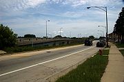 Illinois 72 is called Higgins Road for most of its length in the Chicago area, and has been redirected in parts of the area to accommodate for new features. Near Rosemont
, the road has been shifted to make way for O'Hare International Airport
— further east, parts of the road have been moved to make room for the Northwest Tollway
(Interstate 90). The road serves as a major six-lane thoroughfare for several western suburbs, including Schaumburg
, Elk Grove Village
, and Hoffman Estates
.
Illinois 72 runs concurrently
for one block with Illinois Route 83
in Elk Grove Township, and Illinois Route 47
and U.S. Highway 20 by Starks
, an unincorporated village approximately 60 miles (96.6 km) from Chicago. The latter is a Wrong-way concurrency, where one can be driving both west on Illinois 72 and east on U.S. 20 at the same time. West from Chicago, Illinois 72 largely parallels Interstate 90 until Starks, crossing over and under the highway six times without an intersection. On a larger scale, it is the main east–west artery to Chicago between Interstate 90 and Illinois Route 64
.
Route 72 is one of seven state roads to enter the city of Chicago.
to Starks
. It was extended east in 1937 and 1938 to East Dundee
, and then to Chicago
. In 1973 and 1982, Illinois 72 was shortened to its current length, first west to Illinois Route 43
, and north to Illinois Route 73
.
The site of American Airlines Flight 191
is located along the road as Higgins Road, just south of the road and north of O'Hare International Airport
.
Illinois
Illinois is the fifth-most populous state of the United States of America, and is often noted for being a microcosm of the entire country. With Chicago in the northeast, small industrial cities and great agricultural productivity in central and northern Illinois, and natural resources like coal,...
. It runs from the intersection with Illinois Route 73
Illinois Route 73
Illinois Route 73 is a north–south state highway in northwest Illinois. It runs from the U.S. Route 52/Illinois Route 64 concurrency south of Lanark north to the Wisconsin border north of Winslow. This is a distance of .- Route description :...
north of Lanark
Lanark, Illinois
Lanark is a city in Carroll County, Illinois, United States. The population was 1,457 at the 2010 census, down from 1,584 at the 2000 census.-History:...
east to Illinois Route 43
Illinois Route 43
Illinois Route 43 is a major north–south state road in the U.S. state of Illinois. It runs from U.S. Route 30 in Frankfort north to the large intersection of Illinois Route 120 and U.S...
(Harlem Avenue) in Chicago
Chicago
Chicago is the largest city in the US state of Illinois. With nearly 2.7 million residents, it is the most populous city in the Midwestern United States and the third most populous in the US, after New York City and Los Angeles...
. This is a distance of 110.71 miles (178.2 km).
Route description
Rosemont, Illinois
Rosemont is a village in Cook County, Illinois, United States located immediately northwest of Chicago. The village was incorporated in 1956, though it had been settled long before that...
, the road has been shifted to make way for O'Hare International Airport
O'Hare International Airport
Chicago O'Hare International Airport , also known as O'Hare Airport, O'Hare Field, Chicago Airport, Chicago International Airport, or simply O'Hare, is a major airport located in the northwestern-most corner of Chicago, Illinois, United States, northwest of the Chicago Loop...
— further east, parts of the road have been moved to make room for the Northwest Tollway
Northwest Tollway
The Jane Addams Memorial Tollway in Illinois is a 79-mile segment of Interstate 90 from Interstate 190 in far northwest Chicago to Illinois Route 75, one mile south of the Wisconsin state line. For 16 miles , Interstate 90 is concurrent with Interstate 39 and U.S. Route 51...
(Interstate 90). The road serves as a major six-lane thoroughfare for several western suburbs, including Schaumburg
Schaumburg, Illinois
Schaumburg is a city located in Cook County in northeastern Illinois. A common misspelling of the city name is Schaumberg, a spelling which persists on some modern maps. Schaumburg is located just under northwest of downtown Chicago and approximately northwest of O'Hare International Airport. As...
, Elk Grove Village
Elk Grove Village, Illinois
Elk Grove Village is a municipality located in northeastern Illinois adjacent to O'Hare International Airport and the City of Chicago. Elk Grove Village encompasses in land area with located in Cook County and located in DuPage County, Illinois. The population was 32,745 at the 2010 census...
, and Hoffman Estates
Hoffman Estates, Illinois
Hoffman Estates is a northwestern suburb of Chicago in Illinois. The village is located primarily in Cook County with a small section in Kane County, Illinois. As of the 2000 census, the village population was 49,495 and estimated to be 52,520 in 2003...
.
Illinois 72 runs concurrently
Concurrency (road)
A concurrency, overlap, or coincidence in a road network is an instance of one physical road bearing two or more different highway, motorway, or other route numbers...
for one block with Illinois Route 83
Illinois Route 83
Illinois Route 83 is a major north–south state road in northeast Illinois. It stretches from U.S. Highway 30 by Lynwood and Dyer, Indiana north to the Wisconsin border by Antioch at Highway 83. Incidentally, this alignment is concentric with Interstate 294...
in Elk Grove Township, and Illinois Route 47
Illinois Route 47
Illinois Route 47 is a largely rural north–south state highway that runs from the Wisconsin state border at Highway 120 near Hebron, to Illinois Route 10, just south of Interstate 72 near Seymour. This is a distance of . Even though Route 47 is primarily rural, in several suburbs of Chicago,...
and U.S. Highway 20 by Starks
Starks, Illinois
Starks, Illinois, is an unincorporated community in Kane County in the U.S. state of Illinois, located just south of the McHenry County border. Hampshire lies to its northwest, and Pingree Grove lies to its southeast....
, an unincorporated village approximately 60 miles (96.6 km) from Chicago. The latter is a Wrong-way concurrency, where one can be driving both west on Illinois 72 and east on U.S. 20 at the same time. West from Chicago, Illinois 72 largely parallels Interstate 90 until Starks, crossing over and under the highway six times without an intersection. On a larger scale, it is the main east–west artery to Chicago between Interstate 90 and Illinois Route 64
Illinois Route 64
Illinois Route 64 is an east–west road in north-central Illinois. Its western terminus is at the Iowa state line, connecting with U.S. Route 52 and Iowa Highway 64 via the Savanna-Sabula Bridge at the Mississippi River west of Savanna...
.
Route 72 is one of seven state roads to enter the city of Chicago.
History
SBI Route 72 originally ran from LanarkLanark, Illinois
Lanark is a city in Carroll County, Illinois, United States. The population was 1,457 at the 2010 census, down from 1,584 at the 2000 census.-History:...
to Starks
Starks, Illinois
Starks, Illinois, is an unincorporated community in Kane County in the U.S. state of Illinois, located just south of the McHenry County border. Hampshire lies to its northwest, and Pingree Grove lies to its southeast....
. It was extended east in 1937 and 1938 to East Dundee
East Dundee, Illinois
East Dundee is a village in Kane County with a small section in Cook County. The population was 2,955 at the 2000 census.-Geography:East Dundee is located at ....
, and then to Chicago
Chicago
Chicago is the largest city in the US state of Illinois. With nearly 2.7 million residents, it is the most populous city in the Midwestern United States and the third most populous in the US, after New York City and Los Angeles...
. In 1973 and 1982, Illinois 72 was shortened to its current length, first west to Illinois Route 43
Illinois Route 43
Illinois Route 43 is a major north–south state road in the U.S. state of Illinois. It runs from U.S. Route 30 in Frankfort north to the large intersection of Illinois Route 120 and U.S...
, and north to Illinois Route 73
Illinois Route 73
Illinois Route 73 is a north–south state highway in northwest Illinois. It runs from the U.S. Route 52/Illinois Route 64 concurrency south of Lanark north to the Wisconsin border north of Winslow. This is a distance of .- Route description :...
.
The site of American Airlines Flight 191
American Airlines Flight 191
American Airlines Flight 191 was a regularly scheduled passenger flight in the United States from O'Hare International Airport in Chicago, Illinois, to Los Angeles International Airport. On May 25, 1979, the McDonnell Douglas DC-10-10 operating the route crashed moments after takeoff from Chicago....
is located along the road as Higgins Road, just south of the road and north of O'Hare International Airport
O'Hare International Airport
Chicago O'Hare International Airport , also known as O'Hare Airport, O'Hare Field, Chicago Airport, Chicago International Airport, or simply O'Hare, is a major airport located in the northwestern-most corner of Chicago, Illinois, United States, northwest of the Chicago Loop...
.