

Illinois Route 2
Encyclopedia
Illinois Route 2 is a north–south state road in northern Illinois
. It currently starts at Illinois Route 40
in Sterling
and ends at the Wisconsin
state line north of South Beloit
, very near the intersection with U.S. Route 51
, Illinois Route 75
and Illinois Route 251
. Illinois 2 is 73.91 miles (118.95 km) long.
to South Beloit
. It was used in the 19th century as a primary trading route from Rockford
to Rock Island, The Rock River
was not used as a trading route for boats as it is only navigable west of Rock Falls
.
Illinois 2 has since been superseded by Interstate 39
and Interstate 88
for most ground transportation, but the original route remains.
on November 4, 1970. The sign can be found in a park just over the Winnebago County
border in Ogle County along the Rock River.
 .
.
Illinois
Illinois is the fifth-most populous state of the United States of America, and is often noted for being a microcosm of the entire country. With Chicago in the northeast, small industrial cities and great agricultural productivity in central and northern Illinois, and natural resources like coal,...
. It currently starts at Illinois Route 40
Illinois Route 40
Illinois Route 40 is a north–south route in central portion of the U.S. state of Illinois. It runs from Interstate 74 in East Peoria north to Illinois Route 78 at Mt. Carroll, just south of U.S. Route 52 and Illinois Route 64. This is a distance of ....
in Sterling
Sterling, Illinois
Sterling is a city in Whiteside County, Illinois, United States. The population was 15,370 at the 2010 census, down from 15,451 at the 2000 census. Formerly nicknamed "The Hardware Capital of the World", Sterling has long been associated with manufacturing and the steel...
and ends at the Wisconsin
Wisconsin
Wisconsin is a U.S. state located in the north-central United States and is part of the Midwest. It is bordered by Minnesota to the west, Iowa to the southwest, Illinois to the south, Lake Michigan to the east, Michigan to the northeast, and Lake Superior to the north. Wisconsin's capital is...
state line north of South Beloit
South Beloit, Illinois
South Beloit is a city located in Winnebago County, Illinois, United States. It is part of the Rockford, Illinois Metropolitan Statistical Area...
, very near the intersection with U.S. Route 51
U.S. Route 51
U.S. Route 51 is a north–south United States highway that runs for 1,286 miles from the western suburbs of New Orleans, Louisiana to within of the Wisconsin-Michigan border. Much of the highway in Illinois and southern Wisconsin runs parallel to or overlaps Interstate 39...
, Illinois Route 75
Illinois Route 75
Illinois Route 75 is an east–west state road in north-central Illinois. It runs from downtown Freeport at Illinois Route 26 to WIS 67 at the Wisconsin state line southeast of Beloit, Wisconsin. This is a distance of .- Route description :...
and Illinois Route 251
Illinois Route 251
Illinois Route 251 is a north–south state road that runs on the former alignment of U.S. Route 51 before Interstate 39 was built in central Illinois. It runs from U.S. 51 at the border with Wisconsin to I-39 and U.S. 51 south of Kappa. Illinois 251 is long.- Route description :Illinois 251...
. Illinois 2 is 73.91 miles (118.95 km) long.
Route description
Illinois 2 follows the Rock River from Rock IslandRock Island, Illinois
Rock Island is the county seat of Rock Island County, Illinois, United States. The population was 40,884 at the 2010 census. Located on the Mississippi River, it is one of the Quad Cities, along with neighboring Moline, East Moline, and the Iowa cities of Davenport and Bettendorf. The Quad Cities...
to South Beloit
South Beloit, Illinois
South Beloit is a city located in Winnebago County, Illinois, United States. It is part of the Rockford, Illinois Metropolitan Statistical Area...
. It was used in the 19th century as a primary trading route from Rockford
Rockford, Illinois
Rockford is a mid-sized city located on both banks of the Rock River in far northern Illinois. Often referred to as "The Forest City", Rockford is the county seat of Winnebago County, Illinois, USA. As reported in the 2010 U.S. census, the city was home to 152,871 people, the third most populated...
to Rock Island, The Rock River
Rock River (Illinois)
The Rock River is a tributary of the Mississippi River, approximately long, in the U.S. states of Wisconsin and Illinois. It rises in southeast Wisconsin, in the Theresa Marsh near Theresa, Wisconsin in northeast Dodge County, Wisconsin approximately south of Fond du Lac, Wisconsin...
was not used as a trading route for boats as it is only navigable west of Rock Falls
Rock Falls, Illinois
Rock Falls is a city in Whiteside County, Illinois, United States. The population was 9,266 at the 2010 census, down from 9,580. The city is located on the Rock River.- Geography :Rock Falls is located at ....
.
Illinois 2 has since been superseded by Interstate 39
Interstate 39
Interstate 39 is a highway in the midwestern United States. I-39 runs from Normal, Illinois at Interstate 55 to Highway 29 in Rothschild, Wisconsin, approximately six miles south of Wausau. I-39 was designed to replace US Highway 51, which in the early 1980s was one of the busiest two-lane...
and Interstate 88
Interstate 88 (west)
Interstate 88 is an intrastate Interstate Highway in the state of Illinois. It runs from an interchange with Interstate 80 near Silvis and Moline to an interchange with Interstates 290 and 294 in Hillside, near Chicago...
for most ground transportation, but the original route remains.
Blue Star Memorial Highway
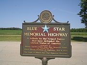
Illinois 2 was designated a Blue Star Memorial HighwayBlue Star Memorial Highway
Blue Star Memorial Highways are highways in the United States that are marked to pay tribute to the U.S. armed forces. The National Council of State Garden Clubs, now known as National Garden Clubs, Inc., started the program in 1945 after World War II. The blue star was used on service flags to...
on November 4, 1970. The sign can be found in a park just over the Winnebago County
Winnebago County, Illinois
Winnebago County is a county located in the U.S. state of Illinois. According to the 2010 census, it has a population of 295,266, which is an increase of 6.1% from 278,418 in 2000...
border in Ogle County along the Rock River.