
Ilhéu das Cabras
Encyclopedia
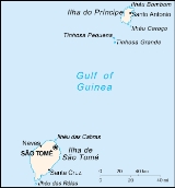
Ilhéu das Cabras is an island in the Gulf of Guinea
and is one of the smaller islands of São Tomé and Príncipe
. The islet is located just north of the coast of the island of São Tomé
north of the city of and east of the island's northernmost point and north of the Água Grande
and Lobata
district boundary.
Gulf of Guinea
The Gulf of Guinea is the northeasternmost part of the tropical Atlantic Ocean between Cape Lopez in Gabon, north and west to Cape Palmas in Liberia. The intersection of the Equator and Prime Meridian is in the gulf....
and is one of the smaller islands of São Tomé and Príncipe
São Tomé and Príncipe
São Tomé and Príncipe, officially the Democratic Republic of São Tomé and Príncipe, is a Portuguese-speaking island nation in the Gulf of Guinea, off the western equatorial coast of Central Africa. It consists of two islands: São Tomé and Príncipe, located about apart and about , respectively, off...
. The islet is located just north of the coast of the island of São Tomé
São Tomé Island
São Tomé Island, at , is the largest island of São Tomé and Príncipe and is home in 2009 to about 157,000 or 96% of the nation's population. This island and smaller nearby islets make up São Tomé Province, which is divided into six districts. The main island is located 2 km north of the...
north of the city of and east of the island's northernmost point and north of the Água Grande
Água Grande District
Água Grande is a district of São Tomé Province. Its capital, São Tomé, is also the provincial capital of São Tomé, and national capital of the equatorial Atlantic island nation of the Democratic Republic of São Tomé and Príncipe...
and Lobata
Lobata District
Lobata is a district of São Tomé Province. Out of the seven districts that make up the equatorial Atlantic islands of São Tomé and Príncipe, it is third largest in terms of population with approximately 16,500 residents and covers approximately 105 square kilometers. The district capital is...
district boundary.