

Ilemi Triangle
Encyclopedia

East Africa
East Africa or Eastern Africa is the easterly region of the African continent, variably defined by geography or geopolitics. In the UN scheme of geographic regions, 19 territories constitute Eastern Africa:...
. Arbitrarily defined, it measures between 10,320 and 14,000 square kilometers (3,985 and 5,405 sq mi). Named after Anuak chief Ilemi Akwon, the territory is claimed by South Sudan
South Sudan
South Sudan , officially the Republic of South Sudan, is a landlocked country located in the Sahel region of northeastern Africa. It is also part of the North Africa UN sub-region. Its current capital is Juba, which is also its largest city; the capital city is planned to be moved to the more...
and Kenya
Kenya
Kenya , officially known as the Republic of Kenya, is a country in East Africa that lies on the equator, with the Indian Ocean to its south-east...
and borders Ethiopia
Ethiopia
Ethiopia , officially known as the Federal Democratic Republic of Ethiopia, is a country located in the Horn of Africa. It is the second-most populous nation in Africa, with over 82 million inhabitants, and the tenth-largest by area, occupying 1,100,000 km2...
. Despite use and raids by tribes within Ethiopia, the Ethiopian government has never made an official claim on any of the Ilemi and in fact agreed that the land was all Sudanese in 1902, 1907, and 1972 treaties.
Kenya now has de facto control of the area. The dispute arose from unclear wording of a 1914 treaty which attempted to allow for the movements of the Turkana people
Turkana people
The Turkana are a Nilotic people native to the Turkana District in northwest Kenya, a dry and hot region bordering Lake Turkana in the east, Pokot, Rendille and Samburuto the south, Uganda to the west, and Sudan and Ethiopia to the north...
—nomadic herders who had traditionally grazed the area. The perceived economic marginality of the land as well as decades of Sudanese conflicts
Second Sudanese Civil War
The Second Sudanese Civil War started in 1983, although it was largely a continuation of the First Sudanese Civil War of 1955 to 1972. Although it originated in southern Sudan, the civil war spread to the Nuba mountains and Blue Nile by the end of the 1980s....
are two factors that have delayed the resolution of the dispute.
Peoples
The nomadic Turkana move in the territory between South Sudan and Kenya and have been vulnerable to attacks from surrounding peoples. The other peoples in this area are the DidingaDidinga
The Didinga occupy the Didinga Hills region in Budi County, Eastern Equatoria State in South Sudan. They live in the valleys, on the plateaus and slopes, and on the adjacent plains of the region...
and Topasa in Sudan, and the Nyangatom
Nyangatom people
The Nyangatom are a Nilotic ethnic group inhabiting southwestern Ethiopia and southeastern South Sudan...
(Inyangatom) who move between Sudan and Ethiopia, and the Dassanech who live east of the triangle in Ethiopia. These pastoral people have historically engaged in razzia raids on livestock; while in the past they used traditional weapons, since the nineteenth century onwards the use of firearms has been common.
History
Menelek II of Ethiopia
Emperor Menelik II GCB, GCMG, baptized as Sahle Maryam , was Negus of Shewa , then of Ethiopia from 1889 to his death. At the height of his internal power and external prestige, the process of territorial expansion and creation of the modern empire-state had been completed by 1898...
laid claim to Lake Turkana
Lake Turkana
Lake Turkana , formerly known as Lake Rudolf, is a lake in the Great Rift Valley in Kenya, with its far northern end crossing into Ethiopia. It is the world's largest permanent desert lake and the world's largest alkaline lake...
and proposed a boundary with the British to run from the southern end of the lake eastward to the Indian Ocean
Indian Ocean
The Indian Ocean is the third largest of the world's oceanic divisions, covering approximately 20% of the water on the Earth's surface. It is bounded on the north by the Indian Subcontinent and Arabian Peninsula ; on the west by eastern Africa; on the east by Indochina, the Sunda Islands, and...
, which was shifted northward when the British and Ethiopian governments signed a treaty in 1907, reaffirmed by a 1970 Ethiopia-Kenya treaty.
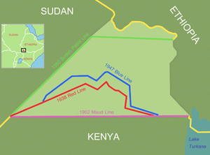
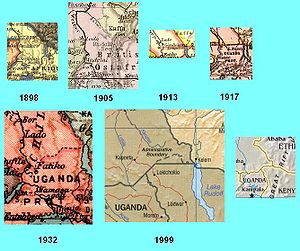
The Ethiopia-Sudan boundary, the "Maud Line", was surveyed by Captain Philip Maud
Philip Maud
Brigadier General Philip Maud was an English officer of the British Army, who is most notable for setting the Maud Line, an imaginary border in Kenya, which set the original position of the disputed Ilemi Triangle...
of the Royal Engineers
Royal Engineers
The Corps of Royal Engineers, usually just called the Royal Engineers , and commonly known as the Sappers, is one of the corps of the British Army....
in 1902-3. It was adopted by Anglo-Ethiopian Agreement treaty of December 6, 1907 between Ethiopia and British East Africa. Though vague on the precise details of where the border was located, it clearly placed the entire Ilemi on the Sudan side of the Ethiopia-Sudan line. In 1914 the Uganda-Sudan Boundary Commission agreement provided Sudan access to Lake Turkana via the now-dry Sanderson Gulf at the southeast corner of the Ilemi. After the First World War the Ethiopians armed the Nyangatom and Dassanech peoples, whereby the traditional raids turned into battles where hundreds died.
Representatives of Sudan, Uganda and Kenya in April 1924 in Kitgum
Kitgum
Kitgum is a municipality in Kitgum District, in Northern Uganda. The town is administered by Kitgum Town Council, an Urban Local Government within Kitgum District Administration...
agreed that Sudan should hand over some territory north of the 1914 line to either Kenya or Uganda, who could give protection to the Turkana people. However, Britain was jointly administering Sudan with Egypt, and did not want to pressure Egypt to concede Sudanese territory since relations were poor after Sir Lee Stack
Lee Stack
Sir Lee Oliver Fitzmaurice Stack was a British army officer and Governor-General of the Anglo-Egyptian Sudan. On 19 November 1924, he was shot and assassinated while driving through Cairo....
, the British Governor-General
Governor-General
A Governor-General, is a vice-regal person of a monarch in an independent realm or a major colonial circonscription. Depending on the political arrangement of the territory, a Governor General can be a governor of high rank, or a principal governor ranking above "ordinary" governors.- Current uses...
of Sudan, was assassinated in Cairo in November 1924. Sudan in 1928 agreed to allow Kenyan military units across the 1914 line to protect the Turkana against the Dassanech and Nyangatom, although it cost £30,000 per year. In 1929 Kenya began subsidising Sudan to occupy the territory, which it did not wish to continue because of the perceived useless nature of it. In 1931 it was Sudan which agreed to subsidise Kenya to occupy the territory.
This line was based on the grazing limits of the Turkana peoples as required in the 1914 agreement to replace the provisional straight line.
After Italy
Italy
Italy , officially the Italian Republic languages]] under the European Charter for Regional or Minority Languages. In each of these, Italy's official name is as follows:;;;;;;;;), is a unitary parliamentary republic in South-Central Europe. To the north it borders France, Switzerland, Austria and...
invaded Ethiopia in 1936, Italy briefly claimed the area of the Ilemi triangle. A joint Kenya-Sudan survey team in 1938 demarcated
Demarcation
Demarcation is the act of creating a boundary around a place or thing.Demarcation may also refer to:*Demarcation line, a temporary border between the countries...
the "Red Line" or "Wakefield Line", very close to the delimitation a few years earlier of this Red Line, marking the northern limit of grazing of Turkana. This line, to replace the provisional straight line of 1914 as required by that treaty, was carefully mapped and demarked with stone monuments. While Egypt and Britain agreed on this, Italy did not. The Dassanetch and Inyangatom had suffered because of the Italian occupation, and wished to recoup their losses by making a raid against the Turkana. Several hundred Turkana people were killed in a raid in July 1939 by the Inyangatom and Dassanech peoples. Italy gave up their claim on the Ilemi subsequently, and allowed the British to respond with a raid on the Inyangatom and Dassanech supported by the Royal Air Force
Royal Air Force
The Royal Air Force is the aerial warfare service branch of the British Armed Forces. Formed on 1 April 1918, it is the oldest independent air force in the world...
.
British troops of the King's African Rifles
King's African Rifles
The King's African Rifles was a multi-battalion British colonial regiment raised from the various British possessions in East Africa from 1902 until independence in the 1960s. It performed both military and internal security functions within the East African colonies as well as external service as...
occupied Ilemi in 1941 after the British invasion of Ethiopia
East African Campaign (World War II)
The East African Campaign was a series of battles fought in East Africa during World War II by the British Empire, the British Commonwealth of Nations and several allies against the forces of Italy from June 1940 to November 1941....
during World War II
World War II
World War II, or the Second World War , was a global conflict lasting from 1939 to 1945, involving most of the world's nations—including all of the great powers—eventually forming two opposing military alliances: the Allies and the Axis...
. The KAR passed through Ilemi on their way to southwestern Ethiopia. In 1944 Britain's Foreign Office surveyed a "blue line" which was further northwest than the "red line". Sudan, in 1950, established their own patrol line even further northwest into Sudan where they prohibited Kenyan and Ethiopian pastoralists from moving west of it, giving up policing and development to the area east of it. However, that Kenya-Sudan agreement specified that this patrol line in no way affected sovereignty; that it was not an international boundary, and money continued to be paid to Kenya to patrol this Sudanese territory. There was fighting between 1949 and 1953 as Sudan attempted to keep the Nyangatom behind this line. After Sudanese independence in 1956, Sudan has not administered Ilemi or much of the southern part of the country due to the Civil war
Sudanese Civil War
The term Sudanese Civil War refers to at least two separate conflicts:*First Sudanese Civil War - 1955–1972*Second Sudanese Civil War - 1983–2005...
there.
In 1967 President Kenyatta's administration had made overtures to the British in order to secure support for the cession of the Triangle to Kenya. The British were unresponsive and the results amounted to little. The matter was sidelined and successive Kenyan administrations have been seemingly willing to accept the territorial status quo and their de facto territorial control, even if the Kenyan influence did diminish after the relocation of the SPLM
Sudan People's Liberation Army
The Sudan People's Liberation Movement is a political party in South Sudan. It was initially founded as a rebel political movement with a military wing known as the Sudan People's Liberation Army estimated at 180,000 soldiers. The SPLM fought in the Second Sudanese Civil War against the Sudanese...
to Sudan in the 1980s-90s.
In the 1990s Ethiopia armed the Dassanech with Kalashnikov
AK-47
The AK-47 is a selective-fire, gas-operated 7.62×39mm assault rifle, first developed in the Soviet Union by Mikhail Kalashnikov. It is officially known as Avtomat Kalashnikova . It is also known as a Kalashnikov, an "AK", or in Russian slang, Kalash.Design work on the AK-47 began in the last year...
automatic rifles, perhaps in response to Kenyan government arming in 1978 of the Turkana. Beginning in the 1960's, many Kenyan maps have marked the Red Line as the official boundary of Kenya, rather than a dotted boundary which it had been previously. More recently, most Kenyan maps depict the 1950 patrol line, the furthest northwest, as the boundary. There was a question as to whether there a secret agreement was broached between Kenya and South Sudan to allow Kenya to administer this territory, in return for support in the Sudanese Civil War
Sudanese Civil War
The term Sudanese Civil War refers to at least two separate conflicts:*First Sudanese Civil War - 1955–1972*Second Sudanese Civil War - 1983–2005...
. In recent decades, the countries involved have had other priorities, delaying a resolution to the issue.
With the independence of South Sudan
South Sudan
South Sudan , officially the Republic of South Sudan, is a landlocked country located in the Sahel region of northeastern Africa. It is also part of the North Africa UN sub-region. Its current capital is Juba, which is also its largest city; the capital city is planned to be moved to the more...
in 2011, the Sudanese claim to the Ilemi Triangle transferred to the new national government in Juba.