
.gif)
Hurricane Gabrielle (2001)
Encyclopedia
Hurricane Gabrielle was a moderate category 1 hurricane which made landfall near Venice, Florida
as a strong tropical storm. The eighth tropical cyclone, seventh named storm, and third hurricane of the 2001 Atlantic hurricane season
, Gabrielle developed from a non-tropical low-to mid-level trough on September 11, 2001 in the southeastern Gulf of Mexico
. Weak steering currents caused Gabrielle to meander of offshore Florida
, while strengthening slowly. Strengthened into a tropical storm, Gabrielle made landfall in southwestern Florida. Crossing Florida, Gabrielle emerged into the Atlantic, where it further strengthened into a hurricane. Hurricane Gabrielle weakened back to a tropical storm shortly thereafter, and became fully extratropical on September 19, 2001.
Throughout its duration, the storm caused heavy rainfall and surf in Alabama
, Bermuda
, Canada
, and Florida. Gabrielle caused 3 deaths, one of those indirect; it is estimated that Gabrielle caused $230 million (2001 USD).
was nearly stationary a short distance off the southeastern coastline of the United States
. It remained stationary for several days, and on September 11 a low-level circulation developed about 125 miles (201.2 km) south-southeast of Charleston
. With minimal associated convection, the system degenerated into an open trough as it drifted southwestward due to weak steering currents. The broad feature extending from the Bahamas to the eastern Gulf of Mexico
gradually developed a mid-level center by September 9 over Florida
. A surface low pressure area
developed on September 10 over the eastern Gulf of Mexico,
and despite disorganized convection conditions
favored further development. The low gradually became better organized, and by the time of the September 11, 2001 attacks
, the low was well-organized enough with sufficiently organized convection for the National Hurricane Center
to classify it as Tropical Depression Eight while located about 170 miles (270 km) west-northwest of Key West, Florida
.
Located in an environment of weak steering currents, the depression drifted to the west-southwest. Northerly wind shear
and the presence of an upper-level low near the system initially prevented further organization, leaving the center of the depression poorly defined with minimal convection. The depression gradually became better organized as it slowly executed a small counter-clockwise loop, and early on September 12 the system developed increased banding features over the eastern half of its circulation. By early on September 13 the upper level outflow over the depression became much more conducive for intensification, though at the surface the circulation initially remained very broad with light winds around the center. Shortly thereafter, deep convection developed and persisted near the center, and at 1200 UTC on September 13 the depression intensified into Tropical Storm Gabrielle while located about 200 miles (321.9 km) southwest of Venice, Florida
. Under the influence of a mid-level trough
, the storm accelerated northeastward and quickly intensified despite increasing amounts of westerly wind shear. Its center reformed several times under the deep convection, and on September 14 Gabrielle made landfall
near Venice, Florida
with winds of 70 mi/h. At the time, Hurricane Hunters
reported gusts to hurricane force, and the National Hurricane Center indicated the possibility that Gabrielle made landfall as a hurricane.
.jpg) Land interaction and vertical wind shear quickly weakened Gabrielle over land; its convection decreased markedly with the strongest remaining convection remaining well to the northeast of the center. Upon reaching the Atlantic Ocean
Land interaction and vertical wind shear quickly weakened Gabrielle over land; its convection decreased markedly with the strongest remaining convection remaining well to the northeast of the center. Upon reaching the Atlantic Ocean
18 hours after it made landfall with winds of 45 mi/h, one forecaster at the National Hurricane Center
remarked that the storm resembled an occluded frontal low
, with a large circulation devoid of convection in a non-symmetric wind field. Another forecaster likened the storm to a subtropical cyclone
due to dry air continuing to limit organization. On September 15, convection gradually developed closer to the center, though operationally forecasters were unsure whether the convection was in association with Gabrielle or to a cold front to its west. A Hurricane Hunters flight into the system reported the center of Gabrielle became elongated, resembling a trough
, with one forecaster considering the storm on the verge of becoming an extratropical cyclone
. Shortly thereafter, convection increased near the center as the storm became stronger and better organized.
Despite strong amounts of wind shear, Gabrielle intensified to attain hurricane status early on September 17 while located about 350 miles (560 km) to the west of Bermuda
. Continuing northeastward, the hurricane strengthened slightly further to reach peak winds of 80 mi/h about 230 miles (370.1 km) northwest of Bermuda. Shortly thereafter, a banding eye
briefly developed in the center of the convection. However, increased wind shear diminished the convection, and Gabrielle weakened to tropical storm status September 18. By early on September 19, wind shear dissipated nearly all of the associated deep convection, and Gabrielle transitioned into an extratropical cyclone
about 350 miles (563.3 km) south of Newfoundland. The extratropical remnant continued to the northeast, passing a short distance southeast of Newfoundland before restrengthening to reach winds of 75 mi/h. The storm weakened, and on September 21 the extratropical remnant of Gabrielle merged with another extratropical storm over the far northern Atlantic Ocean
.
issued a tropical storm warning
from Craig Key
through the Dry Tortugas
in the Florida Keys
and along the Florida
west coast from Flamingo
to the mouth of the Suwanee River. Additionally, a hurricane watch was issued from Chokoloskee
to Tarpon Springs
. The next day, a tropical storm warning was issued for Lake Okeechobee
and the Florida east coast from Jupiter
to Saint Augustine.
The government of Bermuda
issued a gale warning for the island before changing it to a tropical storm warning
on September 16.
The Newfoundland Weather Center issued severe weather warnings for portions of Atlantic Canada
prior to the arrival of the extratropical remnant of Gabrielle. Rough sea warnings were issued for waters off of the Avalon Peninsula
of eastern Newfoundland, and fishermen were recommended to remain away from the ocean.
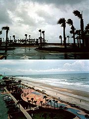 Upon making landfall, Gabrielle produced moderate winds along coastal areas of western Florida
, reaching 58 mi/h at Venice
. High tides from rough waves and the storm surge
reached 6.2 feet (1.9 m), the highest tide since 1926. The tide flooded the northern shoreline of Charlotte Harbor
and at the entrance to the Peace River
, while further to the south a surge of greater than 3 foot (0.9144 m) inundated the barrier island
at Fort Myers Beach
and flooded some cars. Beach erosion was common in the areas where the storm surge was greatest, as well.
While crossing the state, the storm produced locally strong winds along the Atlantic Florida coastline, peaking at 59 mi/h at Saint Augustine.
Gabrielle, at the time a tropical storm, produced a torrential amount of rain over the state of Florida. Amounts added up to between the 4-7 inch range along its track. A foot of rain fell in Volusia and Lake counties in northeast Florida. Other reports of urban flooding and river flooding was also acknowledged throughout the state. In addition to the severe flooding of up to one foot, many reports of tornadoes also poured in. In all, there were eighteen reports of twisters as Gabrielle came ashore.
 The hurricane coincidentally happened on the same day that the September 11, 2001 attacks
happened in New York City and Washington DC, forcing the FAA to ground public and private air traffic on the very day that this storm formed. As the storm approached an exemption was issued for Florida
, Georgia
, South Carolina
, and Alabama
. Owners were able to evacuate their aircraft and provide emergency relief flights after the storm passed. http://www.aopa.org/page_2.html#n4ga
In all, Gabrielle killed two people directly and one indirectly. A fifteen-year-old boy died of drowning in Winter Springs, Florida
. Another died due to a rip current off the coastline of Alabama
. The indirect death was the cause of an individual falling off a boat and drowning due to intoxication.
, the combination of Gabrielle and the cold front to its west dropped about 1.8 inches of precipitation in a 4 day period. Wind gusts peaked at 55 mi/h in an outer rainband. No damage was reported in the territory.
The extratropical remnant of Gabrielle passed a short distance south of Newfoundland, the second cyclone in less than a week to affect the area. The storm produced moderately strong wind gusts of over 60 mph (100 km) across the southern portion of the island, including a peak gust of 80 mph (130 km/h) at Cape Race
. The storm also produced rough seas of up to 36 feet (11 m) in height. The remnant of Gabrielle dropped heavy rainfall in a short amount of time across Newfoundland, with one station at Cape Race recording 1.9 inches (48.3 mm) in just 1 hour. The rainfall set the all time 6 hour precipitation record at St. John's
, with a total of 3.54 inches (89.9 mm). Rainfall peaked at 6.9 inches (175 mm) at the Memorial University of Newfoundland
in St. John's.
In St. John's, the rainfall caused severe flooding, with the mayor of the city considering Gabrielle "the worst storm in 100 years". There, the flooding washed out roads and parking lots, and also flooded some basements with several feet (1 m) of water. There were multiple reports of sewers unable to accompany the excess of water. Hurricane force wind gusts canceled flights and left thousands without power, telephone, or heat. Hundreds of homes and buildings were damaged by the passage of Gabrielle, totaling several million dollars in damage.
, the city mayor activated the city's Emergency Preparedness Program. On September 27, about a week after the passage of the storm, the Emergency Measures Organization began accepting applications for flood-related damage. By about a month after the storm, 169 applications were processed, with an additional 1,762 received by the Emergency Measures Organization. Eligibility for the disaster assistance included restoration to property or household items of an essential nature. A few days after the passage of the storm, the government of Newfoundland appealed to the federal government for federal disaster relief fund; the government later approved. Ultimately, disaster relief assistance totaled $6.3 million (2001 CAD), primarily to individual assistance.
Venice, Florida
Venice is a city in Sarasota County, Florida, United States. According to the U.S. Census Bureau's 2007 estimates, the city had a population of 21,015. It is noted for its large snowbird population. Its newspaper is the Venice Gondolier Sun...
as a strong tropical storm. The eighth tropical cyclone, seventh named storm, and third hurricane of the 2001 Atlantic hurricane season
2001 Atlantic hurricane season
The 2001 Atlantic hurricane season was a fairly active Atlantic hurricane season that produced 17 tropical cyclones, 15 named storms, nine hurricanes, and four major hurricanes. The season officially lasted from June 1, 2001, to November 30, 2001, dates which by convention limit the period of each...
, Gabrielle developed from a non-tropical low-to mid-level trough on September 11, 2001 in the southeastern Gulf of Mexico
Gulf of Mexico
The Gulf of Mexico is a partially landlocked ocean basin largely surrounded by the North American continent and the island of Cuba. It is bounded on the northeast, north and northwest by the Gulf Coast of the United States, on the southwest and south by Mexico, and on the southeast by Cuba. In...
. Weak steering currents caused Gabrielle to meander of offshore Florida
Florida
Florida is a state in the southeastern United States, located on the nation's Atlantic and Gulf coasts. It is bordered to the west by the Gulf of Mexico, to the north by Alabama and Georgia and to the east by the Atlantic Ocean. With a population of 18,801,310 as measured by the 2010 census, it...
, while strengthening slowly. Strengthened into a tropical storm, Gabrielle made landfall in southwestern Florida. Crossing Florida, Gabrielle emerged into the Atlantic, where it further strengthened into a hurricane. Hurricane Gabrielle weakened back to a tropical storm shortly thereafter, and became fully extratropical on September 19, 2001.
Throughout its duration, the storm caused heavy rainfall and surf in Alabama
Alabama
Alabama is a state located in the southeastern region of the United States. It is bordered by Tennessee to the north, Georgia to the east, Florida and the Gulf of Mexico to the south, and Mississippi to the west. Alabama ranks 30th in total land area and ranks second in the size of its inland...
, Bermuda
Bermuda
Bermuda is a British overseas territory in the North Atlantic Ocean. Located off the east coast of the United States, its nearest landmass is Cape Hatteras, North Carolina, about to the west-northwest. It is about south of Halifax, Nova Scotia, Canada, and northeast of Miami, Florida...
, Canada
Canada
Canada is a North American country consisting of ten provinces and three territories. Located in the northern part of the continent, it extends from the Atlantic Ocean in the east to the Pacific Ocean in the west, and northward into the Arctic Ocean...
, and Florida. Gabrielle caused 3 deaths, one of those indirect; it is estimated that Gabrielle caused $230 million (2001 USD).
Meteorological history
By September 5, a weak low- to mid-level troughTrough (meteorology)
A trough is an elongated region of relatively low atmospheric pressure, often associated with fronts.Unlike fronts, there is not a universal symbol for a trough on a weather chart. The weather charts in some countries or regions mark troughs by a line. In the United States, a trough may be marked...
was nearly stationary a short distance off the southeastern coastline of the United States
United States
The United States of America is a federal constitutional republic comprising fifty states and a federal district...
. It remained stationary for several days, and on September 11 a low-level circulation developed about 125 miles (201.2 km) south-southeast of Charleston
Charleston, South Carolina
Charleston is the second largest city in the U.S. state of South Carolina. It was made the county seat of Charleston County in 1901 when Charleston County was founded. The city's original name was Charles Towne in 1670, and it moved to its present location from a location on the west bank of the...
. With minimal associated convection, the system degenerated into an open trough as it drifted southwestward due to weak steering currents. The broad feature extending from the Bahamas to the eastern Gulf of Mexico
Gulf of Mexico
The Gulf of Mexico is a partially landlocked ocean basin largely surrounded by the North American continent and the island of Cuba. It is bounded on the northeast, north and northwest by the Gulf Coast of the United States, on the southwest and south by Mexico, and on the southeast by Cuba. In...
gradually developed a mid-level center by September 9 over Florida
Florida
Florida is a state in the southeastern United States, located on the nation's Atlantic and Gulf coasts. It is bordered to the west by the Gulf of Mexico, to the north by Alabama and Georgia and to the east by the Atlantic Ocean. With a population of 18,801,310 as measured by the 2010 census, it...
. A surface low pressure area
Low pressure area
A low-pressure area, or "low", is a region where the atmospheric pressure at sea level is below that of surrounding locations. Low-pressure systems form under areas of wind divergence which occur in upper levels of the troposphere. The formation process of a low-pressure area is known as...
developed on September 10 over the eastern Gulf of Mexico,
and despite disorganized convection conditions
Tropical cyclogenesis
Tropical cyclogenesis is the term that describes the development and strengthening of a tropical cyclone in the atmosphere. The mechanisms through which tropical cyclogenesis occurs are distinctly different from those through which mid-latitude cyclogenesis occurs...
favored further development. The low gradually became better organized, and by the time of the September 11, 2001 attacks
September 11, 2001 attacks
The September 11 attacks The September 11 attacks The September 11 attacks (also referred to as September 11, September 11th or 9/119/11 is pronounced "nine eleven". The slash is not part of the pronunciation...
, the low was well-organized enough with sufficiently organized convection for the National Hurricane Center
National Hurricane Center
The National Hurricane Center , located at Florida International University in Miami, Florida, is the division of the National Weather Service responsible for tracking and predicting weather systems within the tropics between the Prime Meridian and the 140th meridian west poleward to the 30th...
to classify it as Tropical Depression Eight while located about 170 miles (270 km) west-northwest of Key West, Florida
Key West, Florida
Key West is a city in Monroe County, Florida, United States. The city encompasses the island of Key West, the part of Stock Island north of U.S. 1 , Sigsbee Park , Fleming Key , and Sunset Key...
.
Located in an environment of weak steering currents, the depression drifted to the west-southwest. Northerly wind shear
Wind shear
Wind shear, sometimes referred to as windshear or wind gradient, is a difference in wind speed and direction over a relatively short distance in the atmosphere...
and the presence of an upper-level low near the system initially prevented further organization, leaving the center of the depression poorly defined with minimal convection. The depression gradually became better organized as it slowly executed a small counter-clockwise loop, and early on September 12 the system developed increased banding features over the eastern half of its circulation. By early on September 13 the upper level outflow over the depression became much more conducive for intensification, though at the surface the circulation initially remained very broad with light winds around the center. Shortly thereafter, deep convection developed and persisted near the center, and at 1200 UTC on September 13 the depression intensified into Tropical Storm Gabrielle while located about 200 miles (321.9 km) southwest of Venice, Florida
Venice, Florida
Venice is a city in Sarasota County, Florida, United States. According to the U.S. Census Bureau's 2007 estimates, the city had a population of 21,015. It is noted for its large snowbird population. Its newspaper is the Venice Gondolier Sun...
. Under the influence of a mid-level trough
Trough (meteorology)
A trough is an elongated region of relatively low atmospheric pressure, often associated with fronts.Unlike fronts, there is not a universal symbol for a trough on a weather chart. The weather charts in some countries or regions mark troughs by a line. In the United States, a trough may be marked...
, the storm accelerated northeastward and quickly intensified despite increasing amounts of westerly wind shear. Its center reformed several times under the deep convection, and on September 14 Gabrielle made landfall
Landfall (meteorology)
Landfall is the event of a tropical cyclone or a waterspout coming onto land after being over water. When a waterspout makes landfall it is reclassified as a tornado, which can then cause damage inland...
near Venice, Florida
Venice, Florida
Venice is a city in Sarasota County, Florida, United States. According to the U.S. Census Bureau's 2007 estimates, the city had a population of 21,015. It is noted for its large snowbird population. Its newspaper is the Venice Gondolier Sun...
with winds of 70 mi/h. At the time, Hurricane Hunters
Hurricane Hunters
The Hurricane Hunters are aircraft that fly into tropical cyclones in the North Atlantic Ocean and Northeastern Pacific Ocean for the specific purpose of directly measuring weather data in and around those storms. In the United States, the Air Force, Navy, and NOAA units have all participated in...
reported gusts to hurricane force, and the National Hurricane Center indicated the possibility that Gabrielle made landfall as a hurricane.
Atlantic Ocean
The Atlantic Ocean is the second-largest of the world's oceanic divisions. With a total area of about , it covers approximately 20% of the Earth's surface and about 26% of its water surface area...
18 hours after it made landfall with winds of 45 mi/h, one forecaster at the National Hurricane Center
National Hurricane Center
The National Hurricane Center , located at Florida International University in Miami, Florida, is the division of the National Weather Service responsible for tracking and predicting weather systems within the tropics between the Prime Meridian and the 140th meridian west poleward to the 30th...
remarked that the storm resembled an occluded frontal low
Surface weather analysis
Surface weather analysis is a special type of weather map that provides a view of weather elements over a geographical area at a specified time based on information from ground-based weather stations...
, with a large circulation devoid of convection in a non-symmetric wind field. Another forecaster likened the storm to a subtropical cyclone
Subtropical cyclone
A subtropical cyclone is a weather system that has some characteristics of a tropical and an extratropical cyclone. As early as the 1950s, meteorologists were unclear whether they should be characterized as tropical or extratropical cyclones. They were officially recognized by the National...
due to dry air continuing to limit organization. On September 15, convection gradually developed closer to the center, though operationally forecasters were unsure whether the convection was in association with Gabrielle or to a cold front to its west. A Hurricane Hunters flight into the system reported the center of Gabrielle became elongated, resembling a trough
Trough (meteorology)
A trough is an elongated region of relatively low atmospheric pressure, often associated with fronts.Unlike fronts, there is not a universal symbol for a trough on a weather chart. The weather charts in some countries or regions mark troughs by a line. In the United States, a trough may be marked...
, with one forecaster considering the storm on the verge of becoming an extratropical cyclone
Extratropical cyclone
Extratropical cyclones, sometimes called mid-latitude cyclones or wave cyclones, are a group of cyclones defined as synoptic scale low pressure weather systems that occur in the middle latitudes of the Earth having neither tropical nor polar characteristics, and are connected with fronts and...
. Shortly thereafter, convection increased near the center as the storm became stronger and better organized.
Despite strong amounts of wind shear, Gabrielle intensified to attain hurricane status early on September 17 while located about 350 miles (560 km) to the west of Bermuda
Bermuda
Bermuda is a British overseas territory in the North Atlantic Ocean. Located off the east coast of the United States, its nearest landmass is Cape Hatteras, North Carolina, about to the west-northwest. It is about south of Halifax, Nova Scotia, Canada, and northeast of Miami, Florida...
. Continuing northeastward, the hurricane strengthened slightly further to reach peak winds of 80 mi/h about 230 miles (370.1 km) northwest of Bermuda. Shortly thereafter, a banding eye
Eye (cyclone)
The eye is a region of mostly calm weather found at the center of strong tropical cyclones. The eye of a storm is a roughly circular area and typically 30–65 km in diameter. It is surrounded by the eyewall, a ring of towering thunderstorms where the second most severe weather of a cyclone...
briefly developed in the center of the convection. However, increased wind shear diminished the convection, and Gabrielle weakened to tropical storm status September 18. By early on September 19, wind shear dissipated nearly all of the associated deep convection, and Gabrielle transitioned into an extratropical cyclone
Extratropical cyclone
Extratropical cyclones, sometimes called mid-latitude cyclones or wave cyclones, are a group of cyclones defined as synoptic scale low pressure weather systems that occur in the middle latitudes of the Earth having neither tropical nor polar characteristics, and are connected with fronts and...
about 350 miles (563.3 km) south of Newfoundland. The extratropical remnant continued to the northeast, passing a short distance southeast of Newfoundland before restrengthening to reach winds of 75 mi/h. The storm weakened, and on September 21 the extratropical remnant of Gabrielle merged with another extratropical storm over the far northern Atlantic Ocean
Atlantic Ocean
The Atlantic Ocean is the second-largest of the world's oceanic divisions. With a total area of about , it covers approximately 20% of the Earth's surface and about 26% of its water surface area...
.
Preparations
Shortly after Gabrielle become a tropical storm, the National Hurricane CenterNational Hurricane Center
The National Hurricane Center , located at Florida International University in Miami, Florida, is the division of the National Weather Service responsible for tracking and predicting weather systems within the tropics between the Prime Meridian and the 140th meridian west poleward to the 30th...
issued a tropical storm warning
Tropical cyclone warnings and watches
Warnings and watches are two levels of alert issued by national weather forecasting bodies to coastal areas threatened by the imminent approach of a tropical cyclone of tropical storm or hurricane intensity. They are notices to the local population and civil authorities to make appropriate...
from Craig Key
Craig Key
Craig Key is an island in the middle Florida Keys.U.S. 1 crosses the key at approximately mile marker 72, between Lower Matecumbe Key and Fiesta Key.-History:...
through the Dry Tortugas
Dry Tortugas
The Dry Tortugas are a small group of islands, located at the end of the Florida Keys, USA, about west of Key West, and west of the Marquesas Keys, the closest islands. Still further west is the Tortugas Bank, which is completely submerged. The first Europeans to discover the islands were the...
in the Florida Keys
Florida Keys
The Florida Keys are a coral archipelago in southeast United States. They begin at the southeastern tip of the Florida peninsula, about south of Miami, and extend in a gentle arc south-southwest and then westward to Key West, the westernmost of the inhabited islands, and on to the uninhabited Dry...
and along the Florida
Florida
Florida is a state in the southeastern United States, located on the nation's Atlantic and Gulf coasts. It is bordered to the west by the Gulf of Mexico, to the north by Alabama and Georgia and to the east by the Atlantic Ocean. With a population of 18,801,310 as measured by the 2010 census, it...
west coast from Flamingo
Flamingo, Florida
Flamingo is an unincorporated community and ghost town in Monroe County, Florida, United States. It began as a small coastal settlement on the eastern end of Cape Sable on the southern tip of the Florida peninsula, facing Florida Bay...
to the mouth of the Suwanee River. Additionally, a hurricane watch was issued from Chokoloskee
Chokoloskee, Florida
Chokoloskee is a census-designated place in Collier County, Florida, United States. The population was 404 at the 2000 census. It is part of the Naples–Marco Island Metropolitan Statistical Area.-Geography:...
to Tarpon Springs
Tarpon Springs, Florida
Tarpon Springs is a city in Pinellas County, Florida, United States. The population was 21,003 at the 2000 census. According to the U.S. Census Bureau's 2004 estimates, the city had a population of 22,554....
. The next day, a tropical storm warning was issued for Lake Okeechobee
Lake Okeechobee
Lake Okeechobee , locally referred to as The Lake or The Big O, is the largest freshwater lake in the state of Florida. It is the seventh largest freshwater lake in the United States and the second largest freshwater lake contained entirely within the lower 48 states...
and the Florida east coast from Jupiter
Jupiter, Florida
Jupiter is a town located in Palm Beach County, Florida. As of the 2000 census, the town had a total population of 39,328. The estimate population for 2009 is 50,606. As of 2006, the population had grown to 50,028, according to the University of Florida, Bureau of Economic and Business Research....
to Saint Augustine.
The government of Bermuda
Bermuda
Bermuda is a British overseas territory in the North Atlantic Ocean. Located off the east coast of the United States, its nearest landmass is Cape Hatteras, North Carolina, about to the west-northwest. It is about south of Halifax, Nova Scotia, Canada, and northeast of Miami, Florida...
issued a gale warning for the island before changing it to a tropical storm warning
Tropical cyclone warnings and watches
Warnings and watches are two levels of alert issued by national weather forecasting bodies to coastal areas threatened by the imminent approach of a tropical cyclone of tropical storm or hurricane intensity. They are notices to the local population and civil authorities to make appropriate...
on September 16.
The Newfoundland Weather Center issued severe weather warnings for portions of Atlantic Canada
Atlantic Canada
Atlantic Canada is the region of Canada comprising the four provinces located on the Atlantic coast, excluding Quebec: the three Maritime provinces – New Brunswick, Prince Edward Island, and Nova Scotia – and Newfoundland and Labrador...
prior to the arrival of the extratropical remnant of Gabrielle. Rough sea warnings were issued for waters off of the Avalon Peninsula
Avalon Peninsula
The Avalon Peninsula is a large peninsula that makes up the southeast portion of the island of Newfoundland.The peninsula is home to 257,223 people, which is approximately 51% of Newfoundland's population in 2009, and is the location of the provincial capital, St. John's. It is connected to the...
of eastern Newfoundland, and fishermen were recommended to remain away from the ocean.
United States
Florida
Florida is a state in the southeastern United States, located on the nation's Atlantic and Gulf coasts. It is bordered to the west by the Gulf of Mexico, to the north by Alabama and Georgia and to the east by the Atlantic Ocean. With a population of 18,801,310 as measured by the 2010 census, it...
, reaching 58 mi/h at Venice
Venice, Florida
Venice is a city in Sarasota County, Florida, United States. According to the U.S. Census Bureau's 2007 estimates, the city had a population of 21,015. It is noted for its large snowbird population. Its newspaper is the Venice Gondolier Sun...
. High tides from rough waves and the storm surge
Storm surge
A storm surge is an offshore rise of water associated with a low pressure weather system, typically tropical cyclones and strong extratropical cyclones. Storm surges are caused primarily by high winds pushing on the ocean's surface. The wind causes the water to pile up higher than the ordinary sea...
reached 6.2 feet (1.9 m), the highest tide since 1926. The tide flooded the northern shoreline of Charlotte Harbor
Charlotte Harbor (estuary)
Charlotte Harbor Estuary is a natural estuary spanning the west coast of Florida from Venice to Bonita Springs on the Gulf of Mexico and is one of the most productive wetlands in Florida...
and at the entrance to the Peace River
Peace River (Florida)
The Peace River is a river in the southwestern part of the Florida peninsula, in the U.S.A.. It originates at the juncture of Saddle Creek and Peace Creek northeast of Bartow in Polk County and flows south through Hardee County to Arcadia in DeSoto County and then southwest into the Charlotte...
, while further to the south a surge of greater than 3 foot (0.9144 m) inundated the barrier island
Barrier island
Barrier islands, a coastal landform and a type of barrier system, are relatively narrow strips of sand that parallel the mainland coast. They usually occur in chains, consisting of anything from a few islands to more than a dozen...
at Fort Myers Beach
Fort Myers Beach, Florida
Fort Myers Beach is a town located on Estero Island in Lee County, Florida, United States. The population was 6,561 at the 2000 census. It is part of the Cape Coral–Fort Myers Metropolitan Statistical Area.-Geography:...
and flooded some cars. Beach erosion was common in the areas where the storm surge was greatest, as well.
While crossing the state, the storm produced locally strong winds along the Atlantic Florida coastline, peaking at 59 mi/h at Saint Augustine.
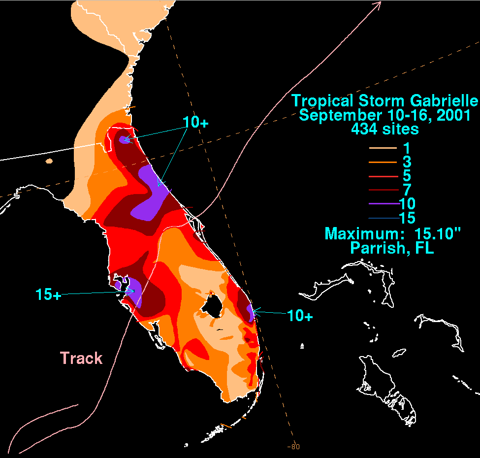
Gabrielle, at the time a tropical storm, produced a torrential amount of rain over the state of Florida. Amounts added up to between the 4-7 inch range along its track. A foot of rain fell in Volusia and Lake counties in northeast Florida. Other reports of urban flooding and river flooding was also acknowledged throughout the state. In addition to the severe flooding of up to one foot, many reports of tornadoes also poured in. In all, there were eighteen reports of twisters as Gabrielle came ashore.
September 11, 2001 attacks
The September 11 attacks The September 11 attacks The September 11 attacks (also referred to as September 11, September 11th or 9/119/11 is pronounced "nine eleven". The slash is not part of the pronunciation...
happened in New York City and Washington DC, forcing the FAA to ground public and private air traffic on the very day that this storm formed. As the storm approached an exemption was issued for Florida
Florida
Florida is a state in the southeastern United States, located on the nation's Atlantic and Gulf coasts. It is bordered to the west by the Gulf of Mexico, to the north by Alabama and Georgia and to the east by the Atlantic Ocean. With a population of 18,801,310 as measured by the 2010 census, it...
, Georgia
Georgia (U.S. state)
Georgia is a state located in the southeastern United States. It was established in 1732, the last of the original Thirteen Colonies. The state is named after King George II of Great Britain. Georgia was the fourth state to ratify the United States Constitution, on January 2, 1788...
, South Carolina
South Carolina
South Carolina is a state in the Deep South of the United States that borders Georgia to the south, North Carolina to the north, and the Atlantic Ocean to the east. Originally part of the Province of Carolina, the Province of South Carolina was one of the 13 colonies that declared independence...
, and Alabama
Alabama
Alabama is a state located in the southeastern region of the United States. It is bordered by Tennessee to the north, Georgia to the east, Florida and the Gulf of Mexico to the south, and Mississippi to the west. Alabama ranks 30th in total land area and ranks second in the size of its inland...
. Owners were able to evacuate their aircraft and provide emergency relief flights after the storm passed. http://www.aopa.org/page_2.html#n4ga
In all, Gabrielle killed two people directly and one indirectly. A fifteen-year-old boy died of drowning in Winter Springs, Florida
Winter Springs, Florida
Winter Springs is a city in Seminole County, Florida, United States. The population was 31,666 at the 2000 census. According to the 2009 Census Bureau estimates, the city has a population of 32,727...
. Another died due to a rip current off the coastline of Alabama
Alabama
Alabama is a state located in the southeastern region of the United States. It is bordered by Tennessee to the north, Georgia to the east, Florida and the Gulf of Mexico to the south, and Mississippi to the west. Alabama ranks 30th in total land area and ranks second in the size of its inland...
. The indirect death was the cause of an individual falling off a boat and drowning due to intoxication.
Bermuda and Canada
In BermudaBermuda
Bermuda is a British overseas territory in the North Atlantic Ocean. Located off the east coast of the United States, its nearest landmass is Cape Hatteras, North Carolina, about to the west-northwest. It is about south of Halifax, Nova Scotia, Canada, and northeast of Miami, Florida...
, the combination of Gabrielle and the cold front to its west dropped about 1.8 inches of precipitation in a 4 day period. Wind gusts peaked at 55 mi/h in an outer rainband. No damage was reported in the territory.
The extratropical remnant of Gabrielle passed a short distance south of Newfoundland, the second cyclone in less than a week to affect the area. The storm produced moderately strong wind gusts of over 60 mph (100 km) across the southern portion of the island, including a peak gust of 80 mph (130 km/h) at Cape Race
Cape Race
Cape Race is a point of land located at the southeastern tip of the Avalon Peninsula on the island of Newfoundland, Canada. Its name is thought to come from the original Portuguese name for this cape, "Raso", or "bare"...
. The storm also produced rough seas of up to 36 feet (11 m) in height. The remnant of Gabrielle dropped heavy rainfall in a short amount of time across Newfoundland, with one station at Cape Race recording 1.9 inches (48.3 mm) in just 1 hour. The rainfall set the all time 6 hour precipitation record at St. John's
St. John's, Newfoundland and Labrador
St. John's is the capital and largest city in Newfoundland and Labrador, and is the oldest English-founded city in North America. It is located on the eastern tip of the Avalon Peninsula on the island of Newfoundland. With a population of 192,326 as of July 1, 2010, the St...
, with a total of 3.54 inches (89.9 mm). Rainfall peaked at 6.9 inches (175 mm) at the Memorial University of Newfoundland
Memorial University of Newfoundland
Memorial University of Newfoundland, is a comprehensive university located primarily in St...
in St. John's.
In St. John's, the rainfall caused severe flooding, with the mayor of the city considering Gabrielle "the worst storm in 100 years". There, the flooding washed out roads and parking lots, and also flooded some basements with several feet (1 m) of water. There were multiple reports of sewers unable to accompany the excess of water. Hurricane force wind gusts canceled flights and left thousands without power, telephone, or heat. Hundreds of homes and buildings were damaged by the passage of Gabrielle, totaling several million dollars in damage.
Aftermath
In response to the flooding in St. John's, NewfoundlandSt. John's, Newfoundland and Labrador
St. John's is the capital and largest city in Newfoundland and Labrador, and is the oldest English-founded city in North America. It is located on the eastern tip of the Avalon Peninsula on the island of Newfoundland. With a population of 192,326 as of July 1, 2010, the St...
, the city mayor activated the city's Emergency Preparedness Program. On September 27, about a week after the passage of the storm, the Emergency Measures Organization began accepting applications for flood-related damage. By about a month after the storm, 169 applications were processed, with an additional 1,762 received by the Emergency Measures Organization. Eligibility for the disaster assistance included restoration to property or household items of an essential nature. A few days after the passage of the storm, the government of Newfoundland appealed to the federal government for federal disaster relief fund; the government later approved. Ultimately, disaster relief assistance totaled $6.3 million (2001 CAD), primarily to individual assistance.
See also
- List of Atlantic hurricanes
- List of Florida hurricanes
- Timeline of the 2001 Atlantic hurricane seasonTimeline of the 2001 Atlantic hurricane seasonThe timeline of the 2001 Atlantic hurricane season documents all the storm formations, strengthening, weakening, landfalls, extratropical transitions, as well as dissipation...
- List of Florida hurricanes (2000–present)