
Hurricane Fefa
Encyclopedia
Hurricane Fefa was a major Pacific hurricane
of the 1991 Pacific hurricane season
that despite causing minimal effects its name was removed from the list of tropical cyclone names. The sixth tropical storm, fourth hurricane, and second major hurricane of the season, the storm developed from a tropical wave
on July 29 about 975 miles (1,575 km) south-southeast of Cabo San Lucas
. It moved west-northwestward, and under generally favorable conditions it strengthened to attain peak winds of 120 mph (195 km/h) on August 2. Fefa turned to the west towards Hawaii
, and slowly weakened until dissipating near the island of Hawaii
.
The hurricane produced rough surf, moderate wind gusts, and locally heavy rainfall during its passage over Hawaii. No damages or deaths were reported. Two people were injured in the island of Hawaii due to lightning strikes from the storm.
exited the coast of Africa
on July 17. It tracked across the unfavorable Atlantic Ocean
and Caribbean Sea
without development, and after crossing Central America
, it entered the eastern Pacific Ocean
on July 25. The cloud pattern and convection began to become better organized on July 28, and shortly thereafter a mid-level circulation developed. It continued to organize, and subsequent to the development of a low-level circulation it formed into Tropical Depression Seven-E while located about 975 miles (1,575 km) south-southeast of Cabo San Lucas
on July 29. Operationally, tropical cyclone advisories were not initiated until visible satellite images confirmed the low-level circulation twelve hours after the depression formed.
Located over warm waters with fair upper level outflow, the depression quickly intensified and attained tropical storm status twelve hours after forming. Upon strengthening into a tropical storm, Fefa developed a curved cloud band
over the southern and eastern portion of the center. The storm slowly strengthened as it tracked west-northwestward, a motion due to the presence of a high-pressure
ridge
to its north. Fefa initially strengthened slowly; on the day after it became a tropical storm the center was located on the western edge of the deep convection. On July 31, convection began increasing over the center, and it is estimated it intensified into a hurricane later that day while located about 710 miles (1,145 km) southwest of the southern tip of Baja California
.
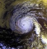
Initially, Fefa was forecast to intensify slightly after reaching hurricane status to reach peak winds of 80 mph (130 km/h). However, it quickly intensified after a large, ragged eye
developed early on August 1. On August 2, the eye organized further, and Fefa strengthened to attain a peak intensity of 120 mph (195 km/h) while located about 940 miles (1,510 km) west-southwest of Cabo San Lucas. Based on higher Dvorak numbers
, the hurricane could have peaked with winds stronger than 120 mph (195 km/h). Fefa encountered cooler waters shortly after peaking in intensity, and subsequently began to weaken. The hurricane gradually weakened as it turned more to the west, a change in motion due to building high pressures to its north, and on August 3 the winds of Fefa dropped to 85 mph (135 km/h) due to cooler water and dry air.
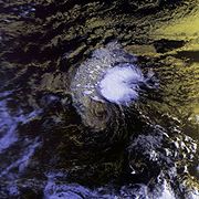 As Fefa turned more to the west, it paralleled the cooler waters, allowing the eye to remain distinct as the hurricane remained well-organized. Despite moving over marginally warm sea surface temperature
s and becoming involved with the Stratocumulus cloud
field to its north, the hurricane restrengthened on August 4 to reach a secondary peak intensity of 105 mph (170 km/h) while located about 1,265 miles (2,070 km) east-southeast of Hilo, Hawai'i
. After maintaining 105 mph (170 km/h) winds for about 18 hours, Fefa weakened slightly due to increasing wind shear
from a cold-core trough
as it entered the Central Pacific Hurricane Center
area of responsibility. As the shear increased, the cyclone weakened more rapidly, and on August 6 it weakened to a tropical storm while located about 650 miles (1,060 km) east of the island of Hawaii
. Initially, forecasters predicted Fefa to turn to the northwest to the north of the Hawaiian Islands
. However, the storm continued moving almost due westward as it steadily weakened. Aircraft reconnaissance
flew into Fefa three times as it neared Hawaii
. Late on August 7, Fefa weakened to a tropical depression a short distance of the island of Hawaii, and early on August 8 the depression began dissipating and degenerated into a tropical wave
after moving onshore. The remnants tracked west-northwestward and passed south of the Hawaiian Islands until dissipating on August 9 to the northwest of Kauai
.
 The prolonged westward track of Hurricane Fefa produced swells of up to 15 feet (4.5 m) in height. The swells hit eastward facing beaches along the island of Hawaii
. The swells washed debris and sea water onto coastal roads near Punaluu Black Sand Beach
, resulting in the roads being closed following the storm. Southwestern Maui
experienced rough surf, as well. Despite being a weak tropical depression and a tropical wave while moving through the Hawaiian Islands
, Fefa produced locally strong wind gusts of up to 50 mph (80 km/h) in the islands of Hawaii and Maui
.
Prior to moving across the island of Hawaii, strong thunderstorms developed in the northeastern portion of the remnant circulation of Fefa. The thunderstorms developed further as they moved over the slopes of Mauna Kea
and Kohala
. The thunderstorms produced heavy rainfall in areas, resulting in flash flood
ing in Kohala
and Hamakua
. Hurricane Fefa resulted in no known deaths. Lightning
from the storm caused two injuries. A man in Hawaii Volcanoes National Park
was hurt when lightning struck where he was walking. A man in Hilo was burnt when lightning moved through telephone wires. The storm resulted in no reported damage.
The name Fefa was removed after this storm and replaced with Felicia in the 1997 season
. It is unknown whether it was retired due to its damage or for another reason. Other possible reasons listed for the removal of a name are pronunciation ambiguity, a socially unacceptable meaning in another language, or because the storm name represented a significant human disaster.
Pacific hurricane
A Pacific hurricane or tropical storm is a tropical cyclone that develops in the northeastern part of the Pacific Ocean. For organizational purposes, the northern Pacific Ocean is divided into three regions: the eastern, , central , and western...
of the 1991 Pacific hurricane season
1991 Pacific hurricane season
The 1991 Pacific hurricane season was an event in tropical cyclone meteorology. The worst storm this year was Tropical Depression Five-E, which killed one person in Mexico. Elsewhere, Tropical Storm Ignacio injured forty people in Mexico, and Hurricane Fefa caused flooding in Hawaii...
that despite causing minimal effects its name was removed from the list of tropical cyclone names. The sixth tropical storm, fourth hurricane, and second major hurricane of the season, the storm developed from a tropical wave
Tropical wave
Tropical waves, easterly waves, or tropical easterly waves, also known as African easterly waves in the Atlantic region, are a type of atmospheric trough, an elongated area of relatively low air pressure, oriented north to south, which move from east to west across the tropics causing areas of...
on July 29 about 975 miles (1,575 km) south-southeast of Cabo San Lucas
Cabo San Lucas
Cabo San Lucas , commonly called Cabo, is a city at the southern tip of the Baja California peninsula, in the municipality of Los Cabos in the Mexican state of Baja California Sur. As of the 2010 census, the population was 68,463 people...
. It moved west-northwestward, and under generally favorable conditions it strengthened to attain peak winds of 120 mph (195 km/h) on August 2. Fefa turned to the west towards Hawaii
Hawaii
Hawaii is the newest of the 50 U.S. states , and is the only U.S. state made up entirely of islands. It is the northernmost island group in Polynesia, occupying most of an archipelago in the central Pacific Ocean, southwest of the continental United States, southeast of Japan, and northeast of...
, and slowly weakened until dissipating near the island of Hawaii
Hawaii (island)
The Island of Hawaii, also called the Big Island or Hawaii Island , is a volcanic island in the North Pacific Ocean...
.
The hurricane produced rough surf, moderate wind gusts, and locally heavy rainfall during its passage over Hawaii. No damages or deaths were reported. Two people were injured in the island of Hawaii due to lightning strikes from the storm.
Meteorological history
A westward-moving tropical waveTropical wave
Tropical waves, easterly waves, or tropical easterly waves, also known as African easterly waves in the Atlantic region, are a type of atmospheric trough, an elongated area of relatively low air pressure, oriented north to south, which move from east to west across the tropics causing areas of...
exited the coast of Africa
Africa
Africa is the world's second largest and second most populous continent, after Asia. At about 30.2 million km² including adjacent islands, it covers 6% of the Earth's total surface area and 20.4% of the total land area...
on July 17. It tracked across the unfavorable Atlantic Ocean
Atlantic Ocean
The Atlantic Ocean is the second-largest of the world's oceanic divisions. With a total area of about , it covers approximately 20% of the Earth's surface and about 26% of its water surface area...
and Caribbean Sea
Caribbean Sea
The Caribbean Sea is a sea of the Atlantic Ocean located in the tropics of the Western hemisphere. It is bounded by Mexico and Central America to the west and southwest, to the north by the Greater Antilles, and to the east by the Lesser Antilles....
without development, and after crossing Central America
Central America
Central America is the central geographic region of the Americas. It is the southernmost, isthmian portion of the North American continent, which connects with South America on the southeast. When considered part of the unified continental model, it is considered a subcontinent...
, it entered the eastern Pacific Ocean
Pacific Ocean
The Pacific Ocean is the largest of the Earth's oceanic divisions. It extends from the Arctic in the north to the Southern Ocean in the south, bounded by Asia and Australia in the west, and the Americas in the east.At 165.2 million square kilometres in area, this largest division of the World...
on July 25. The cloud pattern and convection began to become better organized on July 28, and shortly thereafter a mid-level circulation developed. It continued to organize, and subsequent to the development of a low-level circulation it formed into Tropical Depression Seven-E while located about 975 miles (1,575 km) south-southeast of Cabo San Lucas
Cabo San Lucas
Cabo San Lucas , commonly called Cabo, is a city at the southern tip of the Baja California peninsula, in the municipality of Los Cabos in the Mexican state of Baja California Sur. As of the 2010 census, the population was 68,463 people...
on July 29. Operationally, tropical cyclone advisories were not initiated until visible satellite images confirmed the low-level circulation twelve hours after the depression formed.
Located over warm waters with fair upper level outflow, the depression quickly intensified and attained tropical storm status twelve hours after forming. Upon strengthening into a tropical storm, Fefa developed a curved cloud band
Rainband
A rainband is a cloud and precipitation structure associated with an area of rainfall which is significantly elongated. Rainbands can be stratiform or convective, and are generated by differences in temperature. When noted on weather radar imagery, this precipitation elongation is referred to as...
over the southern and eastern portion of the center. The storm slowly strengthened as it tracked west-northwestward, a motion due to the presence of a high-pressure
Anticyclone
An anticyclone is a weather phenomenon defined by the United States' National Weather Service's glossary as "[a] large-scale circulation of winds around a central region of high atmospheric pressure, clockwise in the Northern Hemisphere, counterclockwise in the Southern Hemisphere"...
ridge
Ridge (meteorology)
A ridge is an elongated region of relatively high atmospheric pressure, the opposite of a trough....
to its north. Fefa initially strengthened slowly; on the day after it became a tropical storm the center was located on the western edge of the deep convection. On July 31, convection began increasing over the center, and it is estimated it intensified into a hurricane later that day while located about 710 miles (1,145 km) southwest of the southern tip of Baja California
Baja California Peninsula
The Baja California peninsula , is a peninsula in northwestern Mexico. Its land mass separates the Pacific Ocean from the Gulf of California. The Peninsula extends from Mexicali, Baja California in the north to Cabo San Lucas, Baja California Sur in the south.The total area of the Baja California...
.
Initially, Fefa was forecast to intensify slightly after reaching hurricane status to reach peak winds of 80 mph (130 km/h). However, it quickly intensified after a large, ragged eye
Eye (cyclone)
The eye is a region of mostly calm weather found at the center of strong tropical cyclones. The eye of a storm is a roughly circular area and typically 30–65 km in diameter. It is surrounded by the eyewall, a ring of towering thunderstorms where the second most severe weather of a cyclone...
developed early on August 1. On August 2, the eye organized further, and Fefa strengthened to attain a peak intensity of 120 mph (195 km/h) while located about 940 miles (1,510 km) west-southwest of Cabo San Lucas. Based on higher Dvorak numbers
Dvorak technique
The Dvorak technique is a widely used system to subjectively estimate tropical cyclone intensity based solely on visible and infrared satellite images. Several agencies issue Dvorak intensity numbers for cyclones of sufficient intensity...
, the hurricane could have peaked with winds stronger than 120 mph (195 km/h). Fefa encountered cooler waters shortly after peaking in intensity, and subsequently began to weaken. The hurricane gradually weakened as it turned more to the west, a change in motion due to building high pressures to its north, and on August 3 the winds of Fefa dropped to 85 mph (135 km/h) due to cooler water and dry air.
Sea surface temperature
Sea surface temperature is the water temperature close to the oceans surface. The exact meaning of surface varies according to the measurement method used, but it is between and below the sea surface. Air masses in the Earth's atmosphere are highly modified by sea surface temperatures within a...
s and becoming involved with the Stratocumulus cloud
Stratocumulus cloud
A Stratocumulus cloud belongs to a class of clouds characterized by large dark, rounded masses, usually in groups, lines, or waves, the individual elements being larger than those in altocumuli, and the whole being at a lower altitude, usually below 2,400 m...
field to its north, the hurricane restrengthened on August 4 to reach a secondary peak intensity of 105 mph (170 km/h) while located about 1,265 miles (2,070 km) east-southeast of Hilo, Hawai'i
Hilo, Hawai'i
Hilo is the largest census-designated place and the largest settlement on the Island of Hawaii, also known as the County of Hawaii. The population was 40,759 at the 2000 census. The population increased by 6.1% to 43,263 at the 2010 census....
. After maintaining 105 mph (170 km/h) winds for about 18 hours, Fefa weakened slightly due to increasing wind shear
Wind shear
Wind shear, sometimes referred to as windshear or wind gradient, is a difference in wind speed and direction over a relatively short distance in the atmosphere...
from a cold-core trough
Trough (meteorology)
A trough is an elongated region of relatively low atmospheric pressure, often associated with fronts.Unlike fronts, there is not a universal symbol for a trough on a weather chart. The weather charts in some countries or regions mark troughs by a line. In the United States, a trough may be marked...
as it entered the Central Pacific Hurricane Center
Central Pacific Hurricane Center
The Central Pacific Hurricane Center of the United States National Weather Service is the official body responsible for tracking and issuing tropical cyclone warnings, watches, advisories, discussions, and statements for the Central North Pacific Basin...
area of responsibility. As the shear increased, the cyclone weakened more rapidly, and on August 6 it weakened to a tropical storm while located about 650 miles (1,060 km) east of the island of Hawaii
Hawaii (island)
The Island of Hawaii, also called the Big Island or Hawaii Island , is a volcanic island in the North Pacific Ocean...
. Initially, forecasters predicted Fefa to turn to the northwest to the north of the Hawaiian Islands
Hawaiian Islands
The Hawaiian Islands are an archipelago of eight major islands, several atolls, numerous smaller islets, and undersea seamounts in the North Pacific Ocean, extending some 1,500 miles from the island of Hawaii in the south to northernmost Kure Atoll...
. However, the storm continued moving almost due westward as it steadily weakened. Aircraft reconnaissance
Hurricane Hunters
The Hurricane Hunters are aircraft that fly into tropical cyclones in the North Atlantic Ocean and Northeastern Pacific Ocean for the specific purpose of directly measuring weather data in and around those storms. In the United States, the Air Force, Navy, and NOAA units have all participated in...
flew into Fefa three times as it neared Hawaii
Hawaii
Hawaii is the newest of the 50 U.S. states , and is the only U.S. state made up entirely of islands. It is the northernmost island group in Polynesia, occupying most of an archipelago in the central Pacific Ocean, southwest of the continental United States, southeast of Japan, and northeast of...
. Late on August 7, Fefa weakened to a tropical depression a short distance of the island of Hawaii, and early on August 8 the depression began dissipating and degenerated into a tropical wave
Tropical wave
Tropical waves, easterly waves, or tropical easterly waves, also known as African easterly waves in the Atlantic region, are a type of atmospheric trough, an elongated area of relatively low air pressure, oriented north to south, which move from east to west across the tropics causing areas of...
after moving onshore. The remnants tracked west-northwestward and passed south of the Hawaiian Islands until dissipating on August 9 to the northwest of Kauai
Kauai
Kauai or Kauai, known as Tauai in the ancient Kaua'i dialect, is geologically the oldest of the main Hawaiian Islands. With an area of , it is the fourth largest of the main islands in the Hawaiian archipelago, and the 21st largest island in the United States. Known also as the "Garden Isle",...
.
Impact
Hawaii (island)
The Island of Hawaii, also called the Big Island or Hawaii Island , is a volcanic island in the North Pacific Ocean...
. The swells washed debris and sea water onto coastal roads near Punaluu Black Sand Beach
Punaluu Black Sand Beach
Punaluu Beach is a beach between Pāhala and Nāālehu on the Big Island of the U.S. state of Hawaii. The beach has black sand made of basalt and created by lava flowing into the ocean which explodes as it reaches the ocean and cools...
, resulting in the roads being closed following the storm. Southwestern Maui
Maui
The island of Maui is the second-largest of the Hawaiian Islands at and is the 17th largest island in the United States. Maui is part of the state of Hawaii and is the largest of Maui County's four islands, bigger than Lānai, Kahoolawe, and Molokai. In 2010, Maui had a population of 144,444,...
experienced rough surf, as well. Despite being a weak tropical depression and a tropical wave while moving through the Hawaiian Islands
Hawaiian Islands
The Hawaiian Islands are an archipelago of eight major islands, several atolls, numerous smaller islets, and undersea seamounts in the North Pacific Ocean, extending some 1,500 miles from the island of Hawaii in the south to northernmost Kure Atoll...
, Fefa produced locally strong wind gusts of up to 50 mph (80 km/h) in the islands of Hawaii and Maui
Maui
The island of Maui is the second-largest of the Hawaiian Islands at and is the 17th largest island in the United States. Maui is part of the state of Hawaii and is the largest of Maui County's four islands, bigger than Lānai, Kahoolawe, and Molokai. In 2010, Maui had a population of 144,444,...
.
Prior to moving across the island of Hawaii, strong thunderstorms developed in the northeastern portion of the remnant circulation of Fefa. The thunderstorms developed further as they moved over the slopes of Mauna Kea
Mauna Kea
Mauna Kea is a volcano on the island of Hawaii. Standing above sea level, its peak is the highest point in the state of Hawaii. However, much of the mountain is under water; when measured from its oceanic base, Mauna Kea is over tall—significantly taller than Mount Everest...
and Kohala
Kohala (mountain)
Kohala is the oldest of five volcanoes that make up the island of Hawaii. Kohala is an estimated one million years old—so old that it experienced, and recorded, a reversal of magnetic field 780,000 years ago. It is believed to have breached sea level more than 500,000 years ago and to...
. The thunderstorms produced heavy rainfall in areas, resulting in flash flood
Flash flood
A flash flood is a rapid flooding of geomorphic low-lying areas—washes, rivers, dry lakes and basins. It may be caused by heavy rain associated with a storm, hurricane, or tropical storm or meltwater from ice or snow flowing over ice sheets or snowfields...
ing in Kohala
Kohala, Hawaii
thumb|right|300px|The districts of the [[Hawaii |Big Island]]. From Northernmost, clockwise; Kohala , [[Hamakua|Hāmākua]], [[Hilo, Hawaii|Hilo]], [[Puna, Hawaii|Puna]], [[Kau, Hawaii|Kaū]], [[Kona District, Hawaii|Kona]]...
and Hamakua
Hamakua
thumb|right|280px|Districts of [[Hawaii |Hawaii island]]: from northernmost, clockwise; [[Kohala, Hawaii|Kohala]], Hāmākua , [[Hilo, Hawaii|Hilo]], [[Puna, Hawaii|Puna]], [[Kau, Hawaii|Kaū]], [[Kona District, Hawaii|Kona]]...
. Hurricane Fefa resulted in no known deaths. Lightning
Lightning
Lightning is an atmospheric electrostatic discharge accompanied by thunder, which typically occurs during thunderstorms, and sometimes during volcanic eruptions or dust storms...
from the storm caused two injuries. A man in Hawaii Volcanoes National Park
Hawaii Volcanoes National Park
Hawaii Volcanoes National Park, established in 1916, is a United States National Park located in the U.S. State of Hawaii on the island of Hawaii. It encompasses two active volcanoes: Kīlauea, one of the world's most active volcanoes, and Mauna Loa, the world's most massive volcano...
was hurt when lightning struck where he was walking. A man in Hilo was burnt when lightning moved through telephone wires. The storm resulted in no reported damage.
The name Fefa was removed after this storm and replaced with Felicia in the 1997 season
1997 Pacific hurricane season
The 1997 Pacific hurricane season was a very active hurricane season. With hundreds of deaths and billions of dollars in damage, this season was the costliest and one of the deadliest Pacific hurricane seasons. This was due to a strong El Niño...
. It is unknown whether it was retired due to its damage or for another reason. Other possible reasons listed for the removal of a name are pronunciation ambiguity, a socially unacceptable meaning in another language, or because the storm name represented a significant human disaster.
See also
- List of Pacific hurricanes
- List of retired Pacific hurricane names