
.gif)
Hurricane Claudette (2003)
Encyclopedia
Hurricane Claudette was the third tropical storm and first hurricane of the 2003 Atlantic hurricane season
. A fairly long-lived July Atlantic hurricane, Claudette began as a tropical wave in the eastern Caribbean. It moved quickly westward, brushing past the Yucatán Peninsula
before moving northwestward through the Gulf of Mexico
. Claudette remained a tropical storm until just before making landfall in Port O'Connor, Texas
, when it quickly strengthened to a strong Category 1 hurricane on the Saffir-Simpson Hurricane Scale
. Forecasting of its path and intensity was uncertain throughout its lifetime, resulting in widespread and often unnecessary preparations along its path.
Claudette was the first hurricane to make landfall in July in the United States since Hurricane Danny
in the 1997 season
. The hurricane caused one death and moderate damage in Texas
, mostly from strong winds, as well as extensive beach erosion. Because of the damage, President George W. Bush
declared portions of South Texas as a Federal Disaster Area, allowing the affected citizens to apply for aid. Claudette also caused significant rainfall and minor damage in the Mexican state of Quintana Roo
as a tropical storm, as well as minor damage on Saint Lucia
before developing into a tropical cyclone.
moved off the coast of Africa on July 1. It steadily organized as it moved westward, and resembled a tropical depression by July 7. However, surface reports and reconnaissance aircraft
indicated the system did not have tropical characteristics, and remained simply a low-pressure system. The wave produced tropical storm-force winds as it moved through the Lesser Antilles
on July 8, but did not acquire tropical characteristics until it reached the eastern Caribbean. Because it had tropical storm-force winds, the system was upgraded immediately to Tropical Storm Claudette after it developed a low-level circulation later on July 8.
By early on July 9, while south of Puerto Rico
, Claudette quickly strengthened over the warm waters of the Caribbean, and its strongest winds were just shy of the threshold for hurricane intensity. Possibly due to its fast forward motion, the storm became disorganized and weakened. Conditions briefly became more favorable over the western Caribbean, and Claudette reached hurricane status for six hours on July 10. Soon after, the storm encountered unfavorable upper-level winds and weakened back into a tropical storm. In response to a break in the subtropical ridge—a high-pressure ridge that often prevents tropical systems from moving northward—it turned to the west-northwest. Claudette made its first landfall
at Puerto Morelos
on the Yucatán Peninsula
on July 11 as a tropical storm with 60 mph (95 km/h) winds.
.jpg) Claudette wobbled to the northwest over the Gulf of Mexico
Claudette wobbled to the northwest over the Gulf of Mexico
and gradually restrengthened. Upper-level winds steadily decreased, and Claudette again became a hurricane late on July 14. Just prior to landfall
, it strengthened quickly and picked up its forward motion in a more westerly direction striking Port O'Connor, Texas
on July 15 as a Category 1 hurricane on the Saffir-Simpson Hurricane Scale
with 90 mph (145 km/h) winds. Residents along and inland of the central Texas coast were caught off guard both by its intensity and its time of arrival. The hurricane was projected to make landfall in the evening hours of July 15, but instead came ashore before noon. Furthermore, some initial estimates suggested that Claudette had reached Category 2 status, with sustained winds of up to 100 mph (160 km/h); these were based on unofficial observations which were not backed up by official data.
As slow as Claudette was to strengthen, it was also slow to dissipate over land. Inland hurricane warnings were issued for several counties away from the coastline and winds gusted to 83 mi/h at Victoria Regional Airport. It maintained tropical storm intensity for over 24 hours after landfall, a rarity for such a weak storm; most tropical systems weaken rapidly after landfall, as they are separated from the warm waters that power them. The storm finally lost its low-level circulation early on July 17 over Chihuahua, although its rainfall and upper-level circulation continued into the Pacific Ocean.
37 hours prior to the storm's landfall between Chetumal
and Cabo Catoche
, Quintana Roo
. The warning was upgraded to a hurricane warning about a day before landfall, but was downgraded when Claudette weakened just 13 hours prior to its landfall in the Yucatán Peninsula
. The Mexican government declared a state of emergency in the projected path of the storm, and declared an evacuation order for 1,500 citizens in Quintana Roo. There, residents remained calm during the evacuation.
Tourists left nightclubs for supermarkets to stock up on, among other items, beer, which was banned at midnight. Schools were set up as shelters, while police forced tourists to remain in their hotels.
The consistent variation in the path of Claudette caused uncertainty over the strength and location of its final landfall. On July 13, two days prior to Claudette's eventual landfall, the National Hurricane Center issued a hurricane watch
between Brownsville
and Port O'Connor, Texas
. By the next day, a hurricane warning existed from Baffin Bay
to High Island, Texas
, while a tropical storm warning extended from High Island to Intracoastal City, Louisiana
. When it became apparent that Louisiana would not be affected significantly by the storm, the state's tropical storm warnings were canceled. In Texas
, Galveston County
officials recommended evacuations for western Galveston Island
and Jamaica Beach
, 24 hours prior to Claudette's projected landfall. The Emergency Phone Notification System notified citizens in the evening to avoid evacuating during the night. Many citizens heeded the evacuation suggestion, some of whom remembered the flooding from Tropical Storm Frances
five years before.
 Hurricane Claudette also affected the oil industry
. ExxonMobil
, Chevron
, ConocoPhillips
, Shell Oil
, Marathon Oil
, Unocal Corporation
, and Anadarko Petroleum Corporation
all limited production and evacuated many of their workers. Chevron, which evacuated more than 1,800 workers, returned many of its workers on the day when Claudette made landfall. Unocal closed 23 rigs and platforms in the region. The combined closures stopped the daily production of 225000 barrels (35,772.1 m³) per day of oil and 2 billion cufts (56,633,694 m³) of natural gas, which accounted for 15% of the total production in the Gulf of Mexico.
, Hurricane Claudette caused little damage due to its low intensity. In total, damage estimates rose to $180 million (2003 USD
, $198 million 2006 USD), and the storm caused one direct and two indirect deaths. One of the indirect deaths occurred from a man having a heart attack while surfing in the eastern Gulf of Mexico
.
 As a tropical wave, Claudette dropped torrential rainfall and brought strong winds to the island of Saint Lucia
. The George F. L. Charles Airport
in Castries
reported a wind gust of 52 mph (84 km/h), while other parts of the island experienced nearly horizontal rainfall from the gusts. On the northern and eastern portions of the island, the strong winds ripped off roofs and downed trees across roadways. Overall, damage was light, and amounted to $1.1 million (2003 USD, $ USD).
In the Dominican Republic
, the outer bands of the storm caused moderate rainfall of up to 3 inches (80 mm) in Santo Domingo
. Winds gusted up to 45 mph (70 km/h), knocking down trees, sign posts, and iron roofs. Also, flooding in metropolitan areas blocked traffic for cars and pedestrians. Banana and other fruit plantations in the southwestern portion of the country experienced severe damage, although exact damage totals are unknown.
On Jamaica
, the storm caused wind gusts of 45 mph (70 km/h) in Montego Bay. Forecasters predicted high tides, strong waves, and up to 6 inches (150 mm) of rain on the island, although exact post-storm totals are not known. Many fishermen moved their boats from the water to safety, while a cruise line diverted three ships away from Claudette's path.
In the Cayman Islands
, where the storm remained 165 miles (265 km) away at its closest point, rainfall totals ranged from 1–3 inches (25–75 mm). On the south side of Grand Cayman
, Claudette caused wave heights of around 10 feet (3 m), while the western side received little precipitation. Also on Grand Cayman, the storm caused winds of 35–40 mph (55–65 km/h), causing minor tree damage but little else.
On Mexico's Yucatán Peninsula
, Claudette lashed strong waves against the coastline at Cancún
, but overall caused light damage. While crossing the peninsula, the storm dropped moderate rainfall, including a total of 3.22 inches (81 mm) in Cancún. Winds were moderate, causing the Cancún International Airport
to delay several flights, though there were no cancellations. Overall, Claudette sank a few small boats and flooded a few streets in Cancún, though damage was minor in the Yucatán Peninsula.
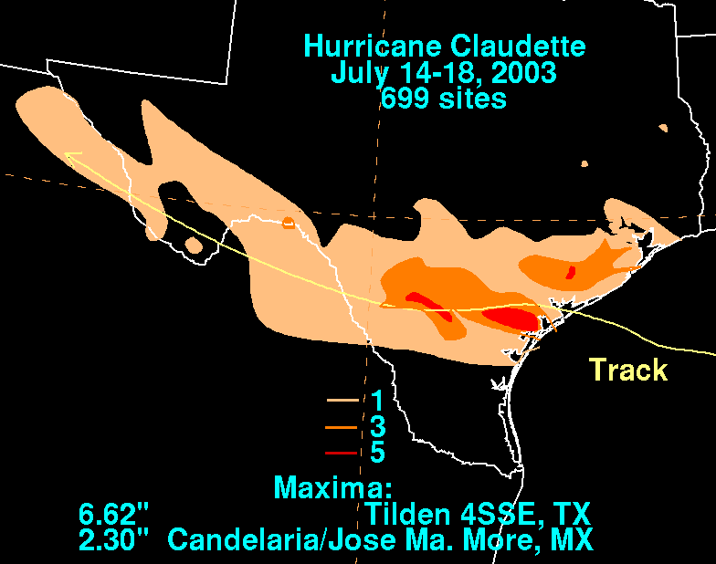
.jpg) Upon making landfall on the central Texas
Upon making landfall on the central Texas
coast, Claudette's storm surge
reached a maximum height of 5.3 feet (1.6 m) in Galveston
. Freeport
reported a "storm tide"—the overall rise of water over the mean low tide—of 9.15 feet (2.8 m). Claudette produced moderate rainfall across southern Texas, peaking at 6.5 inches (165 mm) in Tilden
. In Matagorda
, the local weather station measured winds of 75 mph (120 km/h)—the only official report of hurricane-force winds along the coastline. However, several offshore oil rigs reported winds of up to 90 mph (120 km/h), and one unofficial reading in Seadrift
indicated winds of 96.6 mph (156 km/h). This report would suggest the storm was a low-end Category 2 hurricane
, though this contradicted Hurricane Hunters
' data, which pointed to a storm of a lesser intensity.
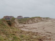
Severe beach erosion occurred from High Island
to Freeport
, though large geo-tubes reduced the erosion on Galveston Island
and the Bolivar Peninsula. The outer bands of the hurricane spawned two tornadoes. One was an F1 on the Fujita scale
that caused damage to several buildings in Palacios
, and the other damaged homes in Port Lavaca
.
Widespread flooding and gusty winds destroyed 204 houses along the southeast Texas coastline, most of which occurred in Matagorda County. In addition, the winds damaged 1,407 homes, with 144 of them being severely damaged. The wind also affected 147 businesses, of which 64 were either destroyed or severely damaged. Strong winds downed numerous power lines, leaving around 74,000 residents without power in the immediate aftermath. Overall, Claudette caused $180 million (2003 USD, $ USD) in damage in Texas and one death from a fallen tree during the storm. Also, the storm was indirectly responsible for a death when a tree fell on a person in the aftermath of the storm.
 On July 17, President George W. Bush
declared 18 south Texas
counties as a federal disaster area. Within 2 months of the storm, over 15,000 citizens registered for assistance. The government approved $34.8 million (2003 USD, $ USD) in aid, of which nearly half went to basic house repairs. The Federal Emergency Management Agency
(FEMA) provided 75% of the $1.35 million (2003 USD, $ USD) debris removal cost, with the other 25% being covered through local agencies. FEMA also provided $1.26 million (2003 USD, $ USD) to repair geo-tubes on the Bolivar Peninsula in Galveston County. The geo-tubes, which protect buildings along coastal areas, were severely damaged by the hurricane.
In western Texas, heavy rainfall of up to 5 inches (130 mm) temporarily sparked widespread growth of wildflowers in a normally arid landscape. The rainfall restored the flow of the Rio Grande
at Big Bend National Park
, which had ceased in the area due to lack of rainfall. In addition, the precipitation increased the water level in the Amistad National Recreation Area
to 4 feet (1.2 m).
2003 Atlantic hurricane season
The 2003 Atlantic hurricane season was an active Atlantic hurricane season with tropical activity before and after the official bounds of the season – the first such occurrence in 50 years. The season produced 21 tropical cyclones, of which 16 developed into named storms; seven...
. A fairly long-lived July Atlantic hurricane, Claudette began as a tropical wave in the eastern Caribbean. It moved quickly westward, brushing past the Yucatán Peninsula
Yucatán Peninsula
The Yucatán Peninsula, in southeastern Mexico, separates the Caribbean Sea from the Gulf of Mexico, with the northern coastline on the Yucatán Channel...
before moving northwestward through the Gulf of Mexico
Gulf of Mexico
The Gulf of Mexico is a partially landlocked ocean basin largely surrounded by the North American continent and the island of Cuba. It is bounded on the northeast, north and northwest by the Gulf Coast of the United States, on the southwest and south by Mexico, and on the southeast by Cuba. In...
. Claudette remained a tropical storm until just before making landfall in Port O'Connor, Texas
Port O'Connor, Texas
Port O'Connor is an unincorporated village in Calhoun County, Texas, United States, on the coastline between Galveston and Corpus Christi. The ZIP Code Tabulation Area including Port O'Connor had a population of 1,078 at the 2000 census...
, when it quickly strengthened to a strong Category 1 hurricane on the Saffir-Simpson Hurricane Scale
Saffir-Simpson Hurricane Scale
The Saffir–Simpson Hurricane Scale , or the Saffir–Simpson Hurricane Wind Scale , classifies hurricanes — Western Hemisphere tropical cyclones that exceed the intensities of tropical depressions and tropical storms — into five categories distinguished by the intensities of their sustained winds...
. Forecasting of its path and intensity was uncertain throughout its lifetime, resulting in widespread and often unnecessary preparations along its path.
Claudette was the first hurricane to make landfall in July in the United States since Hurricane Danny
Hurricane Danny (1997)
Hurricane Danny was the only hurricane to make landfall in the United States during the 1997 Atlantic hurricane season, and the second hurricane and fourth tropical storm of the season...
in the 1997 season
1997 Atlantic hurricane season
The 1997 Atlantic hurricane season is the most recent Atlantic hurricane season to feature no tropical cyclones in August. The season officially began on June 1, 1997, and lasted until November 30, 1997...
. The hurricane caused one death and moderate damage in Texas
Texas
Texas is the second largest U.S. state by both area and population, and the largest state by area in the contiguous United States.The name, based on the Caddo word "Tejas" meaning "friends" or "allies", was applied by the Spanish to the Caddo themselves and to the region of their settlement in...
, mostly from strong winds, as well as extensive beach erosion. Because of the damage, President George W. Bush
George W. Bush
George Walker Bush is an American politician who served as the 43rd President of the United States, from 2001 to 2009. Before that, he was the 46th Governor of Texas, having served from 1995 to 2000....
declared portions of South Texas as a Federal Disaster Area, allowing the affected citizens to apply for aid. Claudette also caused significant rainfall and minor damage in the Mexican state of Quintana Roo
Quintana Roo
Quintana Roo officially Estado Libre y Soberano de Quintana Roo is one of the 31 states which, with the Federal District, comprise the 32 Federal Entities of Mexico. It is divided in 10 municipalities and its capital city is Chetumal....
as a tropical storm, as well as minor damage on Saint Lucia
Saint Lucia
Saint Lucia is an island country in the eastern Caribbean Sea on the boundary with the Atlantic Ocean. Part of the Lesser Antilles, it is located north/northeast of the island of Saint Vincent, northwest of Barbados and south of Martinique. It covers a land area of 620 km2 and has an...
before developing into a tropical cyclone.
Meteorological history
A tropical waveTropical wave
Tropical waves, easterly waves, or tropical easterly waves, also known as African easterly waves in the Atlantic region, are a type of atmospheric trough, an elongated area of relatively low air pressure, oriented north to south, which move from east to west across the tropics causing areas of...
moved off the coast of Africa on July 1. It steadily organized as it moved westward, and resembled a tropical depression by July 7. However, surface reports and reconnaissance aircraft
Reconnaissance aircraft
A reconnaissance aircraft is a manned military aircraft designed, or adapted, to carry out aerial reconnaissance.-History:The majority of World War I aircraft were reconnaissance designs...
indicated the system did not have tropical characteristics, and remained simply a low-pressure system. The wave produced tropical storm-force winds as it moved through the Lesser Antilles
Lesser Antilles
The Lesser Antilles are a long, partly volcanic island arc in the Western Hemisphere. Most of its islands form the eastern boundary of the Caribbean Sea with the Atlantic Ocean, with the remainder located in the southern Caribbean just north of South America...
on July 8, but did not acquire tropical characteristics until it reached the eastern Caribbean. Because it had tropical storm-force winds, the system was upgraded immediately to Tropical Storm Claudette after it developed a low-level circulation later on July 8.
By early on July 9, while south of Puerto Rico
Puerto Rico
Puerto Rico , officially the Commonwealth of Puerto Rico , is an unincorporated territory of the United States, located in the northeastern Caribbean, east of the Dominican Republic and west of both the United States Virgin Islands and the British Virgin Islands.Puerto Rico comprises an...
, Claudette quickly strengthened over the warm waters of the Caribbean, and its strongest winds were just shy of the threshold for hurricane intensity. Possibly due to its fast forward motion, the storm became disorganized and weakened. Conditions briefly became more favorable over the western Caribbean, and Claudette reached hurricane status for six hours on July 10. Soon after, the storm encountered unfavorable upper-level winds and weakened back into a tropical storm. In response to a break in the subtropical ridge—a high-pressure ridge that often prevents tropical systems from moving northward—it turned to the west-northwest. Claudette made its first landfall
Landfall (meteorology)
Landfall is the event of a tropical cyclone or a waterspout coming onto land after being over water. When a waterspout makes landfall it is reclassified as a tornado, which can then cause damage inland...
at Puerto Morelos
Puerto Morelos
Puerto Morelos is a town and sea port in Quintana Roo, Mexico's easternmost state, on the Yucatán Peninsula. The town is at the southern end of the municipality of Benito Juárez in the northeast of the state, about 36 km south of the resort city of Cancún...
on the Yucatán Peninsula
Yucatán Peninsula
The Yucatán Peninsula, in southeastern Mexico, separates the Caribbean Sea from the Gulf of Mexico, with the northern coastline on the Yucatán Channel...
on July 11 as a tropical storm with 60 mph (95 km/h) winds.
Gulf of Mexico
The Gulf of Mexico is a partially landlocked ocean basin largely surrounded by the North American continent and the island of Cuba. It is bounded on the northeast, north and northwest by the Gulf Coast of the United States, on the southwest and south by Mexico, and on the southeast by Cuba. In...
and gradually restrengthened. Upper-level winds steadily decreased, and Claudette again became a hurricane late on July 14. Just prior to landfall
Landfall (meteorology)
Landfall is the event of a tropical cyclone or a waterspout coming onto land after being over water. When a waterspout makes landfall it is reclassified as a tornado, which can then cause damage inland...
, it strengthened quickly and picked up its forward motion in a more westerly direction striking Port O'Connor, Texas
Port O'Connor, Texas
Port O'Connor is an unincorporated village in Calhoun County, Texas, United States, on the coastline between Galveston and Corpus Christi. The ZIP Code Tabulation Area including Port O'Connor had a population of 1,078 at the 2000 census...
on July 15 as a Category 1 hurricane on the Saffir-Simpson Hurricane Scale
Saffir-Simpson Hurricane Scale
The Saffir–Simpson Hurricane Scale , or the Saffir–Simpson Hurricane Wind Scale , classifies hurricanes — Western Hemisphere tropical cyclones that exceed the intensities of tropical depressions and tropical storms — into five categories distinguished by the intensities of their sustained winds...
with 90 mph (145 km/h) winds. Residents along and inland of the central Texas coast were caught off guard both by its intensity and its time of arrival. The hurricane was projected to make landfall in the evening hours of July 15, but instead came ashore before noon. Furthermore, some initial estimates suggested that Claudette had reached Category 2 status, with sustained winds of up to 100 mph (160 km/h); these were based on unofficial observations which were not backed up by official data.
As slow as Claudette was to strengthen, it was also slow to dissipate over land. Inland hurricane warnings were issued for several counties away from the coastline and winds gusted to 83 mi/h at Victoria Regional Airport. It maintained tropical storm intensity for over 24 hours after landfall, a rarity for such a weak storm; most tropical systems weaken rapidly after landfall, as they are separated from the warm waters that power them. The storm finally lost its low-level circulation early on July 17 over Chihuahua, although its rainfall and upper-level circulation continued into the Pacific Ocean.
Preparations
Mexican officials issued a tropical storm warningTropical cyclone warnings and watches
Warnings and watches are two levels of alert issued by national weather forecasting bodies to coastal areas threatened by the imminent approach of a tropical cyclone of tropical storm or hurricane intensity. They are notices to the local population and civil authorities to make appropriate...
37 hours prior to the storm's landfall between Chetumal
Chetumal
Chetumal is a city on the east coast of the Yucatán Peninsula in Mexico. It is the capital of the state of Quintana Roo and the municipal seat of the Municipality of Othón P. Blanco...
and Cabo Catoche
Cabo Catoche
Cabo Catoche or Cape Catoche, in the Mexican state of Quintana Roo, is the northernmost point on the Yucatán Peninsula. It lies in the municipality of Isla Mujeres, about north of the city of Cancún....
, Quintana Roo
Quintana Roo
Quintana Roo officially Estado Libre y Soberano de Quintana Roo is one of the 31 states which, with the Federal District, comprise the 32 Federal Entities of Mexico. It is divided in 10 municipalities and its capital city is Chetumal....
. The warning was upgraded to a hurricane warning about a day before landfall, but was downgraded when Claudette weakened just 13 hours prior to its landfall in the Yucatán Peninsula
Yucatán Peninsula
The Yucatán Peninsula, in southeastern Mexico, separates the Caribbean Sea from the Gulf of Mexico, with the northern coastline on the Yucatán Channel...
. The Mexican government declared a state of emergency in the projected path of the storm, and declared an evacuation order for 1,500 citizens in Quintana Roo. There, residents remained calm during the evacuation.
Tourists left nightclubs for supermarkets to stock up on, among other items, beer, which was banned at midnight. Schools were set up as shelters, while police forced tourists to remain in their hotels.
The consistent variation in the path of Claudette caused uncertainty over the strength and location of its final landfall. On July 13, two days prior to Claudette's eventual landfall, the National Hurricane Center issued a hurricane watch
Tropical cyclone warnings and watches
Warnings and watches are two levels of alert issued by national weather forecasting bodies to coastal areas threatened by the imminent approach of a tropical cyclone of tropical storm or hurricane intensity. They are notices to the local population and civil authorities to make appropriate...
between Brownsville
Brownsville, Texas
Brownsville is a city in the southernmost tip of the state of Texas, in the United States. It is located on the northern bank of the Rio Grande, directly north and across the border from Matamoros, Tamaulipas, Mexico. Brownsville is the 16th largest city in the state of Texas with a population of...
and Port O'Connor, Texas
Port O'Connor, Texas
Port O'Connor is an unincorporated village in Calhoun County, Texas, United States, on the coastline between Galveston and Corpus Christi. The ZIP Code Tabulation Area including Port O'Connor had a population of 1,078 at the 2000 census...
. By the next day, a hurricane warning existed from Baffin Bay
Baffin Bay, Texas
Baffin Bay is a bay in South Texas, an inlet of the larger Laguna Madre. Located near the Gulf of Mexico, Baffin Bay forms part of the boundary between Kenedy County and Kleberg County.-Etymology:The history of the bay name is unclear...
to High Island, Texas
High Island, Texas
High Island is an unincorporated area located in the Bolivar Peninsula census-designated place, Galveston County, Texas, United States. The community is located in the extreme eastern part of the county on Bolivar Peninsula, less than one mile from Chambers County and less than two miles from...
, while a tropical storm warning extended from High Island to Intracoastal City, Louisiana
Intracoastal City, Louisiana
Intracoastal City is an unincorporated community in Vermilion Parish, Louisiana, United States. It is situated on the west bank of the Vermilion River at its junction with the Gulf Intracoastal Waterway and has various port facilities and some permanent residents.Intracoastal City is approximately...
. When it became apparent that Louisiana would not be affected significantly by the storm, the state's tropical storm warnings were canceled. In Texas
Texas
Texas is the second largest U.S. state by both area and population, and the largest state by area in the contiguous United States.The name, based on the Caddo word "Tejas" meaning "friends" or "allies", was applied by the Spanish to the Caddo themselves and to the region of their settlement in...
, Galveston County
Galveston County, Texas
Galveston County is a county located in the U.S. state of Texas within the Houston–Sugar Land–Baytown metropolitan area. As of the 2010 U.S. Census, the population was 291,309. Its county seat is Galveston. League City is the largest city in Galveston County in terms of population; between...
officials recommended evacuations for western Galveston Island
Galveston Island
Galveston Island is a barrier island on the Texas Gulf coast in the United States, about 50 miles southeast of Houston. The entire island, with the exception of Jamaica Beach, is within the city limits of the City of Galveston....
and Jamaica Beach
Jamaica Beach, Texas
Jamaica Beach is a city in Galveston County, Texas, United States. As of the 2000 census, the city population was 1,075.-History:Prior to its development, Jamaica Beach was a Karankawa burial ground. Johnny Goyen and Earl Galceran of the Jamaica Corporation developed Jamaica Beach as a 2,000-lot...
, 24 hours prior to Claudette's projected landfall. The Emergency Phone Notification System notified citizens in the evening to avoid evacuating during the night. Many citizens heeded the evacuation suggestion, some of whom remembered the flooding from Tropical Storm Frances
Tropical Storm Frances (1998)
Originating over the southwest Caribbean sea on September 4, Tropical Storm Frances became the sixth tropical storm of the 1998 Atlantic hurricane season. The cyclone moved northward through the western Gulf of Mexico, making landfall across the central Texas coastline before recurving across the...
five years before.
2003 world oil market chronology
*January 6: Venezuelan Minister of Energy and Mines Rafael Ramírez announces that the Venezuelan government plans to split state oil company Petroleos de Venezuela S.A. into two separate entities as part of a large-scale restructuring of the company, most of whose 40,000 workers are currently on...
. ExxonMobil
ExxonMobil
Exxon Mobil Corporation or ExxonMobil, is an American multinational oil and gas corporation. It is a direct descendant of John D. Rockefeller's Standard Oil company, and was formed on November 30, 1999, by the merger of Exxon and Mobil. Its headquarters are in Irving, Texas...
, Chevron
Chevron Corporation
Chevron Corporation is an American multinational energy corporation headquartered in San Ramon, California, United States and active in more than 180 countries. It is engaged in every aspect of the oil, gas, and geothermal energy industries, including exploration and production; refining,...
, ConocoPhillips
ConocoPhillips
ConocoPhillips Company is an American multinational energy corporation with its headquarters located in the Energy Corridor district of Houston, Texas in the United States...
, Shell Oil
Royal Dutch Shell
Royal Dutch Shell plc , commonly known as Shell, is a global oil and gas company headquartered in The Hague, Netherlands and with its registered office in London, United Kingdom. It is the fifth-largest company in the world according to a composite measure by Forbes magazine and one of the six...
, Marathon Oil
Marathon Oil
Marathon Oil Corporation is a United States-based oil and natural gas exploration and production company. Principal exploration activities are in the United States, Norway, Equatorial Guinea, Angola and Canada. Principal development activities are in the United States, the United Kingdom, Norway,...
, Unocal Corporation
Unocal Corporation
Union Oil Company of California, dba Unocal is a defunct company that was a major petroleum explorer and marketer in the late 19th century, through the 20th century, and into the early 21st century. It was headquartered in El Segundo, California, United States.On August 10, 2005, Unocal merged...
, and Anadarko Petroleum Corporation
Anadarko Petroleum Corporation
Anadarko Petroleum Corporation is one of the world’s largest independent oil and gas exploration and production companies, with approximately 2.3 billion barrels of oil equivalent of proved reserves and production of 206 million BOE as of December 31, 2008. Anadarko employs a worldwide...
all limited production and evacuated many of their workers. Chevron, which evacuated more than 1,800 workers, returned many of its workers on the day when Claudette made landfall. Unocal closed 23 rigs and platforms in the region. The combined closures stopped the daily production of 225000 barrels (35,772.1 m³) per day of oil and 2 billion cufts (56,633,694 m³) of natural gas, which accounted for 15% of the total production in the Gulf of Mexico.
Impact
Outside of TexasTexas
Texas is the second largest U.S. state by both area and population, and the largest state by area in the contiguous United States.The name, based on the Caddo word "Tejas" meaning "friends" or "allies", was applied by the Spanish to the Caddo themselves and to the region of their settlement in...
, Hurricane Claudette caused little damage due to its low intensity. In total, damage estimates rose to $180 million (2003 USD
United States dollar
The United States dollar , also referred to as the American dollar, is the official currency of the United States of America. It is divided into 100 smaller units called cents or pennies....
, $198 million 2006 USD), and the storm caused one direct and two indirect deaths. One of the indirect deaths occurred from a man having a heart attack while surfing in the eastern Gulf of Mexico
Gulf of Mexico
The Gulf of Mexico is a partially landlocked ocean basin largely surrounded by the North American continent and the island of Cuba. It is bounded on the northeast, north and northwest by the Gulf Coast of the United States, on the southwest and south by Mexico, and on the southeast by Cuba. In...
.
Caribbean Sea
Saint Lucia
Saint Lucia is an island country in the eastern Caribbean Sea on the boundary with the Atlantic Ocean. Part of the Lesser Antilles, it is located north/northeast of the island of Saint Vincent, northwest of Barbados and south of Martinique. It covers a land area of 620 km2 and has an...
. The George F. L. Charles Airport
George F. L. Charles Airport
- Charter :-Cargo Services:* Federal Express* DHL* Ameriflight* Corporate Air...
in Castries
Castries
Castries , population 10,634, aggl. 37,963 , is the capital city of Saint Lucia, a country in the Caribbean. The district with the same name had a population of 61,341 in 2001-05-22, and stretches over an area of ....
reported a wind gust of 52 mph (84 km/h), while other parts of the island experienced nearly horizontal rainfall from the gusts. On the northern and eastern portions of the island, the strong winds ripped off roofs and downed trees across roadways. Overall, damage was light, and amounted to $1.1 million (2003 USD, $ USD).
In the Dominican Republic
Dominican Republic
The Dominican Republic is a nation on the island of La Hispaniola, part of the Greater Antilles archipelago in the Caribbean region. The western third of the island is occupied by the nation of Haiti, making Hispaniola one of two Caribbean islands that are shared by two countries...
, the outer bands of the storm caused moderate rainfall of up to 3 inches (80 mm) in Santo Domingo
Santo Domingo
Santo Domingo, known officially as Santo Domingo de Guzmán, is the capital and largest city in the Dominican Republic. Its metropolitan population was 2,084,852 in 2003, and estimated at 3,294,385 in 2010. The city is located on the Caribbean Sea, at the mouth of the Ozama River...
. Winds gusted up to 45 mph (70 km/h), knocking down trees, sign posts, and iron roofs. Also, flooding in metropolitan areas blocked traffic for cars and pedestrians. Banana and other fruit plantations in the southwestern portion of the country experienced severe damage, although exact damage totals are unknown.
On Jamaica
Jamaica
Jamaica is an island nation of the Greater Antilles, in length, up to in width and 10,990 square kilometres in area. It is situated in the Caribbean Sea, about south of Cuba, and west of Hispaniola, the island harbouring the nation-states Haiti and the Dominican Republic...
, the storm caused wind gusts of 45 mph (70 km/h) in Montego Bay. Forecasters predicted high tides, strong waves, and up to 6 inches (150 mm) of rain on the island, although exact post-storm totals are not known. Many fishermen moved their boats from the water to safety, while a cruise line diverted three ships away from Claudette's path.
In the Cayman Islands
Cayman Islands
The Cayman Islands is a British Overseas Territory and overseas territory of the European Union located in the western Caribbean Sea. The territory comprises the three islands of Grand Cayman, Cayman Brac, and Little Cayman, located south of Cuba and northwest of Jamaica...
, where the storm remained 165 miles (265 km) away at its closest point, rainfall totals ranged from 1–3 inches (25–75 mm). On the south side of Grand Cayman
Grand Cayman
Grand Cayman is the largest of the three Cayman Islands and the location of the nation's capital, George Town. In relation to the other two Cayman Islands, it is approximately 75 miles southwest of Little Cayman and 90 miles southwest of Cayman Brac.-Geography:Grand Cayman encompasses 76% of...
, Claudette caused wave heights of around 10 feet (3 m), while the western side received little precipitation. Also on Grand Cayman, the storm caused winds of 35–40 mph (55–65 km/h), causing minor tree damage but little else.
On Mexico's Yucatán Peninsula
Yucatán Peninsula
The Yucatán Peninsula, in southeastern Mexico, separates the Caribbean Sea from the Gulf of Mexico, with the northern coastline on the Yucatán Channel...
, Claudette lashed strong waves against the coastline at Cancún
Cancún
Cancún is a city of international tourism development certified by the UNWTO . Located on the northeast coast of Quintana Roo in southern Mexico, more than 1,700 km from Mexico City, the Project began operations in 1974 as Integrally Planned Center, a pioneer of FONATUR Cancún is a city of...
, but overall caused light damage. While crossing the peninsula, the storm dropped moderate rainfall, including a total of 3.22 inches (81 mm) in Cancún. Winds were moderate, causing the Cancún International Airport
Cancún International Airport
Cancún International Airport is located in Cancún, Quintana Roo, on the Caribbean coast of Mexico's Yucatán Peninsula. It is Mexico's second busiest airport, after Mexico City International Airport in Mexico City, but the biggest in Mexico and Latin America for International passengers...
to delay several flights, though there were no cancellations. Overall, Claudette sank a few small boats and flooded a few streets in Cancún, though damage was minor in the Yucatán Peninsula.
Texas
Texas
Texas is the second largest U.S. state by both area and population, and the largest state by area in the contiguous United States.The name, based on the Caddo word "Tejas" meaning "friends" or "allies", was applied by the Spanish to the Caddo themselves and to the region of their settlement in...
coast, Claudette's storm surge
Storm surge
A storm surge is an offshore rise of water associated with a low pressure weather system, typically tropical cyclones and strong extratropical cyclones. Storm surges are caused primarily by high winds pushing on the ocean's surface. The wind causes the water to pile up higher than the ordinary sea...
reached a maximum height of 5.3 feet (1.6 m) in Galveston
Galveston, Texas
Galveston is a coastal city located on Galveston Island in the U.S. state of Texas. , the city had a total population of 47,743 within an area of...
. Freeport
Freeport, Texas
Freeport is a city in Brazoria County, Texas within the Houston–Sugar Land–Baytown metropolitan area and is situated in Southeast Texas. As of the 2000 U.S...
reported a "storm tide"—the overall rise of water over the mean low tide—of 9.15 feet (2.8 m). Claudette produced moderate rainfall across southern Texas, peaking at 6.5 inches (165 mm) in Tilden
Tilden, Texas
Tilden is an unincorporated community in and the county seat of McMullen County, Texas, United States.Tilden lies at the intersection of State Highways 16 and 72 in the north central part of the county. It is located roughly an hour south of San Antonio....
. In Matagorda
Matagorda Island
Matagorda Island, Spanish for "thick brush," is a 38 mile long barrier island on the Texas Gulf coast, about seven miles south of Port O'Connor, in the southernmost part of Calhoun County. The island is oriented generally northeast-southwest, with the Gulf of Mexico on the east and south, and...
, the local weather station measured winds of 75 mph (120 km/h)—the only official report of hurricane-force winds along the coastline. However, several offshore oil rigs reported winds of up to 90 mph (120 km/h), and one unofficial reading in Seadrift
Seadrift, Texas
Seadrift is a city in Calhoun County, Texas, United States. The population was 1,352 at the 2000 census. It is a part of the Victoria, Texas Metropolitan Statistical Area.-Geography:...
indicated winds of 96.6 mph (156 km/h). This report would suggest the storm was a low-end Category 2 hurricane
Saffir-Simpson Hurricane Scale
The Saffir–Simpson Hurricane Scale , or the Saffir–Simpson Hurricane Wind Scale , classifies hurricanes — Western Hemisphere tropical cyclones that exceed the intensities of tropical depressions and tropical storms — into five categories distinguished by the intensities of their sustained winds...
, though this contradicted Hurricane Hunters
Hurricane Hunters
The Hurricane Hunters are aircraft that fly into tropical cyclones in the North Atlantic Ocean and Northeastern Pacific Ocean for the specific purpose of directly measuring weather data in and around those storms. In the United States, the Air Force, Navy, and NOAA units have all participated in...
' data, which pointed to a storm of a lesser intensity.
Severe beach erosion occurred from High Island
High Island, Texas
High Island is an unincorporated area located in the Bolivar Peninsula census-designated place, Galveston County, Texas, United States. The community is located in the extreme eastern part of the county on Bolivar Peninsula, less than one mile from Chambers County and less than two miles from...
to Freeport
Freeport, Texas
Freeport is a city in Brazoria County, Texas within the Houston–Sugar Land–Baytown metropolitan area and is situated in Southeast Texas. As of the 2000 U.S...
, though large geo-tubes reduced the erosion on Galveston Island
Galveston Island
Galveston Island is a barrier island on the Texas Gulf coast in the United States, about 50 miles southeast of Houston. The entire island, with the exception of Jamaica Beach, is within the city limits of the City of Galveston....
and the Bolivar Peninsula. The outer bands of the hurricane spawned two tornadoes. One was an F1 on the Fujita scale
Fujita scale
The Fujita scale , or Fujita-Pearson scale, is a scale for rating tornado intensity, based primarily on the damage tornadoes inflict on human-built structures and vegetation...
that caused damage to several buildings in Palacios
Palacios, Texas
-Demographics:As of the census of 2000, there were 5,153 people, 1,661 households, and 1,244 families residing in the city. The population density was 1,021.4 people per square mile . There were 1,976 housing units at an average density of 391.7 per square mile...
, and the other damaged homes in Port Lavaca
Port Lavaca, Texas
Port Lavaca is a city in Calhoun County, Texas, United States. The population was 12,248 at the 2010 census. The County had a 3.6% growth which brought the county population to 21,381. The city itself is bringing in more business into the area. It is the county seat of Calhoun County...
.
Widespread flooding and gusty winds destroyed 204 houses along the southeast Texas coastline, most of which occurred in Matagorda County. In addition, the winds damaged 1,407 homes, with 144 of them being severely damaged. The wind also affected 147 businesses, of which 64 were either destroyed or severely damaged. Strong winds downed numerous power lines, leaving around 74,000 residents without power in the immediate aftermath. Overall, Claudette caused $180 million (2003 USD, $ USD) in damage in Texas and one death from a fallen tree during the storm. Also, the storm was indirectly responsible for a death when a tree fell on a person in the aftermath of the storm.
Aftermath
George W. Bush
George Walker Bush is an American politician who served as the 43rd President of the United States, from 2001 to 2009. Before that, he was the 46th Governor of Texas, having served from 1995 to 2000....
declared 18 south Texas
Texas
Texas is the second largest U.S. state by both area and population, and the largest state by area in the contiguous United States.The name, based on the Caddo word "Tejas" meaning "friends" or "allies", was applied by the Spanish to the Caddo themselves and to the region of their settlement in...
counties as a federal disaster area. Within 2 months of the storm, over 15,000 citizens registered for assistance. The government approved $34.8 million (2003 USD, $ USD) in aid, of which nearly half went to basic house repairs. The Federal Emergency Management Agency
Federal Emergency Management Agency
The Federal Emergency Management Agency is an agency of the United States Department of Homeland Security, initially created by Presidential Reorganization Plan No. 1 of 1978 and implemented by two Executive Orders...
(FEMA) provided 75% of the $1.35 million (2003 USD, $ USD) debris removal cost, with the other 25% being covered through local agencies. FEMA also provided $1.26 million (2003 USD, $ USD) to repair geo-tubes on the Bolivar Peninsula in Galveston County. The geo-tubes, which protect buildings along coastal areas, were severely damaged by the hurricane.
In western Texas, heavy rainfall of up to 5 inches (130 mm) temporarily sparked widespread growth of wildflowers in a normally arid landscape. The rainfall restored the flow of the Rio Grande
Rio Grande
The Rio Grande is a river that flows from southwestern Colorado in the United States to the Gulf of Mexico. Along the way it forms part of the Mexico – United States border. Its length varies as its course changes...
at Big Bend National Park
Big Bend National Park
Big Bend National Park is a national park located in the U.S. state of Texas. Big Bend has national significance as the largest protected area of Chihuahuan Desert topography and ecology in the United States, which includes more than 1,200 species of plants, more than 450 species of birds, 56...
, which had ceased in the area due to lack of rainfall. In addition, the precipitation increased the water level in the Amistad National Recreation Area
Amistad National Recreation Area
Amistad National Recreation Area includes the area around the Amistad Reservoir at the confluence of the Rio Grande River, the Devils River, and the Pecos River. "Amistad" is Spanish for "friendship", as the Amistad Reservoir is located on the border with Mexico...
to 4 feet (1.2 m).
See also
- Other storms of the same name