
Howard Frankland Bridge
Encyclopedia
The W. Howard Frankland Bridge is the central bridge spanning Old Tampa Bay
from St. Petersburg, Florida
to Tampa, Florida
. It is one of three bridges connecting Hillsborough County
and Pinellas County; the others being Gandy Bridge
and Courtney Campbell Causeway. The bridge carries Interstate 275
and is by far the most traveled of the bay's bridges.
The bridge is often incorrectly referred to as the Howard Franklin Bridge, including (as of August 2009) on Google Maps
.
 Named for the man who proposed it, Tampa businessman Howard Frankland
, the bridge opened in April 1960 and carried four lanes (two lanes in each direction separated by a short, narrow barrier). The bridge and approaches cost $16 million.
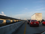
Because of the bridge's design, including its lack of emergency shoulders, it proved to be dangerous. Accidents were common on the bridge and traffic backed up on both sides, leading to local nicknames, the "Frankenstein" and "The Car-Strangled Spanner". In 1962, a steel-reinforced tapered concrete barrier was installed "to prevent cars from hurtling the median and crashing into oncoming traffic." Ten people had already died. The bridge was the subject of a 60 Minutes
broadcast in the 1960s noting the below-average construction methods used.
Planning for a larger-capacity replacement began in 1978. Original plans ranged from a large, multi-lane suspension (or similar type) bridge, to two parallel bridges (with the central span reserved for HOV lanes). As traffic projections increased, further exacerbated by a disaster on the Sunshine Skyway Bridge
in 1980, it was clear that the new bridge would need to handle at least eight lanes (four in each direction). By 1987, it was concluded that a parallel, four lane span would be built. Plans were also made to rehabilitate the older bridge after the new bridge opened.
Construction began on the new span in 1988. The new $54 million southbound span was opened to traffic in 1990. The older bridge was then closed, rehabilitated, and reopened in 1992. The older northbound span is shorter and has a steeper hump than the newer southbound span.
, to the Lee Roy Selmon Expressway, Willow Avenue, Howard Avenue, and ending at Interstate 275. Special shields (marked N and S) along the route made sure that drivers were using the correct thoroughfare.
/Veterans Expressway
exit. On the St. Petersburg side, after a comprehensive reconstruction project that took over ten years, lane counts were increased from four lanes prior to the bridge to six lanes through downtown St. Petersburg, and eight lanes from Gandy Boulevard to the bridge.
A reconstruction project was planned to begin in 2007 for I-275 between the Howard Frankland and downtown Tampa. However, due to rising cost of materials, FDOT planned to reconstruct the interstate in smaller phases rather than the original larger two-phase project. Once the reconstruction project is finished (about 2013), major traffic congestion on the Howard Frankland is expected to be significantly reduced.
Tampa Bay
Tampa Bay is a large natural harbor and estuary along the Gulf of Mexico on the west central coast of Florida, comprising Hillsborough Bay, Old Tampa Bay, Middle Tampa Bay, and Lower Tampa Bay."Tampa Bay" is not the name of any municipality...
from St. Petersburg, Florida
St. Petersburg, Florida
St. Petersburg is a city in Pinellas County, Florida, United States. It is known as a vacation destination for both American and foreign tourists. As of 2008, the population estimate by the U.S. Census Bureau is 245,314, making St...
to Tampa, Florida
Tampa, Florida
Tampa is a city in the U.S. state of Florida. It serves as the county seat for Hillsborough County. Tampa is located on the west coast of Florida. The population of Tampa in 2010 was 335,709....
. It is one of three bridges connecting Hillsborough County
Hillsborough County, Florida
As of the census of 2000, there were 998,948 people, 391,357 households, and 255,164 families residing in the county. The population density was 951 people per square mile . There were 425,962 housing units at an average density of 405 per square mile...
and Pinellas County; the others being Gandy Bridge
Gandy Bridge
Gandy Bridge is the southernmost bridge spanning Old Tampa Bay from St. Petersburg, Florida to Tampa, Florida. Almost three miles long, it is one of three bridges connecting Hillsborough County and Pinellas County; the others being the Howard Frankland Bridge and the Courtney Campbell...
and Courtney Campbell Causeway. The bridge carries Interstate 275
Interstate 275 (Florida)
Interstate 275 in Florida serves the Tampa Bay metropolitan area, measuring 60.696 miles in length. The southern terminus is I-75 near Palmetto, just five miles east of the Sunshine Skyway Bridge, a toll bridge crossing Tampa Bay. The highway passes through St...
and is by far the most traveled of the bay's bridges.
The bridge is often incorrectly referred to as the Howard Franklin Bridge, including (as of August 2009) on Google Maps
Google Maps
Google Maps is a web mapping service application and technology provided by Google, free , that powers many map-based services, including the Google Maps website, Google Ride Finder, Google Transit, and maps embedded on third-party websites via the Google Maps API...
.
History
William Howard Frankland
William Howard Frankland was an American businessman who proposed the W. Howard Frankland Bridge over Old Tampa Bay.The son of a horse buggy seller, he arrived in Tampa, Florida in 1925 from Jackson, Tennessee...
, the bridge opened in April 1960 and carried four lanes (two lanes in each direction separated by a short, narrow barrier). The bridge and approaches cost $16 million.
Because of the bridge's design, including its lack of emergency shoulders, it proved to be dangerous. Accidents were common on the bridge and traffic backed up on both sides, leading to local nicknames, the "Frankenstein" and "The Car-Strangled Spanner". In 1962, a steel-reinforced tapered concrete barrier was installed "to prevent cars from hurtling the median and crashing into oncoming traffic." Ten people had already died. The bridge was the subject of a 60 Minutes
60 Minutes
60 Minutes is an American television news magazine, which has run on CBS since 1968. The program was created by producer Don Hewitt who set it apart by using a unique style of reporter-centered investigation....
broadcast in the 1960s noting the below-average construction methods used.
Planning for a larger-capacity replacement began in 1978. Original plans ranged from a large, multi-lane suspension (or similar type) bridge, to two parallel bridges (with the central span reserved for HOV lanes). As traffic projections increased, further exacerbated by a disaster on the Sunshine Skyway Bridge
Sunshine Skyway Bridge
The Bob Graham Sunshine Skyway Bridge is a bridge spanning Tampa Bay, Florida, with a cable-stayed main span, and a total length of 21,877 feet . It is part of I-275 and US 19 , connecting St. Petersburg in Pinellas County and Terra Ceia in Manatee County, Florida, passing through Hillsborough...
in 1980, it was clear that the new bridge would need to handle at least eight lanes (four in each direction). By 1987, it was concluded that a parallel, four lane span would be built. Plans were also made to rehabilitate the older bridge after the new bridge opened.
Construction began on the new span in 1988. The new $54 million southbound span was opened to traffic in 1990. The older bridge was then closed, rehabilitated, and reopened in 1992. The older northbound span is shorter and has a steeper hump than the newer southbound span.
Bypass system
Before the parallel bridge was built, I-275 boasted a bypass designation system. Whenever there would be a major delay at the Howard Frankland Bridge, special signs would alert drivers to the delay and direct them to utilize the bypass, which ran along SR 694State Road 694 (Florida)
State Road 694 is an east–west route in Pinellas County originally running east from Indian Shores, through Seminole and into Pinellas Park; it now begins in Pinellas Park at 66th Street N, with the former road to the west becoming Pinellas County Road 694. It then turns to the northeast as...
, to the Lee Roy Selmon Expressway, Willow Avenue, Howard Avenue, and ending at Interstate 275. Special shields (marked N and S) along the route made sure that drivers were using the correct thoroughfare.
Reconstruction of the bridge approaches
After the widening project in 1992, Interstate 275 was increased to eight lanes on the bridge itself. However, this did not increase capacity on either end of the bridge. Backups were still seen on the Howard Frankland heading into Tampa, primarily due to a bottleneck at the SR 60State Road 60 (Florida)
State Road 60 is an east–west route transversing Florida from the Gulf of Mexico to the Atlantic Ocean. The western terminus of SR 60 is at the Sunsets at Pier 60 in Clearwater...
/Veterans Expressway
State Road 589 (Florida)
The Veterans Expressway and Suncoast Parkway is a north–south toll road near the Florida Gulf Coast. Maintained and operated by Florida's Turnpike Enterprise, this transportation corridor extends from State Road 60 in Tampa, north to U.S. Route 98 near Chassahowitzka...
exit. On the St. Petersburg side, after a comprehensive reconstruction project that took over ten years, lane counts were increased from four lanes prior to the bridge to six lanes through downtown St. Petersburg, and eight lanes from Gandy Boulevard to the bridge.
A reconstruction project was planned to begin in 2007 for I-275 between the Howard Frankland and downtown Tampa. However, due to rising cost of materials, FDOT planned to reconstruct the interstate in smaller phases rather than the original larger two-phase project. Once the reconstruction project is finished (about 2013), major traffic congestion on the Howard Frankland is expected to be significantly reduced.
External links
- Howard Frankland Bridge page at Interstate275Florida.com
- I-275 plan hits $100M bump Article on the 2006 I-275 expansion setback St. Petersburg Times (June 28, 2006)