

Horizontal coordinate system
Encyclopedia

Celestial coordinate system
In astronomy, a celestial coordinate system is a coordinate system for mapping positions on the celestial sphere.There are different celestial coordinate systems each using a system of spherical coordinates projected on the celestial sphere, in analogy to the geographic coordinate system used on...
that uses the observer's local horizon
Horizon
The horizon is the apparent line that separates earth from sky, the line that divides all visible directions into two categories: those that intersect the Earth's surface, and those that do not. At many locations, the true horizon is obscured by trees, buildings, mountains, etc., and the resulting...
as the fundamental plane
Fundamental plane (spherical coordinates)
The fundamental plane in a spherical coordinate system is a plane which divides the sphere into two hemispheres. The latitude of a point is then the angle between the fundamental plane and the line joining the point to the centre of the sphere....
. This coordinate system divides the sky into the upper hemisphere
Sphere
A sphere is a perfectly round geometrical object in three-dimensional space, such as the shape of a round ball. Like a circle in two dimensions, a perfect sphere is completely symmetrical around its center, with all points on the surface lying the same distance r from the center point...
where objects are visible, and the lower hemisphere where objects cannot be seen since the earth is in the way. The pole of the upper hemisphere is called the zenith
Zenith
The zenith is an imaginary point directly "above" a particular location, on the imaginary celestial sphere. "Above" means in the vertical direction opposite to the apparent gravitational force at that location. The opposite direction, i.e...
. The pole of the lower hemisphere is called the nadir
Nadir
The nadir is the direction pointing directly below a particular location; that is, it is one of two vertical directions at a specified location, orthogonal to a horizontal flat surface there. Since the concept of being below is itself somewhat vague, scientists define the nadir in more rigorous...
.
The horizontal coordinates are:
- Altitude (Alt), sometimes referred to as elevationElevation (disambiguation)Elevation is the height of a geographic location above mean sea levelElevation may also refer to:*Elevation , the lifting of consecrated bread and wine in Mass...
, is the angle between the object and the observer's local horizon. It is expressed as an angle between 0 degrees to 90 degrees. - Azimuth (Az), that is the angle of the object around the horizon, usually measured from the north increasing towards the east.
- Zenith distance, the distance from directly overhead (i.e. the zenith) is sometimes used instead of altitude in some calculations using these coordinates. The zenith distance is the complementComplementIn many different fields, the complement of X is something that together with X makes a complete whole—something that supplies what X lacks.Complement may refer to:...
of altitude (i.e. 90°-altitude).
The horizontal coordinate system is sometimes also called the az/el or Alt/Az coordinate system.
General observations
The horizontal coordinate system is fixed to the Earth, not the stars. Therefore, the altitude and azimuth of an object changes with time, as the object appears to drift across the sky. In addition, because the horizontal system is defined by the observer's local horizon, the same object viewed from different locations on Earth at the same time will have different values of altitude and azimuth.Horizontal coordinates are very useful for determining the rise and set times of an object in the sky. When an object's altitude is 0°, it is on the horizon. If at that moment its altitude is increasing, it is rising, but if its altitude is decreasing it is setting. However, all objects on the celestial sphere are subject to diurnal motion
Diurnal motion
Diurnal motion is an astronomical term referring to the apparent daily motion of stars around the Earth, or more precisely around the two celestial poles. It is caused by the Earth's rotation on its axis, so every star apparently moves on a circle, that is called the diurnal circle. The time for...
, which is always from east to west. One can determine whether altitude is increasing or decreasing by instead considering the azimuth of the celestial object:
- if the azimuth is between 0° and 180° (north–east–south), it is rising.
- if the azimuth is between 180° and 360° (south–west–north), it is setting.
There are the following special cases:
- At the north pole all directions are south, and at the south pole all directions are north, so the azimuth is undefined in both locations. A star (or any object with fixed equatorial coordinates) has constant altitude, and therefore never rises or sets when viewed from either pole. The SunSunThe Sun is the star at the center of the Solar System. It is almost perfectly spherical and consists of hot plasma interwoven with magnetic fields...
, MoonMoonThe Moon is Earth's only known natural satellite,There are a number of near-Earth asteroids including 3753 Cruithne that are co-orbital with Earth: their orbits bring them close to Earth for periods of time but then alter in the long term . These are quasi-satellites and not true moons. For more...
, and planets can rise or set over the span of a year when viewed from the poles because their right ascensionRight ascensionRight ascension is the astronomical term for one of the two coordinates of a point on the celestial sphere when using the equatorial coordinate system. The other coordinate is the declination.-Explanation:...
s and declinationDeclinationIn astronomy, declination is one of the two coordinates of the equatorial coordinate system, the other being either right ascension or hour angle. Declination in astronomy is comparable to geographic latitude, but projected onto the celestial sphere. Declination is measured in degrees north and...
s are constantly changing. - At the equator objects on the celestial poles stay at fixed points on the horizon.
Note that the above considerations are strictly speaking true for the geometric horizon only: the horizon as it would appear for an observer at sea level on a perfectly smooth Earth without an atmosphere. In practice the apparent horizon has a negative altitude, whose absolute value gets larger as the observer ascends higher above sea level, due to the curvature of the Earth. In addition, atmospheric refraction
Atmospheric refraction
Atmospheric refraction is the deviation of light or other things like humanelectromagnetic wave from a straight line as it passes through the atmosphere due to the variation in air density as a function of altitude...
causes celestial objects very close to the horizon to appear about half a degree higher than they would if there were no atmosphere.
Transformation of coordinates
It is possible to convert from the equatorial coordinate systemEquatorial coordinate system
The equatorial coordinate system is a widely-used method of mapping celestial objects. It functions by projecting the Earth's geographic poles and equator onto the celestial sphere. The projection of the Earth's equator onto the celestial sphere is called the celestial equator...
to the horizontal coordinate system and back. Define variables as follows:
- φ = geographic latitudeLatitudeIn geography, the latitude of a location on the Earth is the angular distance of that location south or north of the Equator. The latitude is an angle, and is usually measured in degrees . The equator has a latitude of 0°, the North pole has a latitude of 90° north , and the South pole has a...
- A = azimuth
- a = altitude
- δ = declinationDeclinationIn astronomy, declination is one of the two coordinates of the equatorial coordinate system, the other being either right ascension or hour angle. Declination in astronomy is comparable to geographic latitude, but projected onto the celestial sphere. Declination is measured in degrees north and...
- H = hour angleHour angleIn astronomy and celestial navigation, the hour angle is one of the coordinates used in the equatorial coordinate system to give the position of a point on the celestial sphere....
equatorial to horizontal
The following procedure allows conversion of equatorial coordinates to horizontal coordinates.


One may be tempted to simplify the last two equations by dividing out the cos a term, leaving one expression in tan A only. But the tangent cannot distinguish between (for example) an azimuth of 45° and 225°. These two values are very different: they are opposite directions, NE and SW respectively. One can do this only when the quadrant in which the azimuth lies is already known.
If the calculation is done with an electronic pocket calculator, it is best not to use the functions arcsin and arccos when possible, because of their limited 180° only range, and also because of the low accuracy the former gets around ±90° and the latter around 0° and 180°. Most scientific calculators have a rectangular to polar (R→P) and polar to rectangular (P→R) function, which avoids that problem and gives us an extra sanity check as well.
The algorithm then becomes as follows.
- Calculate the right hand side of the three equations given above.
- Apply a R→P conversion taking X = cos A cos a, and Y = sin A cos a.
- The angle part of the answer is the azimuth.
- Apply a second R→P conversion taking the radius part of the last answer as the X and the sin a of the first equation as the Y value.
- The angle part of the answer is the altitude, an angle between −90° and +90°.
- The radius part of the answer must be 1 exactly, or you have made an error.
horizontal to equatorial


The same quadrant considerations from the first set of formulas also hold for this set.
The position of the Sun
There are several ways to compute the apparent position of the Sun in horizontal coordinates.Complete and accurate algorithms to obtain precise values can be found in Jean Meeus
Jean Meeus
Jean Meeus is a Belgian astronomer specializing in celestial mechanics. The asteroid 2213 Meeus is named after him.Jean Meeus studied mathematics at the University of Leuven in Belgium, where he received the Degree of Licentiate in 1953...
's book Astronomical Algorithms.
Instead a simple approximate algorithm is the following:
Given:
- the dateCalendar dateA date in a calendar is a reference to a particular day represented within a calendar system. The calendar date allows the specific day to be identified. The number of days between two dates may be calculated. For example, "24 " is ten days after "14 " in the Gregorian calendar. The date of a...
of the year and the timeTimeTime is a part of the measuring system used to sequence events, to compare the durations of events and the intervals between them, and to quantify rates of change such as the motions of objects....
of the day - the observer's latitudeLatitudeIn geography, the latitude of a location on the Earth is the angular distance of that location south or north of the Equator. The latitude is an angle, and is usually measured in degrees . The equator has a latitude of 0°, the North pole has a latitude of 90° north , and the South pole has a...
, longitudeLongitudeLongitude is a geographic coordinate that specifies the east-west position of a point on the Earth's surface. It is an angular measurement, usually expressed in degrees, minutes and seconds, and denoted by the Greek letter lambda ....
and time zoneTime zoneA time zone is a region on Earth that has a uniform standard time for legal, commercial, and social purposes. In order for the same clock time to always correspond to the same portion of the day as the Earth rotates , different places on the Earth need to have different clock times...
You have to compute:
- The Sun declination of the corresponding day of the year, which is given by the following formula which has less than 2 degrees of error:
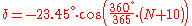
where
 is the number of days spent since January 1.
- The true hour angleHour angleIn astronomy and celestial navigation, the hour angle is one of the coordinates used in the equatorial coordinate system to give the position of a point on the celestial sphere....
that is the angle which the earth should rotate to take the observer's location directly under the sun.- Let hh:mm be the time the observer reads on the clock.
- Merge the hours and the minutes in one variable
 = hh + mm/60 measured in hours.
 - hh:mm is the official time of the time zone, but it is different from the true local time of the observer's location.
 has to be corrected adding the quantity + (Longitude/15 – Time Zone), which is measured in hours and represents the difference of time between the true local time of the observer's location and the official time of the time zone.
 - If it is summer and Daylight Saving TimeDaylight saving timeDaylight saving time —also summer time in several countries including in British English and European official terminology —is the practice of temporarily advancing clocks during the summertime so that afternoons have more daylight and mornings have less...
is used, you have to subtract one hour in order to get Standard TimeStandard timeStandard time is the result of synchronizing clocks in different geographical locations within a time zone to the same time rather than using the local meridian as in local mean time or solar time. Historically, this helped in the process of weather forecasting and train travel. The concept...
. - The value of the Equation of TimeEquation of timeThe equation of time is the difference between apparent solar time and mean solar time. At any given instant, this difference will be the same for every observer...
in that day has to be added. Since is measured in hours, the Equation of Time must be divided by 60 before being added.
 - The hour angle can be now computed. In fact the angle which the earth should rotate to take the observer's location directly under the sun is given by the following expression:
 = (12 –
  ) * 15. Since
  is measured in hours and the speed of rotation of the earth 15 degrees per hour,
  is measured in degrees. If you need
  measured in radians you just have to multiply by the factor 2π/360.
- Use the Transformation of Coordinates to compute the apparent position of the Sun in horizontal coordinates.